Holy Well (lost): OS Grid Reference – SE 134 331 (approximation)
Archaeology & History
This site is both interesting and frustrating at the same time. Interesting inasmuch that as early as 1258 CE, “the Knights Hospitallers of St. John of Jerusalem in England, had in Allerton a manor called the manor of Crosley.” The Hospitallers, as some will know, were the immediate successors of the more famous Knights Templars. As their name suggests, their patron saint was St John, whose festival date was summer solstice and had his name given to many holy wells. But this one has left us with no name and its location has long since been lost. In J.H. Bell’s (1888) essay on the early medical history of the area he told that local people with certain afflictions, “were wont to resort to them to drink their waters for their supposed medicinal virtues: there was one between Cemetery Bridge and Crossley Hall”. But he doesn’t give its exact position. In John James’ (1841) classic History of Bradford he thinks that near the place where the local stream known as the Hebble, “there was undoubtedly in former times a Holy well,” but is unable to cite a location. No well is shown on the early maps between the old Hall and the cemetery and the only definitive reference to wells close by are in the early boundary perambulation record, which describe a Brock Well and a Cold Well. Perhaps the the most probable contender and location is cited in Harry Speight’s (aka Johnnie Gray) Pleasant Walks (1890) where, taking a route between Great Horton and Allerton, he told us to,
“go through fields on to Necropolis Road, opposite Scholemoor cemetery, turn down lane left outside cemetery, ½ mile, descending steps, cross beck (here used to be the Spa Beck public gardens, now removed higher up) and ascend, at second field, leaving the forward path and turn left, following beck with Crosley Hall and trees to right.”
The location of the said Spa Beck gardens is very close to where Mr Bell described the medicinal spring and is/was the most likely position of what James (1841) thought to be a long lost holy well. If we could get more information about the history of the Spa Well, we may be able to make more definitive statements about the place.
Tumulus (destroyed): OS Grid Reference – SE 099 321
Archaeology & History
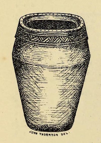
Headley Farm urn
There are no longer any remains of the prehistoric burial site that once stood in one of the fields by Lower Headley Farm. We don’t know whether the site was a cairn, a tumulus, or just a stone-lined cist; but in all probability it would have been a low rounded hillock whose existence had long since fallen out of oral tradition. All that we do know is that in one of the fields by the farm, some very well preserved urns—either neolithic or Bronze Age by the look of it—were unearthed, indicating a site of prehistoric provenance.
The finds were described only briefly in the first edition of the Bradford Antiquary (1888) journal, where it was reported:
“During the spring of 1880 an interesting discovery was made by Mr. Abraham Craven, quarryman, of Thornton. The ‘find’ comprised three funeral urns, which Mr. Craven turned up while baring a portion of a field in Lower Headley Farm, the property of the trustees of Sowerby Grammar School. The discovery was made within a short distance of the surface, the pottery presenting undoubted indications of pre-Roman origin. From evidence collected upon the spot, and the appearance of the pottery, two of the urns were about 14in in height, 9in across the top, 11½in at the widest portion of the bowl, and 6in at the foot. One of the urns was of sun-burnt clay, with rude markings, the other having evidently been subjected to fire. No coins, personal ornaments, or other indications of civilisation, were found in the urns, but each one contained human dust and bones. From the fact that several other urns have been met with in the immediate vicinity, equally rude in type, evidence is not wanting that the picturesque mound upon which Headley is situate was inhabited at a very early period of British history.”
References:
Anonymous, “Valuable ‘Find’ at Headley, near Thornton,” in Bradford Antiquary, volume 1, 1888.
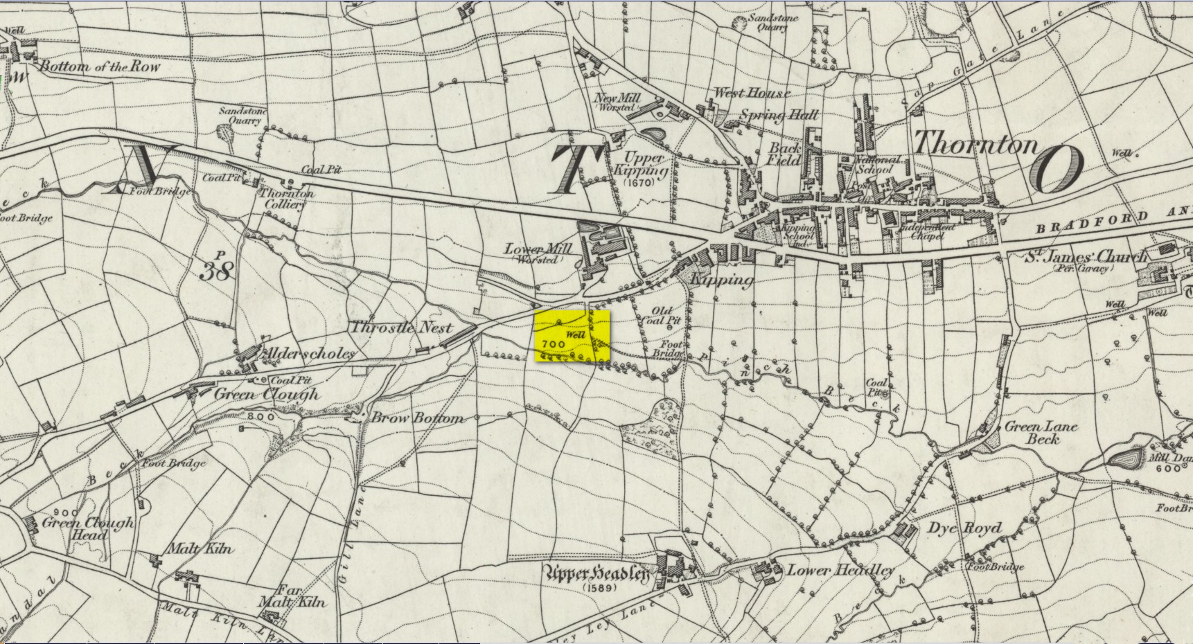
Another well with considerable supernatural renown was this little-known site near the old village of Thornton, on the western outskirts of Bradford. We’re not 100% sure about its exact location, but the grid-reference cited here is of an old ‘Well’ that was highlighted on the first Ordnance Survey map of the region, at the end of solitary path which led to it and nowhere else. Our only documentary information comes from Elizabeth’s Southwart’s (1932) fine old book on the folk life of the old village, as it once was. At a place once known as Bent Ing Bottom, just south of the old village, is where it used to be known. The name of this Well is also curious, as no historian has yet worked out who the ‘Jim Craven’ was, nor what his relationship to the site might have been. It’s the folklore of it, however, which brings it the attention it deserves.
Folklore
In Elizabeth Southwart’s (1923) work, she told us that the place once known as “Bent Ing Bottoms have lost their romance.” She continued:
“Whether the golfers have driven it away—for the fields now form part of the Thornton Golf Links—or whether the advance of modernity in other forms is to blame, it is difficult to say. Once they were the haunts of “Peggy-Wi-T’-Lantern” and the Bloody-tongue. Peggy, a dame in a white mob cap, kilted skirt and white stockings, walked about with a lantern, enticing the unwary traveller to his doom. She was given to wandering, for, they say, Jim Craven Well, half a mile away, was a place to be avoided after nightfall.
“The Bloody-tongue was a great dog, with staring red eyes, a tail as big as the branch of a tree, and a lolling tongue that dripped blood. When he drank from the beck (known as the Pinch Beck, PB) the water ran red right past the bridge, and away down—down—nearly to Bradford town. As soon as it was quite dark he would lope up the narrow flagged causeway to the cottage at the top of Bent Ing on the north side, give one deep bark, then the woman who lived there would come out and feed him. What he ate we never knew, but I can bear testimony to the delicious taste of the toffee she made.
“When the dark was coming we used to sit on the filled-in pit, which makes a hump in the middle of the field, and wait for him. The sun would sink redly, through the arches of the viaduct, the trees that lined the beck would grow an ever darker green until they became black, the beck would begin to gurgle and gulp in a queer way; and down in the hollow we would hear a whimper, a whine, a moan, a snarl. Then, with scalps and spines playing queer tricks, we would wait and wait. But none of our little band ever saw him, except one girl, and she saw him every time.
“One Saturday a girl who lived at Headley came to a birthday party in the village, and was persuaded to stay to the end by her friends, who promised to see her ‘a-gaiterds’ if she would. As soon as the party was over the brave little group started out. But when they reached the end of the passage which leads to the fields, and gazed into the black well, at the bottom of which lurked the Bloody-tongue, one of them suggested that Mary should go alone, and they would wait there to see if anything happened to her.
“Mary was reluctant, but had no choice in the matter, for go home she must. They waited, according to promise, listening to her footsteps on the path, and occasionally shouting into the darkness:
““Are you all right, Mary?”
““Ay!” would come the response.
“And well was it for Mary that the Gytrash had business elsewhere that night, for her friends confess now that at the first sound of a scream they would have fled back to lights and home.
“We wonder sometimes if the Booody-tongue were not better than his reputation, for he lived there many years and there was never a single case known of man, woman or child who got a bite from his teeth, or a scratch from his claws. Now he is gone, nobody knows whither, though there have been rumours that he has been seen wandering disconsolately along Egypt Road, whimpering quietly to himself, creeping into the shadows when a human being approached, and, when a lantern was flashed on him, giving one sad, reproachful glance from his red eyes before he vanished from sight.”
Southwart later tells us that the ghostly dog travelled into the north and vanished. From the description she gives of the children walking their friend to “the end of the passage which leads to the fields, and gazed into the black well, at the bottom of which lurked the Bloody-tongue,” I can only surmise that the solitary well shown on the very first OS-map of Thornton at the coordinate given above is the place in question.
The ‘Bloody Tongue’ is first mentioned in Yorkshire folklore, I think, by Roger Storrs, in his article on holy wells in 1888, where he tells it to be one of the mysterious beings that live, usually at the bottom of the waters and almost universally used “to deter children from playing in dangerous proximity to a well.”
From the description of the waters turning red when the ghostly dog drank from it, we have a mythic account of when the waters occasionally turned red from the iron-bearing waters (chalybeate) which, obviously, wasn’t like this at all times. Whether this was a sporadic, unpredictable flow of iron in the waters, or a cyclical pattern of the water-flows, we are not told (which would imply, moreso, that it was sporadic). The folklore about this ghost and its appearance with another elemental creature along an old straight track running north from Upper Headley Hall to Thornton is intriguing—as in many old pre-christian traditions, North is the airt, or direction, representing Death; and black dogs are traditionally guardians of underworld treasures in the land of the Dead. With the plethora of other animistic folktales once known in this district (boggarts or goblins were known in nearby woods, wells and farms) it is likely that the origin of such folklore dates way back into antiquity.
References:
Bennett, Paul, Ancient and Holy Wells of West Yorkshire, forthcoming
Southwart, Elizabeth, Bronte Moors and Villages: From Thornton to Haworth, John Lane Bodley Head: London 1923.
Storrs, Roger, ‘Legends and Traditions of Wells,’ in Yorkshire Folk-lore Journal – volume 1 (ed. J. Horsfall Turner) 1888.
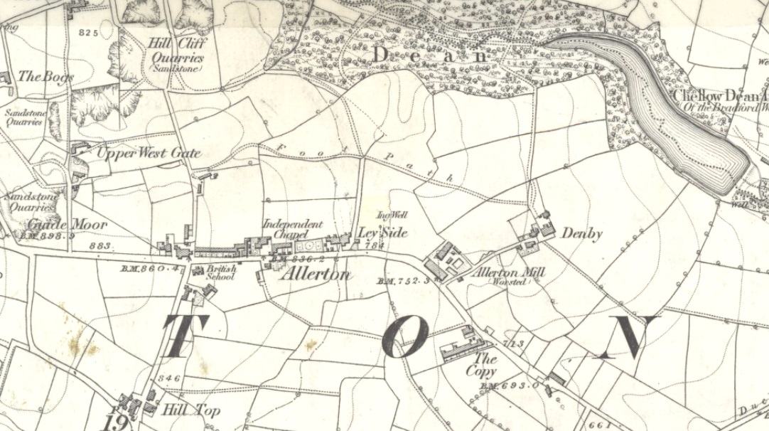
Healing Well (destroyed): OS Grid Reference – SE 1174 3443
Archaeology & History
Ing Well on 1852 map
This ‘Well of the Meadow”, or Ing Well, is one of countless springs in and around the Bradford metropolis that have been destroyed by that thing they call ‘development’. It was one of the main water sources for the villagers of Allerton village in the 19th century and earlier. Highlighted on the 1852 OS-map of the region, a singular footpath once led to the waters and no further. There appear to be no antiquarian or historical references detailing its traditions or medicinal qualities—unless of course, you know different.
The name Ing Wells is one of the most common of all titles given to water supplies in England, meaning having the same meaning and general history just about everywhere it occurs. The place-name itself was given extensive attention in two separate studies by Eilert Ekwall (1962) and Sigurd Karlstrom (1927).
References:
Ekwall, Eilert, English Place-Names in -Ing, Lund: Uppsala 1962.
Karlstrom, Sigurd, Old English Compound Place-Names in -Ing, Lund: Uppsala 1927.
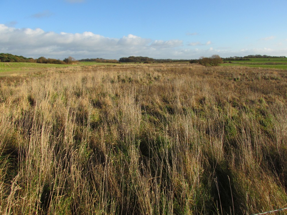
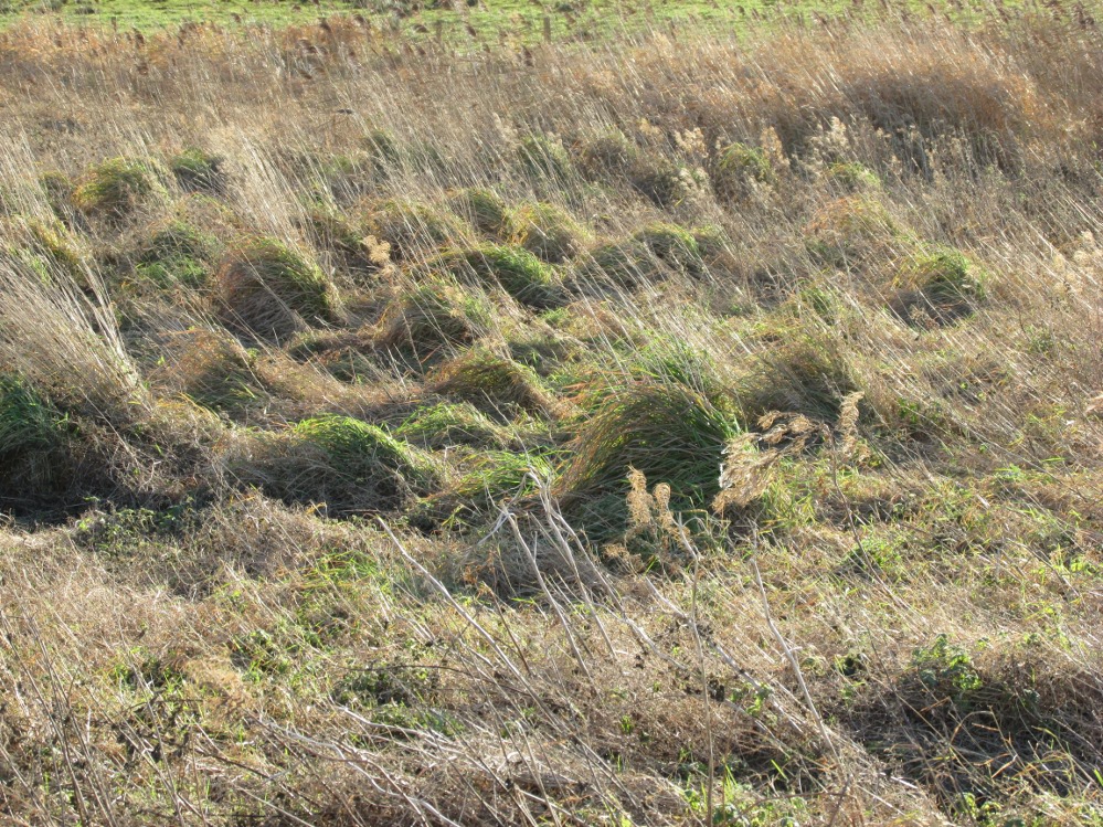
The boggy ground of the Bull Spring – from the site of possible cairn
To get here, leave Staining village along Mill Lane, turning right at the windmill along Smithy Lane. Walk along Smithy Lane, then 2-300 yards past a derelict piggery on the left go into the gated trackway on the right, and Bull Meadow is to the south-east, a boggy area at the western end of OS parcel 356. Be prepared to cross barbed wire fences.
Archaeology & History
Like the Staining Wrangdomwell or Fairy Spring recorded elsewhere, knowledge of this site owes its historical survival to the writings of Blackpool cleric, Rev. William Thornber (1803 – 1885), who wrote in 1851 about the now forgotton ‘Teanla’ or Hallowe’en bonfire cairns of Hardhorn:
“…but here adjoining the cairns are attached two wells, the one celebrated as Fairy or Wrangdomwell, and the other, issuing from a huge oblong mound of stones, as Bel spring or vulgarly Bull spring, in the Bull meadows, evidently bearing the same name as Beltain Meadow in Blackpool. Here on this Hardhorn oblong cairn, ceremonies were observed for the purpose of obtaining health to the herds of the farmers of the township – to free the wheat-land from tares, weed &c. – to bring good luck to the votaries, and to enquire into the secrets of futurity.
The ceremony was thus:- first, large fires were lighted, two or three families joining at a circular cairn, the ashes of which were carefully collected. Then the white stones, which at first, had circled the fire were thrown into the ashes, and being left all night, were sought with anxious care at sunrise, when the person who could not distinguish his own particular boulder was considered fey, i.e. some misfortune would happen to him, during the course of the ensuing year¹.
As a finale, the stones recognised were thrown, as an offering, on the oblong cairn to the god or saint who presided over it, and the well, and thus, such collections were made in a succession of years, as to astonish the curious. The water of the wells also had a sovereign virtue for healing the disease of men and cattle….”
The healing procedure at the wells is transcribed in the description of the nearby Fairy Well. Mr Thornber continues:
“The site of the large circular cairn (at Bull Meadow) is not now easily to be distinguished, since Mr. Fisher, the proprietor of the field, has carted away upwards of twenty loads of the refuse that composed it, but the soil around it is burnt red and black. This farce was carried on in its pristine glory long after the reformation; for rational Christianity (sic), which had been almost lost previously, progressed but slowly in the district of the Fylde. Even the waters of Marton Mere (SW of Bull Meadow),…were held sacred.”
Perusal was made of the Schedule to the 1839 Tithe map which revealed a ‘Bull Meadow’, owned and occupied by William Fisher, and from this, its location was able to be identified on the OS map.
Possible source of the waters
Like Wrangdom Well, half a mile to the north-west, the Bull Spring issues from an area of swampy ground, and the exact place of issue was hard to pinpoint when this writer visited in December (see photo the right). The oblong cairn—if indeed that is what it is—can still be identified, about 2 feet above the marsh, it is firm to stand on but not easy to distinguish owing to the amount of vegetation.
¹ Writing in the January 1883 edition of the The Folk-lore Journal, the Reverend Walter Gregor describes ‘ristin the halla-fire’ a broadly similar Scottish ritual carried on in the Fraserburgh area up to the late 18th century.
References:
Thornber, William, ‘Traces of the Britons, Saxons and Danes in the Foreland of the Fylde,’ in Proceedings and Papers of the Historic Society of Lancashire and Cheshire, Liverpool 1852.
Tithe Map & Schedule Transcript – ‘The Township of Hardhorn with Newton’ Surveyed by Thomas Hull in 1838, with Schedule dated 1839.’
Acknowledgement: My thanks to the staff of the Local Studies Department, Borough of Blackpool Library Services for their assistance.
One and a half centuries of neglect have not been kind to the Wrangdomwell, which is now in the middle of a large area of swampy land, reached from Staining village along Mill Lane, turning right at the windmill then walking along Smithy Lane. Just before a derelict piggery on the left go into the field, and Wrong Well Meadow is on the right at the back of the piggery, with the spring issuing from the boggy ground. Be prepared to cross barbed wire fences, and to meet some friendly ponies.
Archaeology & History
Were it not for the researches and writings of an eccentric cleric, this site would almost certainly now be lost to history. The Reverend William Thornber recorded, in his 1837 History of Blackpool that:
“The fairies of our fathers…were kind good natured creatures, at times seeking the assistance of mortals, and in return liberally rewarding them. They had a favourite spot between Hardhorn and Staining, at a cold spring of water, called Fairies’ Well to this day.”
The legendary waters hide in the rushes
Writing in a paper published in 1851, Thornber described the Fairy Well or Wrangdomwell in the context of the “Teanlas”, the enormous Hallowe’en bonfires (4) that were still at that time being lit at ritual cairns of stones in parts of west Lancashire. One of these fire cairns once adjoined the Fairy Well, which in 1850 was still being visited for its,
“sovereign virtue for healing the diseases of men and cattle. To succeed in obtaining a cure, the patient, escorted by his friends, was made to pass through the cairn, then he was sprinkled or dipped in the well, and lastly, he made an offering of a shell, pin, a rusty nail or a rag, but principally three white stones burnt in the Teanla fire. It is surprising in what numbers pieces of iron may be picked up. I have found since the meadows were ploughed, nails, an old shaped knife, leather thongs etc.”
Thornber wrote that the cairn no longer existed, and gave no precise location for the well.
Looking at the area between Hardhorn and Staining on the 1891 25″ OS map revealed only one ‘spring’; in land parcel 295. This parcel of land is recorded in the Schedule to the 1839 Tithe map as ‘Wrong Well Meadow’, occupied by Thomas Dobson, and owned by ‘School of Marton’, a charitable endowment established in 1717. Adjoining Wrong Well Meadow are Old Meadow and Nickers Meadow (‘Old Nick’?), which might appear to show the Wrangdomwell as in the past having been part of a larger heathen ritual locality. Notwithstanding this, the Church was happy to take its tithe.
References:
Thornber, William, The History of Blackpool, Smith Market Place: Poulton-le-Fylde 1837 (republished in 1985 by the Blackpool and Fylde Historical Society).
Thornber, William, ‘Traces of the Britons, Saxons and Danes in the Foreland of the Fylde,’ in Proceedings and Papers of the Historic Society of Lancashire and Cheshire, Liverpool 1852.
Tithe Map & Schedule Transcript, ‘The Township of Hardhorn with Newton’ Surveyed by Thomas Hull in 1838, with Schedule dated 1839.’
Michelle Harris & Brian Hughes, in their ‘The History of the Wyre from Harold the Elk to Cardinal Allen‘ (4th ed. 2007) p35, write – “According to Tom C. Smith’s ‘History of the Parish of Chipping‘ published in 1891: ‘Teanlaes was the name given to fire celebrations, observed until quite recent years on May 1st, Midsummer Day, August 31st, and November 1st.’ These dates, it should be said, are at variance with Henry Taylor who, in his 1899 publication ‘Ancient Crosses of Lancashire’, quotes Atticus as saying: ‘The ceremony observed on Teanlow night, the last night of October, consisted of making bonfires on all the neighbouring hills.'”
Acknowledgements: My thanks to the staff of the Local Studies Department, Borough of Blackpool Library Services for their assistance.