The holy well/spring can be reached by following the Worsthorne road south from Haggate to Cockden Bridge over the River Don, then following the footpath due east beside the river for about a quarter of a mile. At the Ormroyd footbridge where the River Don becomes Thursden brook head in a north-easterly direction up the hillside. The well, or what’s left of it, can be found beside a trackway.
Archaeology & History
Around twenty-five years ago Calf Hey Well was described as being a square-shaped structure made of five stone slabs, one of which makes the roof. The water, which most probably had some form of mineral content, bubbles up into the large square basin which is a little lower than ground level. Today, the well is still there but I don’t know in what condition it is.
Folklore
According to Clifford Byrne in his book The Holy Wells and Mineral Springs of N.E.Lancashire,
“Calf Hey Well is a strong spring which rises out of the hillside, but in medieval times it was believed that the waters here had special qualities. Some people thought it was a holy well and reputedly many people visited Calf Hey on holy days when jugs of water were sold. A few accounts state that stalls were set up on a flat piece of land to the west of the well, Here vendors not only sold water but other things (food, religious objects and trinkets) and a market atmosphere must have pervaded the site”.
In 1819 the local water company took over the well and began to use its supply of water for the ever growing population of Burnley a few miles west of here. After this the fairie people were never seen again at the well – they were probably feeling very indignant at what had transpired.
Folklore has played its part here too. Fairies are said to have inhabited the well in days gone by – indeed they were often seen dancing around the well in the moonlight. These fairies or “little people” were not just creatures of the night which our ancestors delighted in when they could catch a rare glimpse of them. In fact these little people were quite normally formed although small in stature. Though not human they had the capacity to intervene in our human affairs – usually but not always for the good of it. They were known to steal little children and babies, supplanting them with their own offspring. So the parents of newly born babies had to be very vigilant and get their babies baptised as quickly as possible.
There are a few lesser-known wells in the same area as Calf Hey. These include The Jam Well at Worsthorne, Sweet Well at Holden Clough and Robin Hood’s Well at Black Clough, Thursden.
References:
Byrne, Clifford, The Holy Wells and Mineral Springs of Northeast Lancashire, MS copy in Nelson Public Library (Reference).
Frost, Roger., A Lancashire Township – The History of Briercliffe-with-Extwistle, Rieve Edge Press: Briercliffe 1982.
Get to the Cow & Calf Rocks, go up across the car-park as if you’re gonna go up onto the moor and walk up the steep footpath uphill to the left of the crags. Once you get level with the crags, take the footpath bending left and walk along here for 110 yards, keeping your eyes peeled for the low smooth rock on the right of the footpath, just where another path meets it. You’ll find it.
Archaeology & History
Close-up, from above
This quiet little stone has seen better days. Nearly destroyed a few weeks ago when the Emmerdale Farm film-crew churned up sections of the moor right over the side of this carving—but thankfully it still remains intact (you or I would have been prosecuted for such damage).* The carving is a simple one in graphic terms, comprising simply of three cup-markings, all on the southern side of the rock. Close to several other petroglyphs (the Wray Stone is 78 yards north and several other more ornate carvings are close by), the carving was first described in the Hedges (1986) survey as a “small, low smooth grit rock sloping slightly NW to SE in crowberry, bilberry, grass and bracken. Three clear cups.” But it has to be said, one of them is fading fast. Let’s hope this humble little carving doesn’t fall prey to those who are gradually turning our moorlands into a park.
References:
Boughey, Keith & Vickerman, E.A., Prehistoric Rock Art of the West Riding, WYAS: Leeds 2003.
Hedges, John, The Carved Rocks on Rombald’s Moor, WYMCC: Wakefield 1986.
* As the footpaths on Ilkley Moor continue to be widened and paved by those who reckon they like these moors, it’s obvious that more prehistoric sites up here are going to get damaged. It’s difficult to see what the local archaeologist or Natural England are doing to ensure that these environmentally-damaging schemes don’t encroach on the mass of rich prehistoric sites on the moors, most of which have never been adequately assessed (the philosophy of “if we don’t know it’s there, it doesn’t matter if we destroy it” seems evident in some of those working for the local council). Before any work or structures are dug on Ilkley Moor, an archaeological assessment is, I believe, supposed to take place – but I think this ‘work’ consists merely of looking at their own limited records, without any detailed fieldwork being undertaken. As we know from research undertaken by rock art students at TNA, CSI and elsewhere, there are still many cup-and-ring stones, cairns and archaeological features constantly being discovered on these moors that are not in the record books.
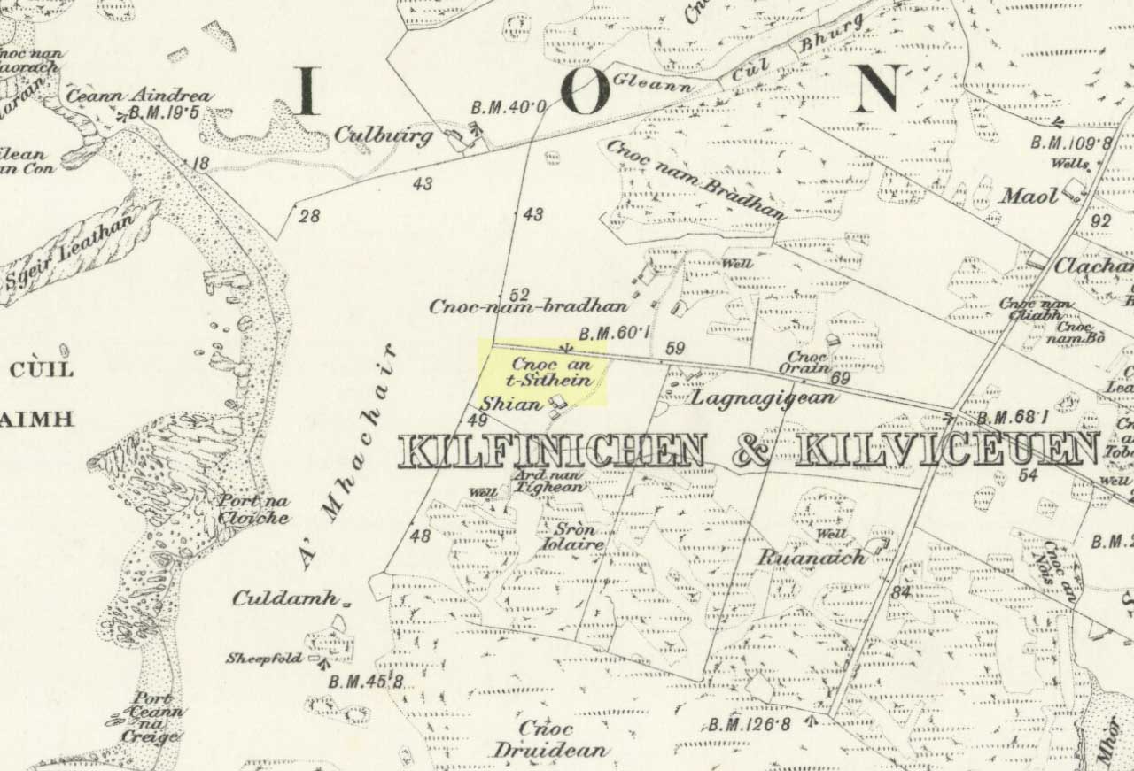
Cairn Circle (destroyed): OS Grid Reference – NM 2721 2371
Also Known as:
Angel Hill
Cnoc nar-aimgeal
Sithean More
Archaeology & History
There have long been rumours of stone circles on the druid’s isle of Iona, but many are dismissed as little more than errors on behalf of antiquarians, or false descriptions of hut circles and settlement remains. The stone circle of Sithean Mor however, does seem to have existed until only a century or two ago. It was first mentioned by the great traveller, Thomas Pennant (1776), who visited Iona more than once. He told us:
“On my return I saw, on the right hand, on a small hill, a small circle of stones, and a little cairn in the middle, evidently druidical, but called the hill of the angels, Cnoc nar-aimgeal; from a tradition that the holy man had there a conference with those celestial beings soon after his arrival. Bishop Pocock informed me that the natives were accustomed to bring their horses to this circle at the feast of St. Michael, and to course round it. I conjecture that this usage originated from the custom of blessing the horses in the days of superstition, when the priest and the holy-water pot were called in: but in latter times the horses are still assembled, but the reason forgotten.”
Site of the Sithean Mor on the 1881 OS-map
The day of the “feast of St. Michael” that Pennant mentioned was our indigenous heathen New Year, or Halloween, now usurped and misrepresented by countless plastic pagans and christians alike. It would appear from Pennant’s description that the circle in question was more likely a cairn circle. The fact that the heathen islanders celebrated annual rites here at Samhain, strongly implies there was once a hero-myth and a creation myth in evidence, but I am unaware of any remaining tales that may help confirm this. The coming of St. Columba may be responsible for this lack of oral tradition.
More than a century after Pennant’s visit here, the ring of stones had been destroyed. We know this from the description given by Archie MacMillan (1898) in his fine text on the antiquities of Iona, where he said,
“Angel Hill, called in the vernacular Sithean More. There was, not so very long ago, a circle of standing stones on the top of this hillock. They have been used for other purposes.”
Folklore
The most commonly recited tale of this grassy rise is that when St. Columba brought christianity to the island, he communed here with the angels. This is a simple displacement tale: of a new faith replacing an older one. The old name of the hill, Sithean Mor, tells that the littlepeople or fairy folk once held influence here.
References:
Cumming, C.F.G., In the Hebrides, Chatto & Windus: London 1883.
MacMillan, Archibald, Iona: Its History and Antiquities, Houlston & Sons: London 1898.
Pennant, Thomas, A Tour in Scotland, 1772 – Part 1, Benjamin White: London 1776.
From the famous Dick Hudson’s pub on the south side of Ilkley Moor, take the road right (east) for a half-mile until you reach the large Weecher Reservoir just off the roadside on your right. Less than 300 yards past the reservoir, a footpath takes you onto the moor itself. Walk up the path for about ⅔-mile — crossing one wall, then walking roughly parallel with another on your right — until you reach a crossing of paths where there are 2 gates or stiles. Take the lower of the two stiles, through the wall, but below the fence. You’ll see an awful Yorkshire Water cover, which has just about destroyed the once-fine well that had always flowed here. Below this, by the wallside, are the trickling remains of our old healing spring.
Archaeology & History
When I was a young boy, Horncliffe Well was the site we would visit every weekend as our first stopping-spot on our regular ventures exploring these moorlands — “from Wrose to Rombalds,” as we use to call it! The old well was always very plentiful, strong-flowing, cold and truly refreshing. It was undoubtedly the best water source on the entire Rombalds Moor region, never drying up. Even in the great droughts of 1976 and 1995, after all others had just about failed, the waters at Horncliffe were still flowing as strong as ever, as they had always done. But not anymore…
Edna Whelan’s old drawing
First described in land records of 1273 CE, this has always been a well of great repute and oral tradition told that this great old well never ran dry. It marked the ancient boundary point where the moorlands of Hawksworth, Burley and Bingley all meet. By name alone it is associated with the nearby and curious Horncliffe Circle, whose status itself is unclear (the circle seems more a place of refuge or living than a true ritual site).
Horncliffe House around 1801
The remains of old buildings on the flat just above where the waters once flowed were built in much more recent centuries. The building appears to have been started around 1799, for E.E. Dodds (1985) told that in 1800 it was used as a school for several years by local teacher Joshua Briggs. J. Horsfall Turner (1907) published a copy of an old drawing of the school, as it was soon after construction.
Horncliffe Well was dug into by the privatized water company known as Yorkshire Water (owned by rich greedy fuckers) in the 1990s, who channelled most of its endless supply away for commercial benefit. When their company was stealing the water from the moors, the workmen snapped an old markstone at its base next to the adjacent Horncliffe House (in ruins). The waters had always flowed fast and freely, but after Yorkshire Water had finished their ‘work’ here, the great majority of Horncliffe’s water supply subsided considerably, leaving walkers, birds and animals to suffer from its demise. In all sincerity, it’s to be hoped that good people someday will visit this once-fine site and return it to its previous healthy status.
Folklore
When we were kids we came here every weekend and got to know the old ranger who we’d meet either here or at the adjacent Horncliffe Circle, 250 yards NNE, where we’d sit and eat. In the mid-1970s, he told us that the old well was once a site where the fairy-folk would play, around Mayday (beltane). And though in later years I’ve sought for any information about this in all early antiquarian books that cover this area, I’ve never found any mention of this tale in print. The old ranger knew the moors and its history better than anyone I’ve ever known and many old stories died with him after his death.
References:
Bennett, Paul, The Old Stones of Elmet, Capall Bann: Chieveley 2003.
Dodd, E.E., Bingley: A Yorkshire Town through Nine Centuries, M.T.D. Rigg: Guiseley 1985.
Laurence, Alastair, A History of Menston and Hawksworth, Smith Settle: Otley 1991.
Turner, J. Horsfall, Idle Upper Chapel Burial Registers and Graveyard Inscriptions, Harrison & Son: Bingley 1907.
Whelan, Edna, The Magic and Mystery of Holy Wells, Capall Bann: Chieveley 2001.
Whelan, Edna & Taylor, Ian, Yorkshire Holy Wells and Sacred Springs, Northern Lights: Dunnington 1989.
Early photo of holy well site (Henry Taylor, 1906)
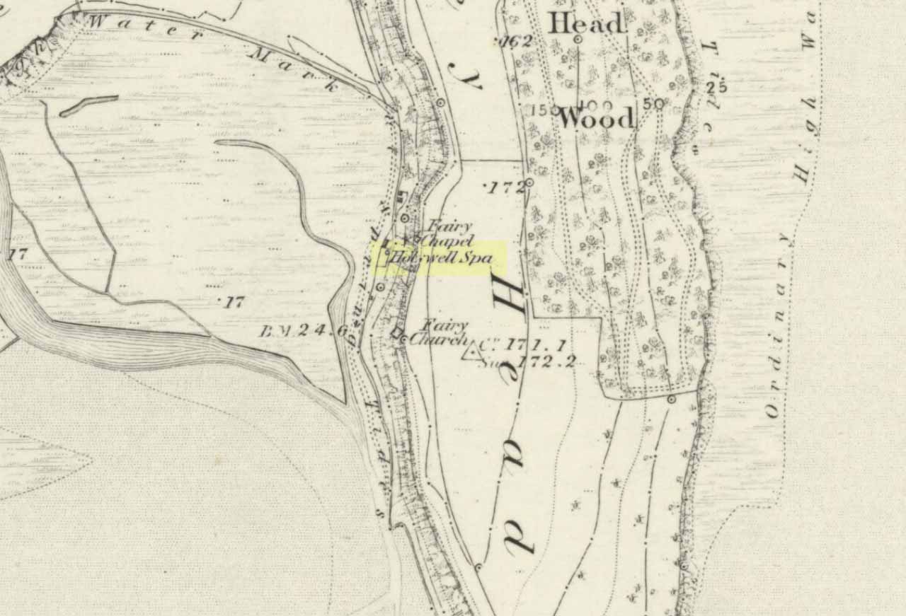
To get here you have to travel right to the end of the road, then walk a short distance until you hit the horrible coastal waters where there’s a natural rock arch. Just before here, on the west-facing side, is this famous holy well.
Archaeology & History
Just before this little-known sacred well is a cavity in the limestone rock which is called the Fairy Church, and a couple of hundred yards below here is another one which was known as the Fairy Chapel. This region was obviously of sacred importance to our ancestors – and should still be to those of us with ecological concerns. The waters from this well were said to cure poisons from the body. It was written about at some length in Mr Taylor’s (1906) superb survey, where he collated material from a series of other early tracts describing the well. He wrote:
“This celebrated medicinal well is said to have been used by lead miners from the time of the Romans. The patients come for a two or three days’ stay to “get the poison out of their systems.” The site is three and a half miles nearly due south from Cartmel. The water, which has a very peculiar taste, comes down from the hillside and flows into a small artificial basin or grotto. The key of the door is kept at a neighbouring farmhouse. Close to the well is an untenanted building formerly used by indigent sufferers. The wooded cliff forming ‘The Head’ is of singular beauty, overlooking the waters and sands of Morecambe Bay. On Hennet’s map of Lancashire (1828) the well is called ‘Spa Holy Well.’
“…Mr. W. O. Roper, in his Churches, Castles, and Ancient Halls of North Lancashire, writes: “One other appendage to the Priory of Cartmel should be mentioned, and that is the well known as the Holy Well. On the sea-shore, close under the towering cliffs of Humphrey Head, and almost immediately below the natural arch of rock which leads to the recess known as the Fairy Chapel, bubbles the well to which in former days the Priors journeyed in state from their neighbouring Priory, and to which in more recent times large numbers of people resorted, hoping to derive benefit from its medicinal qualities.”
“Mr. James Stockdale, in Annals of Cartmel, writes: “Near to this holy well (Humphrey Head) are two cavities in the mountain limestone rock called the ‘Fairy Church’ and the ‘Fairy Chapel,’ and about three hundred yards to the north there used to be another well, called ‘Pin Well’, into which in superstitious times it was thought indispensiable that all who sought healing by drinking the waters of the holy well should, on passing it, drop a pin; nor was this custom entirely given up till about the year 1804, when the Cartmel Commoners’ Enclosure Commissioners, on making a road to Rougham, covered up this ‘Pin Well’. I have myself long ago seen pins in this well, the offerings, no doubt, of the devotees of that day.”
“Mr. Hope, in his Holy Wells of England, says that “this is a brackish spring celebrated as a remedy for stone, gout, and cutaneous complaints. The water issues from a projecting rock of limestone, called Humphrey Head and its medicinal qualities occasion a considerable influx of company to Cartmel, Flookborough, Kent’s Bank and Grange during the summer months…”
Holy Well on 1851 map
The site was clearly marked in 1851 on the first OS-map of the area as the Holywell Spa, and the attendant Fairy Chapel and Fairy Church shown as two distinctly separate places, very close by.
References:
Hope, Robert Charles, Legendary Lore of the Holy Wells of England, Elliott Stock: London 1893.
Taylor, Henry, The Ancient Crosses and Holy Wells of Lancashire, Sherratt & Hughes: Manchester 1906.
Follow the same directions to reach the superb Badger Stone carving, and from here take the footpath that runs downhill. You’ll cross another footpath about 100 yards down the moor, but just keep walking down the path and you’ll notice the small copse of woods ahead of you. As the footpath begins to swerve roughly away, northeast, heading away from the said woodland, keep your eyes peeled on your left for a reasonably large but flattish rock close to the ground (in summer it’s surrounded by bracken) about 75 yards away. That’s your target!
Archaeology & History
Of the hundreds of cup-and-ring stones on Ilkley Moor and district, this is one of my personal favourites! I first visited the stone in 1977 as a young teenager and was mightily impressed by the unusual nature of the design here — and that impression still remains. Aswell as possessing the usual cups and rings, the Barmishaw Stone is one of just a few rocks also possessing a sort of ‘ladder’ design or linear pattern within the overall carving: an insignia echoed on the nearby Willie Hall Wood carving, the Piper Stone, and also on the Panorama Stones. As with the ‘ladders’ on the Panorama carving, those found here at Barmishaw are very eroded and are increasingly difficult to see during the daytime (the best time to notice them is usually around sunrise or sunset, and particularly when the rock itself is wet).
The carving has been described many times, albeit briefly, by a number of writers. In John Hedges (1986) fine survey he said the following:
“Medium sized flat-topped rock…fairly smooth grit, sloping slightly east to west, covered with carvings, some of which are very worn. Slanting sunshine needed to detect them. About twenty-four cups, at least nine with rings or incomplete rings, two with multiple grooves half round and continuing straight down, one of them incorporating ‘ladder.’ Five other ‘ladders’ – in a good light. Cups mostly deep and clear.” A few years later, Boughey & Vickerman (2003) echoed much of Mr Hedges description, though noted that of the 24 cups with their rings, one possessed a triple ring.
Alan Davies’ illustration
Like so many cup-and-ring stones, they have given rise to hosts of fascinating theories and ideas — one of which is based on mathematics and metrology. In the 1980s, Alan Davies (1983, 1988) surveyed the Barmishaw Stone — and other carvings on Ilkley Moor — to explore the possibility that the cups and rings were laid out according to a basic unit of measure, the Megalithic Inch (MI), as proposed by Alexander Thom some years earlier. Although Davies’ work showed that such a primary unit of measure wasn’t to be found universally, his research at the Barmishaw Stone indicated “significant evidence for quanta of…3 MI,” although this occurred “when the analysis is restricted to only ringed cups.” Despite this, Davies thought that the existence of the Megalithic Inch was evident in this and other carvings on the moors, stating that:
“The repeated emergence of the significance of ringed cups, and the fact that all putative quanta seem to bear a simple numeric relation to each other do not seem to be coincidental.”
Although it has to be said that the selectivity of data in Davies’ research is more indicative that the Megalithic Inches in the the carvings was due, neither to chance nor mathematics, but more that the implements used to carve the rocks and the size of the hands of the people doing the carvings was pretty uniform and so, as a result, would give an obvious window of numeric similarities that can easily be mistaken as a deliberate metrology. These simplistic factors need assessing. In modern trials that we’ve done carving cup-markings, we’ve found them to be of similar size to those carved in prehistoric times—as you’d expect.
Barmishaw Stone (after Hedges, 1986)Barmishaw stone (Cowling 1946)
The ladder motif central to this carving may have related to early religious and ritual events here. Across the world, indigenous cultures commonly relate the ‘ladder’ to be a symbol of ascension, both by shamans, mystics and during rites of passage. The symbol represents the journey of the soul to and from supernatural realms. To discount this possibility at the Barmishaw Stone would be shortsighted.
The carving was very probably painted when our neolithic ancestors gathered here, much as Australian aborigines still do to their carvings using lichens and other plant dyes, with the respective ladders and lines changing colour where movements between worlds or shifts of attendant spirit occurred. By virtue of the its very name, I consider this rock to have been considerably important; the “ghost” aspect to barmishaw being a typically misconstrued aspect of ‘spirit’.
Folklore
This excellent cup-and-ring marked stone probably derives its name from the old dialect words “barm i’ t’ shaw”, meaning “ghost in the wood” stone. Whatever guise the attendant spirit of this rock may have had has long since been forgotten; though spectral accounts from the beginning of the nineteenth century until modern times may give us clues. There have been several reports of green-coloured elemental creatures around the area between here and the White Wells sacred spring a short distance to the east. The most recent account, from 1987, took on the modern mythic form of a little green man from space, with attendant UFO to boot! The Barmishaw Hole nearby was a place where faerie-folk used to live. Excesses of geological faulting and water makes the magickal nature of this place particularly potent.
References:
Allen, J. Romilly, “The Prehistoric Rock Sculptures of Ilkley,” in Journal of the British Archaeological Association, volume 35, 1879.
Allen, J. Romilly, “Notice of Sculptured Rocks near Ilkley,” in Journal of the British Archaeological Association, volume 38, 1882.
Bennett, Paul, “Cup-and-Ring Art”, in Towards 2012, volume 4, pp.83-92, 1998.
Bennett, Paul, The Old Stones of Elmet, Capall Bann: Milverton 2001.
Boughey, Keith & Vickerman, E.A., Prehistoric Rock Art of the West Riding, WYAS: Wakefield 2003.
Cowling, E.T., ‘A Classification of West Yorkshire Cup and Ring Stones,’ in Yorkshire Archaeological Journal 1940.
Cowling, E.T., Rombald’s Way: A Prehistory of Mid-Wharfedale, William Walker: Otley 1946.
Davis, Alan, ‘The Metrology of Cup & Ring Carvings near Ilkley in Yorkshire,’ Science Journal 25, 1983.
Davies, Alan, ‘The Metrology of Cup and Ring Carvings,’ in Ruggles, C., Records in Stone, Cambridge University Press 1988.
Eliade, Mircea, Patterns in Comparative Religion, Sheed & Ward: London 1958.
Hedges, John (ed.), The Carved Rocks on Rombalds Moor, WYMCC: Wakefield 1986.
Wright, Joseph, The English Dialect Dictionary – volume 1, Henry Frowde: Oxford 1905.
John Dixon took a bunch of us on a pleasant amble here via the Fair Oak Circle site. From Fair Oak, go round the back of the farm and past the small cluster of hidden cottages, then bear right down the dirt-track and up the slope, then cross the field in front of you, going over the stile, following the footpath round the eastern edge of the slightly limestone New Laund Hill, and down again, thru the gate. From here, head diagonally across the field 150 yards towards the fencing at the woodland edge. Over the fence, into the trees, head halfway down the steep-ish slope and keep your eyes peeled for the rocky outcrop nearly halfway down. Alternatively, an easier way here is apparently from the Inn at Whitewell. Go across the river via the stepping stones (or wade!) and follow the footpath uphill towards a farm, where you’ll find a large steel gate on the left that leads into the woods. Here there are 2 paths: follow the higher of the two until it starts bearing to the right. Once here, look up the hill to the right you’ll see the rock outcrop. The caves are there!
Archaeology & History
Smaller Fairy Hole
There are at least 3 caves here, close to each other along the edge of the small footpath a few yards apart. The small rounded entrance of the northernmost one (photo, right) is reported by English Heritage to have had no human remains found therein, but further investigation is required here. The main cave however is where intriguing prehistoric finds were located. It appears that the entrance was deliberately built-up and blocked by stone walling a few yards inwards, giving the remains found therein a state of protection and sanctity. Writer and historian John Dixon (2004) tells what was in the cave:
“In 1946, an excavation was carried out on the site by the archaeologist Reginald C. Musson. In front of the larger cave is a flat platform on which evidence of Bronze Age daily life was found. This included animal bones, a pebble pounder (used to extract marrow from bones) and shards of a food vessel.
“All that survived of this tripartite collared urn was a large rim-collar shard, two fragments displaying neck/shoulder/body elements and five smaller pieces, probably from the base of the body. This is the only collared urn to have been found in a cave in Lancashire. Its tripartite Pennine form assigns it to an early Bronze Age date.”
The main Fairy HolePlan of cave chamber (after J.Dixon 2004)
The artificial walled entrance may not merely have been an ingredient giving sanctity to the place, but this could well have been a site for ritual shamanic practices, including prolonged rites of passage and death rituals (authentic ones, not the modern pagan nonsense). The ‘ritual death’ elements are highly probable here for, as John Michell (1975) told, caverns and crevasses are “most responsive to the necromancer’s invocation”. It’s geomancy, spirit association and the archaeological finds therein are strongly suggestive of this usage. (Eliade 1989, 1995; Maringer 1960, etc) Bearing this in mind, it is of some concern regarding the individual who thought it wise to spray-paint his name against the wall of the cave entrance (see photo); for many are those even in these days of shallow minds who fall prey to the car-crashes and creeping madness brought upon themselves by desecrating ancestral sites of ritual magick. It would be intriguing to keep a prolonged eye on the ‘Forsh’ who painted his ego in this cave of dead spirits…
Folklore
Not surprisingly, the little people hold legend here. Jessica Lofthouse (1946) found tales of these ancient peoples in several places close by, but at the Fairy Caves specifically,
“everyone knew that these little caves in the limestone at Whitewell were the homes of the little folk.”
…And in relation to the ingredient mentioned above, about ritual use of the cave in ancient times: are there any serious ritual magickians who’ve spent time working in this cave, overnight or longer, and who can let us know of their encounters here? (long shot, I know – but it’s worth asking, considering the probable use of the place) Or perhaps spontaneous encounters of other people here…
Chambered Cairn (destroyed): OS Grid Reference – SJ 266 223
Also Known as:
Llanymynych Hill
Llech y Wydhon
Scruffy 1835 ground plan of the lost tomb
Archaeology & History
An exact grid-reference for this once-impressive chambered tomb is difficult as “nothing remains of this site at the present day” (Daniel 1950) and the majority of the hilltop itself (a prehistoric hillfort no less), has been turned into one of those awful golf courses which are still spreading like cancer over our ancient hills. It was obviously very close to the Shropshire border, as the folklorist Charlotte Burne (1853) said the grave was “on the Shropshire side of Llanymynech Hill,” perhaps placing it in the township of Pant. But traditionally it remains within Llanymynech, within and near the top of the huge hillfort and east of Offa’s Dyke.
The old tomb was mentioned in an early letter of the great druid revivalist, Edward Lhwyd, who left us with the old ground-plan, reproduced above; and based on Lhwyd’s drawing and early narratives, Glyn Daniel (1950) thought the site “was perhaps a gallery grave”. The best description we have of Bedd y Cawy was penned by John Fewtrell (1878) in his essay on the local parish in which he told:
“This interesting relic of antiquity stood on the north-eastern end of the hill. It was formed of four upright stones, on the top of which was placed a flat slab measuring 7ft by 6ft, and 18 in thickness. It is known by the name “Bedd-y-Cawr” (the Giant’s grave). The British name appears to support the theory that the cromlech is a burying place, and not an altar devoted to religious purposes. The word is derived probably from the Welsh cromen, a roof, or vault, and lech, a stone, meaning a vault formed by a slab supported upon uprights ; or, according to some, ” the inclining flat stone”. Rowlands derives it from the Hebrew cærem-luach, “a devoted stone”, but this is far-fetched for a word or name in common use among our British forefathers. Many regard the cromlech as a distinct species of monument, differing from either a dolmen or a cairn.
“When the covering of stones or earth has been removed by the improving agriculturist, the great blocks which form the monolithic skeleton of the mound and its chamber usually defy the resources at his command. As the skeleton implies the previous existence of the organised body of which it formed the framework, so, upon this theory, the existence of a ‘ cromlech ‘ implies the previous existence of the chambered tumulus of which it had formed the internal framework. Sepulchral tumuli were formerly classified according to their external configuration or internal construction; but more extended and critical observation has shown that mere variations of form afford no clue to the relative antiquity of the structures. But as it has always been the custom of the prehistoric races to bury with their dead objects in common use at the time of their interment, such as implements, weapons, and personal ornaments, we have in these the means of assigning the period of the deposit relatively to the Stone, Bronze, or Iron age.” Sometimes no traces whatever of human remains are found in the chamber. Search was made to some depth in this cromlech, but nothing was found.”
In Fewtrell’s same essay he also described another megalithic site (also destroyed) on the southwestern part of the Llanymynech Hill, where,
“stood two rows of flat stones, parallel, 6 feet asunder, and 36 in length. A tradition exists which states that in digging near this place a Druid’s cell was discovered, but of what shape or size it does not relate. There were a number of human bones and teeth in a state of good preservation also discovered. In digging between the parallel rows a stratum of red earth was found, about an inch thick.”
Folklore
As the name of this old tomb tells, it was once reputed as “the Grave of the Giant”, but in Charlotte Burne’s huge work on the folklore of Shropshire (volume 1), she told it to be the tomb of his lady:
‘The Giant’s Grave’ is the name given to a mound on the Shropshire side of Llanymynech Hill, where once was a cromlech, now destroyed. The story goes that a giant buried his wife there, with a golden circlet round her neck, and many a vain attempt has been made by covetous persons to find it, undeterred by the fate which tradition says overtook three brothers, who overturned the capstone of the cromlech, and were visited by sudden death immediately afterwards.”
There is also a legendary cave beneath Llanymynech Hill which have long been regarded as the above of goblins and faerie folk. More of this will be told in the profile for the hillfort itself.
References:
Burne, Charlotte Sophia (ed.), Shropshire Folk-lore, Trubner: London 1853.
Daniel, Glyn E., The Prehistoric Chamber Tombs of England and Wales, Cambridge University Press 1950.
Fewtrell, John, “Parochial History of Llanymynech,” in Collections Historical & Archaeological Relating to Montgomeryshire, volume 11, 1878.
Wynne, W.W.E., “Letters of E. Lhwyd,” in Archaeologia Cambrensis, vol.3, 1848.
The Fairy Stone, on the south-west corner of Clunbury Hill, measures some 3ft by 2 ft 3 in and is some 2ft 6 in high. Local lore tells that it was once a standing stone, but this may not be the case; it’s thought more likely to be a simple glacial erratic. The stone is granite with quartz veins and stands very close to the local boundary line.
Folklore
Local researcher Jonathon Mullard found this stone, not surprisingly, to have “had a long tradition of fairy lights associated with it; they were said to appear at certain times of year.” And Mullard found one very intriguing encounter of these supernatural forms, later narrated in Paul Devereux’s (1990) excellent tome, which told:
“The legend would seem to relate to actual folk knowledge of the site, because Mullard was informed by an elderly woman living locally that she recalled her grandfather telling of an encounter with the lights. Returning home one evening across Clunbury Hill, he saw the whole area around the stone filled with small lights of a gaseous appearance bobbing up and down a short distance above the ground. Not wanting to go out of his way, the man walked through them. He found that any lights he happened to touch against adhered to his trousers. He briskly brushed them off, but found when he got home that the fabric was scorched. The woman had actually kept the trousers up until a decade or so before talking with Mullard!”
References:
Devereux, Paul, Places of Power, Blandford: London 1990.
Standing Stone (destroyed): OS Grid Reference – TA 040 587
Archaeology & History
Information on this stone is sparse and the grid-reference cited is a close approximation of its precise location. And were it not for the records of Victorian folklorists, its existence may have been completely lost. The first reference I’ve found of it is in Nicholson’s East Yorkshire (1890) survey, but I am hoping that someone, somewhere, made archaeological notes of the site (am I hoping for too much here…?) The stone appears to have stood upon, or was very close to, the local boundary line between Nafferton and Driffield—which means there could be a record of it in any perambulation accounts of the region.
Folklore
John Nicholson (1890) told us the following intriguing bitta folklore about this stone, saying:
“About half way down the hill forming the eastern slope of Nafferton Slack, by the roadside, to prevent waggons leaving the roadway, stood a large stone, which was believed to have wonderful powers. At night, at certain seasons, it glowed like fire, sometimes it seemed but the portal of a well-lighted hall; and one old stone-breaker declared he had heard wonderful music issuing therefrom, the like of which he had never heard before; while on one occasion he had seen troops of gaily-dressed elfins repairing thither, some on foot and some on carriages, and they all went into this mysterious hall. The old man is dead, the stone is gone, and the fairies have departed.”
Some twenty years later, Mrs Gutch repeated the story, but added no further details. One wonders whether the information about a fairy hall implied the former existence of a mound or tumulus next to the old stone (a few hundred yards south, just off the same boundary line, we find the remains of the curiously named tumulus of Cheesecake Hill). Any further info would be most welcome…
References:
Gutch, Mrs E., Examples of Printed Folk-lore Concerning the East Riding of Yorkshire, David Nutt: London 1912.
Nicholson, Folk-lore of East Yorkshire, Simpkin Marshall: London 1890.


")
")


")
")
")


