Calf Hey Well, Briercliffe, Lancashire

Healing Well:  OS Grid Reference – SD 87943 34622

Getting Here

The holy well/spring can be reached by following the Worsthorne road south from Haggate to Cockden Bridge over the River Don, then following the footpath due east beside the river for about a quarter of a mile. At the Ormroyd footbridge where the River Don becomes Thursden brook head in a north-easterly direction up the hillside. The well, or what’s left of it, can be found beside a trackway.

Archaeology & History

Around twenty-five years ago Calf Hey Well was described as being a square-shaped structure made of five stone slabs, one of which makes the roof. The water, which most probably had some form of mineral content, bubbles up into the large square basin which is a little lower than ground level.  Today, the well is still there but I don’t know in what condition it is.

Folklore

According to Clifford Byrne in his book The Holy Wells and Mineral Springs of N.E.Lancashire,

“Calf Hey Well is a strong spring which rises out of the hillside, but in medieval times it was believed that the waters here had special qualities. Some people thought it was a holy well and reputedly many people visited Calf Hey on holy days when jugs of water were sold. A few accounts state that stalls were set up on a flat piece of land to the west of the well, Here vendors not only sold water but other things (food, religious objects and trinkets) and a market atmosphere must have pervaded the site”.

In 1819 the local water company took over the well and began to use its supply of water for the ever growing population of Burnley a few miles west of here. After this the fairie people were never seen again at the well – they were probably feeling very indignant at what had transpired.

Folklore has played its part here too. Fairies are said to have inhabited the well in days gone by – indeed they were often seen dancing around the well in the moonlight. These fairies or “little people” were not just creatures of the night which our ancestors delighted in when they could catch a rare glimpse of them. In fact these little people were quite normally formed although small in stature. Though not human they had the capacity to intervene in our human affairs – usually but not always for the good of it. They were known to steal little children and babies, supplanting them with their own offspring. So the parents of newly born babies had to be very vigilant and get their babies baptised as quickly as possible.

There are a few lesser-known wells in the same area as Calf Hey. These include The Jam Well at Worsthorne, Sweet Well at Holden Clough and Robin Hood’s Well at Black Clough, Thursden.

References:

  1. Byrne, Clifford, The Holy Wells and Mineral Springs of Northeast Lancashire, MS copy in Nelson Public Library (Reference).
  2. Frost, Roger., A Lancashire Township – The History of Briercliffe-with-Extwistle, Rieve Edge Press: Briercliffe 1982.

Links:

  1. Additional info on the TNA Forum

Copyright © Ray Spencer 2011


Beadle Hill, Extwistle, Lancashire

Earthworks:  OS Grid Reference – SD 8895 3420

Archaeology & History

The low hill called Beadle Hill is located about half a mile north of Swinden Reservoir between Worsthorne and Haggate in the area called Extwistle. It is just a short distance south of Monk Hall and a little east of Monk Hall farm. The earthworks are a long rectangular feature on a low hill (more of a mound really).

The earthworks are more noticeable on the south and west sides but less so at the eastern and northern edges of the mound. They can’t be said to be in any way defensive. The thinking is that this was a Romano-British farmstead or settlement from the late 4th century AD and, not as often thought a Roman camp. The name Beadle is apparently from the Anglo-Saxon/Old English word ‘Beado‘ or ‘Beadlo‘, meaning ‘battle.’  So could the hill be the site of some long forgotten skirmish from the time when the Romans were leaving the north of England? Or could it refer to the legendary ‘Battle of Brunanburh’ which was fought close by in 937 AD?  In that battle King Athelstan fought against, and defeated, the Danes and Scots who were moving south from Northumbria.

At the south side of Beadle Hill there is an ancient spring, and to the east is Twist Castle—a circular earthwork that could date from the same period as Beadle Hill.  Also, there are a number of tumuli and cairns in this area though these are prehistoric in date, probably Neolithic or Bronze-Age. I do not know whether the site has been excavated.  If it has, please let us know!

References:

  1. Cockburn, John Henry, The Battle of Brunanburh and its Period, Elucidated by Place-Names, Sir W.C. Leng: Sheffield 1931.
  2. Frost, Roger, A Lancashire Township – The History of Briercliffe-with-Extwistle, Rieve Edge Press: Briercliffe 1982.

© Ray Spencer


Broadbank Earth Circle, Thursden, Burnley, Lancashire.

Enclosure: OS Grid Reference — SD 9024 3522

Also Known as:

  1. Burwains Enclosure
  2. Burwains Camp

Getting There

From Nelson town centre go north east towards Catlow, turning left near the Shooters Arms public house, then turn right again to the Coldwell Activity Centre.  Carry on towards Thursden Valley till you see the World War 2 pillbox on the right.  Here turn right and after 300 yards a picnic site and carparking area is reached along the Briercliffe road. On the opposite side of the road over a wall and barbed wire is Broadbank Earth Circle, though unfortunately there is not much to see there today. 

Archaeology

First excavated in 1950 by the Archaeology Department of Liverpool University and again in the 1960s, the earthworks here stand at 1,147 feet above sea-level (350m). The site comprises of an earth circle 150 feet (46m) in diameter which encloses an inner ditch 1 foot (30.5cm) deep and 10 inches (25.4cm) across. The bank was composed of boulder clay thrown out from the ditch. A hearth was found below the bank at the eastern end.  Some rough flint and chert flakes were also found together with a stone axe of Langdale origin. This is four-and-half inches or 11.4cm wide.  It has a curved cutting edge and a thin rounded head. Its surface is ground smooth but there is no evidence of polishing.

The earthworks at Broadbank have suffered through farming activity over many centuries and the earthen circle is now difficult to see at ground level, though the inner ditch is still visible. The low hillside or, what look like ramparts, at the northern end by the pillbox are probably not in any way connected, though this low bank may have added to the building of the bank. Archaeologists consider the site to be of Iron Age origin.

References:

  1. Liverpool University Archeology Department, Report and pamphlet, 1950.
  2. Powell, J.G.E., “Excavations of a Circular Enclosure at Broadbank, Briercliffe, Lancs,” in Transactions of the Historical Society of Lancashire & Cheshire, 104, 145-151.

Copyright © Ray Spencer, The Northern Antiquarian 2011


Delf Hill, Extwistle, Burnley, Lancashire

Ring Cairn:  OS Grid Reference – SD 9006 3373

Also Known as:

  1. Delph Hill Pasture

Archaeology & History

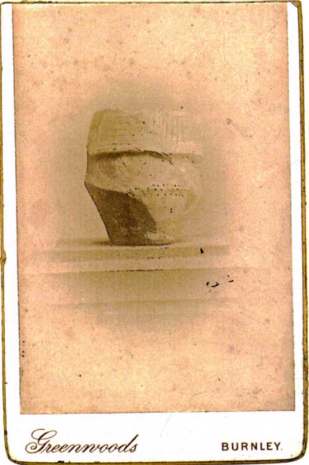
Rare 1842 photo of urn from Delf Hill

Described in Walter Bennett’s (1946) magnum opus as a “stone circle” and repeated in Aubrey Burl’s (2000) magnum opus under the same category, the site here seems more likely to have been an old cairn circle, or perhaps even a simple tumulus — and a small one at that!  It was first noted in June of 1842 when the antiquarian, Mr F.C. Spencer of Halifax, “had his attention called to a circle of stones in a field called Delph Hill Pasture by Jonas Lee, a Thursden farmer, and a somewhat noted character in his day” who knew the location very well. It didn’t take long for Mr Spencer to realise that this was “an ancient British barrow,” as he called it, and made plans to excavate the site soon after seeing it.

Following Spencer’s dig, a short account of the finds was made in the Gentleman’s Magazine, telling of the remains of this “small circle of stones” and the burials therein.  The account said:

“The circle originally consisted of rock pillars (five of which remain) , standing about 18 inches above the surface, and being about 2 feet square.  The diameter of the circle is about 5 yards.  Mr Spencer directed an excavation to be made without delay, the result of which was the discovery of two very antique earthen urns, curiously marked, containing fragments of human bones, of small dimensions, mixed with charcoal and black mould.  The tops of the vessels were covered with small flat slate-stones, but little larger than the urns, over which larger heavy stones were placed for their protection.   The urns were found about 2 feet beneath the surface of the field, in the centre of the circle, embedded in soft clay, with many pieces of charcoal interspersed.  About 300 yards from the barrow are the bold remains of a British circular camp…”

A few years later, Tattersall Wilkinson (1893) told that “three unglazed urns, with human remains and flint arrowheads” (my italics) were found at the locale.  Curiously there has been some confusion as to the number of urns that were actually found at Delf Hill by different authors over the last 175 years (numbering between 1 and 3, depending on whose account you read!), but it would seem this has occurred due to the proximity of other tombs close by.

An excursion to Delf Hill a few years after Spencer’s first dig is described in an article by L. Clement (1874), where several members of a local history society reported that the mound here consisted of a “small circle of stones, seven in number, fourteen feet in diameter”, that probably surrounded the hillock.  One of the stones had been knocked over and moved, so the group took it upon themselves to place the monolith back into what they thought was its original setting within the monument.

References:

  1. Abraham, John Harris, Hidden Prehistory around the North West, Kindle 2012.
  2. Barnes, Bernard, Man and the Changing Landscape, Merseyside County Council 1982.
  3. Bennett, Walter, History of Burnley – volume 1, Burnley Corporation 1946.
  4. Booth, Thomas, Ancient Grave Mounds on the Slopes of the Pennine Range, R. Chambers: Todmorden 1899.
  5. Burl, Aubrey, The Stone Circles of Britain, Ireland and Britanny, Yale University Press 2000.
  6. Clement, L., “Roman Remains in Marsden, Briercliffe and Extwistle,” in Transactions of the Burnley Literary & Scientific Club, volume 1, 1874.
  7. Gomme, George Laurence, The Gentleman’s Magazine Library: Archaeology – Part 1, Houghton, Mifflin & Co.: Boston 1886.
  8. Watson, Geoffrey G., Early Man in the Halifax District, HSS: Halifax 1952.
  9. Wilkinson, Tattersall, “Extwistle Moor, Burnley,” in Transactions of the Lancashire & Cheshire Antiquarian Society, volume 11, 1893.

© Paul Bennett, The Northern Antiquarian


Cliviger Laithe, Worsthorne, Lancashire

Tumulus (destroyed):  OS Grid Reference – SD 866 309

Archaeology & History

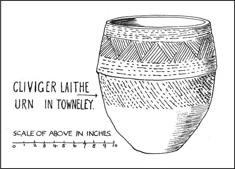
Cliviger Laithe urn

The grid reference given here is an approximation as we don’t have the exact position of the tomb that could once be seen in the fields immediately south of Cliviger Laithe farm — but it’s a pretty good approximation!  Overlooking the once proud cairn of Cliviger Law some 800 yards below to the southeast, Geoffrey Watson (1952) told us the site was “on the summit of the hill…which tailed off near Barcroft Hall,” but this area of the fields have been dug and quarried away in recent years, leaving no trace of the original tumulus that stood here.  It also appears that the discovery of the site was quite an accident, Mr Booth (1899) telling us how the urns that were unearthed here were located “while some men were engaged in digging there.”  As a result of this, we have little by way of description of the burial mound itself, but thankfully the prehistoric vase which they unearthed was kept intact.  Of this artifact Mr Booth told:

“The vase came into the possession of a Mr Roberts…who lived at the old hall near the church at Worsthorne… By the kind permission of Mr Roberts I had an opportunity of making an examination of the interesting object.  The urn itself was of a similar character to those already found in our locality* and measured 14 inches in depth, about 8 inches across the mouth, and 36 inches in circumference at its widest part… The vase “bulged” out in the middle, as these cinerary urns invariably do, and from thence it tapered down to a base of about 3 or 4 inches in diameter.  It was ornamented at the top by the usual deep collar of about 5 inches in depth, the upper and lower edges of which were ornamented (with) encircling lines… The vase contained a large quantity of calcined human bones.  Dr Dean gave as his opinion that there were the remains of two if not three human bodies, one of which was the body of a child… Besides the bones, the vases contained a quantity of charcoal and ashes, and also a very friable bone pin.”

The tomb evidently made a good enough impression on the Lancashire historian J.F. Tattersall as he took to writing a poem about the place!  It went:

In this lone cairn upon the mountain head,
On one far morning of the misty past,
The earliest wanderers o’er these moorlands cast
A kinsman’s ashes to their narrow bed.
Now we, by Nature’s kindly guidance led
By marvellous ways, through revolutions vast
Of Time, her latest children, not the last,
Gather again around the ancient dead.

References:

  1. Bennett, Walter, The History of Burnley – volume 1, Burnley County Council 1946.
  2. Booth, Thomas, Ancient Grave Mounds on the Slopes of the Pennine Range, R. Chambers: Todmorden 1899.
  3. Watson, Geoffrey G., Early Man in the Halifax District, Halifax Scientific Society 1952.

* see the Catlow urn for example

© Paul Bennett, The Northern Antiquarian