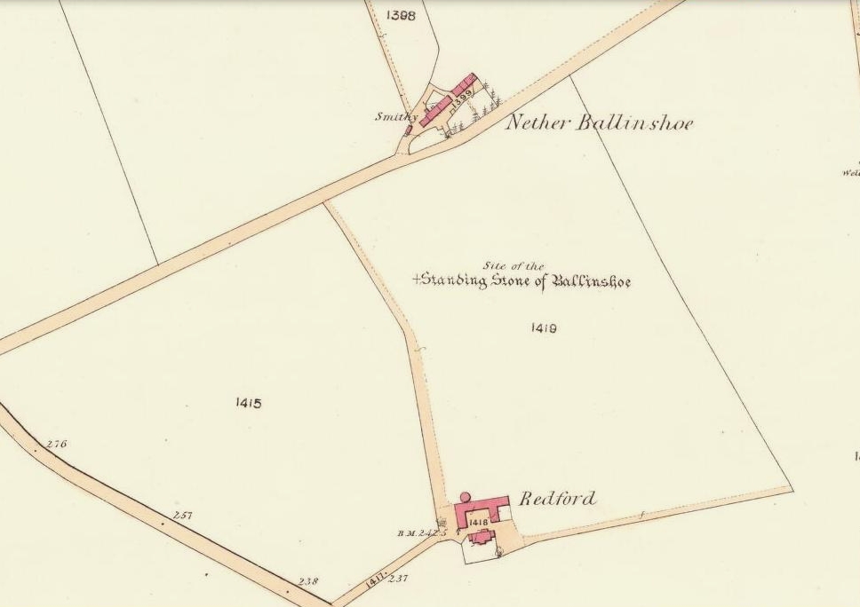
Bull Spring, Staining, Poulton-le-Fylde, Lancashire

Sacred Well:  OS Grid Reference – SD 35569 36707

Getting Here

The boggy ground of the Bull Spring - from the site of possible cairn
The boggy ground of the Bull Spring – from the site of possible cairn

To get here, leave Staining village along Mill Lane, turning right at the windmill along Smithy Lane.  Walk along Smithy Lane, then 2-300 yards past a derelict piggery on the left go into the gated trackway on the right, and Bull Meadow is to the south-east, a boggy area at the western end of OS parcel 356.  Be prepared to cross barbed wire fences.

Archaeology & History

Like the Staining Wrangdomwell or Fairy Spring recorded elsewhere, knowledge of this site owes its historical survival to the writings of Blackpool cleric, Rev. William Thornber (1803 – 1885), who wrote in 1851 about the now forgotton ‘Teanla’ or Hallowe’en bonfire cairns of Hardhorn:

“…but here adjoining the cairns are attached two wells, the one celebrated as Fairy or Wrangdomwell, and the other, issuing from a huge oblong mound of stones, as Bel spring or vulgarly Bull spring, in the Bull meadows, evidently bearing the same name as Beltain Meadow in Blackpool.  Here on this Hardhorn oblong cairn, ceremonies were observed for the purpose of obtaining health to the herds of the farmers of the township – to free the wheat-land from tares, weed &c. – to bring good luck to the votaries, and to enquire into the secrets of futurity.

The ceremony was thus:- first, large fires were lighted, two or three families joining at a circular cairn, the ashes of which were carefully collected. Then the white stones, which at first, had circled the fire were thrown into the ashes, and being left all night, were sought with anxious care at sunrise, when the person who could not distinguish his own particular boulder was considered fey, i.e. some misfortune would happen to him, during the course of the ensuing year¹.

As a finale, the stones recognised were thrown, as an offering, on the oblong cairn to the god or saint who presided over it, and the well, and thus, such collections were made in a succession of years, as to astonish the curious. The water of the wells also had a sovereign virtue for healing the disease of men and cattle….”

The healing procedure at the wells is transcribed in the description of the nearby Fairy Well. Mr Thornber continues:

“The site of the large circular cairn (at Bull Meadow) is not now easily to be distinguished, since Mr. Fisher, the proprietor of the field, has carted away upwards of twenty loads of the refuse that composed it, but the soil around it is burnt red and black. This farce was carried on in its pristine glory long after the reformation; for rational Christianity (sic), which had been almost lost previously, progressed but slowly in the district of the Fylde. Even the waters of Marton Mere (SW of Bull Meadow),…were held sacred.”

Perusal was made of the Schedule to the 1839 Tithe map which revealed a ‘Bull Meadow’, owned and occupied by William Fisher, and from this, its location was able to be identified on the OS map.

Possible source of the waters

Like Wrangdom Well, half a mile to the north-west, the Bull Spring issues from an area of swampy ground, and the exact place of issue was hard to pinpoint when this writer visited in December (see photo the right).  The oblong cairn—if indeed that is what it is—can still be identified, about 2 feet above the marsh, it is firm to stand on but not easy to distinguish owing to the amount of vegetation.

¹ Writing in the January 1883 edition of the The Folk-lore Journal, the Reverend Walter Gregor describes ‘ristin the halla-fire’ a broadly similar Scottish ritual carried on in the Fraserburgh area up to the late 18th century.

References:

  1. Thornber, William, ‘Traces of the Britons, Saxons and Danes in the Foreland of the Fylde,’ in Proceedings and Papers of the Historic Society of Lancashire and Cheshire, Liverpool 1852.
  2. Tithe Map & Schedule Transcript – ‘The Township of Hardhorn with Newton’ Surveyed by Thomas Hull in 1838, with Schedule dated 1839.’

Acknowledgement:  My thanks to the staff of the Local Studies Department, Borough of Blackpool Library Services for their assistance.

© Paul T. Hornby, The Northern Antiquarian


Fairy Well, Staining, Poulton-le-Fylde, Lancashire

Sacred Well:  OS Grid Reference – SD 34908 37119

Also Known as:

  1. Wrangdom Well

Getting Here

The site of the Fairy Well, Staining

One and a half centuries of neglect have not been kind to the Wrangdomwell, which is now in the middle of a large area of swampy land, reached from Staining village along Mill Lane, turning right at the windmill then walking along Smithy Lane.  Just before a derelict piggery on the left go into the field, and Wrong Well Meadow is on the right at the back of the piggery, with the spring issuing from the boggy ground. Be prepared to cross barbed wire fences, and to meet some friendly ponies.

Archaeology & History
Were it not for the researches and writings of an eccentric cleric, this site would almost certainly now be lost to history.  The Reverend William Thornber recorded, in his 1837 History of Blackpool that:

“The fairies of our fathers…were kind good natured creatures, at times seeking the assistance of mortals, and in return liberally rewarding them. They had a favourite spot between Hardhorn and Staining, at a cold spring of water, called Fairies’ Well to this day.”

The legendary waters hide in the rushes

Writing in a paper published in 1851, Thornber described the Fairy Well or Wrangdomwell in the context of the “Teanlas”, the enormous Hallowe’en bonfires (4) that were still at that time being lit at ritual cairns of stones in parts of west Lancashire.  One of these fire cairns once adjoined the Fairy Well, which in 1850 was still being visited for its,

“sovereign virtue for healing the diseases of men and cattle.  To succeed in obtaining a cure, the patient, escorted by his friends, was made to pass through the cairn, then he was sprinkled or dipped in the well, and lastly, he made an offering of a shell, pin, a rusty nail or a rag, but principally three white stones burnt in the Teanla fire. It is surprising in what numbers pieces of iron may be picked up. I have found since the meadows were ploughed, nails, an old shaped knife, leather thongs etc.”

Thornber wrote that the cairn no longer existed, and gave no precise location for the well.

Looking at the area between Hardhorn and Staining on the 1891 25″ OS map revealed only one ‘spring’; in land parcel 295. This parcel of land is recorded in the Schedule to the 1839 Tithe map as ‘Wrong Well Meadow’, occupied by Thomas Dobson, and owned by ‘School of Marton’, a charitable endowment established in 1717.  Adjoining Wrong Well Meadow are Old Meadow and Nickers Meadow (‘Old Nick’?), which might appear to show the Wrangdomwell as in the past having been part of a larger heathen ritual locality. Notwithstanding this, the Church was happy to take its tithe.

References:

  1. Thornber, William, The History of Blackpool, Smith Market Place: Poulton-le-Fylde 1837 (republished in 1985 by the Blackpool and Fylde Historical Society).
  2. Thornber, William, ‘Traces of the Britons, Saxons and Danes in the Foreland of the Fylde,’ in Proceedings and Papers of the Historic Society of Lancashire and Cheshire, Liverpool 1852.
  3. Tithe Map & Schedule Transcript, ‘The Township of Hardhorn with Newton’ Surveyed by Thomas Hull in 1838, with Schedule dated 1839.’
  4. Michelle Harris & Brian Hughes, in their ‘The History of the Wyre from Harold the Elk to Cardinal Allen‘ (4th ed. 2007) p35, write – “According to Tom C. Smith’s ‘History of the Parish of Chipping‘ published in 1891: ‘Teanlaes was the name given to fire celebrations, observed until quite recent years on May 1st, Midsummer Day, August 31st, and November 1st.’ These dates, it should be said, are at variance with Henry Taylor who, in his 1899 publication ‘Ancient Crosses of Lancashire’, quotes Atticus as saying: ‘The ceremony observed on Teanlow night, the last night of October, consisted of making bonfires on all the neighbouring hills.'”

AcknowledgementsMy thanks to the staff of the Local Studies Department, Borough of Blackpool Library Services for their assistance.

© Paul T. Hornby, The Northern Antiquarian


Fairy Knowe, Gairneybank, Kinross, Kinross-shire

Tumulus (destroyed):  OS Grid Reference – NT 1230 9874

Also Known as:

  1. Canmore ID 51067
1856 OS-map, showing "site of" the old tumulus
1856 OS-map, showing “site of” the old tumulus

Archaeology & History

This is one of two sites in the county of Kinross-shire that were known as the ‘Fairy Knowe’, both of which have been destroyed through uncaring agriculture practices.  Very little is known about it.  The place was described in a lengthy footnote in the Old Statistical Account of Scotland (volume 6), which told us that,

“a tumulus or mound, composed mostly of earth, with some stones intermixed, on the east of Annofreuch, was opened a few years ago and a coffin found therein formed of rough flat stones, set on edge at the sides and ends, and a large one above; within which were some bones and many pieces of burnt wood interspersed.  In the memory of some old people, it was called the Elf-hillock, but is now known by the name of the Fairyknow.”

The site was listed in the Royal Commission (1933) archaeological county survey, but with no further details.

Folklore

Although the site was a resort of the little people, or faerie-folk, we have no extant tales telling us anything more.

References:

  1. Royal Commission on the Ancient & Historical Monuments, Scotland, Inventory of Monuments and Constructions in the Counties of Fife, Kinross and Clackmannan, HMSO: Edinburgh 1933.

© Paul Bennett, The Northern Antiquarian

St. Palladius’ Footprint, Camusvrachan, Glen Lyon, Perthshire

Legendary Stone:  OS Grid Reference – NN 62626 47685

Also Known as:

  1. Craig Dianaidh
  2. Rock of Safety

Getting Here

The rocky cairn of St. Palladius

From Fortingall, get to the standing stone of Adamnan’s Cross a few miles down the stunning Glen Lyon.  Barely 100 yards before you reach the stone, notice the overgrown gorse-covered rocky rise across the road, just past Craigianie Farm.  As you climb to the top of this small rocky rise, you’ll see a cairn of stones on its top.  Just below it, into the solid rock, you’ll see a footprint-shaped hollow etched into the stone.  If it seems hidden, just keep looking – you’ll find it…

Archaeology & History

St. Palladius Stone, Glen Lyon

When Ratcliffe Barnatt (1944) visited Glen Lyon in the 1940s, this legendary rock was one of his stopping points.  “When we have passed by Ruskich and Slatich,” he wrote, “we come to that sacred spot, Craig Dianaidh, the Rock of Safety, where, until about 1480, solemn and judicial meetings were held.”  The old rock was known through recent ages, “as a preaching hill, a motehill and a justiciary court,” said Hilary Wheater (1981), and upon its top is the curious ‘footprint’ which Nature’s blood would fill on all but the hottest of summers.  It is this geological feature that gave the stone is name, long ago.

Of known historical events here, Wheater further told:

“It was on this rock…that the Baron Courts of Glenlyon were held.  Law and order was kept by regular courts held by the Chief or Landowner. The Baron-Bailiary of each area was appointed by Royal Charter.  Fifteen men were chosen as a jury and the laird or his baile presided.  To this court were brought all the problems and grievances of the people.  Here the miller accused several men of refusing to take part in the compulsory ‘hamganging’ of a new millstone; here a man was fined for brewing ale without a license; here a neighbour was accused of putting the ‘evil eye’ on the cow of the croft next door so it produced no milk; and here a man was prosecuted for ‘taking of ane sore horse of his to Rannoch in the summer of 1629 and putting on him ane great burder of timber, and letting him go through the wood where he stuck between two trees all night and the timber on his back.’  However, he was acquitted when he was able to prove that the horse was fit enough after this for another man to be able to take it to Edinburgh soon after.”

St Palladius Footprint

As well as being a moot site, it is more than probable that this footprint, like the one near the top of Dunadd in Argyll—and others scattering the Highlands and beyond—was an initiation stone, perhaps for local tribal elders or ancient kings.  Janet Bord (2004) writes about them as places of ritual inauguration in her survey of such places.

Folklore

The legendary site, looking south

This legendary rock would probably have had earlier mythic association than the one ascribing it to St. Palladius—but as yet I have found no written lore telling the nature of such a spirit, so would only perhaps discern the original genius loci by lengthy encounters with the rock in question, through mist and storm and wintry months, alone.  It is known in local folklore that Palladius was in fact an urisk: a solitary spirit of steep streams that few humans encounter due to their lonely habits amidst hidden abodes in dark and ancient gorges.  Such urisks dwelt in numbers amongst many of the steep falls in this landscape — and still do, if the words of old locals are to be believed. Here,

“St Palladius was a goblin saint, an urisk that dwelt in a mountain burn and was sanctified by the people.”

…and some rocks by the stream up the mountain immediately above this “footprint” was one of the places the urisk was known to dwell.

…to be continued…

References:

  1. Barnatt, T. Ratcliffe, The Road to Rannoch and the Summer Isles, John Grant: Edinburgh 1944.
  2. Bord, Janet, Footprints in Stone, Heart of Albion Press 2004.
  3. Fraser, Duncan, Highland Perthshire, Standard Press: Montrose 1969.
  4. Wheater, Hilary, Aberfeldy to Glenlyon, Appin Publications: Aberfeldy 1981.

© Paul Bennett, The Northern Antiquarian


Maiden’s Well, Glendevon, Perthshire

Healing Well: OS Grid Reference – NN 9703 0139

Also Known as:

1. Maiden Well

Maidens Well on 1866 map

Getting Here

Follow the same directions as if you’re going to the Maiden Castle fairy hill.  About 100 yards before reaching the hill, on the right-hand side of the footpath between the tree-line and the small stream, you’ll see a small pool of water. This is Maiden’s Well.

Archaeology & History

Maiden's Well - and the fairy haunt of Maiden Castle hill behind
Maiden’s Well – and the fairy haunt of Maiden Castle hill behind

A mile northeast of the faerie-haunted Butter Well, just on the border of Clackmannanshire and Perthshire, we find this little-known magickal spring.  More than a century ago, the story of this remote well was heard about hundreds of miles away by one Rev. Andrew Clark of Oxford, “who heard it from the late sexton of the parish of Dollar, in the county of Clackmannan” and who then mentioned its existence to the great Victorian Celtic scholar John Rhys (1901), who subsequently wrote of it as being “a fine spring bordered with flat stones, in the middle of a neat, turfy spot”, close to the legendary faerie hall of Maiden Castle. The well itself has now given birth to a pool whose waters, so folklore and text ascribe, always provides good clear water even in the height of summer.

The local historian Hugh Haliburton (1905) told that the well obtained its name from a princess who was held captive in Castle Campbell in the valley to the southwest, and that she was sometimes allowed out of prison by her captors, to walk to the well and drink its waters.

Folklore

This tale has been mentioned by various historians and, no doubt, has some religious relevance to the faerie lore of Maiden Castle, close by, Bruce Baillie (1998) told:

“A story associated with it states that it is haunted by the spirit of a beautiful maiden which only appears at night and, should any male attempt to kiss her, coronary thrombosis occurs.”!

The Maiden's Well pool
The Maiden’s Well pool

Earlier accounts tell of magickal rites that could be used to invoke the beautiful maiden, but once again dire consequences may befall the poor practitioner.

To this day, local people visit the well and make offerings to the spirit of the waters, as you’ll see if you come here.  Some of the remains here are very old; and a visit not long ago indicated that offerings were made even when surrounded by depths of snow in the middle of a freezing winter.

References:

  1. Baillie, Bruce, History of Dollar, DMT: Dollar 1998.
  2. Fergusson, R. Menzies, The Ochil Fairy Tales, Clackmannan District Libaries 1985.
  3. Haliburton, Hugh, Excursions in Prose and Verse, G.A. Morton: Edinburgh 1905.
  4. Rhys, John, Celtic Folklore – Welsh and Manx: volume 1, Oxford University Press 1901.
  5. Watson, Angus, The Ochils: Placenames, History, Tradition, PKDC: Perth 1995.

© Paul BennettThe Northern Antiquarian


Maiden Castle, Glendevon, Perthshire

Legendary Hill: OS Grid Reference – NN 9710 0141

Also Known as:

  1. Maiden’s Castle

Getting Here

1860 map showing Maiden Castle (and the Maiden's Well)
1860 map showing Maiden Castle (and the Maiden’s Well)

Take the small steep road uphill from the town of Dollar in Clackmannanshire towards Castle Campbell. Less than 100 yards above the small parking spot by the small white house near the top of the hill, turn to walk up the footpath on your right above the house, following the edge of the depleted forestry plantation parallel with the valley.  Cross the valley a few hundred yards up, but keep to path on the other side that stays parallel with the stream.  You’ll hit a small rocky glen a half-mile up. Walk thru it, alongside the very edge of the forest till the trees break and there’s a gap in the hills.  You’ve just walked past the Maiden’s Well and in front of you is a large natural rounded hill, which the footpath bends around. This hill is the Maiden Castle. (if you walk round this, a view into the eastern hills and a small lake opens up ahead of you)

Archaeology & History

The fairy hill of Maiden Castle

A large rounded hill marking the opening of Glenquey to the north and the Glen of Care to the south. Although ascribed in place-names old and new as a ‘castle’, there are no remains as such left here to account for this title. Angus Watson (1995) tells of the possibility of the place deriving its name from the Gaelic Creag Ingheann, or maiden crag. In Bruce Baillie’s (1998) survey of the area, in trying to give some relevance to the place-name, he points out that whilst no hillfort or cairn that might help account for the folklore (see below),

“Large-scale maps indicate a spot opposite on Hillfoot Hill as Greig’s Grave. There would seem to be something ancient here but of what nature it is, at the moment, impossible to say.”

When we visited the place yesterday, snow still covered much of the ground hereby, so we couldn’t do our usual explorations seeking for old sites (even the hut circles 100 yards away were covered over). The legendary healing waters of the Maiden’s Well are below here, by the side of the burn.

Folklore

This large rounded hillock was evidently a place of some importance in bygone days if the folktale here is anything to go by. Although the story echoes the some of the core sequences of modern ‘close encounter’ abduction events, other ingredients here tell of more arcane peasant rites that were once part of the social structure of our ancient heathen tribes:

“A piper, carrying his pipes, was crossing from Glendevon to Dollar in the grey of the evening. He crossed the Garchil (a little stream running into the Quaich), and looked at the Maiden Castle and saw only the grey hillside and heard only the wind soughing through the bent. But when he had passed beyond it, he suddenly heard a burst of lively music and turned round to look at what was causing it. And there, instead of the dark knoll which he had seen a few moments before, he beheld a great castle, with lights blaring from the windows, and heard the noise of dancing issuing from the open door. He went back somewhat incautiously to get a closer view, and a procession issuing at that moment from the Castle’s open door, he was caught up and taken into a great hall ablaze with lights, while people were dancing on the floor. He was at once asked to pipe to them and was forced to do so, but agreed to do so only for a day or two. At last getting anxious, because he knew his people would be wondering why he had not come back in the morning, as he had promised to do, he asked permission to return home. The faeries seemed to sympathise with his anxiety and promised to let him go if he played a favourite tune of his, which they seemed fond of, to their satisfaction. He played his very best. The dance went fast and furious, and at its close he was greeted with loud applause. On his release he found himself alone in the grey of the evening, beside the dark hillock, and no sound was heard save the purr of the burn and the soughing of the wind through the bent. Instead of completing his journey to Dollar, he walked hastily back to Glendevon in order to relieve his folk’s anxiety. He entered his father’s house and found no kent face there. On his protesting that he only gone away for a day or two before, and waxing loud in his bewildered talk, a grey old man was aroused from a doze beside the fire, and told how he had heard when a boy from his father that a piper had gone away to Dollar on a quiet evening, but had never been seen or heard since, nor any trace of him found. It turned out the piper had been in the ‘Castle’ for a hundred years.”

The Fortean experts John Keel (1971) and Jacques Vallee (1970) both contended, quite rightly, that some aspects of the ancient encounters related in such folklore has strong parallels to modern UFO ‘abduction’ events. In addition, Paul Devereux (1989) cites that such events occur where strong geomagnetic forces exist in proximity to rock outcrops, as found here.

There is the additional feature in these stories of the music of both faerie and pipers alike, whose revelling jigs carry the mortal out of time and, when returning back to human life, find no one recognises them.  This is a condition of some rites of passage in traditional societies, where mothers and fathers no longer recognise their child after they have been through the rituals after visiting spirit-lands and returning as adults for the first time: an element in our faerie-lore that has been overlooked in assessing the nature of these fascinating tales.

References:

  1. Baillie, Bruce, History of Dollar, DMT: Dollar 1998.
  2. Devereux, Paul, Earthlights Revelations, Blandford: London 1989.
  3. Fergusson, R. Menzies, The Ochil Fairy Tales, David Nutt 1912.
  4. Keel, John A., UFOs: Operation Trojan Horse, Souvenir Press: London 1971.
  5. Rhys, John, Celtic Folklore – Welsh and Manx: volume 1, Oxford University Press 1901.
  6. Vallee, Jacques, Passport to Magonia: From Folklore to Flying Saucers, Tandem: London 1975.
  7. Watson, Angus, The Ochils: Placenames, History, Tradition, PKDC: Perth 1995.

© Paul BennettThe Northern Antiquarian


Fairy Stone, Fourstones, Northumberland

Legendary Stone:  OS Grid Reference – NY 893 680

Archaeology & History

Thought to have been destroyed in the 19th century, folklorists and historians alike didn’t seem to be able to locate this little-known folklore relic, which is still alive and well in one of the fields by the village.  The exact nature of the stone isn’t known for certain.  Legend reputes it to have been one of the four boundary stones which gave the village its name; it was also said that they were Roman altars and the Fairy Stone was one of them, which was moved from the village boundary during the Rebellion of 1715 and placed nearer the centre.

Folklorist M.C. Balfour (1904) seemed to think that stone had gone when he wrote about it.  Writing about it in the past tense, he told,

“The Fairy Stone however, certainly had an existence, for a person, 80 years of age, remembered its situation to the south of the village, near the old road, and that it was squared, and had a square “cistern hewn out of its top,” which was called the Fairy Trough, and traditionally said to have had a pillar fixed in it.”

But when former Ley Hunter editor Paul Screeton (1982) came looking for the stone in the late 1970s, he was fortunate in coming across an old local:

“Some time ago while looking for the Fairy Stone at Fourstones…I came across a farmer who pointed it out and remarked that a few years previously when the road was widened the local lengthsman made sure it was not destroyed, though it had to be moved a short distance.”

Folklore

Of the four boundary stones surrounding the village, they were “supposed to have been formed to hold holy water,” said Balfour (1904).  But the title Fairy Stone given to one of them had this tale to account for it:

“A couple of miles or more down the South Tyne is Fourstones, so called because of four stones, said to have been Roman altars, having been used to mark its boundaries. A romantic use was made of one of these stones in the early days of “The Fifteen.” Every evening, as dusk fell, a little figure, clad in green, stole up to the ancient altar, which had been slightly hollowed out, and, taking out a packet, laid another in its place. The mysterious packets, placed there so secretly, were letters from the Jacobites of the neighbourhood to each other; and the little figure in green was a boy who acted as messenger for them. No wonder that the people of the district gave this altar the name of the ‘Fairy Stone’.”

References:

  1. Balfour, M.C., Country Folk-lore volume 4: Examples of Printed Folk-lore Concerning Northumberland, David Nutt: London 1904.
  2. Screeton, Paul, “The Long Man of Wilmington,” in The Ley Hunter, no.92, 1982.
  3. Terry, Jean F., Northumberland Yesterday and Today, Andrew Reid: Newcastle 1913.
  4. Watson, Godfrey, Northumberland Place Names, Sandhill: Morpeth 1995.

Acknowledgements:  Big thanks to Paul Screeton for the grid-reference!

© Paul BennettThe Northern Antiquarian


Calf Hey Well, Briercliffe, Lancashire

Healing Well:  OS Grid Reference – SD 87943 34622

Getting Here

The holy well/spring can be reached by following the Worsthorne road south from Haggate to Cockden Bridge over the River Don, then following the footpath due east beside the river for about a quarter of a mile. At the Ormroyd footbridge where the River Don becomes Thursden brook head in a north-easterly direction up the hillside. The well, or what’s left of it, can be found beside a trackway.

Archaeology & History

Around twenty-five years ago Calf Hey Well was described as being a square-shaped structure made of five stone slabs, one of which makes the roof. The water, which most probably had some form of mineral content, bubbles up into the large square basin which is a little lower than ground level.  Today, the well is still there but I don’t know in what condition it is.

Folklore

According to Clifford Byrne in his book The Holy Wells and Mineral Springs of N.E.Lancashire,

“Calf Hey Well is a strong spring which rises out of the hillside, but in medieval times it was believed that the waters here had special qualities. Some people thought it was a holy well and reputedly many people visited Calf Hey on holy days when jugs of water were sold. A few accounts state that stalls were set up on a flat piece of land to the west of the well, Here vendors not only sold water but other things (food, religious objects and trinkets) and a market atmosphere must have pervaded the site”.

In 1819 the local water company took over the well and began to use its supply of water for the ever growing population of Burnley a few miles west of here. After this the fairie people were never seen again at the well – they were probably feeling very indignant at what had transpired.

Folklore has played its part here too. Fairies are said to have inhabited the well in days gone by – indeed they were often seen dancing around the well in the moonlight. These fairies or “little people” were not just creatures of the night which our ancestors delighted in when they could catch a rare glimpse of them. In fact these little people were quite normally formed although small in stature. Though not human they had the capacity to intervene in our human affairs – usually but not always for the good of it. They were known to steal little children and babies, supplanting them with their own offspring. So the parents of newly born babies had to be very vigilant and get their babies baptised as quickly as possible.

There are a few lesser-known wells in the same area as Calf Hey. These include The Jam Well at Worsthorne, Sweet Well at Holden Clough and Robin Hood’s Well at Black Clough, Thursden.

References:

  1. Byrne, Clifford, The Holy Wells and Mineral Springs of Northeast Lancashire, MS copy in Nelson Public Library (Reference).
  2. Frost, Roger., A Lancashire Township – The History of Briercliffe-with-Extwistle, Rieve Edge Press: Briercliffe 1982.

Links:

  1. Additional info on the TNA Forum

Copyright © Ray Spencer 2011


Brown Law (310), Ilkley Moor, West Yorkshire

Cup-Marked Stone:  OS Grid Reference – SE 13191 46512

Also Known as:

  1. Carving no.149 (Hedges)
  2. Carving no.310 (Boughey & Vickerman)

Getting Here

Three cup-marks gently sleep

Get to the Cow & Calf Rocks, go up across the car-park as if you’re gonna go up onto the moor and walk up the steep footpath uphill to the left of the crags.  Once you get level with the crags, take the footpath bending left and walk along here for 110 yards, keeping your eyes peeled for the low smooth rock on the right of the footpath, just where another path meets it. You’ll find it.

Archaeology & History

Close-up, from above

This quiet little stone has seen better days.  Nearly destroyed a few weeks ago when the Emmerdale Farm film-crew churned up sections of the moor right over the side of this carving—but thankfully it still remains intact (you or I would have been prosecuted for such damage).* The carving is a simple one in graphic terms, comprising simply of three cup-markings, all on the southern side of the rock.  Close to several other petroglyphs (the Wray Stone is 78 yards north and several other more ornate carvings are close by), the carving was first described in the Hedges (1986) survey as a “small, low smooth grit rock sloping slightly NW to SE in crowberry, bilberry, grass and bracken. Three clear cups.”  But it has to be said, one of them is fading fast.  Let’s hope this humble little carving doesn’t fall prey to those who are gradually turning our moorlands into a park.

References:

  1. Boughey, Keith & Vickerman, E.A., Prehistoric Rock Art of the West Riding, WYAS: Leeds 2003.
  2. Hedges, John, The Carved Rocks on Rombald’s Moor, WYMCC: Wakefield 1986.
* As the footpaths on Ilkley Moor continue to be widened and paved by those who reckon they like these moors, it’s obvious that more prehistoric sites up here are gonna get damaged. It’s difficult to see what the local archaeologist or Natural England are doing to ensure that these stupid environmentally damaging schemes do not encroach on the mass of rich prehistoric sites on the moors, most of which have never been adequately assessed (the philosophy of “if we don’t know it’s there, it doesn’t matter if we destroy it” seems evident in some of those working for the local council). Before any work or structures are dug on Ilkley Moor, an archaeological assessment is, I believe, supposed to take place – but I think this ‘work’ consists merely of looking at their own limited records, without any detailed fieldwork being undertaken. But as we know from research undertaken by rock art students at TNA, CSI and elsewhere, there are still many cup-and-ring stones, cairns and archaeological features constantly being discovered on these moors that are not in the record books.

© Paul Bennett, The Northern Antiquarian


Sithean Mor, Shian, Iona

Cairn Circle (destroyed):  OS Grid Reference – NM 2721 2371

Also Known as:

  1. Angel Hill
  2. Cnoc nar-aimgeal
  3. Sithean More

Archaeology & History

There have long been rumours of stone circles on the druid’s isle of Iona, but many are dismissed as little more than errors on behalf of antiquarians, or false descriptions of hut circles and settlement remains.  The stone circle of Sithean Mor however, does seem to have existed until only a century or two ago.  It was first mentioned by the great traveller, Thomas Pennant (1776), who visited Iona more than once.  He told us:

“On my return I saw, on the right hand, on a small hill, a small circle of stones, and a little cairn in the middle, evidently druidical, but called the hill of the angels, Cnoc nar-aimgeal; from a tradition that the holy man had there a conference with those celestial beings soon after his arrival.  Bishop Pocock informed me that the natives were accustomed to bring their horses to this circle at the feast of St. Michael, and to course round it.  I conjecture that this usage originated from the custom of blessing the horses in the days of superstition, when the priest and the holy-water pot were called in: but in latter times the horses are still assembled, but the reason forgotten.”

Site of the Sithean Mor on the 1881 OS-map

The day of the “feast of St. Michael” that Pennant mentioned was our indigenous heathen New Year, or Halloween, now usurped and misrepresented by countless plastic pagans and christians alike. It would appear from Pennant’s description that the circle in question was more likely a cairn circle.  The fact that the heathen islanders celebrated annual rites here at Samhain, strongly implies there was once a hero-myth and a creation myth in evidence, but I am unaware of any remaining tales that may help confirm this.  The coming of St. Columba may be responsible for this lack of oral tradition.

More than a century after Pennant’s visit here, the ring of stones had been destroyed.  We know this from the description given by Archie MacMillan (1898) in his fine text on the antiquities of Iona, where he said,

“Angel Hill, called in the vernacular Sithean More. There was, not so very long ago, a circle of standing stones on the top of this hillock. They have been used for other purposes.”

Folklore

The most commonly recited tale of this grassy rise is that when St. Columba brought christianity to the island, he communed here with the angels.  This is a simple displacement tale: of a new faith replacing an older one. The old name of the hill, Sithean Mor, tells that the littlepeople or fairy folk once held influence here.

References:

  1. Cumming, C.F.G., In the Hebrides, Chatto & Windus: London 1883.
  2. MacMillan, Archibald, Iona: Its History and Antiquities, Houlston & Sons: London 1898.
  3. Pennant, Thomas, A Tour in Scotland, 1772 – Part 1, Benjamin White: London 1776.

© Paul Bennett, The Northern Antiquarian