A little-known multiple ringed carving was discovered a few years ago during the excavation of a prehistoric cairn just immediately east of the A701 roadside, several miles south of Broughton. The cairn itself had been recognised many years prior to the recent excavation, when one of two cists inside it was noted by R.B.K. Stevenson (1940), and which was subsequently described in slightly more detail in the Royal Commission Inventory (1967). But when the modern investigation was undertaken by the Biggar Archaeology Group in 2008, a damaged but impressive carving was uncovered that somehow hadn’t been noticed before. It was described in Tam Ward’s (2008) excavation report where he told that,
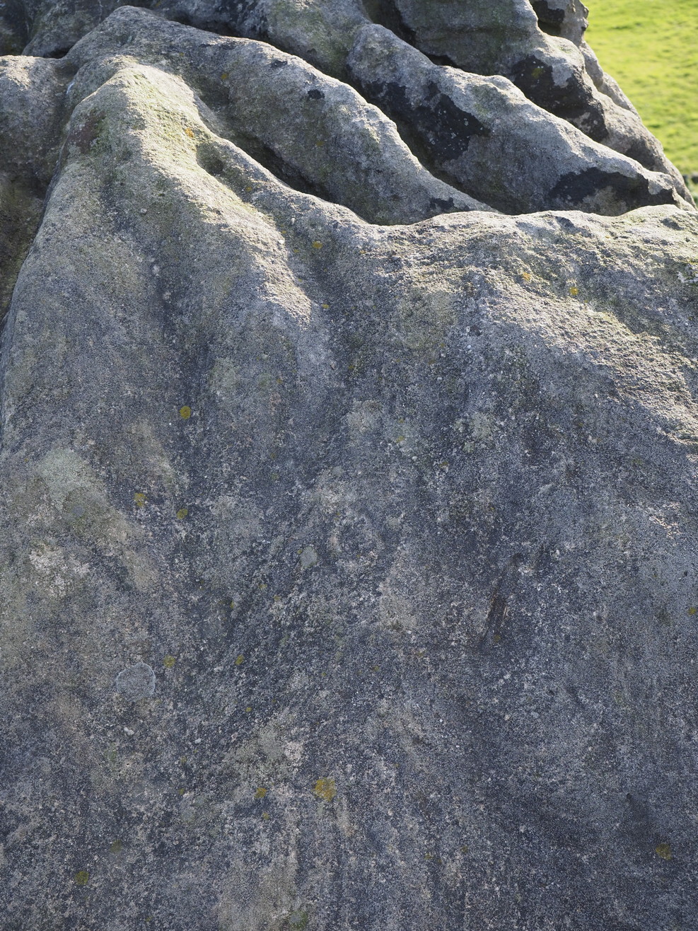
Carving in situ (photo courtesy Jim Ness)Carving looking N: courtesy Jim Ness
“lying almost immediately on the east side of Cist 1 is an angular rock…measuring 1m long and over 0.3m wide on the uppermost face, itself lying at an angle facing SW and away from the cist. The rock has fractured due to weathering in post deposition times, as indeed several other surface stones had, but on the widest part of the upper surface are at least seven concentric lines faintly pecked into the smooth flat surface of the stone. The lines are up to 10mm wide and appear to have been intended to form semi ovals on the edge of the rock. The outer ring forms an arc of c270mm on the long axis by c140mm on the short one (the former measurement being straight between the ends of the lines and the latter being a radius across the design). The terminals of the inner curved line are about 80mm apart. The lines are slightly irregular in distance from one another. Although it is far from certain, it does not appear that the rock has been part of a larger one with a more complete design on it, rather the pecking appears not to have been finished since the surface of the rock is similar in appearance overall while the abrasion of the carving varies.”
Fractured design (photo courtesy Jim Ness)
The carving remains in place with the cist, which was covered back over when the excavation had been finished.
Carvings such as this are uncommon in this neck o’ the woods; although less than a mile downstream from here, on the other side of the river, another petroglyph—known as the Drumelzier carving—accompanied another prehistoric tomb. Apart from this, there’s a great scarcity of carvings scattering the Lowlands—although it’s likely that there are others hiding away, waiting to be found on these hills…
References:
Royal Commission on the Ancient & Historical Monuments, Scotland, Peeblesshire – volume 1, Aberdeen University Press 1967.
Stevenson, R.B.K., “Cists near Tweedsmuir,” in Proceedings Society Antiquaries, Scotland, volume 74, 1940.
About mile south of Northchurch, on the far side of the A41 dual carriageway, somewhere past the old crossroads (or perhaps even at the crossing) an ancient tree lived—and truly lived in the minds of local people, for perhaps a thousand years or so. Mentioned in the Lay Subsidy Rolls in 1307, the Cross Oak gave its name to the old building that once stood in the trees and the hill itself, at the place now known as Oak Corner. Whether or not a “cross” of any form was set up by this old oak, records are silent on the matter. Its heathen ways however, were pretty renowned! (a plaque should be mounted here)
Folklore
The first reference I’ve found of this place is in William Black’s (1883) folklore survey where he told that “certain oak trees at Berkhampstead, in Hertfordshire, were long famous for the cure of ague”—ague being an intense fever or even malaria. But a few years later when the local historian Henry Nash (1890) wrote about this place, he told that there was only one tree that was renowned for such curative traditions, that being the Cross Oak. He gave us the longest account of the place, coming from the old tongues who knew of it when they were young—and it had it’s very own ritual which, if abided by, would cure a person of their malady. “The legend ran thus”, wrote Mr Nash:
“Any one suffering from this disease was to proceed, with the assistance of a friend, to the old oak tree, known as Cross Oak, then to bore a small hole in the said tree, gather up a lock of the patient’s hair and make it fast in the hole with a peg, the patient then to tear himself from the tree, leaving the lock behind, and the disease was to disappear.
“This process was found to be rather a trying one for a weak patient, and by some authority unknown the practice was considerably modified. It was found to be equally efficacious to remove a lock of hair by gentle means, and convey it to the tree and peg it in securely, and with the necessary amount of faith the result was generally satisfactory. This is no mere fiction, as the old tree with its innumerable peg-holes was able to testify. This celebrated tree, like many other celebrities, has vanished, and another occupies its place, but whether it possesses the same healing virtues as its predecessor is doubtful. It is however a curious coincidence, that the bane and the antidote have passed away together.”
The lore of this magickal tree even found its way into one of J.G. Frazer’s (1933) volumes of The Golden Bough, where he told how the “transference of the malady to the tree was simple but painful.”
Traditions such as this are found in many aboriginal cultures from different parts of the world, where the spirit of the tree (or stone, or well…) will take on the illness of the person for an offering from the afflicted person: basic sympathetic magick, as it’s known. Our Earth is alive!
References:
Black, William G., Folk Medicine, Folk-lore Society: London 1883.
Frazer, James G., The Scapegoat, MacMillan: London 1933.
Jones-Baker, Doris, The Folklore of Hertfordshire, B.T. Batsford: London 1977.
Nash, Henry, Reminiscences of Berkhamsted, W. Cooper & Nephews: Berkhamsted 1890.
Acknowledgements:Huge thanks for use of the Ordnance Survey map in this site profile, reproduced with the kind permission of the National Library of Scotland.
Travel along the B867 road from Bankfoot to Dunkeld (running roughly parallel with the A9) and you’ll reach the hamlet of Waterloo about one mile north of Bankfoot. As you approach the far end of the village, keep your eyes peeled for the small turning on your left and head up there for just over a mile. The road runs to a dead end at Meikle Obney farm, but shortly before reaching there you’ll pass this large standing stone on the right-side of the road, just along the fence-line. It’s almost impossible to miss!
Archaeology & History
This is one of “the large rude upright stones found in the parish” that William Marshall (1880) mentioned briefly, amidst his quick sojourn into the Druidic history of Perthshire. It’s an impressive standing stone on the southern edges of the Obney Hills that doesn’t seem to be in its original position. And it’s another one that was lucky to survive, as solid metal staples were hammered into it more than a hundred years ago when it was incorporated into the fencing, much like the massive Kor Stone 6½ miles south-west of here.
Site shown on 1867 mapWitch’s Stone at roadside
Shown on the first Ordnance Survey map of the area in 1867, its bulky 6½-foot-tall body stands all alone on this relatively flat plain, with open views to the east, south and west. It gave me the distinct impression that it was once part of a larger megalithic complex, but I can find no additional evidence to substantiate this. Call it a gut-feeling if you will. Intriguingly, the closest site to this are two standing stones just out of view literally ⅔-mile (1.07km) to the northeast, aligned perfectly to the Witch’s Stone! Most odd…
Folklore
The story behind this old stone is a creation myth that we find all over the country, but usually relating to prehistoric tombs more than monoliths. The great Fred Coles (1908) wrote:
“the common legend is told of a witch who, when flying through the air on some Satanic behest, let the Stone fall out of her apron.”
Marshall, William, Historic Scenes in Perthshire, William Oliphant: Edinburgh 1880.
Stewart, Elizabeth, Dunkeld – An Ancient City, Munro Press: Perth 1926.
Acknowledgements:Huge thanks for use of the Ordnance Survey map in this site profile, reproduced with the kind permission of the National Library of Scotland.
Holy Well (destroyed): OS Grid Reference – SP 4506 4055
Archaeology & History
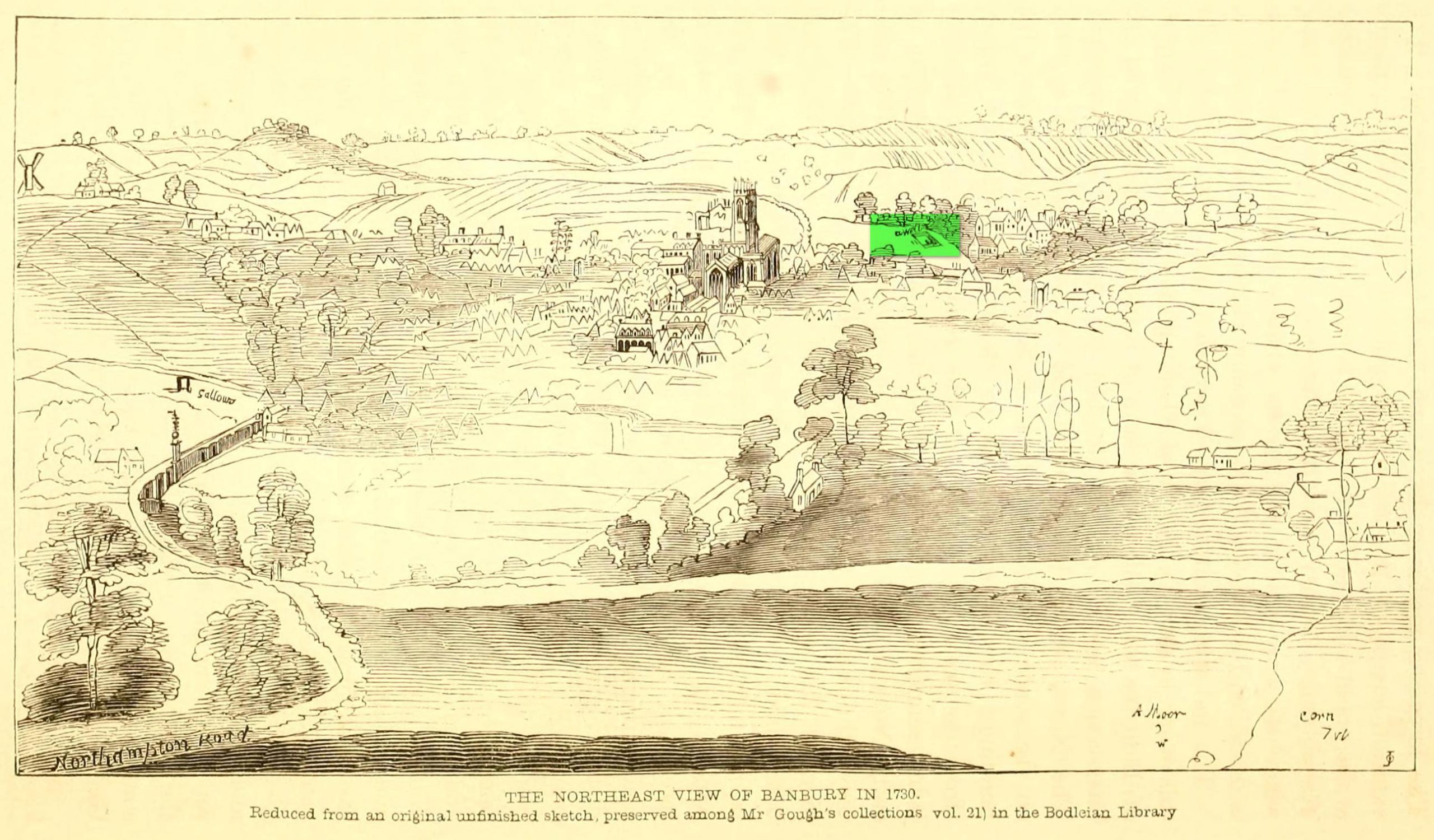
Well highlighted, in 1730
The holy well of Banbury seems to have been destroyed sometime in the second-half of the 19th century, when the industrialists built over the area. When the historian Alfred Beesley (1841) wrote about it, the waters were still running. He told it to be, “a chalybeate spring, well-known and still often visited, situated on the west side of the town, a little north of the footway leading to North Newington.”
The footpath is obviously long gone—as is the well. It’s iron-bearing (chalybeate) properties would have given the waters good fortifying properties, perhaps of some renown to local people yet, according to Mr Beesley, it was a slow-flowing spring. In his brief history of the site, he also gave us the results of a chemical examination of its healing waters, telling us:
“This is called St. Stephen’s Well in a plan of Sir John Cope’s property at Banbury made in 1764. It also appears prominently as “A Well ” in an unfinished view of Banbury made in 1730 (illustrated above)….
The water of this spring is perfectly clear and colourless, having a brisk and slightly chalybeate taste. The stone channel is coated with a light red deposit, and a scum of the same colour appears on the water in parts where stagnant. The spring discharges from half a gallon to one gallon in a minute. In 32 oz. of the water at 60° are,
Carbonic Acid gas, 5 cubic inches
Hydrochlorate Magnesia, 0.21 grains.
Chloride Sodium or common Salt, 0.54
Sulphate Lime, 1.5
Carbonate Lime, 3.8
Protoxide Iron, 0.024
Silica a trace
Total weight of solid contents – 6.074″
Folklore
St. Stephen is an odd character. His annual celebration or feast day in Britain is December 26. (in eastern countries it’s a day later) Rites connected to this character are decidedly heathen in nature. From the 10th century, in England, St Stephen’s Day has been inexorably intertwined with horses, bleeding them on his feast days, apparently for their own health. Water blessed by priests on this day would be kept for the year and used as a medicine for horses during that time. Also on this day, young lads would “hunt the wren” and, once caught, impale it on top of a long pole and take it from house to house. Despite this curious motif being a puzzle to folklore students, Mircea Eliade (1964) explained how this symbolism is extremely archaic and “the bird perched on a stick is a frequent symbol in shamanic circles.”
Eliade, Mircea, Shamanism – Archaic Techniques of Ecstasy, Princeton University Press 1964.
Harte, Jeremy, English Holy Wells – volume 2, Heart of Albion press: Wymeswold 2008.
Johnson, William P., The History of Banbury, G. Walford: Banbury 1860.
Acknowledgements:Huge thanks for use of the Ordnance Survey map in this site profile, reproduced with the kind permission of the National Library of Scotland.
The exact location of this site seems privy to a select few and has remained that way since its existence appeared in print in the 19th century. It was first mentioned by Arthur Mitchell (1874) following a holiday that he’d had in the area in the early 1870s. He’d visited a petroglyph at Laggan with a Mr David Ross and when he returned home received a letter from him that told how,
“he had heard from Mr M’Bain of Auchterblair of two huge granite boulders, situated on a shelving rock over an abyss on the Loch Avon side of Cairngorm, with hand-made cups on them about a foot wide and correspondingly deep.”
They were subsequently visited by Thomas Wise (1884) a few years later, who told how these huge granite boulders were,
“20 feet in height,” upon which “there are four basins, 1 foot, or 1 foot and a-half long, and 6 inches wide at the top, rounding off to 1 inch in the bottom.”
Initially Mr Mitchell (1874) was cautious in associating these carved basins with cup-marked stones—and indeed, we concur with this—but seemed to have changed his opinion when he wrote about them a few years later (Mitchell 1881). But it’s the folklore attached to this site that intrigued him – and myself…
Folklore
The traditions attached to this site will be recognised by all students of animism and folklore. Arthur Mitchell (1874) was informed how the carved bowls in the stone helped infertile women and how “sitting on (them) is said to be efficacious in cases of barrenness.” Their importance was highlighted in the fact that there had been “pilgrimages to them undertaken within the memory of people still living.”
This was affirmed by Thomas Wise (1884) who told that,
“They are supposed to be efficacious in barrenness, and people still living remember pilgrims coming to sit upon them for some time, that they might obtain what they wished. A visit to them was by no means an easy task, as the ascent was difficult, and to sit on them required a steady head, as they are on the brink of a rock overhanging a precipice. These basins are the “woman’s stone” mentioned by Tennant. They are supposed to be the resting place or throne of a certain fairy queen; but however efficacious they may have been, they have lost much of their celebrity; and as the shepherd, who acted as guide to the pilgrims, is dead, and has left no successor, they are now rarely visited.”
Does anyone know the whereabouts of this heathen magickal site? If you happen to find it, see if you can get a good photo or two and let us know on our Facebook group.
Maypole (destroyed): OS Grid Reference – SU 655 781
Archaeology & History
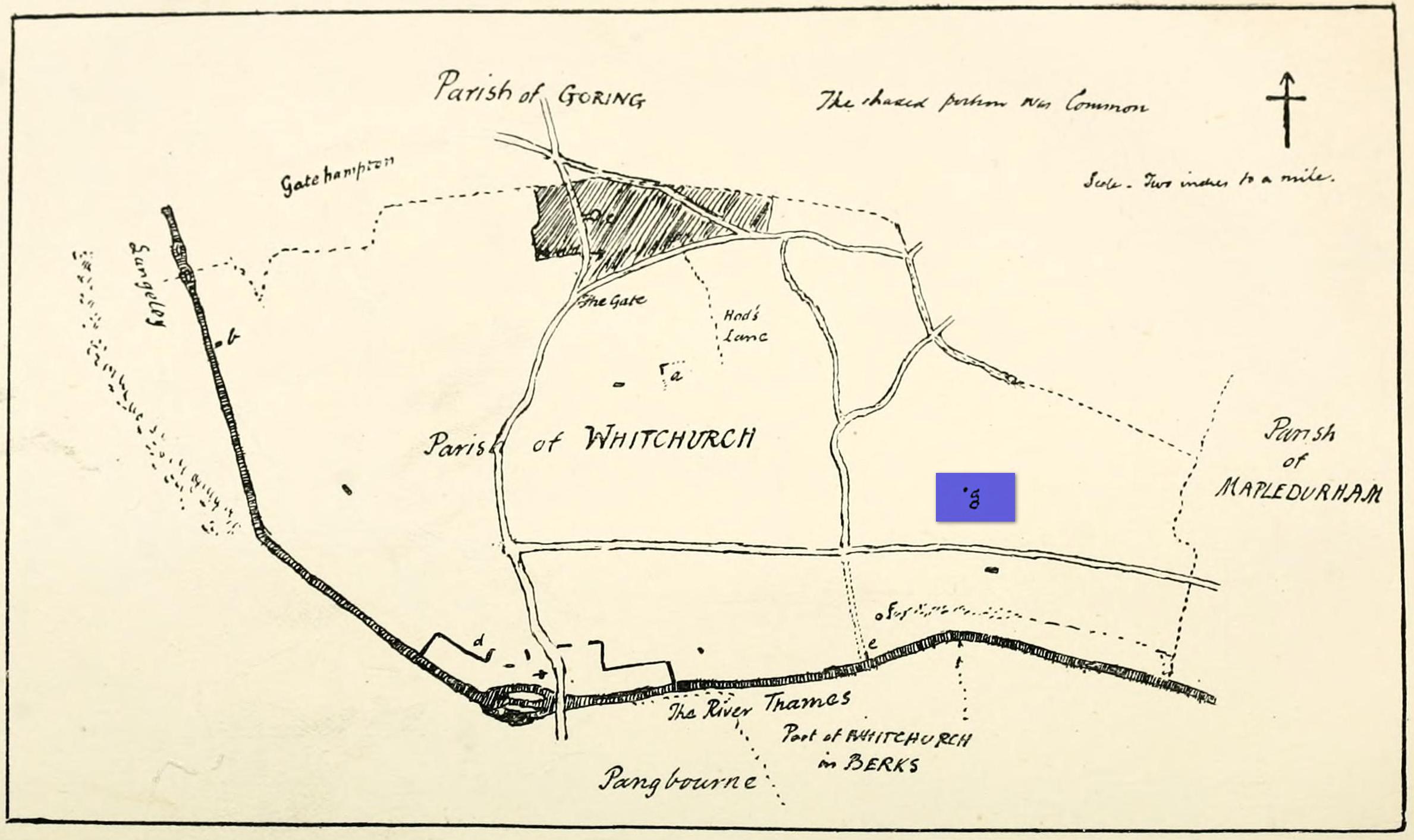
“g” marks the spot!
Very little is known about the history surrounding Whitchurch’s maypole that once stood more than a mile east of the village, somewhere in the woods immediately south of the present-day cannabis-growing Hempem Organics. (damn those hippies!) Mentioned in the Enclosure Acts of 1806 and 1813 as the “May Pole Ground”, the monument was mentioned in the Rev. John Slatter’s (1895) local history work and its approximate location was shown on a hand-drawn map he did of the area, in the grounds north of Hardwick House. He told us that it stood on “an elevated site” and conjectured that it might once have been a place of druidical worship!
“In the centre of the Hardwick property is a plot of ground called the Maypole Piece…. It is an open space, with a tree standing alone, where we may suppose the maypole formerly stood. There is a memorandum made by the last Mrs. Lybbe (nee Isabella Twysden) to this effect:
1713: A maypole set up on ye hill in ye straight way to Collinsend.”
In the event that you manage to discover anything else about the history of this maypole, let us know on our Facebook group.
References:
Gelling, Margaret, The Place-Names of Oxfordshire – volume 1, Cambridge University Press 1953.
Slattter, John, Notes on the History of the Parish of Whitchurch, Elliot Stock: London 1895.
This is an outstanding site visible for miles around in just about every direction – so getting here is easy! If you’re coming from Harrogate, south down the A658, turn right and go thru North Rigton. Ask a local. If you’re coming north up the A658 from the Leeds or Bradford area, do exactly the same! (either way, you’ll see the crags rising up from some distance away) As you walk to the main crags, instead of going to the huge central mass, you need to follow the line of walling down (south) to the extended cluster of much lower sloping rocks. Look around and you’ll find it!
Archaeology & History
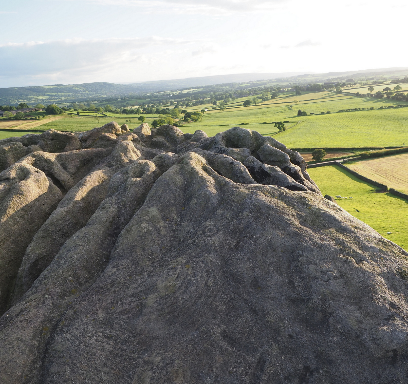
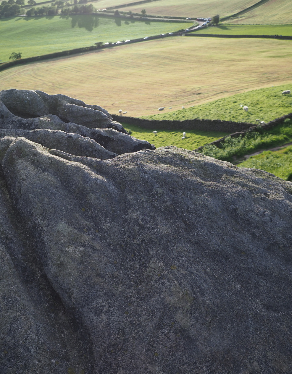
On the evening of May 27, 2024, I received a phone call from a Mr James Elkington of Otley. He was up Almscliffe Crags and the wind was howling away in the background, taking his words away half the time, breaking the sentences into piecemeal fragments. But through it all came a simple clarity: as the sun was setting and the low light cut across the rocky surface, a previously unrecorded cup-and-ring design emerged from the stone and was brought to the attention of he and his compatriot Mackenzie Erichs. All previous explorations for rock art here over the last 150 years had proved fruitless—until now!
Looking northwest
Central cup-&-ring
On the east-facing slope of the stone, just below the curvaceous wind-and-rain hewn shapes at the very top of the boulder, is a singular archetypal cup-and-ring. It’s faint, as the photos show, but it’s definitely there. What might be another cup-and-ring is visible slightly higher up the sloping face, but the site needs looking at again when lighting conditions are just right! (you can just about make it out in one of the photos) But, at long last, this giant legend-infested mass of Almscliffe has its prehistoric animistic fingerprint, bearing fruit and giving watch to the countless heathen activities going back centuries. Rombald’s wife Herself might have been the mythic artist of this very carving! (if you want to read about the many legends attached to the major Almscliffe rock outcrop, check out the main entry for Almscliffe Crags)
Sacred Well (destroyed): OS Grid Reference – SE 3953 1570
Archaeology & History
The precise whereabouts of this site isn’t known with absolute certainty, but, following research by the respected folklorist and pagan historian Steve Jones of Wakefield, the grid-reference cited here has a high degree of probability about it. I certainly agree with Steve about its location.
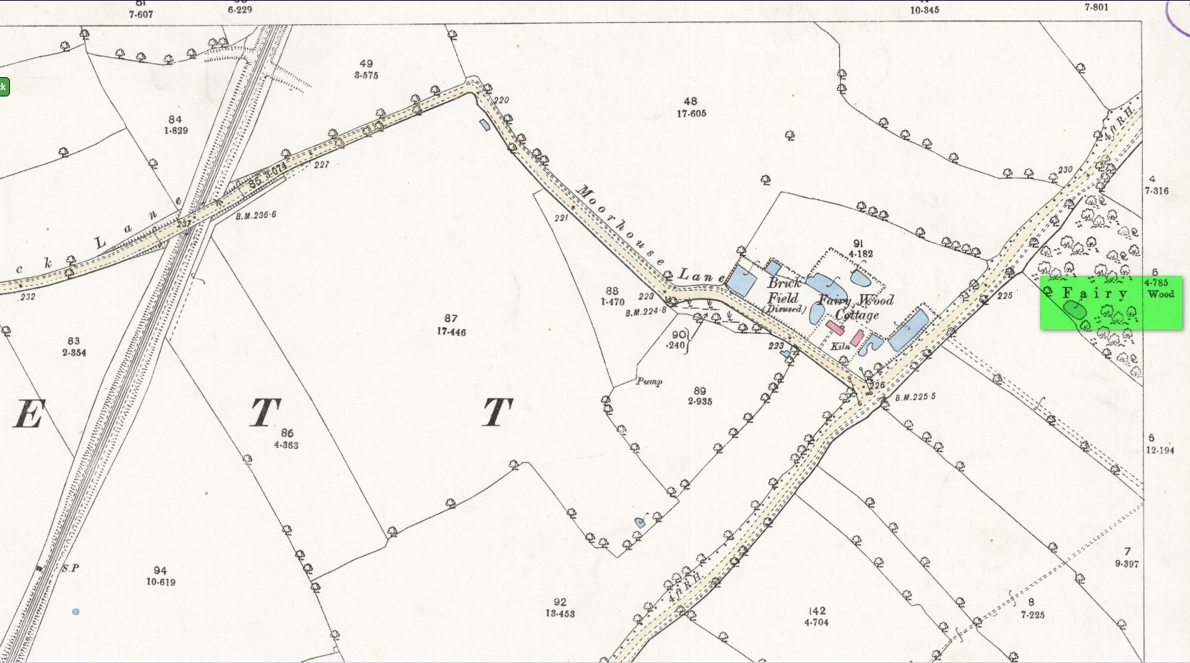
Pond in Fairy Wood, shown on the 1893 OS-map
Fairy Wood near Nostell, probable home of the Well
Known about in the 19th century, I was fortunate in coming across what seems to be the only reference to the place whilst perusing the scrapbook notes of local historian John Wilson (1903). Were it not for him we would have lost all knowledge of its existence and the local tale told of it, albeit watered into a dying belief in these supernatural creatures, would have faded completely before its final physical demise. Wilson was described as a “diligent a student of local history,” who possessed a great collection of rare booklets and pamphlets on Yorkshire history and was a “careful an observer and recorder of all pertaining to past times.” Of this Fairy Well, Wilson scribed the following poem:
At Nostell is a Fairy Well,
Hard by the margin of a wood
Wherein once dwelt, as old men tell,
The little folks of fickle mood ;
Till smoke and steam denied the dell
And made them quit both wood and well.
Blythe Henry Carr, mine ancient friend,
— So bravely keeping on his feet ;
May death long spare him,
still to wend His way along the village street,
Within the cobbler’s shop to spend
A pleasant hour — mine ancient friend.
The woodman at the Priory
In old Sir Rowland’s halcyon days
Was Thomas Watson, gay and free,
Who roused with song the woodland ways
A friend of Henry Carr’s was he,
—The woodman at the Priory.
This Watson many a tale could tell
Of fairies red and fairies green,
That in the wood and by the well
On summer evenings he had seen:
Of elves that thereabouts did dwell
This Watson many a tale could tell.
Whoever heard of such a thing!
He said that persons, known to him,
At eve would flasks of liquor bring,
And leave them, lying near the brim
Of this — the wondrous Fairy Spring —
Whoever heard of such a thing !
Was ever such a tale yet told ?
He said, that, when the morning came,
Each flask lay empty, and, behold !
Near each a drunken elf. O, shame !
The vice of those of mortal mould :
— Was ever such a tale yet told ?
Then question I mine ancient friend:
“Did no one seize the tipsy sprites? ”
“Not they ! for sudden is his end
On whom the fairy vengeance lights.”
With solemn eyes that fear portend
Thus answers me mine ancient friend.
Steve Jones already knew of the Fairy Wood, which was highlighted on the 1841 and 1854 6-inch-to-the-mile OS-map of the area—but no “Well” is shown in the woods. However, as Steve discovered, following a subsequent visit by the Ordnance Survey lads in 1891, they showed on their 25-inch-to-the-mile map of the woods a distinct small pond in the trees not far from the roadside. This, he thought, was probably the Fairy Well referred to by Wilson. It would seem so. Adjacent to the woods, the 1853 Tithe Award cite the existence of a field also dedicated to the fairy folk, known simply as Fairy Close.
References:
Smith, A.H., The Place-Names of the West Riding of Yorkshire – volume 1, Cambridge University Press 1961
Huge thanks to the research by Steve Jones of Wakefield, without whose work the location of the Fairy Well would have remained a mystery. Also, thanks as always for use of the early edition OS-maps, Reproduced with the kind permission of the National Library of Scotland.
Holy Well (lost): OS Grid Reference – NC 725 538 (approximation)
Archaeology & History
It would appear that there’s only one literary reference to this seemingly lost holy well, located halfway down megalithic Strathnaver, somewhere close to the legendary Loch ma Naire. James Horsburgh’s (1870) essay on the antiquities of this area mentioned it, almost in passing, in his description of the Dun Viden broch. He told that,
“Close to Dun Viden is Loch Manaar, where dozens of people come twice every year for the cure of diseases. They come before sunrise, bathe in the loch, walk round it, drink from a holy well (my emphasis), and throw some pieces of money into the loch. There is a legend about this loch, which I forget; but a woman was chased by a priest, and threw something in it, and called out that it was Loch Manaar—that is, the loch of my shame. “
The holy well is referred to in Historic Scotland’s Canmore entry, citing both the New Statistical Account and Name Books as referrals to the site, yet neither of them include this well in their surveys; it is only through Horbugh that we hear of this site—and we know not where it lived! In the event that it still exists, we’d expect it to be not more than 2-300 yards from the edge of Loch ma Naire; or perhaps it may be the source of the Loch ma Naire burn itself, nearly a mile to the east…. Seek and thee shalt find, as the old saying goes…
Holy Well (lost): OS Grid Reference – NH 6072 8954
Archaeology & History
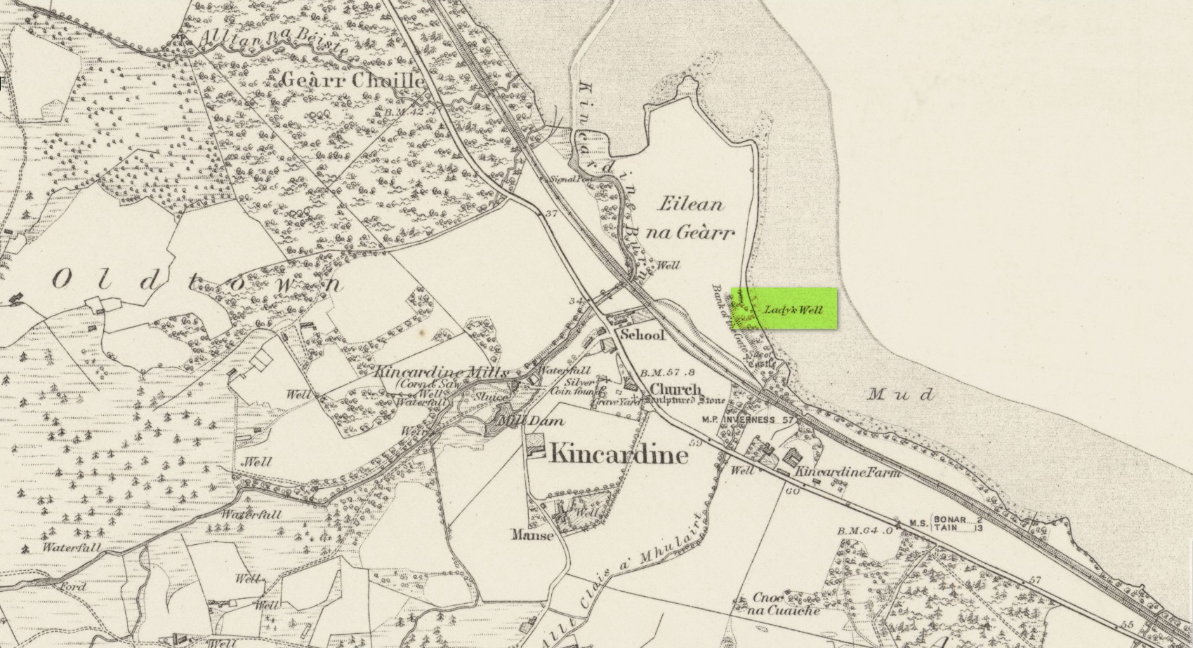
Site shown on 1879 map
First highlighted on the 1879 Ordnance Survey map, information on this site is sparse, save for those reliable Statistical Accounts and Name Books, which simply give us its location. The only context that our Old Statistical lads gave us was its relationship and proximity to a castle, “the most ancient residence” of the Clan Ross Highland Chiefs which could “be seen in a beautiful field between the church and the sea side.” At the end of this field is “a steep bank, hanging over the sea at high water called the ‘Bank of the Gate’, and at the bottom there is a spring of excellent water, called the Lady’s Well.”
The water’s dedication to Our Lady was obviously grafted onto it by those in the church above, glossing over, no doubt, earlier dedications by local people, whose practices seem to have been lost. The site was included in the regional Name Book of the Ordnance Survey doods who, it seems, merely copied the notes about the place from the old Statistical Account. In what seems to have been their last visit, no trace of the well was evident. They concluded it “was under water at time of visit.”
It would be good to hear from local folk if this sacred site can still be found at the tree-line just above the sea, or whether Nature has taken it away from Her animals.
Acknowledgements: Big thanks for use of the early edition OS-map in this site profile, Reproduced with the kind permission of the National Library of Scotland.