Healing Well (destroyed): OS Grid Reference – TQ 3496 9623
Also Known as:
King Ring Well
Tim Ringer’s Well
Archaeology & History
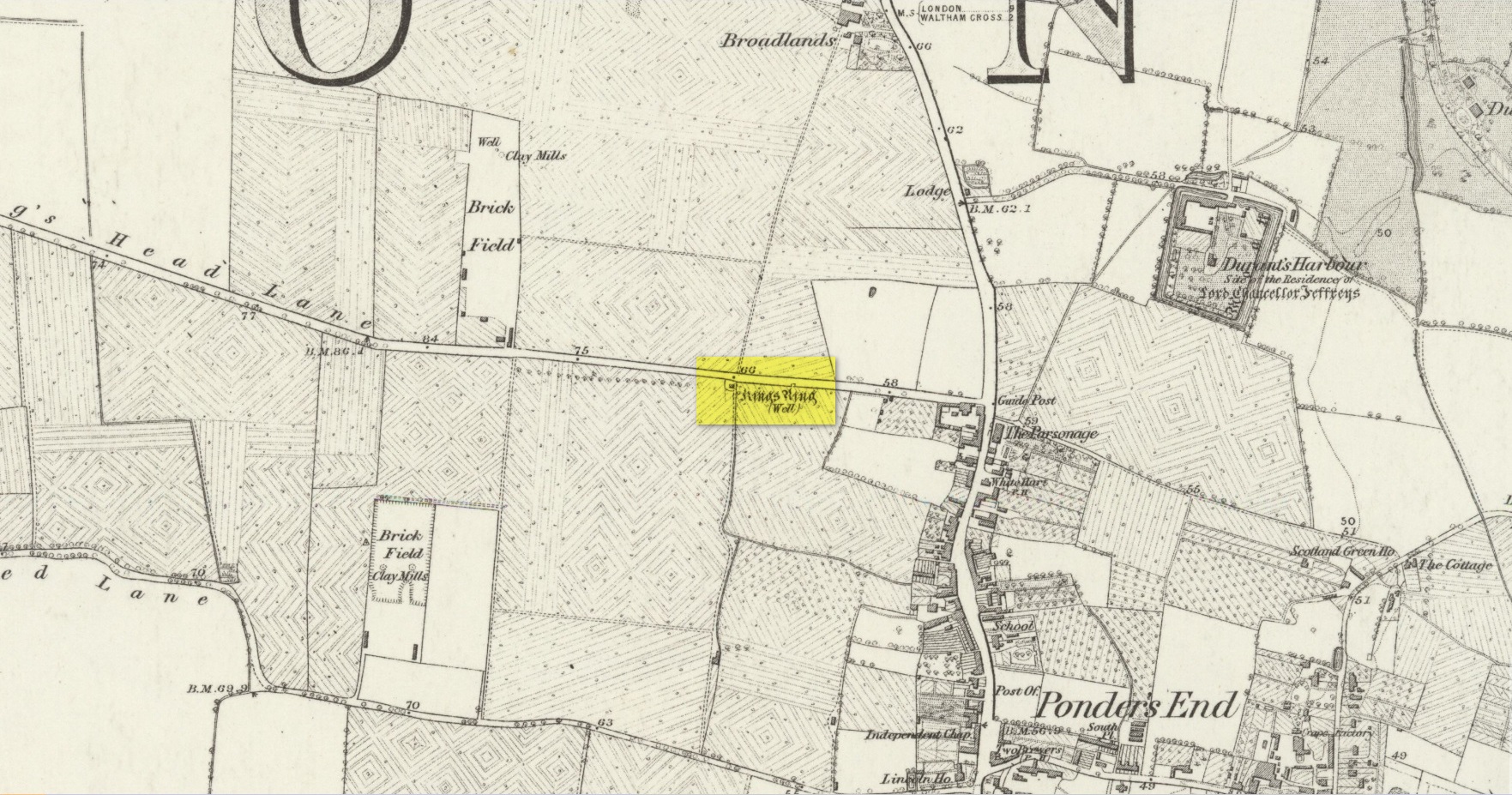
Site shown on 1879 map
Highlighted on the 1879 Ordnance Survey map, on the south-side of Southbury Road close to Ponders End, this curiously-named water source has a somewhat mundane history to it. It’s likely that an old stone conduit that was shown on John Ogilby’s 1698 road map of the area is the King’s Ring Well—although it hadn’t acquired that name at the time. It was described for the first time in Robinson’s (1823) classic work, located “on the south side of Gouldsdown-lane,”—which later became known as Nag’s Head Lane and today is Southbury Road. Anyhow, he continued telling us that here,
“there is a moat dividing two square fields. In the first there are remains of stables, barns, &c. and hollows, as of vaults, among the trees. There is a deep well, bricked, called “King Ring” or “Tim Ringer well,” (Timothy Ring was an opulent farmer who occupied the lands; and it is supposed from his arrogant manner obtained the nic-name of “King Ring.”) whose spring, it is said, never freezes nor dries up, and the water is esteemed very efficacious in disorders of the eyes.”
Robinson noted that the local drovers, “who from being so much exposed to the dust are subject to sore eyes, frequently turn up the lane to use the water, and there have been instances of children being cured of sore eyes by it after the measles.” He also alluded to a tradition that a religious house or convent once stood hereby, although he never obtained accurate information to prove his idea. If that was the case, the site may have been a holy well. The medicinal properties of the waters were repeated in Lewis’ Topographical Dictionary (1848); and again in Hodson & Ford’s (1873) subsequent survey of Enfield, emphasizing that it was “considered infallible as a remedy for inflammation of the eyes.” Sadly the well has long since been destroyed.
Acknowledgements:Huge thanks for use of the Ordnance Survey map in this site profile, reproduced with the kind permission of the National Library of Scotland.
Holy Well (destroyed): OS Grid reference – TQ 3337 8245
Archaeology & History
Holywell Lane on 1877 map
First described at the beginning of the 12th century as “fons qui dicitur Haliwelle“, these sacred waters were thereafter described in a variety of documents before eventually, in 1382, giving its name to the road on which it was found. When the topographer John Stow (1603) described the well—along with those of St. Clement’s and Clerken Well—it was once “sweet, wholesome, and clear” and “frequented by scholars and youths of the city in the summer evenings.” However, in his day it was already in decline, as he told that the “Holy well is much decayed and spoiled, with filthiness purposely laid there, for the heightening of the ground for garden plots.”
The history of the site was mentioned in John Noorthouck’s (1773) survey, where he told us:
“In the parish are two prebends, and part of a third, belonging to St Paul’s cathedral, in the city of London: The first dominated by Eald-Street, or Old Street, received that appellation from the Saxons being part of the Roman military way: the second, which had been a separate village for many years, by the name of Hochestone, vulgarly Hoxton, likewise itself to be of a Saxon origin: the third called Haliwell, had its name from a vicinal fountain, which, for the salubrity of its water, had the epithet Holy conferred on it.
In King John’s Court, Holywell-lane, are to be found the ruins of the priory of St. John Baptist, of Benedictine nuns, founded by Robert the son of Gelranni, prependary of Haliwell, and confirmed by charter of Richard I in the year1189. It was rebuilt in the reign of Henry VII by Sir Thomas Lovell, knight of the garter; who was there buried: and the following ditty was in consequence painted in most of the windows.
“All the nuns of Holywell,
“Pray for the soul of Thomas Lovell.”
The complete demise of the well occurred in the early part of the 19th century and efforts to locate its original position have proved troublesome. Indeed, the modern Holywell Lane would seem to be little more than an approximation of its whereabouts. It was an issue explored at some length in the great A.S. Foord’s (1910) magnum opus, who wrote:
“In recent times efforts have been made to locate the well, and some of the results communicated to Notes and Queries. A Mr. R. Clark drew attention, through the medium of that publication, to an article in The Builder of September 19, 1896, which states that ”the ancient holy well should be looked for in the area between Bateman’s Row and New Inn Yard and behind the Board School in Curtain Road, that is to say, west of New Inn Street.” This is all very circumstantial, but the writer bases his statement on the survey by Peter Chassereau, taken in 1745, in which the supposed position of the well is marked by a cross and the words “Ye well from which the liberty derives its name.” It should be borne in mind however that, as pointed out by Colonel W. F. Prideaux, Chassereau did not make his survey till more than two hundred years had elapsed from the date of the dissolution of the Nunnery (1539); the position of the well could therefore have been only a matter of tradition. Another contributor to Notes and Queries (8th Series, May 22, 1897), quotes an article in the Journal of the Royal Institute of British Architects (vol. iv., 3rd series, p. 237), by Mr. E. W. Hudson, who says that the well of the priory was situate on the south side of what is known as Bateman’s Row, but was formerly (before 1799) called Cash’s Alley, near Curtain Road. This agrees substantially with Mr. Clark’s statement. Mr. Lovegrove, writing in 1904, says: “The well itself is to be found in a marble-mason’s yard in Bateman’s Row, but is covered over.” The same writer notes that of the Nunnery buildings only a piece of stone wall about 50 feet long, in a timber yard at 186, High Street, Shoreditch, is now left.”
References:
Foord, Alfred Stanley, Springs, Streams and Spas of London: History and Association, T. Fisher Unwin: London 1910.
Gover, J.E.B., Mawer, Allen & Stenton, F.M., The Place-Names of Middlesex, Cambridge University Press 1942.
Lovegrove, G.H., “Holywell Priory, Shoreditch,” in Home Counties, volume 6, 1904.
Mills, A.D., A Dictionary of London Place-Names, Oxford University Press 2001.
Noorthouck, John, A New History of London, Including Westminster and Southwark, R. Baldwin: London 1773.
Stow, John, A Survey of London, John Windet: London 1603.
Sunderland, Septimus, Old London Spas, Baths and Wells, John Bale: London 1915.
Wood, Alexander, Ecclesiastical Antiquities of London, Burns & Oates: London 1874.
Healing Well (destroyed): OS Grid reference – TQ 330 827
Also Known as:
Balsamick Well
Archaeology & History
In that typically rambling style beloved of early writers on medicinal springs, Timothy Byfield (1687) narrated the tale of uncovering this well in an almost alchemical discourse. It was located when digging out the cellar of a house near Charles Square in the 1680s. Upon investigation, the waters were found to possess a good quantity of sulphur and a small amount of iron, leading Byfield to proclaim it could cure a whole army of medical disorders, from cleaning out blockages in the alimentary canal, to treating kidney stones, scurvy, ulcers, headaches, migraines and more. If used correctly and in the right amount,
” There is,” he says, “no unwholesome glebe (concretion) or any dangerous mineral or metal (in them) that casts one unhappy ray into this healing fountain.” On the contrary, they set up ‘* such a pretty bustle or ferment in nature that makes gay a well-temper’d Healthy Body.”
In the early days when Spa Wells were in vogue, the Balsamic Well became a competitor to the nearby St Agnes le Clear Well, which is probably the reason why one doctor dissuaded the toffs of the time to avoid it!
The waters possessed a slight vinegar-esque flavour—hence the name. In John MacPherson’s (1871) work, he described it as a “chalybeate well” and despite it having that typical “bituminous scum on it, strange to say,” it yielded “a pleasant aromatic flavour.” The site has long since been covered over.
References:
Byfield, Timothy, A Short and Plain Account of the late-found Balsamick Wells at Hoxdon, London 1687.
Foord, Alfred Stanley, Springs, Streams and Spas of London: History and Association, T. Fisher Unwin: London 1910.
Hembry, Phyllis, The English Spa 1560-1815, Athlone Press: London 1990.
MacPherson, John, Our Baths and Wells, MacMillan: London 1871.
Sunderland, Septimus, Old London Spas, Baths and Wells, John Bale: London 1915.
The site of the well, which was in the historic county of Middlesex, appears to have been on the west side of the present Moorefields Road just north of the junction with St Loy’s Road. The OS reference is an approximation. The restored circular well house to the south of the High Cross at the High Road – Philip Lane junction now popularly known as ‘The Old Well’ or ‘The Old Pump’ by Tottanham Green has been referred to as being ‘St Eloy’s Well’ but this is not the historic well described in this profile.
Archaeology & History
Likely position of the well on the 1873 6″ OS Map
The well was still in existence in 1876, but by the time of the revision of the OS map around 1894, it had been destroyed following building of the Great Eastern Railway’s Enfield branch line and the construction of terraced housing along the new St Loy’s Road.
So where was the well? The 1873 6″ OS map shows a field on parts of which the railway line and St Loy’s Road are now built, and a small area of water is shown in this field which is the likely position of St Loy’s Well on the eve of its destruction, when it was described as a dirty pool of water full of mud and rubbish. If this was the position of the well then it has now been completely built over…
It was described by Robinson in his 1841 History of Tottenham as being:
‘..in a field….on the western side of the High Road…surrounded by willows…it is bricked up on all sides, square and about 4 feet deep..’ ‘ In Bedwell’s time [it was]…always full of water, but never running over; the water of which is said to exceed all other near it.’.. ‘the properties of the water are similar to the water of the Cheltenham springs’.
Thomas Clay ‘s 1619 map of Tottenham, illustrated in Robinson’s book shows a field north west of Tottenham High Cross called ‘Southfeide at St Loys’. The Tottenham historian Wilhelm Bedwell described the well in 1631 as:
‘“nothing else but a deep pit in the highway, on the west side thereof;”….”it was within memory cleaned out, and at the bottom was found a fair great stone, which had certain letters or characters on it; but being broken or defaced by the negligence of the workmen, and nobody near that regarded such things, it was not known what they were or meant.’
This fair great stone with its ‘certain letters or characters that no one knew what they were or meant’ is intriguing especially in view of the well’s proximity to the Roman Ermine Street (Now the High Street). Were those mysterious characters spelling out an undecipherable Latin inscription on a Roman stone? We shall never know, but it hints at a pre-Christian origin or veneration of the well. Another hint is that before the Reformation there was nearby a chapel of St Eloy known as the Offertory*, which may have been originally built to ‘Christianise’ a pre-existing heathen sacred spring. The Roman origins of the well are also hinted at (probably erroneously) by W.L. Bowles in 1830, writing of a ‘Druidical Tour’ that one Sir Thomas Phillipps undertook on the continent, first quoting Phillipps before adding his own conclusion:
‘“Near Arras in France, are found the mount of St. Eloi and the very name of a place, Tote. I have no doubt Druidical remains will be found there, if this be not the very country of Carnutes.”
Now let me observe, that Tote is Taute —Tot—Thoth, latinized into Tewtates by Lucan, &c. the chief deity of the Celts. St. Eloi is neither more nor less than the Celtic word Sul, turned into the Greek the Sun; and Elios, turned into the Catholic St. Eloi, as at Tottenham, Middlesex, anciently Tote-ham, the ham of Taute or Tent, where is also the sacred well of St. Eloi, or ‘Helios’, the Sun !’
Saint Eloi / Eloy /Loy / Eligius, is the patron saint of those who work in the alchemists’ metal of the sun – goldsmiths! He is also the patron saint of blacksmiths, farriers, and all who earned their livings from horses, and lived from around 588 to 660 to become Bishop of Noyon and the evangelising apostle for much of modern day Belgium. His feast day is 1st December, and he had a widespread cult in mediaeval Europe, including England. In addition to being a healing well for humans, one writer hints that the well’s waters may have been employed for healing horses…they certainly would have drunk from it with its proximity to what is now the High Street.
Around 1770, an artist called Townsend (the sources are unsure as whether it was a Mrs or Mr) produced a romanticised drawing of the well, which was exhibited at the Royal Academy in 1770-1. It depicts a hermit beside the well (the Hermitage of St Anne stood to the south of High Cross prior to the Reformation) receiving an offering from a lady. It was engraved and sold as a print, and may be the only image of the well before its demise.
Folklore
In 1819 – 20, John Abraham Heraud wrote a poem about St Loy’s Well, set in the time of St. Edward the Martyr, (the late 970s), entitled ‘ Stanzas in the Legend of St Loy‘ of which the most relevant verses are;
‘TOTEHAM! the Legend of thine olden day, To the last note hath on thine echoes died; But the Bard’s soul still lingers o’er the lay, To muse upon thy transitory pride The pride of times that hath been — blank and void— When all was Nature, big with many a song Of Chivalry and Fame, with Love allied— But Time both changed the scene — now houses throng Where once was solitude — and people crowd along.
Where now thy WOOD, that spread its misty shade O’er twice two hundred acres? — past away! And vain its PROVERB, as the things that fade, Earth, sun, moon, stars, that change as they decay! The lonely CELL, the tenor of the lay, Its grove, which hermit tendance loved to rear; And, St. LOY, mouldering to Time’s gradual sway, Thy rites, thy OFFERTORY disappear;— Forgot thy SPRING OF HEALTH no votary worships there!
Forgot, neglected — still my harp shall dwell On thee, thou blest BETHESDA of ST. LOY! As Fancy muses o’er the vital WELL On years of storied yore, with grief and joy, Exults they were — weeps Truth should e’er destroy! Thrice I invoke the Spirit of the Stream With charm she may not question, or deny, And, like a Naiad, o’er the watery gleam She rises to my voice, and answers thus the theme:— ‘
Heraud wrote a further poem mentioning the well, his ‘Tottenham‘ of 1820, the relevant verse being:
‘St. Loy! here is this fountain—emblem pure Of chaste unostentatious charity— Never in vain intreated, ever sure ; Yet o’er the marge thy waters fair and free Ascend not, overflowing vauntingly, But in thy bounty humble as unfailing, In grief, disease, and sickness, visit thee. But part in joy, changed by thy holy healing To manhood, strength, and life, thy far renown revealing. There is thy offertory, and thy shrine, Simple, inartificial ; nor of fame, Nor any honour, save that it is thine, And all its glory centres in thy name !’
*Footnote – Brian Spencer’s book on mediaeval pigrim badges recovered by archaeologists in London refers (p222) to a distinct ‘London pattern’ of St Eloi badge – is this a hint that the Offertory was a local shrine to St Eloi where such badges were sold to pilgrims? Further research is needed to try to verify this speculation.
The Cross is on the east side of the A10 Tottenham High Road, on the traffic island at the Monument Way Junction.
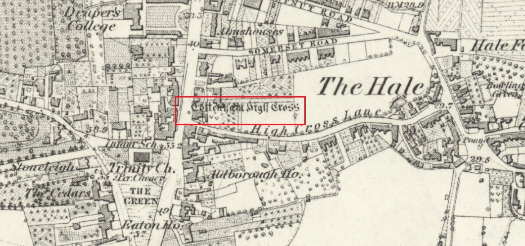
Archaeology & History
Cross shown on 1873 map
One of the earliest records of what was called the “hie crosse” is contained in a court-roll of 1456. It was at that time a wooden wayside cross, but there are hints that its origins may go back to Roman times. The Cross is next to what was the southern end of Ermine Street, built by the Romans where there was no pre-existing roadway and described as the most important thoroughfare in Britain: built to give direct communication to the main centres of the military occupation at Lincoln and York. Writing of Roman land survey marks, the now discredited early 20th century Middlesex historian Sir Montagu Sharpe (1932) thought Tottenham Cross possibly marked an earlier (i.e. Roman) stone, although no archaeological evidence has been found to support this. As it was next to Ermine Street it could equally have been a milestone or ceremonial pillar. After the Romans left it may have become a local heathen shrine which, with the coming of Christianity, was ultimately replaced by a wooden cross—but this is speculation, and we will probably never know why and when the original cross was placed where it was.
Originally in the historic County of Middlesex, the settlement of Tottenham surrounding the Cross was known from mediaeval times to the 19th century as ‘Tottenham High Cross’. Local historian William Robinson writing prior to 1840 thus describes the Cross:
“About the year 1580, a column of wood was standing, with a square sheet of lead on the top to throw off the water, supported by four spurs: these, being decayed and rotten, were taken down, about the year 1600, by Dean Wood, Dean of Armagh, who at that time resided in a house on the east side of it, and who erected on its site an octangular brick column, pointed at the top and crowned with a weathercock, and the initials of the four cardinal points, and under the neckings, small crosses, which were called tau-crosses, according to the true cross or Greek letter T.
“Tottenham High Cross, as it appeared in 1788, was an octangular brick pillar, divided into four stories, viz.: a double plinth, first portion of the pillar; second portion, of the same; and a pinnacle; each plinth and story rendered distinct one from the other by certain appropriate mouldings ; and the whole design appeared without any kind of ornament, pointed at the top and crowned with a weathercock. The Cross having fallen into decay, several of the inhabitants of the parish entered into a subscription, in the year 1809, for the purpose of putting it into a proper state of repair, and about the sum of £300. was raised. It was accordingly repaired, and covered with Parker’s cement. The octangular plan, and the proportions of the Cross in its four stories, have not been departed from ; but in other respects it is a new work ; some of the decorations seem to be formed from the exterior and interior of the chapel of Henry VIII; the double plinths or pedestals are as plain as before, but the intermediate mouldings are new; the first portion of the pillar consists of angular pilasters at each cant done with a pointed head; compartment of five turns, connecting itself with another compartment; above it diamonded, with a shield containing an imitation of the black letter. As there are eight faces to the upright, of course there are as many shields, each bearing a letter of the same cutting, beginning at the west face, TOTENHAM: in consequence of there being but eight shields, one of the T’s in the spelling has been necessarily dispensed with. The mouldings between this story and the second are worked into an entablature, with modern fancy heads and small pieces of ornaments alternately set at each angle.
“Second story—small buttresses at the angles of the octagon, with breaks and pinnacles, but no bases. The face of each cant has a compartment embellished with an ogee head, backed with narrow pointed compartments. The mouldings between this story and the pinnacle, making out a fourth story, give, at each angle, crockets, and its termination is with a double finial, but not set out in geometrical rule to the crockets below : there is at the top a vane, with N. E. W. S. The base is surrounded with a neat iron railing on Portland stone curb. The date at which these alterations were made is not placed in any conspicuous part of the structure.”
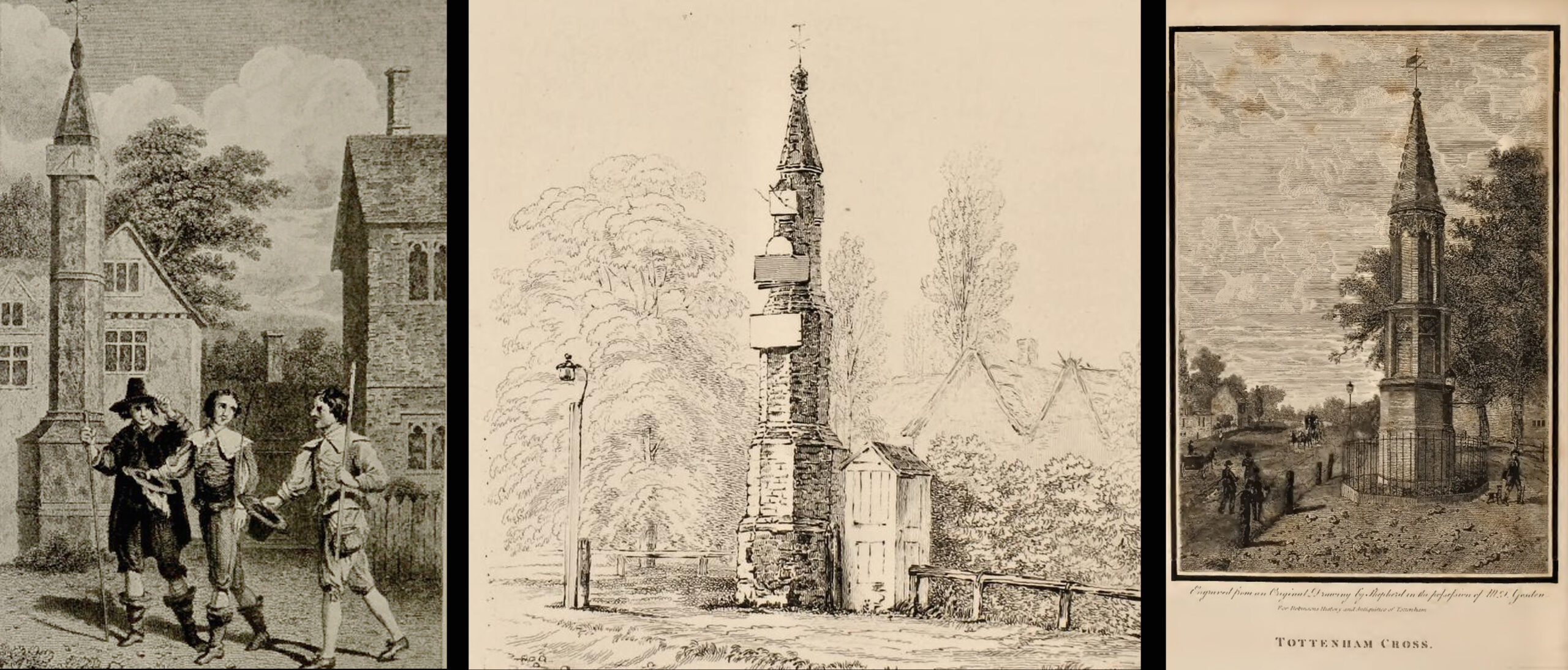
(left) engraving based on Samuel Wale’s 1759 illustration to Compleat Angler; (centre & right) 19th C views pre- and post-renovation
The craftsman who carried out the modernisation was a Mr. Bernasconia, working to the designs of a Mr. Shaw. Not everyone was pleased by the transformation. A regular contributor identified only as ‘An Architect’ made these caustic comments in the November 1809 edition of the Gentleman’s Magazine:
“Tottenham High Cross has this summer been covered over with Compo: it previously bore a simple appearance, but is now rendered of a very rich and elaborate cast, doing away in the first instance the Architectural history of the erection; and allowing it possible that there might once have been on the spot an Eleanora Cross, holding in contempt, by a want of due imitation, the characteristic style of decoration prevailed at at the time of the Queen’s demise. But according to the system of our Professional innovators, to destroy a sacred relick of antiquity, and to restore it as it is called, upon a model quite in a different style and nature, is one and the same thing. “Any thing is Gothick.”
“….Surveyed November 1809. Entirely covered with the proclaimed everlasting stuff, Compo; a stuff now the rage for trowelling over our new buildings, either on the whole surface, or in partial daubings and patchings; it is used in common with stone work, for instance, on an arcade, half one material, half the other; “ making good,” as it is called (abominable expedient) the mutilated parts of Antient Structures, there sticking on until it reverts (after exposure to the air for three or four years, more or less) to its first quality, dirt and rubbish, and then is seen no more….
“Provided this Compo effort had been advanced on any other occasion, and on any other piece of ground, where no piece of Antiquity was to become the spoil, such as an object to mark the centrical point of three or four counties, a general standard of miles or any other common document for the information or amusement of travellers, all would have been well, and some praise might have been bestowed, for its tolerable adherence to the above style, if not for the material wherewith it is made up. But as nothing of this sort will come in aid of the innovators, and only the barefaced presumption, “ alter or destroy, what was,” is to be encountered, let the detail of parts, put this matter to issue….”
Folklore
A modern view (Wikipedia Creative Commons)
The Cross stood in front of the Swan Inn, a place frequented by fishing writer Izaak Walton in the 1640s when he would go to fish in the nearby River Lea. In 1653 he published The Compleat Angler describing his fishing activities in the classical form of a philosophical dialogue between him as ‘Piscator’ and ‘Venator’ (hunter) and other passing characters, starting and ending his adventures at the High Cross. The 1759 edition of Compleat Angler contains the earliest illustrations of the Cross, with some slight artistic licence, by Samuel Wale.
Afterword
As the Cross now stands in the maelstrom of North London’s traffic, it is worth recalling American traveller Nathaniel Carter’s 1825 observation when travelling north from London:
“Passing Tottenham Cross, we entered a rich agricultural country, possessing the usual charms of English landscape.”
References:
An Architect (pseud.) – Architectural Innovation No. CXXXIX – The Gentleman’s Magazine, November 1809
Anonymous – Tottenham High Cross, The Gentleman’s Magazine, April 1820
Blair, John, The Church in Anglo Saxon Society, Oxford University Press 2005
Carter, Nathaniel Hazeltine, Letters From Europe..in 1825 ’26 & ’27, G & C & H Carvill, New York, 1829
Margary, Ivan D., Roman Roads in Britain, 3rd Ed., John Baker: London 1973.
Robinson, William, The History & Antiquities of the Parish of Tottenham, 2nd Ed., Nicholls & Son, W. Pickering, W.B. Hunnings: London 1840.
Sharpe, Montagu, Middlesex in British, Roman & Saxon Times, 2nd Ed., Methuen: London 1932.
Walton, Izaak, The Compleat Angler, Facsimile of the 1st Ed., containing illustrations from the 2nd US edition by John Major, No imprimatur, 1907.
Holy Well (destroyed): OS Grid Reference – TQ 332 911
Also Known as:
My Lady’s Hole
Archaeology & History
Long since gone after drainage operations on Tottenham Cemetery made the waters dry-up, this was one of several holy wells in the Tottenham area. Its history has been described in various old tomes, but the most definitive is found in William Robinson’s (1840) classic on the parish of Tottenham, when the well was still visible. He told us:
“There is a spring which issues from the side of a small hillock on the south side of the Moselle, nearly opposite the Vicarage, leading thence to the Church, called Bishop’s Well. This spring was formerly considered famous for many strange and wonderful cures performed on the diseased by the use of this water. It has been for some years neglected, but of late the owner of the field in which this well is, had it cleansed, and planted some trees round it, and put up posts and rails to prevent the cattle treading down the sides of it. It is said that the water of this well never freezes. In former times this well was in great repute from the purity of its water. The ladies in the vicinity of it were accustomed to send their servants in the morning and evening for water for their tea, from which circumstance it was for many years known by the name of “My Lady’s Hole.” The water of this well is not only esteemed for its medicinal qualities, but particularly for curing disorders of the eye.
“There were formerly many other springs about the village, especially one which issued out of the hill on which the Church stands; and another in Spottons Wood otherwise Spottons Grove, on the north side of Lordship Lane, which in the fifteenth century was of considerable notoriety; but none of which have in former times been so much frequented and held in such repute as Bishop’s Well.”
(Please note: the grid-reference for this site is an approximation)
References:
Foord, Alfred Stanley, Springs, Streams and Spas of London: History and Association, T. Fisher Unwin: London 1910.
Hope, Robert Charles, Legendary Lore of the Holy Wells of England, Elliott Stock: London 1893.
Holy Well (covered): OS Grid Reference – TQ 3157 8111
Archaeology & History
St Brides Well on 1896 map
Close to the centre of that corporate money-laundering place of homo-profanus that is the City of London, was once a site that represents the antithesis of what it has become. Tacked onto the southeastern side of St. Bride’s church along the appropriately-named Bride Lane, the historian Michael Harrison (1971) thought the Holy Well here had Roman origins. It “was almost certainly,” he thought,
“in Roman times, the horrea Braduales, named after the man who probably ordered their construction: Marcus Appius Bradua, Legate of Britain under Hadrian, and the British Governer in whose term of office the total walling of London was, in all likelihood, begun.”
This ‘Roman marketplace of Bradua’ that Harrison describes isn’t the general idea of the place though. Prior to the church being built, in the times of King John and Henry III, the sovereigns of England were lodged at the Bridewell Palace, as it was known. Mentioned in John Stow’s (1720) Survey of London, he told:
“This house of St. Bride’s of later time, being left, and not used by the Kings, fell to ruin… and only a fayre well remained here.”
The palace was eventually usurped by the building of St. Bride’s church. The most detailed account we have of St. Bride’s Well is Alfred Foord’s (1910) magnum opus on London’s water supplies. He told:
“The well was near the church dedicated to St. Bridget (of which Bride is a corruption; a Scottish or Irish saint who flourished in the 6th century), and was one of the holy wells or springs so numerous in London, the waters of which were supposed to possess peculiar virtues if taken at particular times. Whether the Well of St. Bride was so called after the church, or whether, being already there, it gave its name to it, is uncertain, more especially as the date of the erection of the first church of St. Bride is not known and no mention of it has been discovered prior to the year 1222. The position of the ancient well is said to have been identical with that of the pump in a niche in the eastern wall of the churchyard overhanging Bride Lane. William Hone, in his Every-Day Book for 1831, thus relates how the well became exhausted: ‘The last public use of the water of St. Bride’s well drained it so much that the inhabitants of the parish could not get their usual supply. This exhaustion was caused by a sudden demand on the occasion of King George IV being crowned at Westminster in July 1821. Mr Walker, of the hotel No.10 Bridge Street, Blackfriars, engaged a number of men in filling thousands of bottles with the sanctified fluid from the cast-iron pump over St. Bride’s Well, in Bride Lane.” Beyond this there is little else to tell about the well itself, but the spot is hallowed by the poet Milton, who, as his nephew, Edward Philips records, lodged in the churchyard on his return from Italy, about August 1640, “at the house of one Russel a taylor.”
In Mr Sunderland’s (1915) survey, he reported that “the spring had a sweet flavour.”
Sadly the waters here have long since been covered over. A pity… We know how allergic the city-minds of officials in London are to Nature (especially fresh water springs), but it would be good if they could restore this sacred water site and bring it back to life.
Folklore
Bride or Brigit has her origins in early British myth and legend, primarily from Scotland and Ireland. Her saint’s day is February 1, or the heathen Imbolc (also known as Candlemas). Although in christian lore St. Bride was born around 450 AD in Ireland and her father a Prince of Ulster, legend tells that her step-father (more probably a teacher) was a druid and her ‘saintly’ abilities as they were later described are simply attributes from this shamanic pantheon. Legends—christian and otherwise—describe Her as the friend of animals; possessor of a magickal cloak; a magickian and a healer; and whose ‘spirit’ or genius loci became attached to ‘sacred sites’ in the natural world, not the christian renunciation of it. St Bride was one of the primal faces of the great prima Materknown as the Cailleach: the Gaelic deity of Earth’s natural cycles, whose changing seasons would also alter her names, faces and clothes, as Her body moved annually through the rhythms of the year. Bride was (and is) ostensibly an ecological deity, with humans intrinsically a part of such a model, not a part from it, in contrast to the flawed judaeo-christian theology.
References:
Foord, Alfred Stanley, Springs, Streams and Spas of London: History and Association, T. Fisher Unwin: London 1910.
Gregory, Lady, A Book of Saints and Wonders, Colin Smythe: Gerrards Cross 1971.
Harrison, Michael, The London that was Rome, Allen & Unwin: London 1971.
McNeill, F. Marian, The Silver Bough – volume 2, William MacLellan: Glasgow 1959.
Cross (destroyed): OS Grid Reference – TQ 3077 8093
Also Known as
Stone Cross of the Strand
Archaeology & History
First mentioned in Latin manuscripts from 1274 CE, the best description of this long lost monument, curiously, appears to be in Gover’s Place Names tome. In a slightly edited format he told us the following:
“There was a stone cross “without the bar of the New Temple” traditionally supposed to have been erected by William Rufus “in devotion to the Holy Cross and for the health of the souls of himself and his mother, Queen Maud… It was in the Strand, possibly on the site of the present church of St. Mary. It is referred to as crucem lap’ in 1274; la Crois de Piere in 1293; …Stonecrouch in 1337; crucem fractum in 1342…”
In subsequent notes Gover et al (1942) tell of a man they found in historical records to be Thomas le Barber, “described alternatively as being Thomas le Barber atte Stonecourche” in the Calendar of Rolls records of 1337, and again in the 1339 accounts.
Of the cross itself, information is minimal and scattered. It was destroyed several centuries ago but is mentioned in a number of old books on the history of the city. The historian Thomas Allen (1829), for example, told that
“opposite to Chester Inn stood an ancient cross. On this cross in the year 1294, the judges sat to administer justice, without the City.”
It was also a site where legal pleas for the county of Middlesex were to be held, at “the Stone Cross of lad Straund” as it was then known. Due to the early administrative function delivered from this cross, it strongly implies the place to have been a moot site prior to the erection of the cross, probably dating from the period in which tribal elders met here.
A Mr Newton tells in his London in the Olden Time that the top of the cross was damaged and knocked off by the crazy christians around the time of the Reformation and that for many years stood headless. When Vallance (1920) came to describe it, he told merely that,
“the Strand Cross, near Covent Garden. This cross was hexagonal on plan, and comprised four stages. It was standing in 1547, but was ultimately removed, its site being occupied by the Maypole, which was spoken of in 1700 as new.”
The Strand Cross would have been on the ancient ley (not one of those ‘energy lines’ invented by New Age fantasists) described first of all by Alfred Watkins (1925)—running from St. Martins-in-the-Field to St. Dunstan’s in Fleet Street—but he seems to have been unaware that the monolith ever existed. The alignment was subsequently described in more detail in Devereux & Thomson’s (1979) work on the same subject, but its existence seems to have evaded them too! Chris Street (2010) did include it in his much more detailed walk down the same ley. A maypole was also known to exist close to the site of the cross; with one account showing that the two monuments existed at the same time in 1543.
As the site seemed to have been an early moot spot, the Strand Cross may have been an omphalos in early popular culture (before the christians of course), or at the very least, a site of popular animistic tradition.
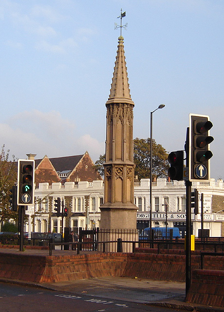
Cross (destroyed): OS Grid Reference – TQ 3180 8181
Archaeology & History
Site of Cow Cross on 1896 map
Not far from the long lost Fag Well could once be seen this old stone monument. Although not illustrated on the first Ordnance Survey maps of the inner city, it is highlighted on the 1896 edition (as shown here), just where Cow Cross Street meets Charterhouse Street—right by the boundary line—and is marked as ‘Site of Cow Cross’.
The cross gained its named from the cattle market that was held here from very early times, on the boundary of the lands of the Knights Hospitallers in the 12th century. Cattle itself–both horses and cows—were actually slaughtered at the market by the cross: a practice that has thankfully stopped (in public at least). Despite the place-name being referenced in many early accounts, actual descriptions of the cross are few and far between due to it being destroyed at quite an early date. When John Stow came to write his history of London in 1603, he told that it was no longer standing. Whether the cross replaced an earlier standing stone, we simply do not know…
References:
Gover, J.E.B., Mawer, Allen & Stenton, F.M., The Place-Names of Middlesex, Cambridge University Press 1942.
In truly that most unholy of places in England—Westminster, London—there was, in bygone times, a slightly more sacred site which, earlier still, might have been where a standing stone stood…. Might…. But such days are long gone down there. A gathering place of local people in very early times, the Broken Cross was, according to Vallance (1920),
“erected by the Earl of Gloucester in the reign of Henry III (1216-1272), but it did not stand very long. Its site is said to have been ‘the place of the meeting of the Folkmote…near St. Martin’s-le-Grand, about midway between the Northgate of the precinct (of St. Paul’s) and the church of St. Vedast.’ On 5th September 1379, agreements were drawn up for letting the stations about the Broken Cross to five divers persons. The cross was bodily taken down in 1390.”
Yet its name was maintained in street-names for many years later, simply as ‘Broken Cross’. Its position would have been very close to Cheapside.
George Gomme (1880) pointed out that such early folk moots were the development of tribal gatherings grafted from megalithic meetings onto early christian assemblies, pointing out how such assemblies for laws and councils were made at nearby St. Paul’s as early as 973 AD.