From the red phone-box at the road junction in Strathtay village, walk aling the road, east (slightly downhill) for less than 50 yards then turn left and walk up the track. After 70-80 yards, keep your eyes peeled for the footpath that runs up the slope into the tgrees (don’t head to the house in front of you). After a half-mile you reach the gorgeous old Tullypowrie farmhouse on your left; keep walking uphill for another 300 yards until your reach a large tree on your left, above which, sat on some very low walling, you’ll see a small upright stone.
Archaeology & History
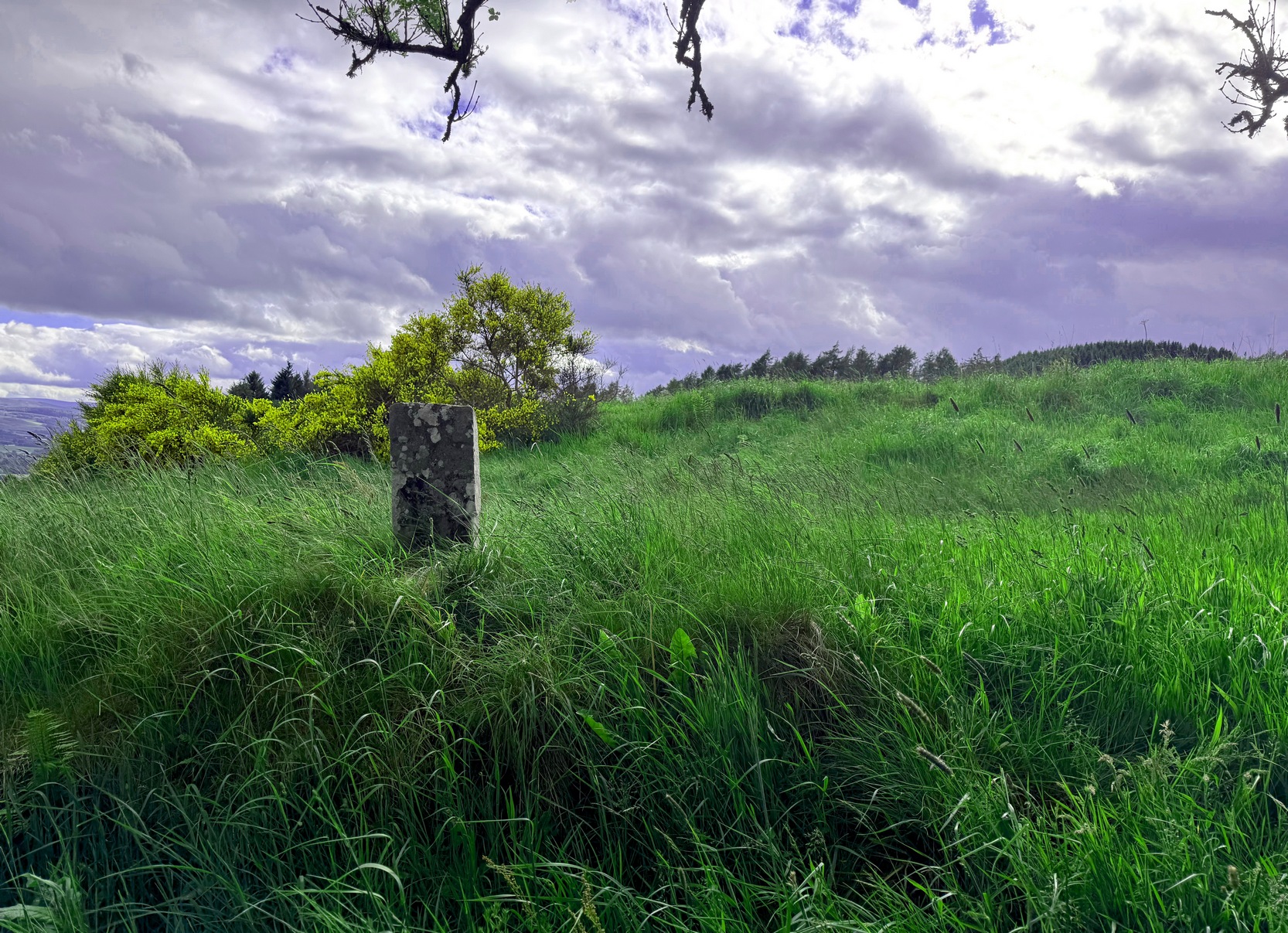
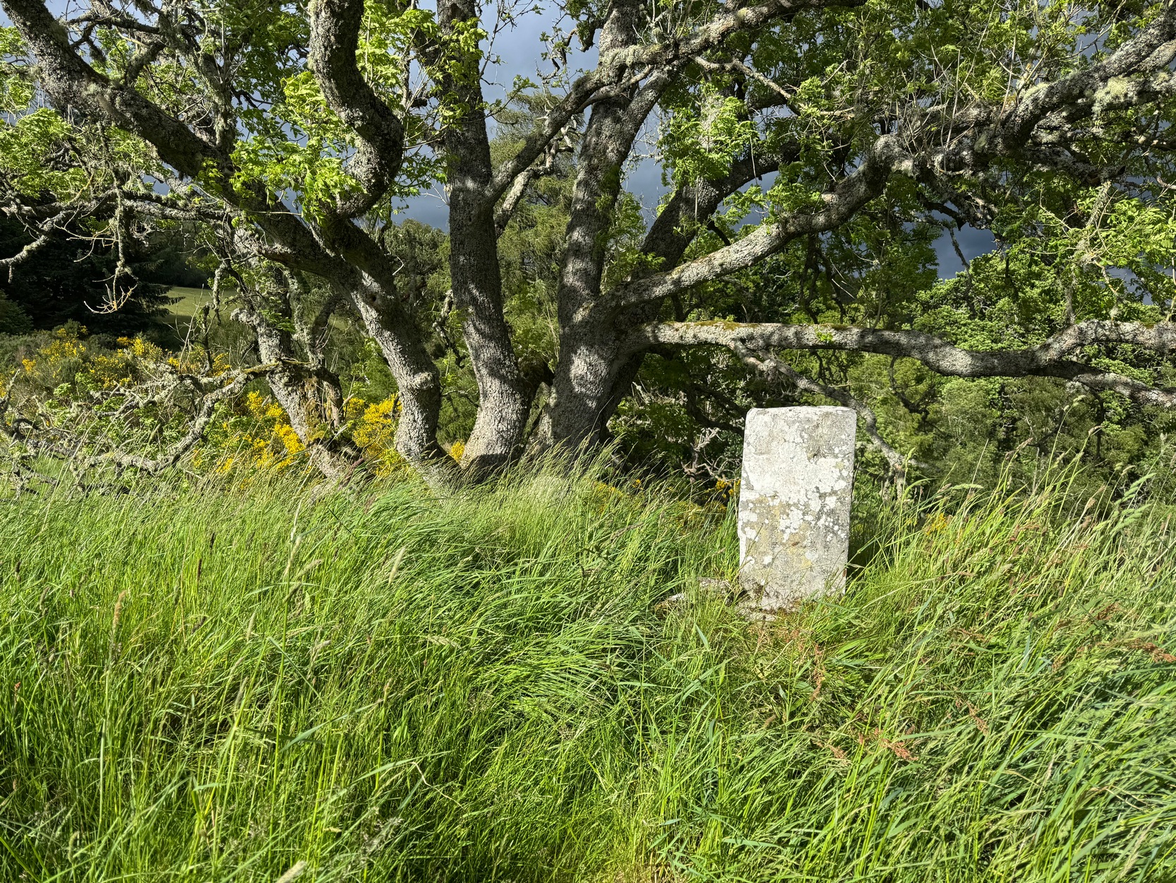
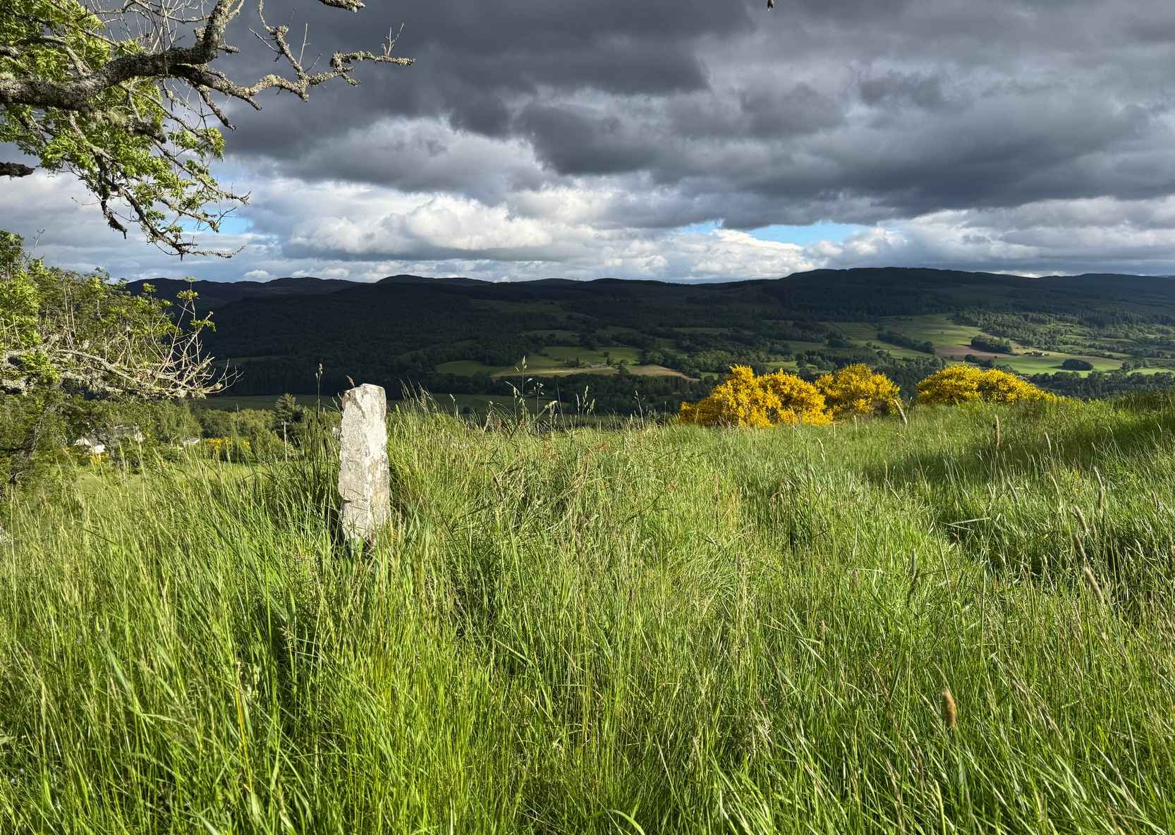
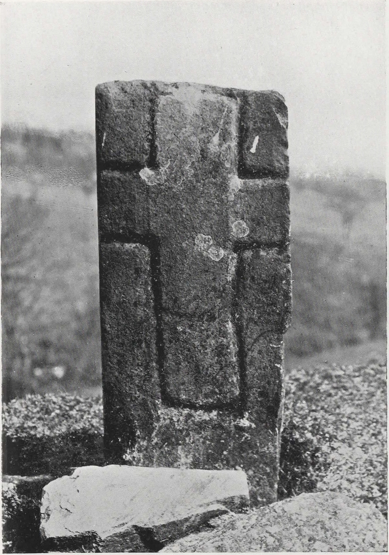
Faint cross on western face
This little-known early christian carved stone, sitting on the vague remains of an old Roman Catholic church, located on what local folks used to call “the route to the stones” (meaning to the Clachan an Diridh, much to the minister’s considerable disdain), has had less said of it than the more ancient stone circle a little further up the footpath. But then, not much is known of either the carving or the church itself, whose remains can barely be seen amongst the grasses. But the upright ‘cross’ at least proclaims itself to the eye.
On our recent visit here, the crosses (on both side of the stone) were somewhat faint, as my photos show. But it wasn’t always this way. During a visit to nearby Aberfeldy in September 1900, the antiquarian Dave Landsborough (1901) found himself ambling about “among the ruins of a small hamlet” that was the olde settlement of Tullypowrie and came upon this little-known monument. He subsequently wrote an excellent description of the stone, which cannot be equalled. “The cross,” he told,
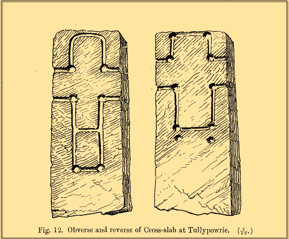
Landsborough’s sketch
“is of the rudest character, consisting of a schistose slab 30 inches in length, 11⅜ inches in width at the top, about half an inch wider at the bottom, and about 4½ inches in thickness. It is roughly squared at the top and sides, but at the bottom the base is unsquared, one side being longer than the other. On both faces of the slab a cross is formed by a shallow incised sinking, a little more than an inch in breadth, with circular sinkings slightly deeper than the rest of the outline at each corner of the shaft and summit of the cross, and at the intersections of the arms with the shaft and summit. The cross on the east face of the stone has its top almost level with the top of the slab, but the shaft does not reach nearly to the bottom. The top part of the cross above the arms is 4½ inches high by 4½ inches in width. The arms reach across the whole width of the slab, and the shaft is little more than the length of the part above the arms, the base being somewhat rounded. Below the termination of the shaft are two slight circular sinkings almost in line with the perpendicular outlines of the sides, but at unequal distances from their terminations, the one being 1½ inches and the other 2½ inches below the similar sinkings which mark the corners of the shaft. The cross on the west face of the slab is in every way similar, except that the shaft is longer, reaching to a length of 10½ inches below the arms, and the circular sinkings at the top are nearly effaced. It has, however, the curious feature of a slight cut-off at about the same length as the shaft of the other cross, but the circular sinkings occur at the top and bottom, and at the intersections as in the case of the other cross.
“The slab is not fastened in a socket, but is kept nearly erect leaning against a large stone, while smaller stones keep it firm at the back. I have since been told by the Rev. Mr McLean of Grandtully that the place where it stands is the site of an old and very little chapel, the south wall of which may still be recognised by its remaining foundations.”
Tullypowrie cross looking SDixon’s old photo
On the other side of the burn from here was the great Whooping Cough Well, with the heathen Clach na Buidseach against the wall of Tullypowrie Farm just below (subsequently moved to the field west of the cross). These sites (and others nearby) and the animistic traditions associated with them, probably had something to do with the positioning of the church here, and the cross would be the attempt to give a Christian veneer to usurp the more archaic natural practices. We don’t know that for sure, but it’s more than likely. The old Logierait schoolmaster James Kennedy (1927) makes constant references to the animistic lore of the region, which was legion until quite recently.
No additional lore, sadly, is known of this old cross, which is deemed to be medieval in origin. Both Mitchell (1923) and Dixon (1925) make mention of the monument in their respective guidebooks, but add no further information.
References:
Dixon, John H., Pitlochry, Past and Present, L. Mackay: Pitlochry 1925.
Kennedy, James, Folklore and Reminiscences of Strathtay and Grandtully, Munro Press: Perth 1927.
Landsborough, David, “Rubbings of both Faces of an Erect Incised Cross-slab, at Tullypowrie, near Grandtully, Perthshire,” in Proceedings Society of Antiquaries, Scotland, volume 35, 1901.
Mitchell, Hugh, Pitlochry District: Its Topography, Archaeology and History, L. Mackay: Pitlochry 1923.
Cup-Marked Stone (lost): OS Grid Reference – NT 3202 3347
Archaeology & History
In 1974, Ordnance Survey reported the existence of “a large piece of sandstone containing two depressions resembling cup marks” in the churchyard wall which, tradition told, originally came from the ruined 12th century parish church (long gone) more than 300 yards to the southwest (at NT 3185 3328). However, in recent years the cup-marks seem to have disappeared and may be hiding behind the overgrowth of ivy in the boundary wall. It needs to be recovered.
Halfway between the location of the original church and the present one, waters from the heathen St Bryde’s Well used to flow, but it had already been drained by 1856.
Holy Well (destroyed): OS Grid Reference – NO 180 452
Archaeology & History
The Well Meadow in the middle of Blairgowrie was once the place where the 5th century Apostle of the Southern Picts, or St Ninian, baptised local folk into the so-called “new faith”. It’s long since gone. The local historian John MacDonald (1899) told that it was located opposite the buildings on the north-side of the square, adding:
“St Ninian, one of the earliest Christian Celtic missionaries, on his tour through Scotland, pitched his camp where the Wellmeadow now is, and quenched his thirst at an old well or spring which ever afterwards bore the name of “St Ninian’s Well,” until it was covered in and the water led into the town drains.”
Cross (destroyed): OS Grid Reference – NJ 3755 4408
Also Known as:
St Fumac’s Cross
Archaeology & History
In the ancient tiny hamlet of Botriphnie, local historian J.F.S. Gordon (1880) told us that:
“About 40 years ago, a Cross of rude picked stone, in low relief, and about 5½ feet high, by about 3 feet broad, stood within the Kirkyard of Botriphnie. Unfortunately, about the time indicated, the Stone was broken up by a Blacksmith, who used it as a Hearth for his Smiddy! This had probably been the ancient Cross of St Fumack’s Fair of Botriphnie.”
This little-known saint has a feast day of May 3, when curious ceremonies were performed in and around his holy well, found just outside the churchyard to the northeast. Little is known about Fumac, but he was said to have been the first Christian missionary in this part of Scotland.
References:
Gordon, J.F.S., The Book of the Chronicles of Keith, Grange, Ruthven, Cairney and Botriphnie, Robert Forrester: Glasgow 1880.
Holy Well (destroyed): OS Grid Reference – TQ 332 911
Also Known as:
My Lady’s Hole
Archaeology & History
Long since gone after drainage operations on Tottenham Cemetery made the waters dry-up, this was one of several holy wells in the Tottenham area. Its history has been described in various old tomes, but the most definitive is found in William Robinson’s (1840) classic on the parish of Tottenham, when the well was still visible. He told us:
“There is a spring which issues from the side of a small hillock on the south side of the Moselle, nearly opposite the Vicarage, leading thence to the Church, called Bishop’s Well. This spring was formerly considered famous for many strange and wonderful cures performed on the diseased by the use of this water. It has been for some years neglected, but of late the owner of the field in which this well is, had it cleansed, and planted some trees round it, and put up posts and rails to prevent the cattle treading down the sides of it. It is said that the water of this well never freezes. In former times this well was in great repute from the purity of its water. The ladies in the vicinity of it were accustomed to send their servants in the morning and evening for water for their tea, from which circumstance it was for many years known by the name of “My Lady’s Hole.” The water of this well is not only esteemed for its medicinal qualities, but particularly for curing disorders of the eye.
“There were formerly many other springs about the village, especially one which issued out of the hill on which the Church stands; and another in Spottons Wood otherwise Spottons Grove, on the north side of Lordship Lane, which in the fifteenth century was of considerable notoriety; but none of which have in former times been so much frequented and held in such repute as Bishop’s Well.”
(Please note: the grid-reference for this site is an approximation)
References:
Foord, Alfred Stanley, Springs, Streams and Spas of London: History and Association, T. Fisher Unwin: London 1910.
Hope, Robert Charles, Legendary Lore of the Holy Wells of England, Elliott Stock: London 1893.
Holy Well (destroyed): OS Grid Reference – NS 6983 4138
Archaeology & History
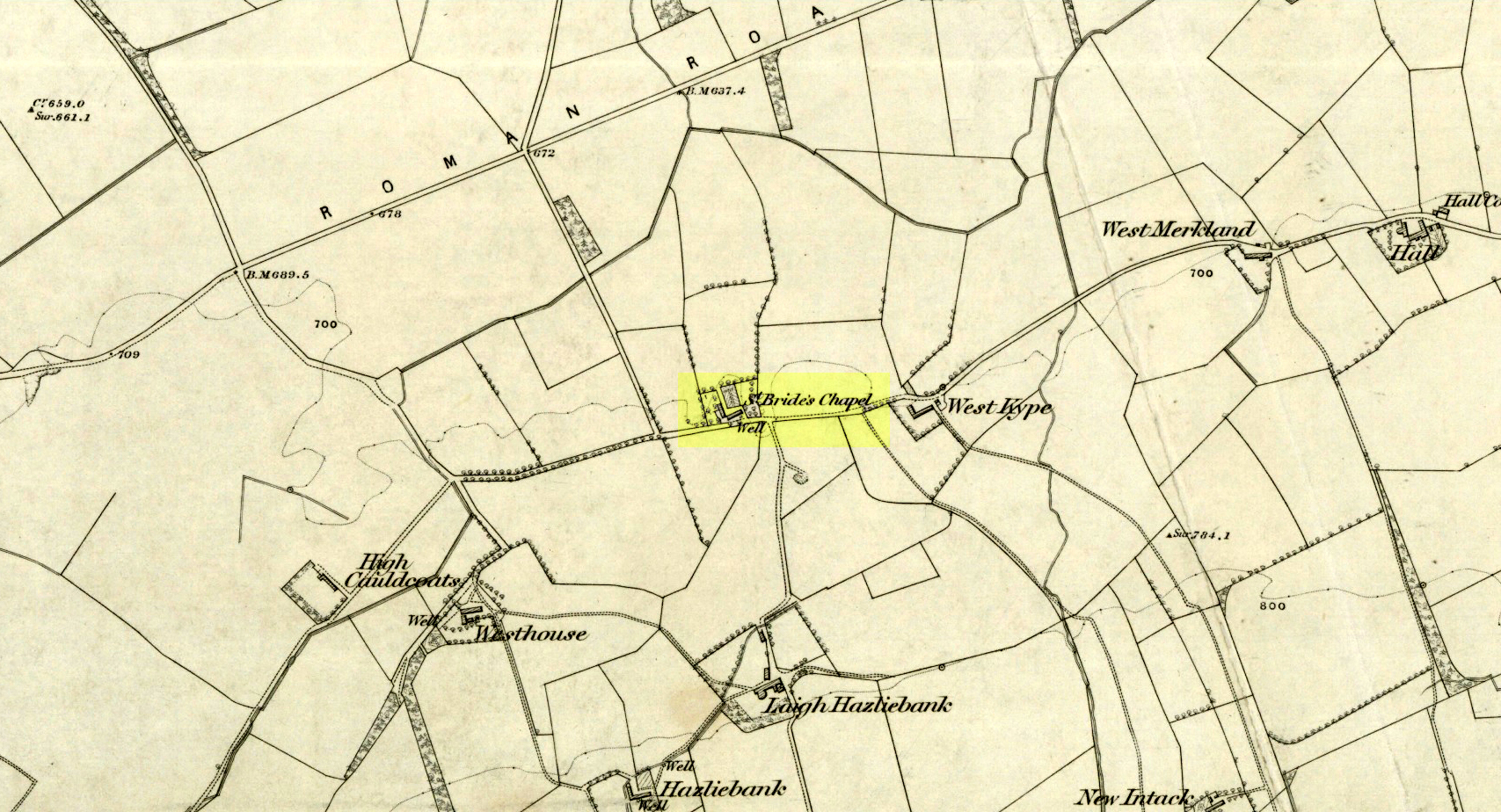
St Brides Chapel & Well on the 1864 OS-map
Shown on the 1864 OS map of the area as a ‘Well’ just at the front of St Bride’s Chapel—now a very pleasant old cottage—peasants and pilgrims would stop for both refreshment and ritual here as they walked down High Kype Road. Although the chapel was described in church records of January 1542 as being on the lands of Little Kype, close to the settlement of St Bride, there seems to be very little known about the history or traditions of the well. If anyone has further information on this site, please let us know.
Folklore
Bride or Brigit has her origins in early British myth and legend, primarily from Scotland and Ireland. Her saint’s day is February 1, or the heathen Imbolc (also known as Candlemas). Although in christian lore St. Bride was born around 450 AD in Ireland and her father a Prince of Ulster, legend tells that her step-father (more probably a teacher) was a druid and her ‘saintly’ abilities as they were later described are simply attributes from this shamanic pantheon. Legends—christian and otherwise—describe Her as the friend of animals; possessor of a magickal cloak; a magickian and a healer; and whose ‘spirit’ or genius loci became attached to ‘sacred sites’ in the natural world, not the christian renunciation of it. St Bride was one of the primal faces of the great prima Mater known as the Cailleach: the greater Gaelic deity of Earth’s natural cycles, whose changing seasons would also alter Her names, faces and clothes, as Her body moved annually through the rhythms of the year. Bride was (and is) ostensibly an ecological deity, with humans intrinsically a part of such a model, not a part from it, in contrast to the flawed judaeo-christian theology.
References:
Paul, J.B. & Thomson, J.M., Registrum Magni Sigilli Regum Scotorum: The Register of the Great Seal of Scotland AD 1513 – 1546, HMGRH: Edinburgh 1883.
Go north on the A5026 from the town of Holywell for about 3 miles; at the hamlet of Lloc take the turning first right towards Trelogan village for another mile – the ancient cross stands in the corner of a field at the junction of 3 roads at the turning from Whitford to Trelogan, halfway between Whitford and Sarn. The cross can also be reached via Pantasaph from the A55.
History
The cross probably dates from 1000 AD and is said to be the tallest wheel-headed cross in Wales, standing at 11 feet 3′ in height. The metal fence surrounding the cross spoils the monument quite a bit, but it is there for security reasons. It is richly decorated on all sides and on the cross-head. Much of the decoration is Celtic in origin, but there are also Viking influences here, probably Northumbrian. On the south face there is a human figure standing on a serpent that has associations with the Norse god Odin; also a three-legged horse that may also be connected to Odin. The north-west face has Celtic pattern-work in the form of the letter “X” and below that another figure (naked) holding a spear. The north-east face is rather eroded, but there is some Celtic-style decoration. There is more knotwork and chainwork elsewhere on the cross with other animal figures. The wheel-head has a distinctive central boss and a four star-shaped cross radiating from the boss.
Folklore and Legend
The cross is also called ‘The Stone of Lamentation’ because penances were carried out at the cross in the Middle Ages. This act would have concluded with weeping and the ‘act of contrition’ by pilgrims visiting the site whilst making their way between St Winifred’s Well and St David’s. Legend says that St Cwyfan, a local 7th century Celtic saint preached on this site and set-up the cross – hence the name, Maen Achwyfan. One local legend tells us that Queen Boudica fought her last battle against the Romans close by in the fields called ‘Cydio ar Leni’ or ‘The fields of the seizing legions’. During the Middle Ages the monks of Basingwerk Abbey preached at the cross and also set up a chapel for pilgrims just to the south at Whitford.
References:
Allen, J. Romilly, “Celtic Crosses of Wales”, in Archaeologia Cambrensis, 1899.
Owen, Rev. Elias, Old Stone Crosses of the Vale of Clwyd and Neighbouring Parishes, Bernard Quaritch: London & Oswestry 1886.
Sharkey, John, Celtic High Crosses of Wales, Carreg Gwalch: Llanrwst 1998.
Westwood, J.O., Lapidarium Walliæ – The Early Incised and Sculptured Stones of Wales, Oxford University Press 1879.
From Kelbrook village head south past Old Stone Trough then continue as far as the lane goes. Then head eastwards for about 1 mile on footpaths to a building called Laycocks. From here continue east along footpaths for another 1 mile or so until you reach Copy House (now called Hawres Farm). Go to the back of the farm where you will see in the wall a cross-incised boundary stone. At the side there is a square-shaped holy well. (You may need to ask permission at the farm).
Archaeology & History
Dissenters Well & Cross (image courtesy ‘QDanT’)
The so-called Dissenters’ Well is a rectangular feature in the ground next to the wall. It is said locally to date from the 17th-18th century, but is most probably an ancient moorland spring. The well was in use from the 17th century by Quakers, Baptists, Methodists and possibly Roman Catholics, at a time when there was much animosity towards non-Conformists. Legislation was passed stopping all illegal gatherings to be held within a 5 mile radius of any church – thus leading to religious gatherings in bleak, remote places on the moorland above towns and villages. In 1812 an Act of Parliament against non-Conformists was repealed and dissenters were given equality regarding where they could worship. The water in the well no doubt had some medicinal qualities or, was a source of spiritual up-lift at the time.
By the well there is 3 foot high pointed boundary stone or waymarker known as ‘Tom’s Cross’ and it has a thin incised cross carved onto it. The stone is partly embedded in the wall. It probably marks the old boundary between Lancashire and Yorkshire. I don’t know who Tom was though he may have been the person who set up the stone. The age of the stone is not known.
Cross (destroyed): OS Grid Reference – SD 6573 9212
Archaeology & History
More than 150 years ago outside St. Andrew’s Church in Sedbergh, A.E. Platt wrote (1876) that,
“there was a cross standing in the Market Place adjoining the churchyard on the north, but the last remains of it, and the stone steps it stood on, were taken away some years since by private persons, and may now be seen used as gateposts to a farmyard, some ten miles from their original position.”
Intriguing stuff! Does anyone know which farmyard might still possess these old relics? When the legendary Harry Speight (1892: 443) ventured by here fifteen years later he knew little about their new location, but simply echoed what Platt had previously written. It would be good to know what has become of them…
References:
Platt, A.E., The History of the Parish and Grammar School of Sedbergh, Yorkshire, Atkinson & Pollitt: Kendal 1876.
Speight, Harry, The Craven and Northwest District Highlands, Elliot Stock: London 1892.