Holy Well (destroyed): OS Grid Reference – NN 9397 5770
Archaeology & History
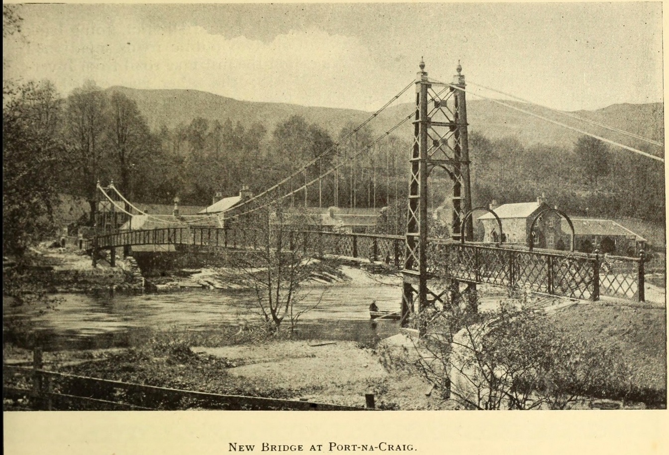
It was more than a hundred years ago that the waters of this sacred well fell back to Earth. They emerged above the eastern side of the River Tummel, close to the bridge where previous there had been a local ferry at the site known as Port-na-Craig. The mythic history of the ferry and the holy well went hand-in-hand, according to local tradition. Its lore was was spelled out by the local author and historian Hugh Mitchell in a speech he gave when a new bridge was opened here in 1913. He said:
The Well was on the far side of the bridge
“The ferry at Port-na-Craig, though not as old as many ferries in Scotland, bears the respectable antiquity of something like eight hundred years. It was established by the monks of Coupar Angus when they got a gift of the lands of Fonab, and as Coupar Angus lay on the north side of the river Tummel, they established the ferry in order to have communication. In those days the ferry boat was made of skins stretched on branches or twigs, so it was somewhat dangerous to cross in, and the monks thought that they would improve the occasion by dedicating the well near the old ferry to St. Bride, so that people, when they ventured across the ferry, might propitiate the saint. It was customary for people to drop either a small coin or a brass pin into the well. He was afraid that brass pins rather prevailed, and no doubt, St. Bride, being a lady, would find them more useful. The well remained until recent times, when it had, unfortunately, to be filled up, on account of being contaminated by neighbouring fields.”
For “fields”, read sewage—for that was the actual reason it was closed. Mr Mitchell (1923) told as much in his subsequent history of Pitlochry, saying that “sewage was percolating into it.” John Dixon (1925) echoed the same thing a few years later.
The curative and magickal properties of St Bride’s Well had considerable renown for local people. Mitchell told that:
“It had a great reputation at one time for cases of lung disease… Pins and coins were dropped into the well as votive offerings, and the bushes above it were hung with rags to call the attention of the saint to the sufferer.”
A few miles north from here, at the back of Blair Castle, an old church is dedicated to St. Bride, whose celebration date is February 1. “The day was known as Candlemas in the Highlands,” wrote Mrs Banks, saying, in commemoration of the Celtic Brigit, “Feill Bride, the festival of Bride, displaced the festival of Mary.”
References:
Dixon, John H., Pitlochry, Past and Present, L. Mackay: Pitlochry 1925.
MacKay, L., Atholl Illustrated, L. MacKay: Pitlochry 1912.
Mitchell, Hugh, Pitlochry District: Its Topography, Archaeology and History, L. Mackay: Pitlochry 1923.
Stone Circle (destroyed): OS Grid Reference – NN 857 489
Archaeology & History
In an early essay on the rock art around Aberfeldy, Hugh MacMillan (1884) remarked on what he thought was a tumulus on the southern slope above the town and where a large old petroglyph once lived. Subsequently (MacMillan 1901), in his beautiful artistic foray through upper Tayside, he revised his earlier remarks telling that:
“On the side of a high, tree-covered hillock, rising up abruptly behind the central part of Aberfeldy, called the Tullich, there was once a Druidical circle, one of the huge stones of which, called the Clachmore, forms part of a garden wall on the old military road passing along its base.”
The circle was mentioned in Mackay’s (1954) excellent work, albeit in the past tense, and he could add no more to it other than his memory of the whereabouts of the Clach Mhor (as it was more accurately known), on which were numerous cup-markings. (Note: the grid-reference to this site is an approximation)
Folklore
In bygone times the people of Aberfeldy observed the celebration of Samhain, the old pre-christian New Year’s Day—a.k.a. Hallowe’en—on November 11th. Interestingly for us, “bonfires were numerous and there was always a great blaze on the Tullich,” said Dr John Kennedy. (1901) Considering the small area of The Tullich, it would be unusual if such festivities did not have some relationship with the stone circle. Samhain relates primarily to the passing over of the dead in the cycle of the year: the spirits of the ancestors moving through the worlds. If this circle had such a relationship with the bonfires, it may have been a ring cairn and not a free-standing stone circle.
References:
Kennedy, John, Old Highland Days, Religious Tract Society 1901.
Mackay, N.D., Aberfeldy Past and Present, Town Council: Aberfeldy 1954.
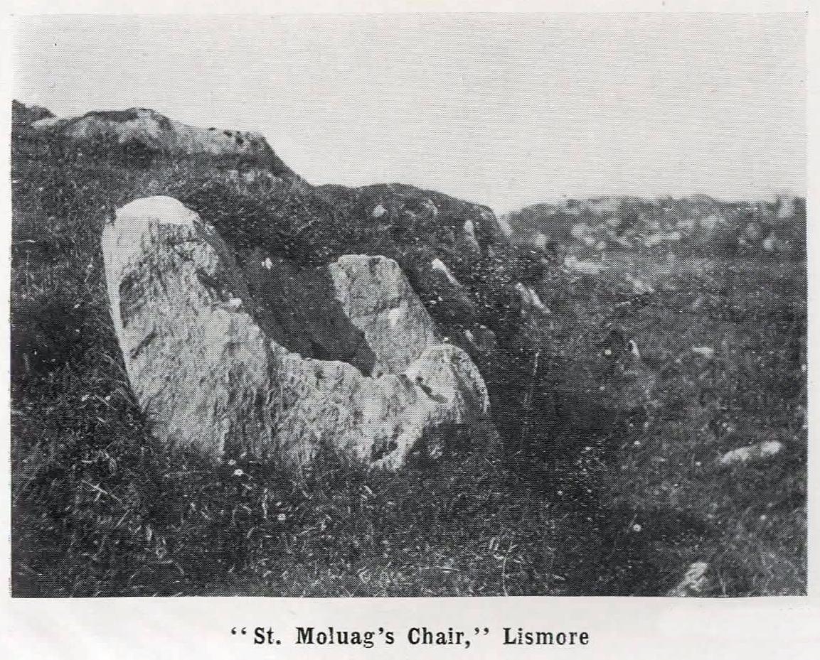
From the Port Appin ferry onto the northern tip of the island, go along the B8045 road for literally 3.5km (2.17 miles) and, shortly after passing Achuaran, a single small white house is on your right. Just yards before here is a small raised rocky knoll. …Or from the Achnacroish ferry, up the road for nearly a mile, then turn right along the B8045 road to Clachan. A half-mile past the hamlet, go past the old School House, then past Mountain View cottage, and the next small white house on the left has a rocky knoll just past it. Just over the wall from the road, a sign points out the legendary Chair that you’re seeking!
Archaeology & History
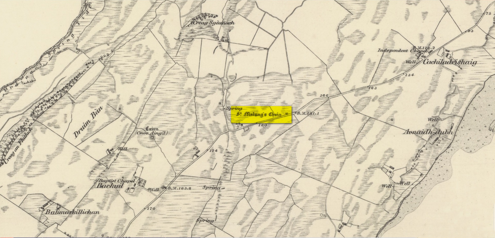
Site shown on 1875 map
St Moluag, a contemporary of the renowned St Columba, was a 6th century Irish saint who came to reside on Lismore—“the sacred isle of the western Picts”—and here taught the early christian doctrines, fused with indigenous animistic traditions. He used sites of Nature as places of reflection and meditation and this chair-shaped boulder came to be a place renowned as one of his ritual sites, not far from his church. It was described in Frank Knight’s (1933) huge work as possessing healing properties:
“To sit in it used to be considered a sovereign remedy for rheumatism.”
The site was highlighted on the earliest Ordnance Survey map of the island and its lore was remembered by local people of the time. The chair had wider ‘arms’ until the beginning of the 20th century when in widening the road, they were accidentally broken off by one of the workmen.
References:
Knight, G.A. Frank, Archaeological Light on the Early Christianizing of Scotland – volume 1, James Clark: London 1933.
Acknowledgements:Huge thanks for use of the Ordnance Survey map in this site profile, reproduced with the kind permission of the National Library of Scotland.
Healing Well (destroyed): OS Grid-Reference – NT 2547 7337
Archaeology & History
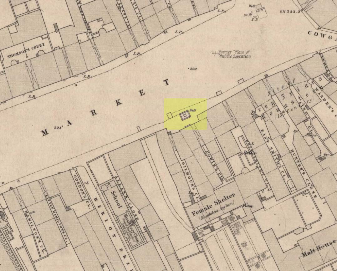
Muses ‘Well’ on 1852 map
We have the historical detective work of Stuart Harris (1996) to thank for the location and probable meaning behind the name of this long-lost well, that could once be seen along Haymarket, near the heart of the old city. Shown on the 1852 OS map, without name, the site was recorded as a public well “from 1502 onwards,” he wrote — and its name was variably written as muse, muss, meus and mwse, which led him to surmise that it was from the old Scots word “meuse”, or the “well by the stables”; although I cannot find this validated in the established dialect dictionaries and glossaries of William Grant (1934-76) or Simon Taylor (2012). Their relative definitions tell it to be of a mouse, or a small trackway left by rabbits, hares or rodents, running between hedgeways. This would mean the ‘Muse Well’ was a variant around a “well by an animal track”, which in earlier centuries were very important to note, as wild animals were indicators of food (amongst other things).
This aside, “the King’s Stables, dating from the 1340s, were of course over 200 yards further west,” he wrote,
“but the convent of the Greyfriars, founded in 1471 in the Cowgatehead only about fifty yards east of the Muse Well, certainly gave lodging to travellers of the more distinguished sort, and although no early record of stables here has come to light, it may be no accident that the only stables recorded in the Valuation Roll of 1635 as being on the south side of Grassmarket were in McIntyre’s Close, which had its entry ten yards east of the Well.”
References:
Grant, William (ed.), The Scottish National Dictionary – 10 volumes, SNDA: Edinburgh 1934-76.
Harris, Stuart, The Place-Names of Edinburgh: Their Origins and History, Gordon Wright: Edinburgh 1996.
Taylor, Simon & Gilbert, Markus, “Elements Glossary”, in The Place-Names of Fife – volume 5, Shaun Tyas: Donington 2012.
Along the A81 road from Port of Menteith to Aberfoyle, watch out for the small road in the trees running at an angle sharply uphill, nearly opposite Portend, up to Coldon and higher. Keep going, bearing right past Mondowie and stopping at the dirt-track 100 yards or so further up on the left (ignore the english fuckers up here who tell you it’s a pwivate road and they don’t want you parking there—unless you’re blocking the road obviously!). Walk up up here for ⅔-mile, as if you’re visiting the Over Glenny (5) carving, but as you get close to the defining sycamore tree, walk past it for about 60 yards towards the ruinous buildings. You’re looking for a reasonably large earthfast rock with a notable bowl about 12-inch across at the edge of the stone. That’s your defining feature.
Archaeology & History
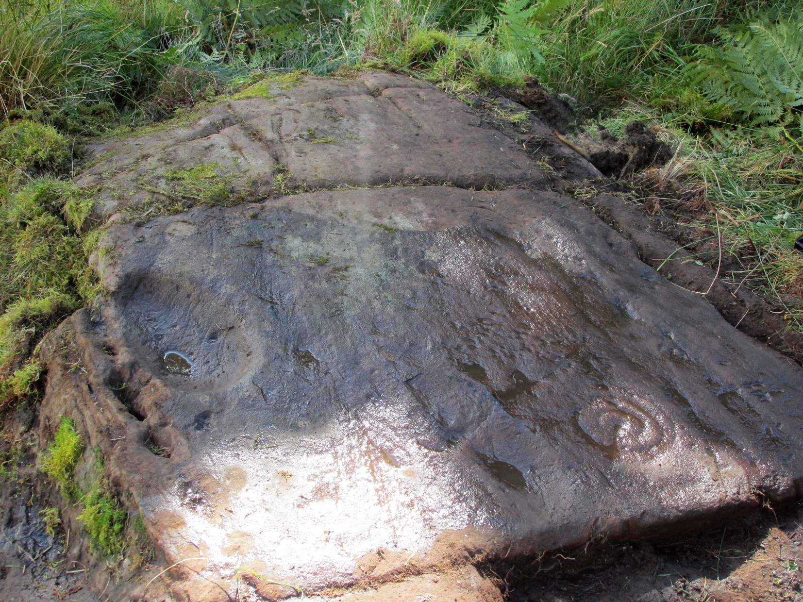
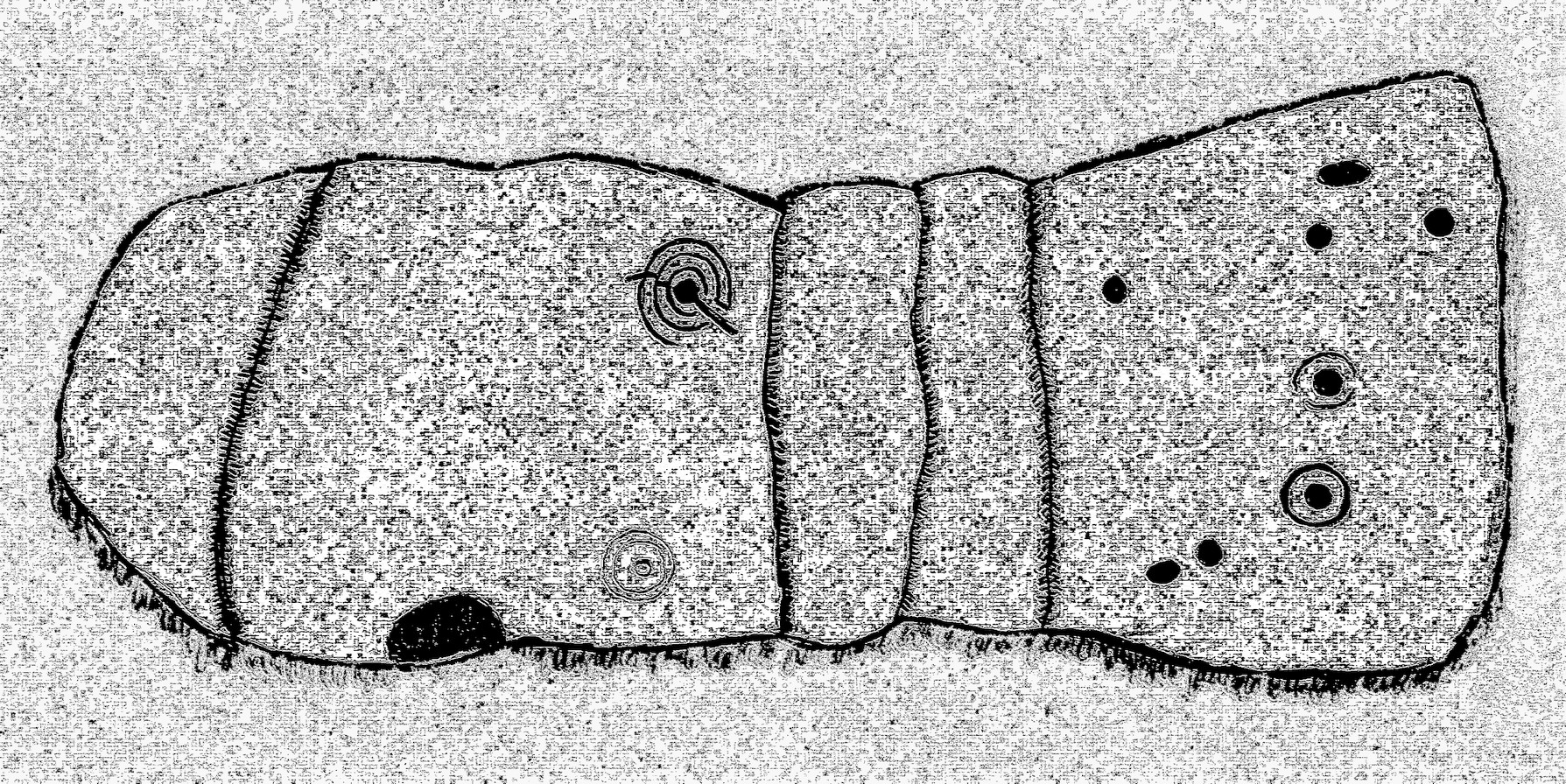
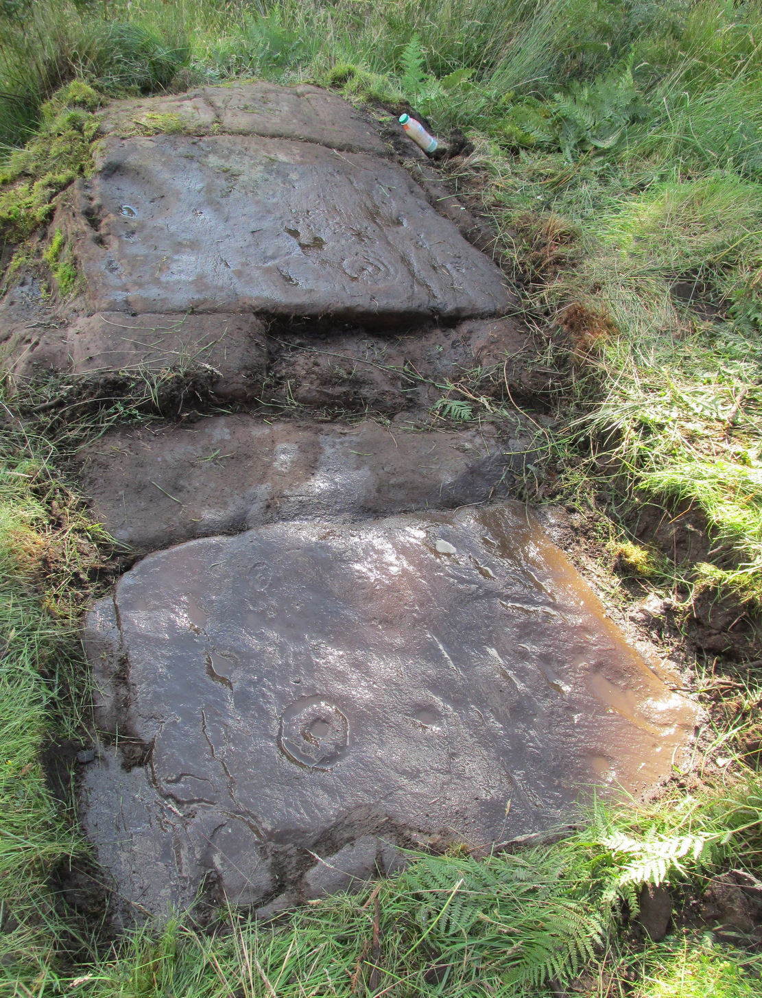
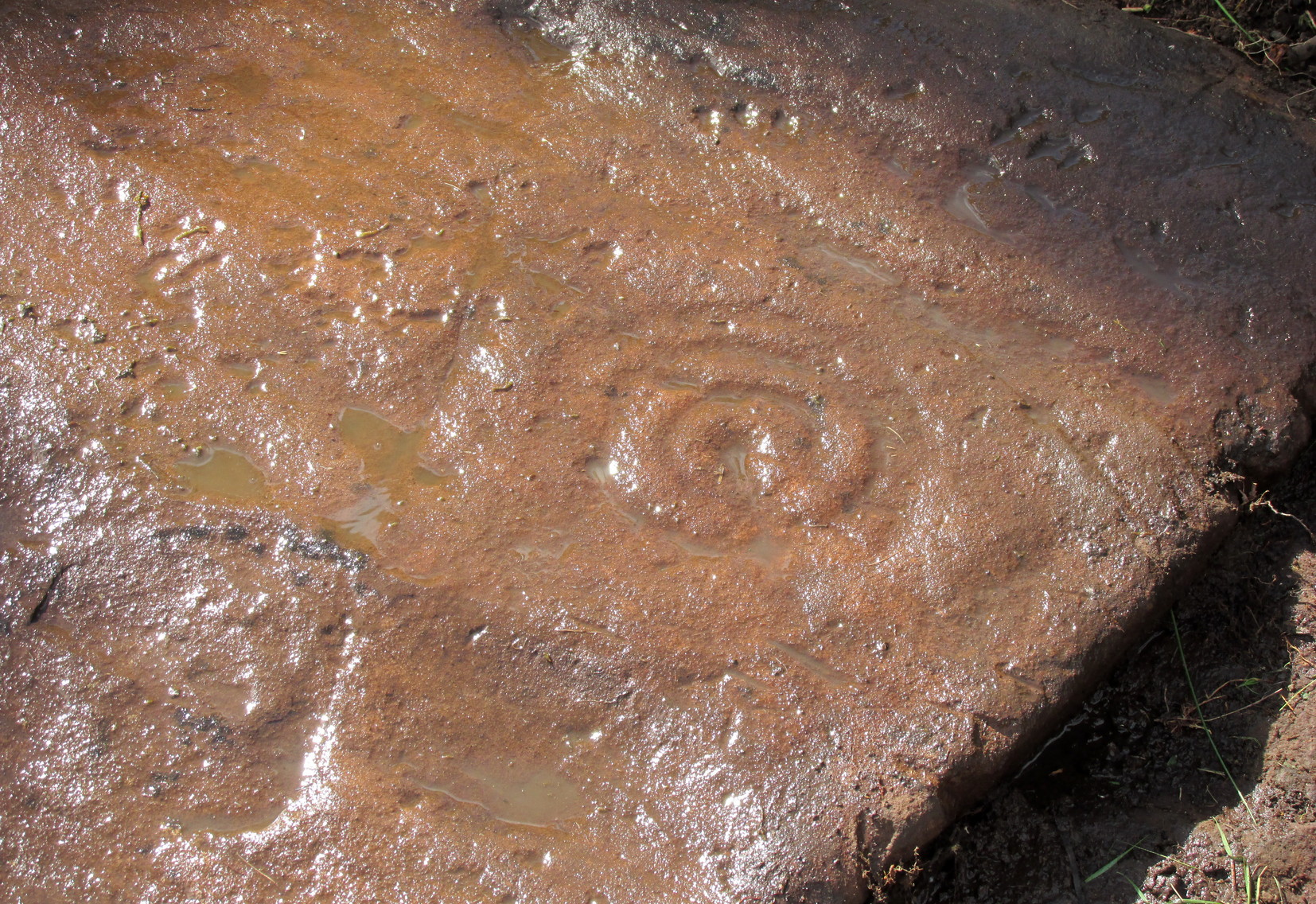
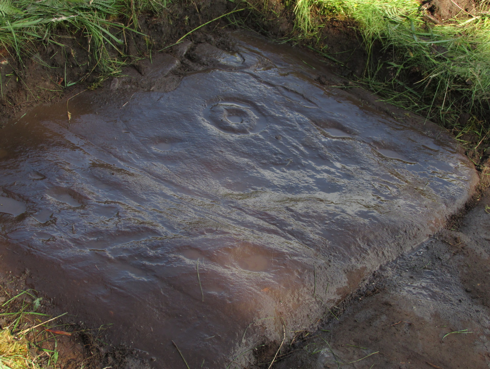
Arty sketch of the design
This is another decent design in the mass of petroglyphs on this plain overlooking the Lake of Menteith. On our first visit here ten yeas ago, only one half of the rock was visible—and half of that was covered with grasses! But with patience, we slowly rolled back the turf and slowly uncovered more and more, eventually seeing the main elements you can see in these photos and the arty sketch I’ve made here. (the Over Glenny [14] carving a few yards further east may be just be a continuation of this design)
Full length of the stoneThe triple cup-and-ring
When the carving was first noticed by George Currie (2010), he only noticed “a cup mark surrounded by two penannulars, an arc and a single radial”—ostensibly meaning, a cup-and-triple ring, with the outer ring incomplete, and a line running out from the central cup. But there’s more, obviously. On our second visit, a very faint but distinct cup-and-double-ring was noticed in low light on the same section of the rock where the triple-ringed element is carved. We weren’t able to get a photo that showed it, as the light wasn’t doing as we needed, but I’ve highlighted it on the sketch, where it’s to the right of the large ‘bowl’ at the very edge of the rock. This ‘bowl’ probably had utilitarian functions, whether it was for just crushing herbs or grains, or to make organic paints: and this function most likely had some relationship with the petroglyph—but we know not what! It’s possible that the people who lived in the adjacent ruin, several centuries ago, may also have made use of this.
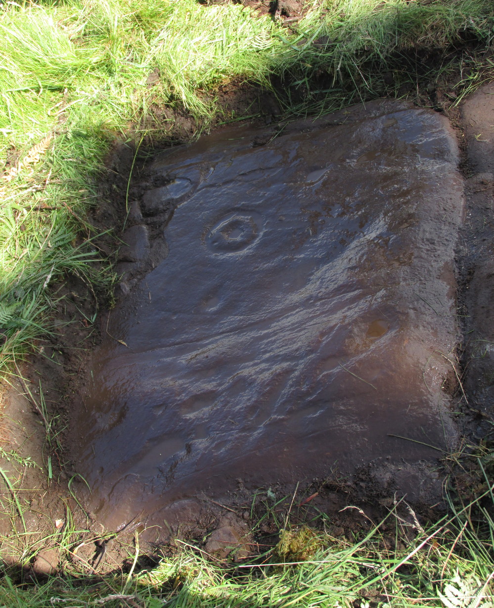
East-end of the designEast-end angular pose
When we exposed the other half of the carving, a very well-cut and well-preserved cup-and-ring sat beside another much more eroded partner, which was almost impossible to see from some angles. You can just make it out in the photos here. You’ll also notice a scatter of several other cup-marks and elongated ‘cups’ on the same section of rock. It was difficult to work out whether some of these marks in the stone were Nature’s handiwork, or the result of human hands. Some were obviously man-made, but we need to look at it again when the daylight conditions are good, so that we can make a more accurate assessment.
Currie, George, “Port of Menteith: Upper Glenny (UG 1), Cup-and-Ring Marked Rocks”, in Discovery & Excavation, Scotland, New Series – volume 11, 2010.
Acknowledgements:Huge thanks to the crew: Paul Hornby, Lisa Samson & Fraser Harrick in making this carving come to life, and for use of a photo or two.
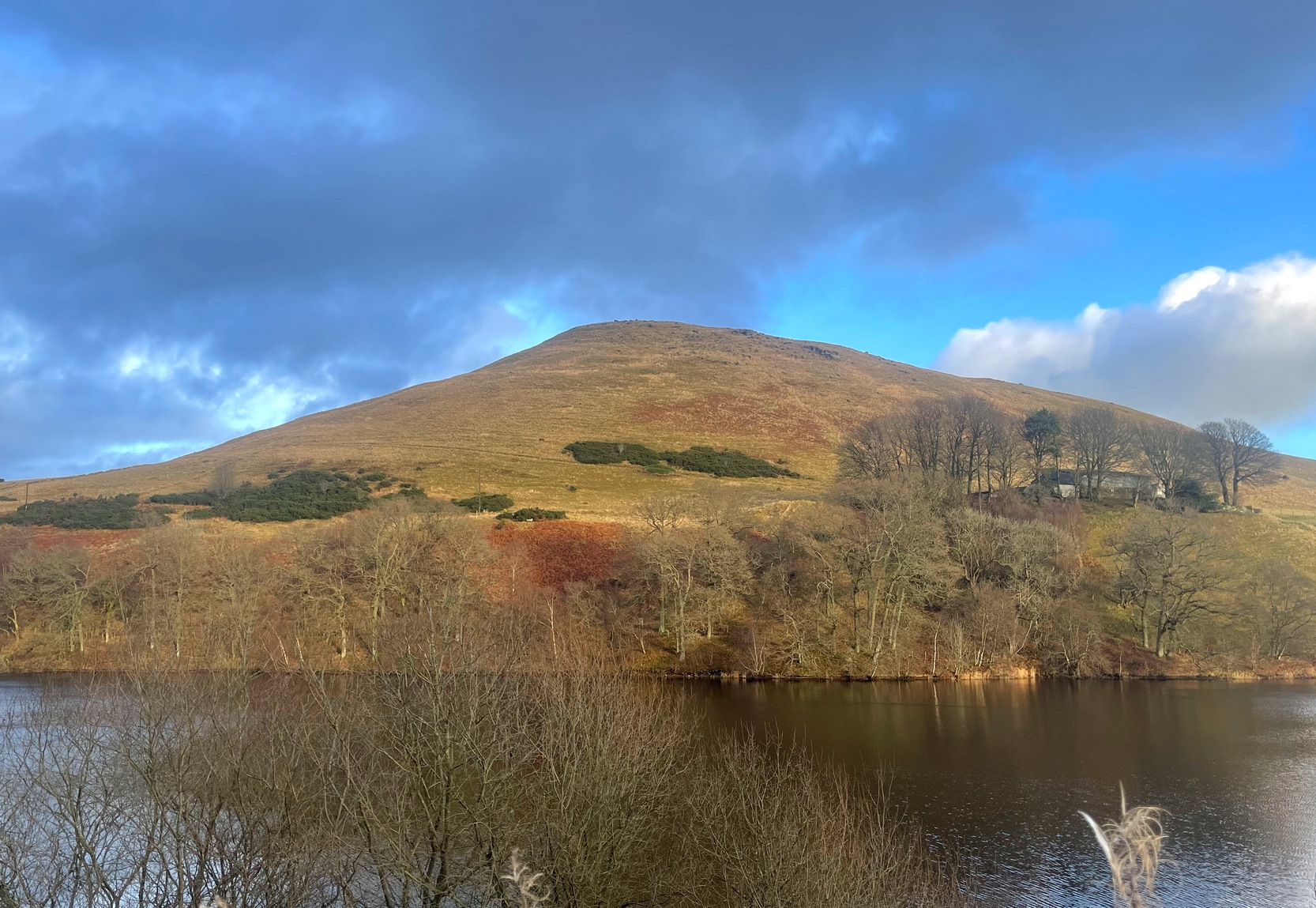
Travelling north along the A823 Glendevon road (between Muckhart and Gleneagles), barely 2 miles after Muckhart, on your right you’ll see the large Castlehill reservoir. Park here. Across the waters is the large Down Hill—which the hillfort crowns. So, just walk back the way you came along the road for nearly 600 yards and then turn left to walk onto the other side of the water, round to the very end of the track and then up the path into the trees. Walk along this winding path for 300 yards until you reach the track that takes you (left) up to Downhill Farm. One way or the other, past there, just stagger up to the top of the hill!
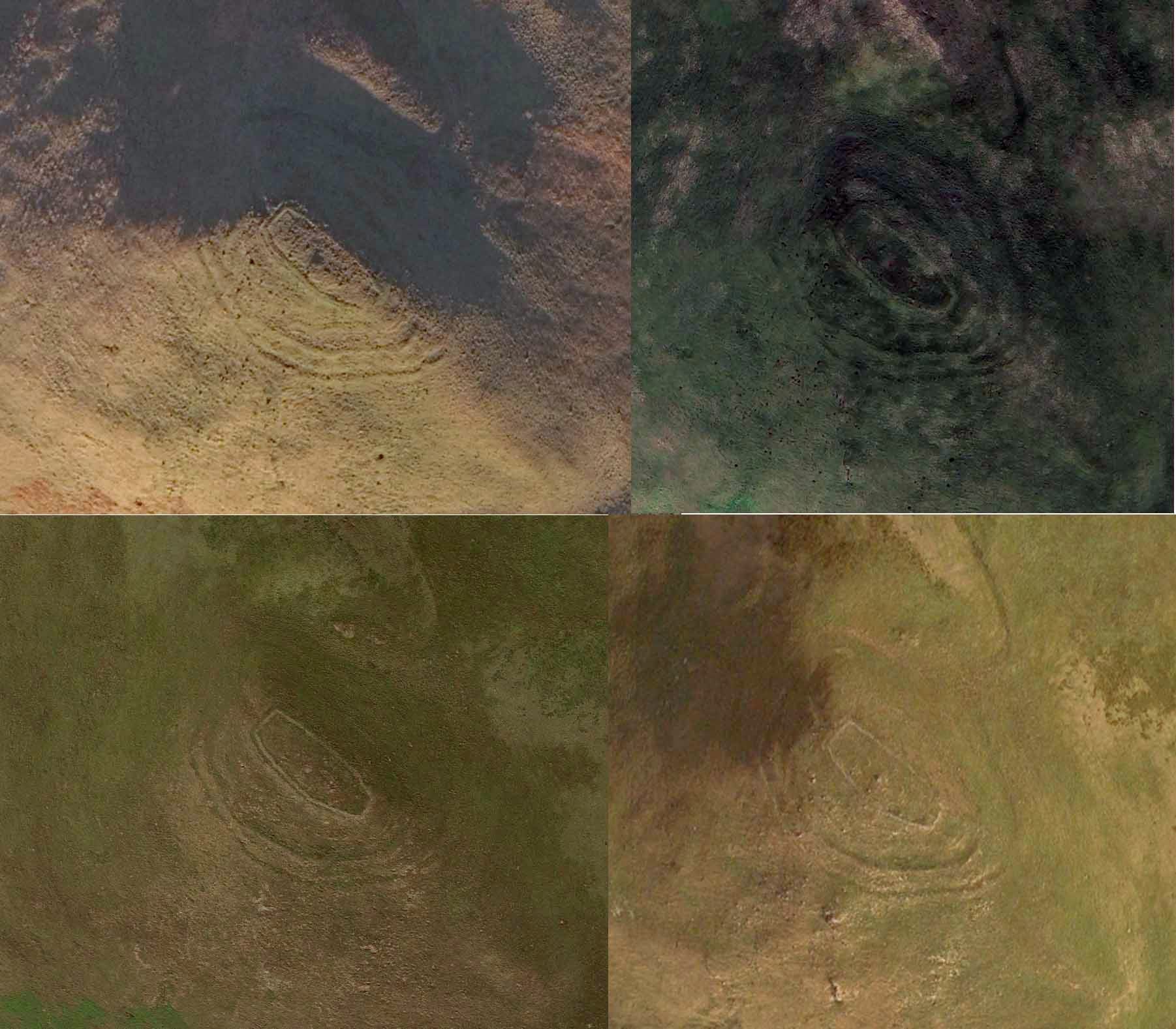
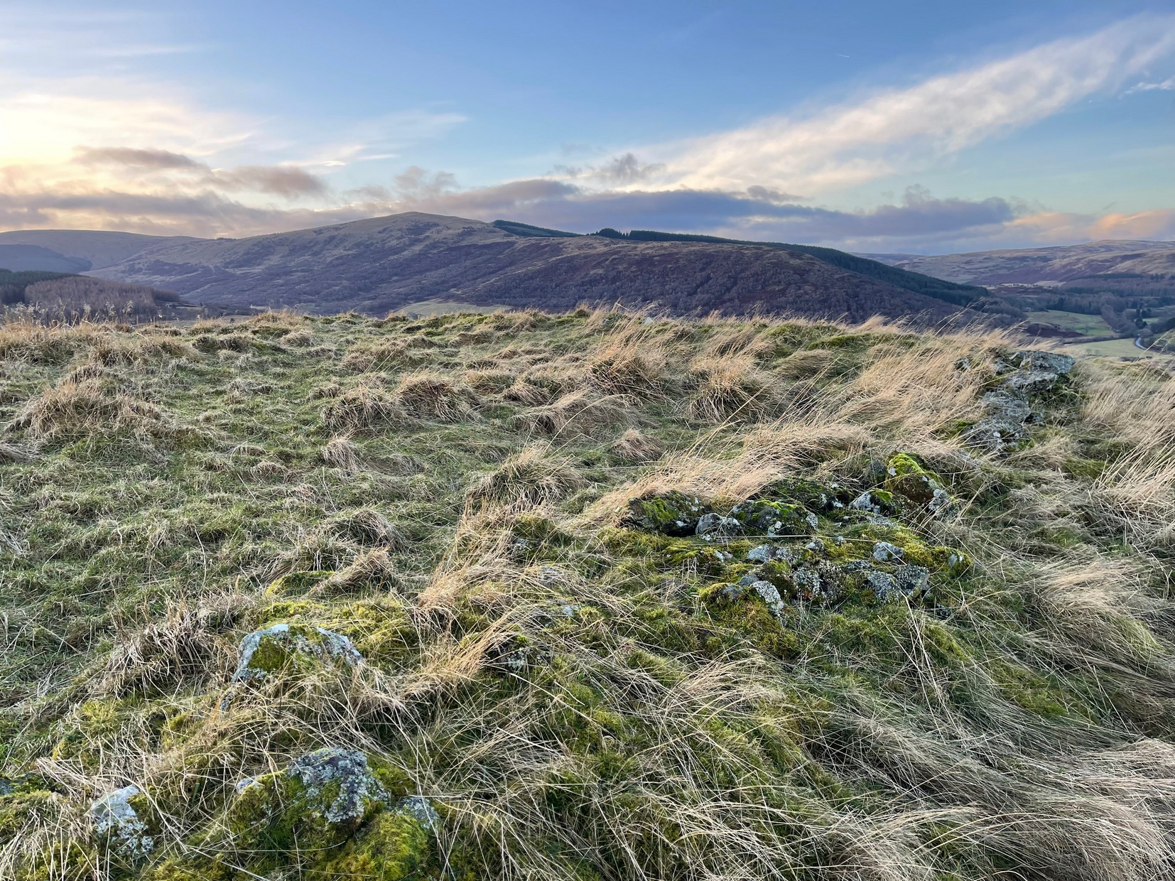
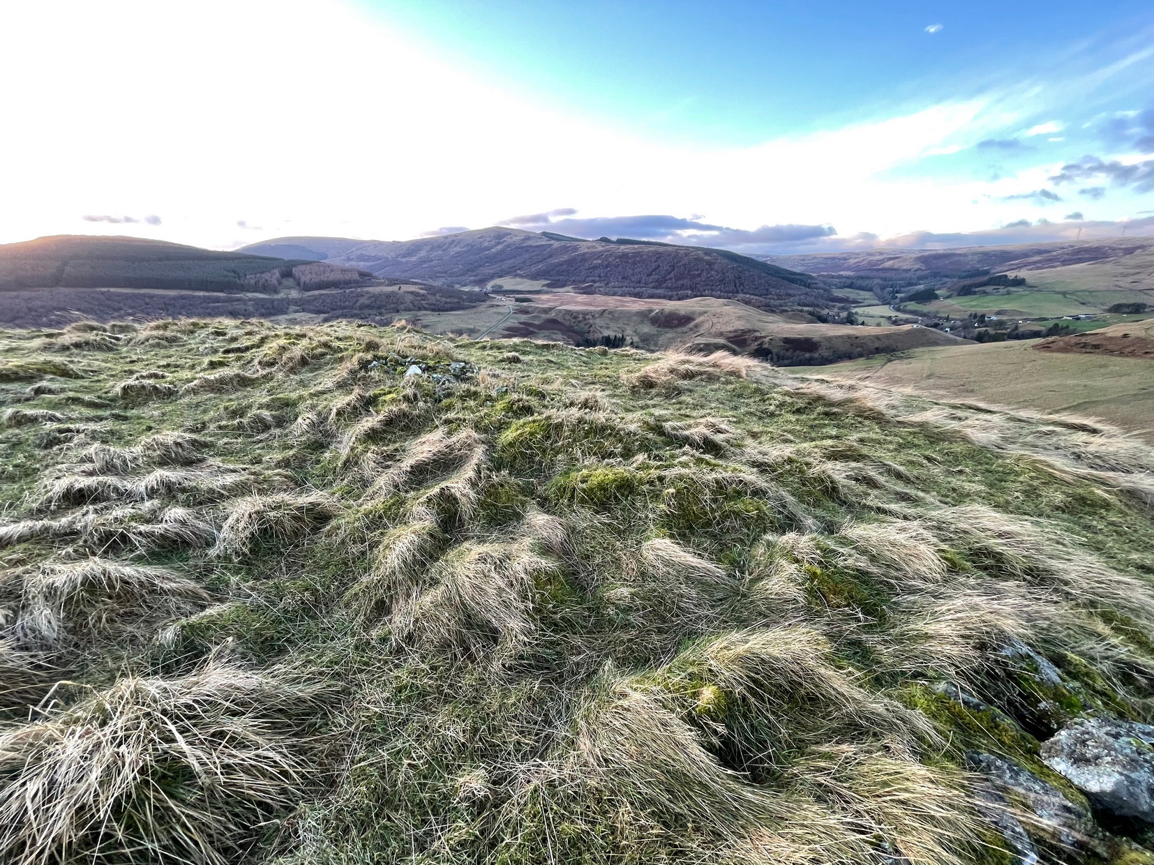
Archaeology & History
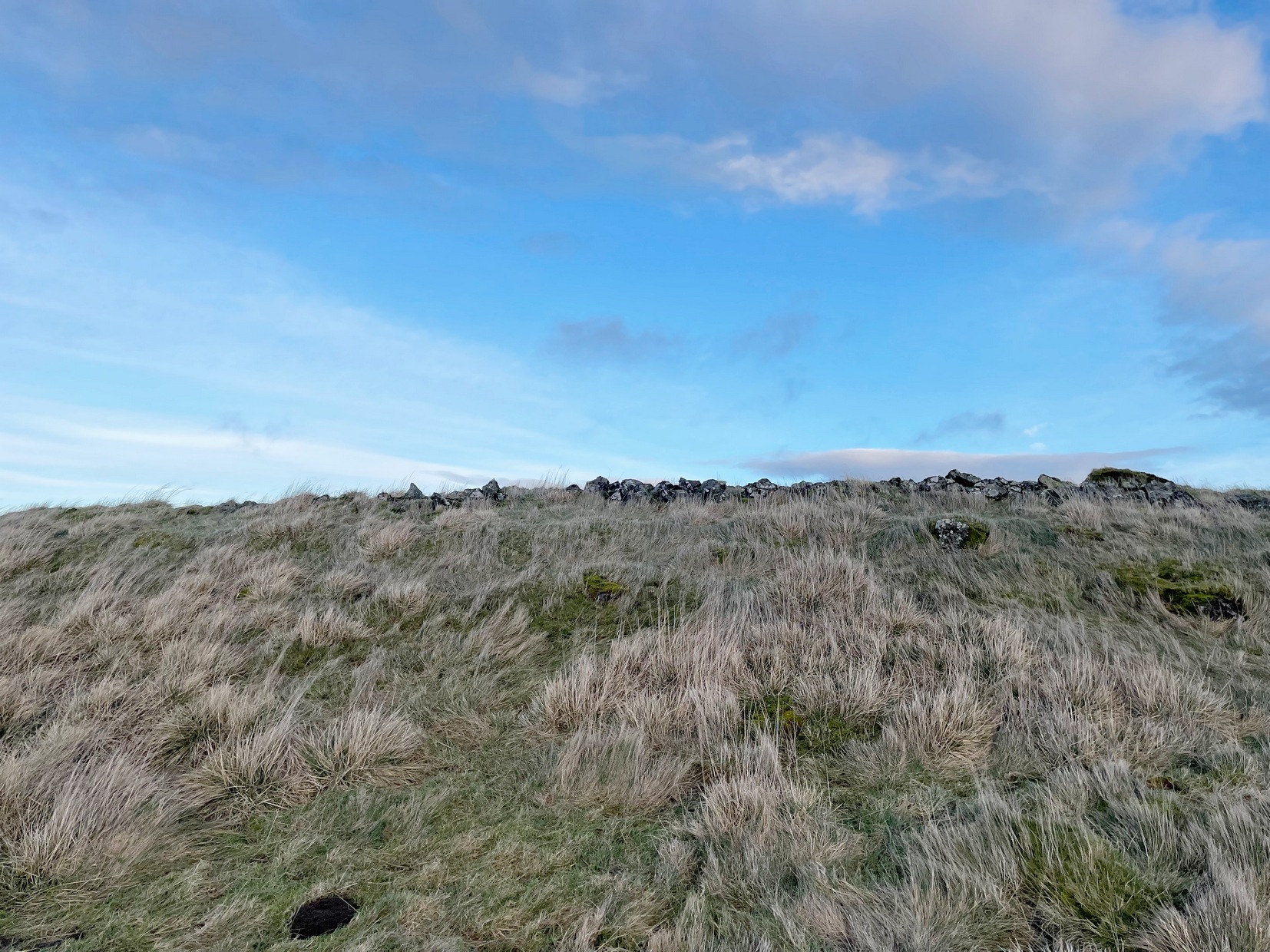
SW wall from rampart
My only visit here was a short one – when some pretty awesome freezing gales were nearly throwing me off the top once I’d got up there! Twas incredible! On my way to the top, nearly there, on its western side, I stopped and looked each side of me as it looked as if a long overgrown line of embankments was running roughly north-south. It seemed very vague and hillforts aren’t my subject, so with the help of the wind throwing me everywhere, I made my my final zoom to the summit, only to be intruded upon again, perhaps 50 feet from the top by another similar-looking embanked ridge—this time with some stones along it and which I was pretty sure were earthworks, or ramparts as they’re known. And so it turned out to be.
Once on top, the views are superb! But I couldn’t really take it in on my short visit here as the freezing wind was truly incredible and I could barely stand upright. And so I briskly followed to the quite notable stone-walled edges of the main prehistoric “enclosure” and walked round the edges as best I could, hoping that at least one or two of the photos I was taking weren’t too blurred.
Views from aboveSW wall & central structure
The interal “settlement” portion of the hillfort is quite large, obviously, allowing for a good number of people to live here (regardless of the wind!). It’s roughly oblong in shape, aligning northwest to southeast, measuring in length a maximum of 78 yards from outer wall to outer wall, with a maximum width of 30 yards (SW to NE). The collapsed walling is still quite extensive and visible above the long grasses almost all the way round the entire structure, averaging one or two yards across. Near the centre of the fortress is a large pile of stones that seemed to have been a structure of some kind, but when i was here I didn’t hang around for too long to inspect it as I was, by now, bloody freezing! It didn’t seem to be a walker’s cairn, but we need another gander to work out what it might have been.
Northern arc of wallingNW line of walling
Curiously this site has had little said about it in archaeo-tomes and to my knowledge, no excavations have happened here. Incredibly, the place wasn’t even recognised as a prehistoric site in official records until the Royal Commission (1963) told of it being “discovered during the survey of marginal lands (1956-58)”! Its very name derives from the word dun, or fort (Watson 1995) and as the place-name writer found out, it was first mentioned in 1542, as Donehill, and many times thereafter in various documents.
Anyhow—check the place out. It’s mightily impressive and the views from the top are excellent. Just avoiding going up there in a freezing gale!
References:
Hogg, A.H.A., British Hill-Forts: An Index, BAR: Oxford 1979.
Royal Commission on the Ancient & Historical Monuments Scotland, Stirlingshire – volume 1, HMSO: Edinburgh 1963.
Watson, Angus, The Ochils: Placenames, History, Tradition, PKDC: Perth 1995.
Acknowledgements:Huge thanks for use of the Ordnance Survey map in this site profile, reproduced with the kind permission of the National Library of Scotland.
Holy Well (destroyed): OS Grid Reference – NT 2611 7600
Also Known as:
Bonnington Mineral Well
Archaeology & History
Site shown on 1862 map
If we’d have lived 200 years ago and walked several miles downstream from St Bernard’s Well on the Water of Leith, we would have eventually come across this little-known sacred site, sadly destroyed in the 19th century. It was shown on the earliest OS-map on the south-side of the river, enclosed in a small square building with what looks like two entrances, and what appears to be a covering of the spring on the southeast side. Marked as a chalybeate, or iron-bearing well, this would have obviously have had repute amongst local people and would have worked as a tonic or pick-me-up, aswell as fortifying the blood and a having a host of other benefits.
The Ordnance Survey lads wrote short notes about St. Cuthbert’s Well in the Name Book of 1852-53, where they told:
“A Well Situated at Bonnington. Supposed to have been dedicated to St Cuthbert; about 34 years ago the proprietor repaired the well and at the same time erected a house over it, and fitted it up for Visitors who are charged one penny for a drink. The Water of the well has been analysed by Professor Jameson and Doctor Turner and it was found to Contain Salts of Iron; Soda, magnesia and Lime, also Iodine under the form of Hydrisdate of Potash.”
About the same time as Jameson & Turner’s analysis of St. Cuthbert’s waters, one Dr Edward Schweitzer (1845) wrote one of the most detailed chemical essays on wells, ever!—using Bonnington’s holy well as his primary focus. A near-thirty-page essay found that, along with an excess of iron, the medicinal aspects of the waters were due to the following compounds found, per grains, in each pint of water:
Sulphate of Potassa — 2.46554 gr
Sulphate of Soda — 1.51227 gr
Sulphate of Lime — 6.28816 gr
Iodide of Sodium — 0.00728 gr
Bromide of Sodium — 0.07886 gr
Chloride of Ammonium — 9.49939 gr
Chloride of Sodium — 3.82963 gr
Chloride of Magnesium — 3.12017 gr
Nitrate of Soda — 2.02154 gr
Carbonate of Magnesia — 1.70443 gr
Proto-Carbonate of Iron — 0.05807 gr
Proto-Carbonate of Manganese — 0.01535 gr
Ammonia (united to organic matter) — 0.42285 gr
Alumina — 0.02245 gr
Silica — 0.18651 gr
In 1837, a Mr Robert Fergusson was known to be “the keeper of the Mineral Well, Bonnington,” but much of its traditions and history have fallen outside of memory. The site was soon to become another mid-Victorian ‘Spa Well’, where local people would have to pay for water they had always used as Nature intended. In truth, the waters and its well-house were to become a place where the rich Industrialists could heal their infirm mind-bodies, hoping that the destitution they lacked emotionally and spiritually would be washed away in the sacred waters. But it didn’t last long! What little is known about it historically was best described in John Russel’s (1933) essay on Bonnington in the Old Edinburgh Club journal. He wrote:
“Just where the Bonnington mill lade joins the Water of Leith once flowed St. Cuthbert’s Well, an ancient spring named after the patron saint of the once extensive parish of St. Cuthbert’s, and like the now forgotten mineral well of St. Leonard’s near Powderhall, a relic of a superstitious age. As to when this well was so designated history is silent but it was probably before 1606, when the Leith portions of Bonnington, Pilrig and Warriston were, by the Scots Parliament, included in the Parish of North Leith…
“In May, 1750 St. Cuthbert’s Well was found to be possessed of medicinal properties. The Scots Magazine of that year refers to many persons frequenting it. The Well formed part of a building which included a pump room and a reading room. From advertisements in the periodicals of 1819 we learn that it was open from 6 o’clock in the morning and that newspapers were to be found on the table all day. The tenant also issued handbills headed “St. Cuthbert’s Mineral Well, Bonnington”, giving a chemical analysis of the water and a list of the ailments for which it had been found beneficial. The Well disappeared with the re-construction of Haig’s Distillery in 1857. It now lies beneath the buildings immediately west of the chimney stack of Messrs John Inglis and Sons.”
St. Cuthbert’s feast day was March 20 (Spring Equinox) and September 4.
A half-mile southwest of here could once be seen the waters of St. Leonard’s Well, which Ruth & Frank Morris (1982) erroneously thought to have been this Well of St. Cuthbert.
The exact location of this site seems privy to a select few and has remained that way since its existence appeared in print in the 19th century. It was first mentioned by Arthur Mitchell (1874) following a holiday that he’d had in the area in the early 1870s. He’d visited a petroglyph at Laggan with a Mr David Ross and when he returned home received a letter from him that told how,
“he had heard from Mr M’Bain of Auchterblair of two huge granite boulders, situated on a shelving rock over an abyss on the Loch Avon side of Cairngorm, with hand-made cups on them about a foot wide and correspondingly deep.”
They were subsequently visited by Thomas Wise (1884) a few years later, who told how these huge granite boulders were,
“20 feet in height,” upon which “there are four basins, 1 foot, or 1 foot and a-half long, and 6 inches wide at the top, rounding off to 1 inch in the bottom.”
Initially Mr Mitchell (1874) was cautious in associating these carved basins with cup-marked stones—and indeed, we concur with this—but seemed to have changed his opinion when he wrote about them a few years later (Mitchell 1881). But it’s the folklore attached to this site that intrigued him – and myself…
Folklore
The traditions attached to this site will be recognised by all students of animism and folklore. Arthur Mitchell (1874) was informed how the carved bowls in the stone helped infertile women and how “sitting on (them) is said to be efficacious in cases of barrenness.” Their importance was highlighted in the fact that there had been “pilgrimages to them undertaken within the memory of people still living.”
This was affirmed by Thomas Wise (1884) who told that,
“They are supposed to be efficacious in barrenness, and people still living remember pilgrims coming to sit upon them for some time, that they might obtain what they wished. A visit to them was by no means an easy task, as the ascent was difficult, and to sit on them required a steady head, as they are on the brink of a rock overhanging a precipice. These basins are the “woman’s stone” mentioned by Tennant. They are supposed to be the resting place or throne of a certain fairy queen; but however efficacious they may have been, they have lost much of their celebrity; and as the shepherd, who acted as guide to the pilgrims, is dead, and has left no successor, they are now rarely visited.”
Does anyone know the whereabouts of this heathen magickal site? If you happen to find it, see if you can get a good photo or two and let us know on our Facebook group.
Cup-and-Ring Stone (lost): OS Grid Reference – NT 482 214
Also Known as:
Blackcastle Hill
Getting Here
Archaeology & History
Despite there being a number of references to this carving, it would seem to have been lost. First described by James Elliot (1967) in the Discovery & Excavation journal , albeit briefly, he told that,
“A cup-marked stone which was found on this farm several years ago, has been recently identified as a “cup within a cup” type. (It was) retained by finder.”
But there was some initial confusion about its general whereabouts when Ron Morris (1967) gave a brief note of what seemed to be an additional carving in the same edition of the 1967 journal, telling us that at nearly Blackcastle Hill there existed the following:
“Small gritstone boulder, truncated-cone-shaped, having on its top surface a “cup-and-ring”, composed of a “saucer” 4½in diameter, within its centre a much deeper and clearly defined “cup”, 2in diameter. Depth 1¼in. Now removed for safety by J. W. Elliot to Whinfield Sawmill yard, Whinfield Road, Selkirk.”
As it turned out, both Elliot and Morris’s separate entries were talking about the same stone. Morris subsequently clarified this when he came to describe the petroglyph in his survey of Southern Scotland. (1981) He reported then that the carving was “beside the house’s porch in the sawmill’s yard” — but it hasn’t been seen since. Does anyone know what’s become of it, or where it might be? If you happen to find it, see if you can get a good photo or two and let us know on our Facebook group.
References:
Elliot, James W., “Synton-Mossend, near Ashkirk: Cup-Marked Stone,” in Discovery & Excavation, Scotland, 1967.
Morris, Ronald W.B., “Blackcastle Hill: Cup Marks,” in Discovery & Excavation, Scotland, 1967.
Morris, Ronald W.B., “The Cup-and-Ring and Similar Early Sculptures of Scotland; Part 2 – The Rest of Scotland except Kintyre,” in Transactions of the Ancient Monuments Society, volume 16, 1969.
Morris, Ronald W.B., The Prehistoric Rock Art of Southern Scotland, BAR: Oxford 1981.
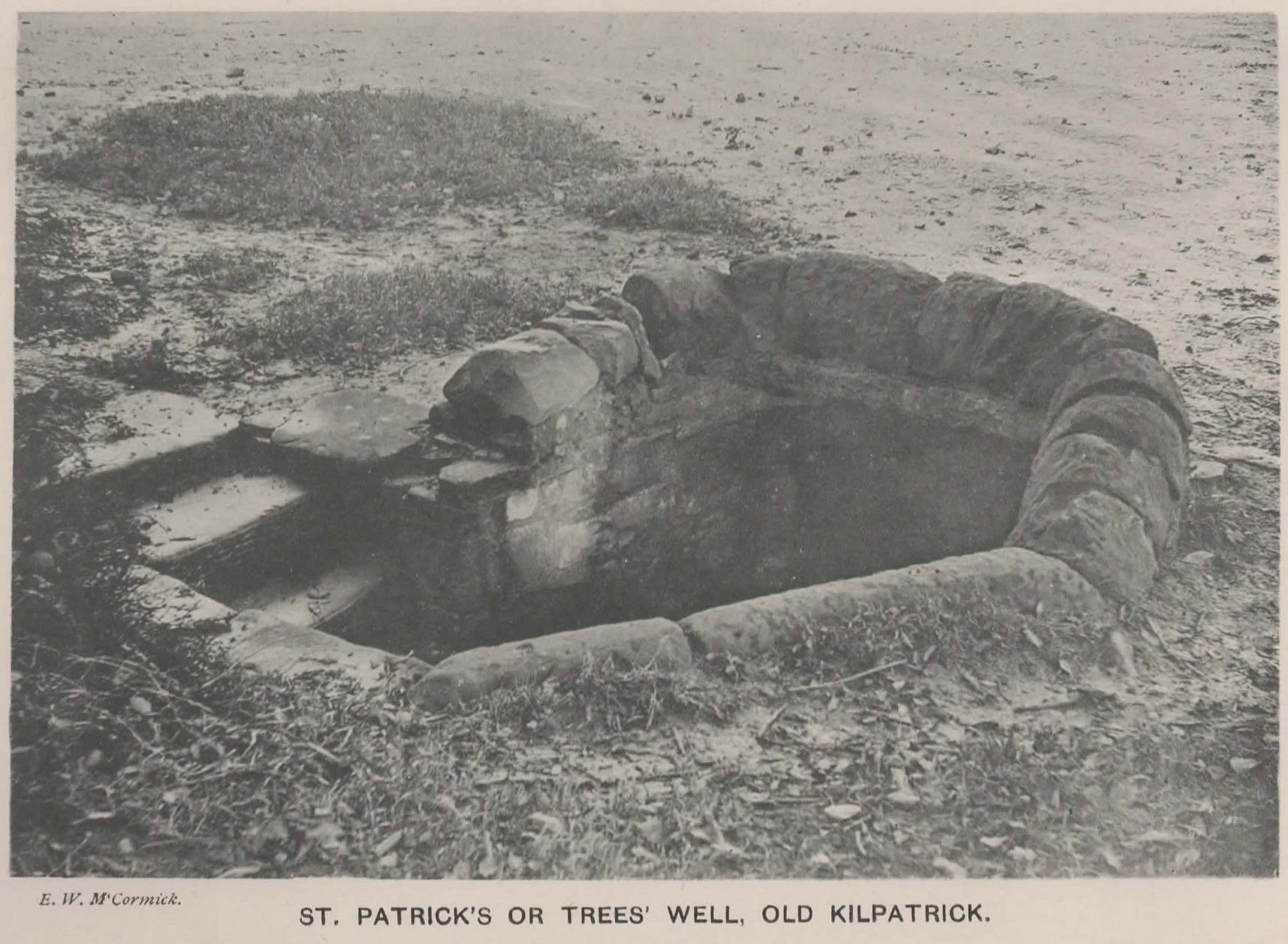
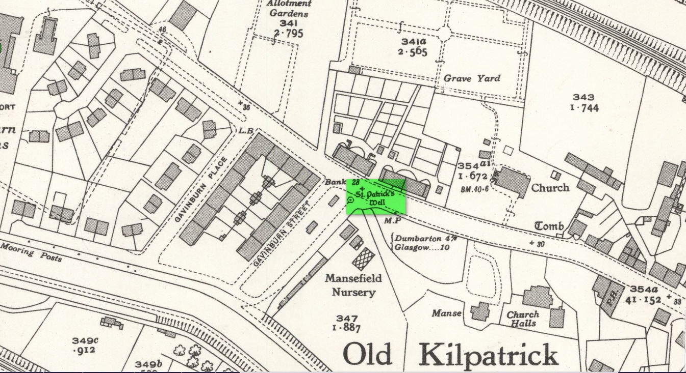
Holy Well (destroyed): OS Grid Reference – NS 4631 7307
Also Known as:
Trees’ Well
Archaeology & History
Photo of the Well in 1893
Sadly there are no longer any remains of this holy well which was found, “beside the church dedicated to St Patrick — which was said to be built on soil brought from Ireland in honor of its patron,” wrote John Bruce in 1893. He told that its waters had “been used until lately from time immemorial by the villagers, but now has been found unfit for use and consequently ordered to be closed up.” Although its waters were used for baptisms, he made no mention of any medicinal repute, which it surely would have possessed.
Site of well on 1939 map
The original position of the well, according to Mr Bruce, was “adjoining the church” but, according to the Ordnance Survey lads, when they came here in 1963 they located a drinking fountain on the other side of the road about 80 yards to the west and designated that as being St Patrick’s Well. The place had earlier been given a wooden sign saying “St Partrick’s Well.” Local tradition attributes St. Patrick as originally coming from this village, whose saint’s day is March 17.
The place was also known as Trees’Well, suggestive, perhaps, of a local person, although I can find no reference as to who or what that might have been.
References:
Bruce, John, The History of the Parish of West or Old Kilpatrick, John Smith: Glasgow 1893.
Acknowledgements:Huge thanks for use of the Ordnance Survey map in this site profile, reproduced with the kind permission of the National Library of Scotland.