Best approached from Ratho village, head up Main Street towards Bonnington Mains. Shortly after the last road in the village (Halicroft Park, on the right) a small line of trees appears on the left and about 250 yards on a footpath takes you therein. Follow this for 250 yards (it runs parallel to the road) and the path then slopes uphill alongside the field. Go all the way to the top (roughly 500 yards) where the small copse of trees crowns the summit. On the ground there are a number of both small and medium-sized flat earthfast stones. You need to walk to the one at the end, just where the hill begins to slope back down. You’ll find it!
Archaeology & History
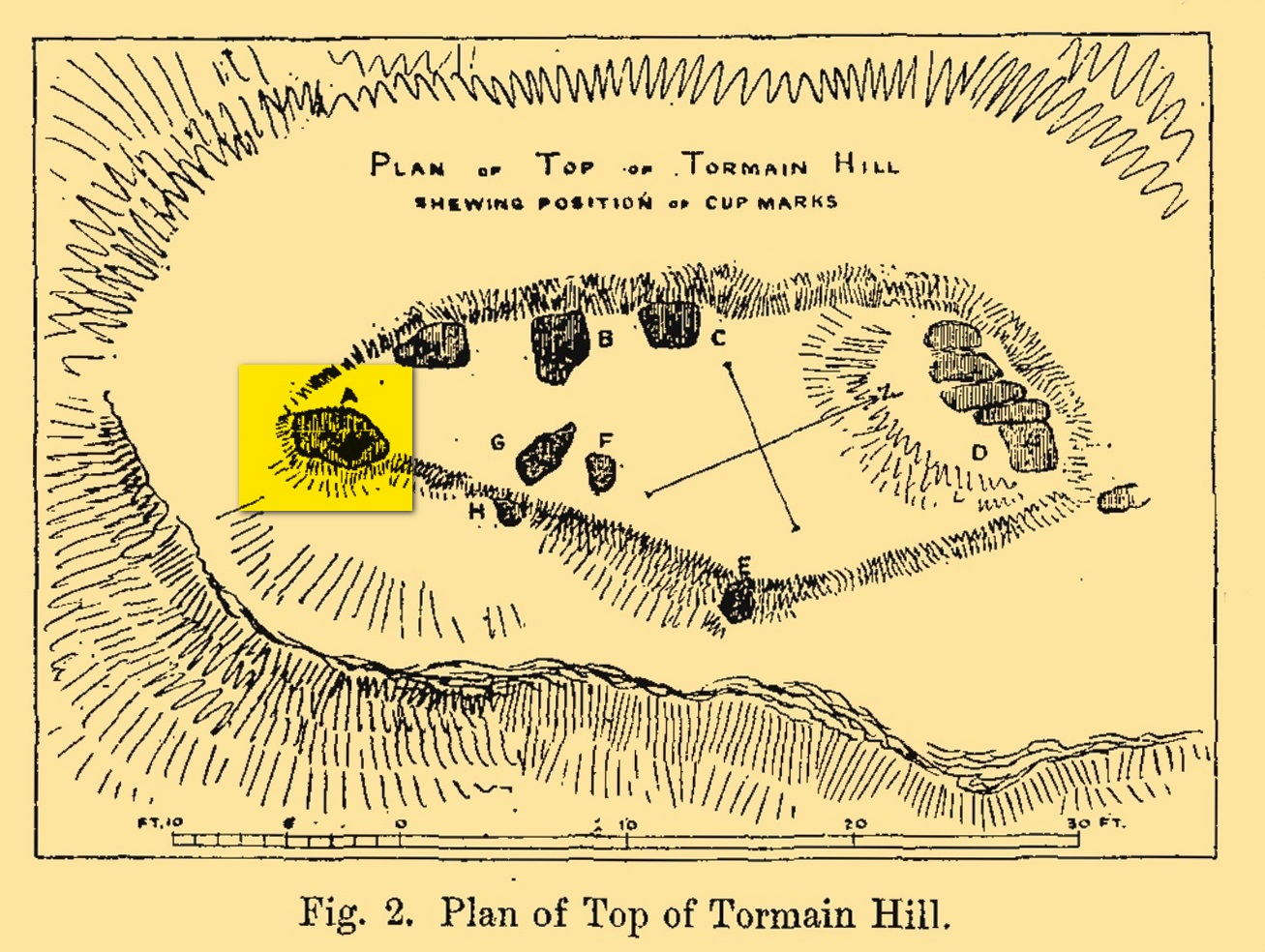
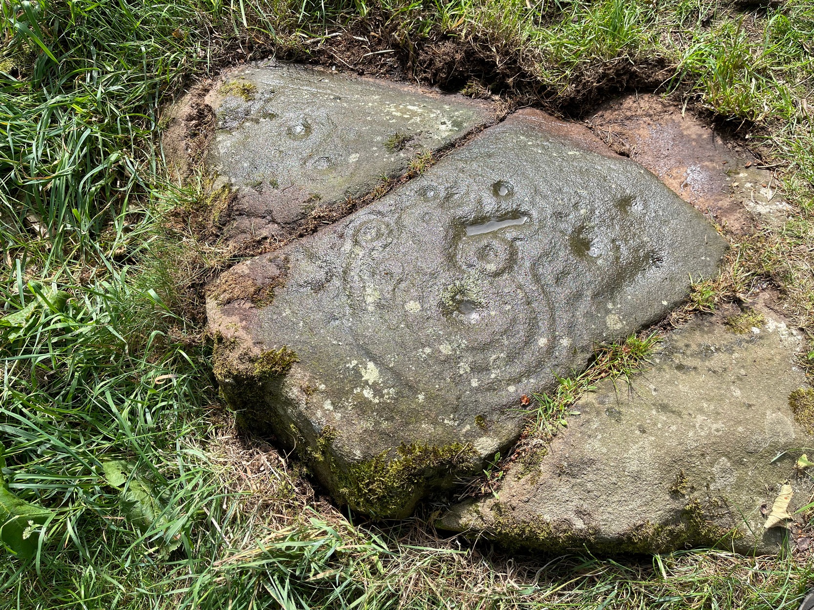
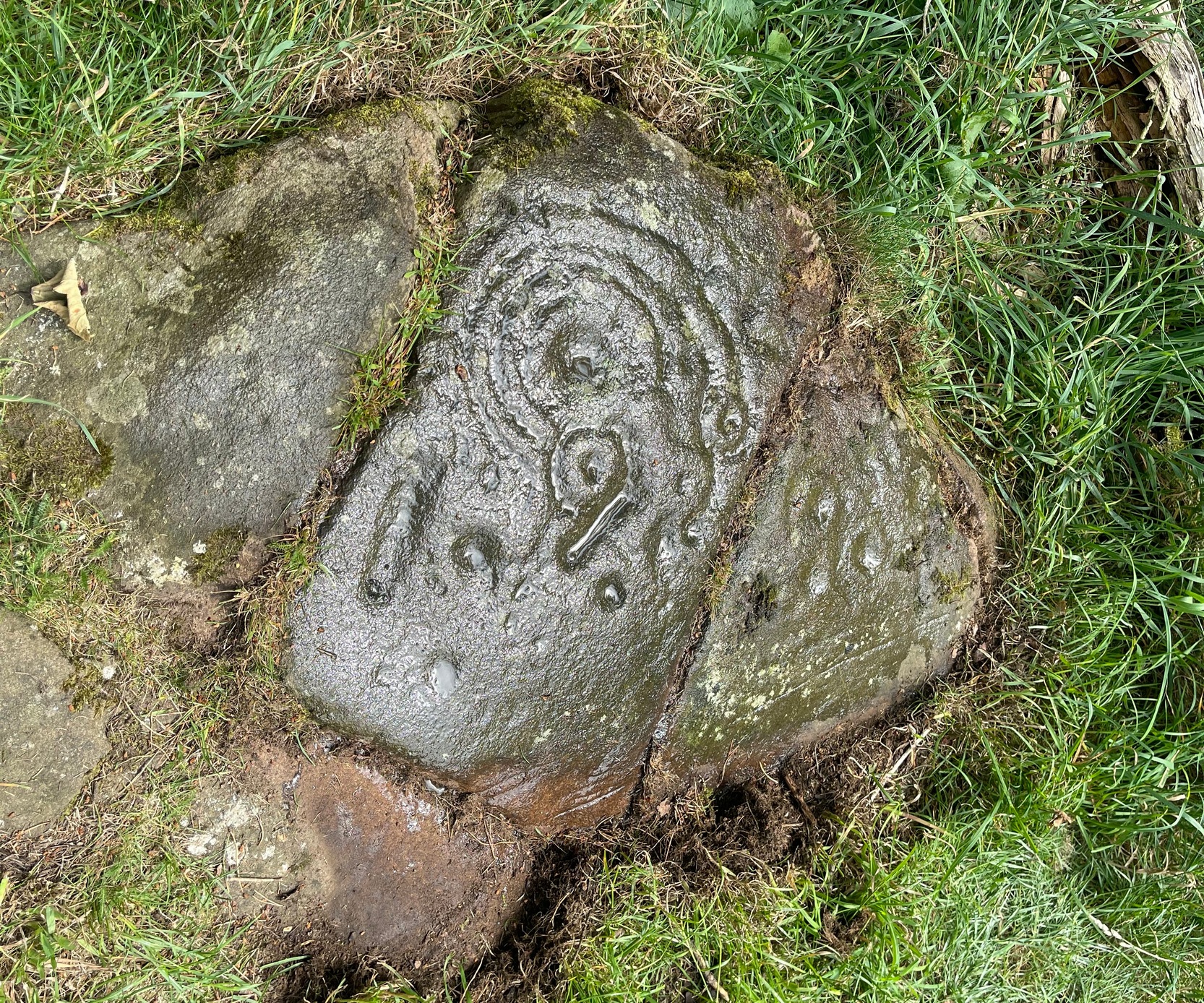
Tormain Hill, or the hill of stones (Harris 1996), has an interesting cluster of petroglyphs on its top, with this one in particular being the most impressive. It’s the southernmost stone in what’s been designated as a cluster of eight carvings—although we need to be slightly sceptical of one or two of them. Not this one though!
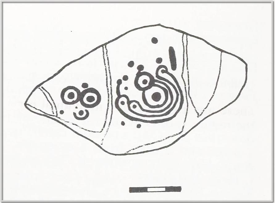
Regarded by Ron Morris (1981) as being “one of the best cup-and-ring designs in Scotland”, it was first mentioned by John Smith (1874) who visited the site with the local farmer James Melvin, who’d discovered the carving some years earlier. Initially he only noticed cup-markings, but when he visited the place with the pioneering rock art researcher Sir James Simpson, upon “removing the shallow soil or turf from the rock on the summit of Tormain Hill” this impressive multiple-ringed design came to light: “one cup (and) four concentric circles .”
A few years later another rock art pioneer, J. Romilly Allen (1882) visited Tormain and found quite a bit more upon this hill. This particular carving, he told,
Allen’s 1882 sketchTormain ‘A’ site (Allen 1882)
“is much the finest and most remarkable in every way. It is the most southerly of the whole group, and is a piece of natural rock projecting from the side of the hill about 9 inches above the turf, and measures 4 feet 3 inches long by 2 feet 3 inches wide. Its upper surface is flat, of oval shape, and slopes slightly towards the hill. It is intersected by two parallel cracks of natural formation. The sculptures consist of twenty cups varying in diameter from three quarters of an inch to 2 inches in diameter. Seven of the cups are surrounded by a single ring, and one by four concentric circles. These latter are not complete, but form loops round terminal cups. Three of the cups with single rings are arranged in the form of a triangle. In addition to the cups and rings are two long grooves, one cutting off the corner of the stone, and the other parallel to one of the natural cracks.”
Beckensall’s 1986 version
More then forty years later the Royal Commission (1929) dudes visited the Tormain stones. It had become so overgrown by then that only two of the eight carved stones were visible: “but a search beneath the turf revealed the other sculpturings,” they told. It would seem that they chose a bit of a grey day when they came here as they told how the carving appeared “so much worn that the concentric rings are, in particular, difficult to follow.” So they did a rubbing of the stone—a common practice of rock art students over the last century or two. In doing so they were able to discern the following:
“The boulder is fractured in two places by natural agencies, but it shows traces of twenty cup-marks, varying from little more than half-an-inch to fully two inches in diameter, and there are two separate gutters. Seven at least of the cups are surrounded by single rings, and in two instances the rings are connected by shallow gutters to simple cup-marks. The largest cup-mark on the stone is encircled by one complete ring with three additional concentric arcs linking up four of the other rings. Another group consists of three cups, each surrounded by a ring, which are closely set in the form of a triangle, with three other smaller cup-marks in close proximity.”
Impressive stuff! In more recent times the site has gained the attention of fellow rock art explorers like Kaledon Naddair, Stan Beckensall and others—but we’re still none the wiser what it means!
Its position in the landscape was probably an important element. Pinus sylvestris (the ley-hunter’s favourite tree) grows spaciously, as it is wont, atop of the hill and, in bygone centuries, would have been much more prevalent before farming enveloped the land hereabouts. It was likely clear of trees on top of Tormain when the stone was carved, giving uninterrupted 360° views of the hills, high and low, as far as the eye can see. The legendary prehistoric Cairnpapple Hill stood out due west from the carving and other notable hilltops in the Pentlands would have had mythic relevance. Sadly, all oral tradition has long long faded and so whatever narratives that were told here have long ago been lost. It strikes me as a tribal gathering place: a moot hill perhaps. The bullaun stone adjacent to this fine carving would be a receptacle for paints, herbs, elixirs to be macerated and used by the people….
Check it out. Have a feel of the place. But spend a few hours here and listen to the wind…
Beckensall, Stan, Rock Carvings of Northern Britain, Shire: Princess Risborough 1986.
Beckensall, Stan, British Prehistoric Rock Art, Tempus: Stroud 1999.
Feachem, Richard, Guide to Prehistoric Scotland, Batsford 1977.
Hadingham Evan, Ancient Carvings in Britain: A Mystery, Garnstone: London 1974.
Harris, Stuart, The Place-Names of Edinburgh: Their Origins and History, Gordon Wright: Edinburgh 1996.
MacLean, Adam, The Standing Stones of the Lothians, Megalithic Research Publications: Edinburgh 1977.
Morris, Ronald W.B., “The Cup-and-Ring and Similar Early Sculptures of Scotland; Part 2 – The Rest of Scotland except Kintyre,” in Transactions of the Ancient Monuments Society, volume 16, 1969.
Morris, Ronald W.B., The Prehistoric Rock Art of Southern Scotland, BAR: Oxford 1981.
Royal Commission Ancient & Historical Monuments of Scotland, Inventory of Monuments and Constructions in the Counties of Midlothian and West Lothian, HMSO: Edinburgh 1929.
Found just a few strides away from the most impressive cup-and-ring stone at Tormain, is this quite un-impressive example and can easily be ignored. This simple cup-marked stone, first mentioned in Romilly Allen’s (1882) survey as “Stone B”,
“…lies 10 feet 3 inches to the north of stone A, and measures 4 feet by 2 feet 3 inches. It has a single cup cut on it.”
Tormain 2 “carving”Tormain 2 “carving”
Despite this being included in archaeological surveys as prehistoric, I’m unsure regarding the archaic authenticity of this single cup-mark and wonder whether it was just the result of idle dabblings by one of the quarrymen here in the 19th century. The lack of erosion leads me to suspect this. It has the appearance of cup-marks that have been carved by students at several different places in Britain (South Yorkshire, West Yorkshire, Perthshire, Renfrewshire, etc) over the last forty years. I’m quite happy to be wrong though! When the Royal Commission (1929) survey mentioned “a single cup on one boulder,” this may have been the one they were referring to.
Royal Commission Ancient & Historical Monuments of Scotland, Inventory of Monuments and Constructions in the Counties of Midlothian and West Lothian, HMSO: Edinburgh 1929.
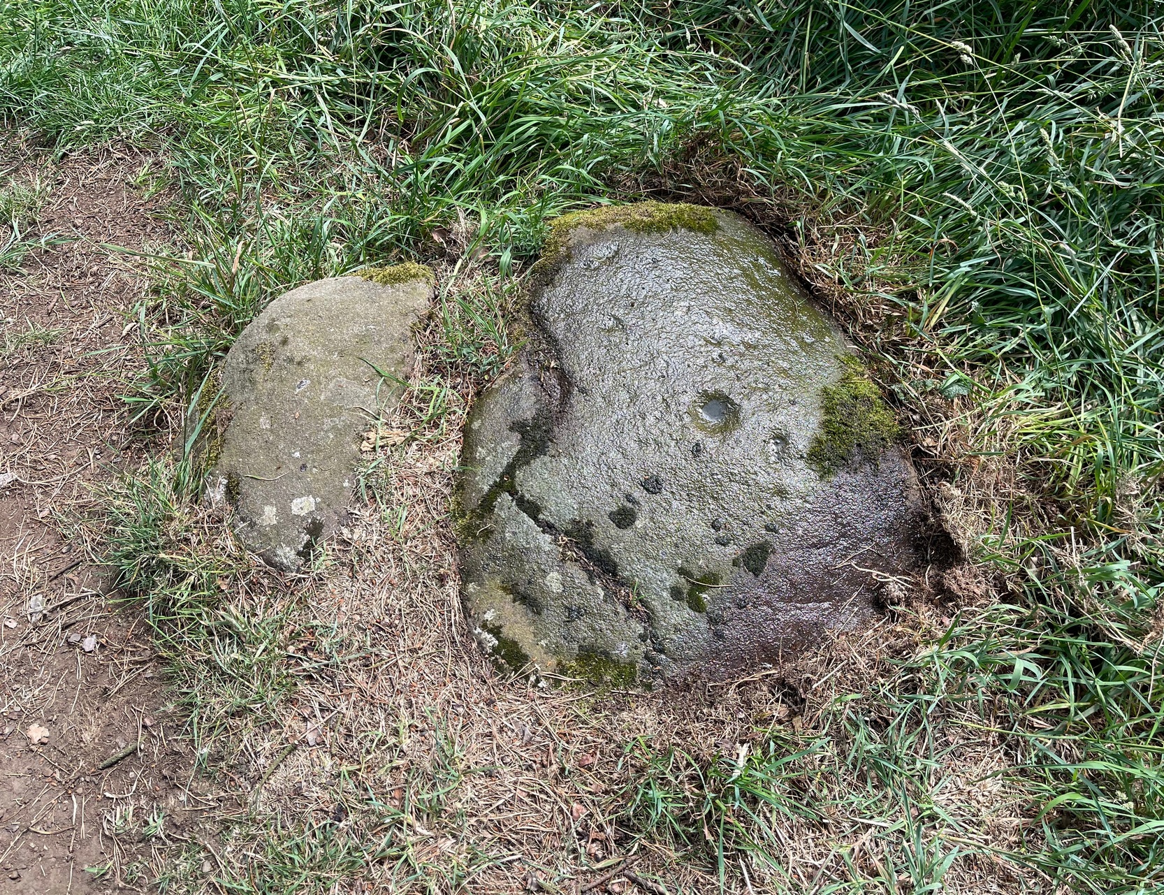
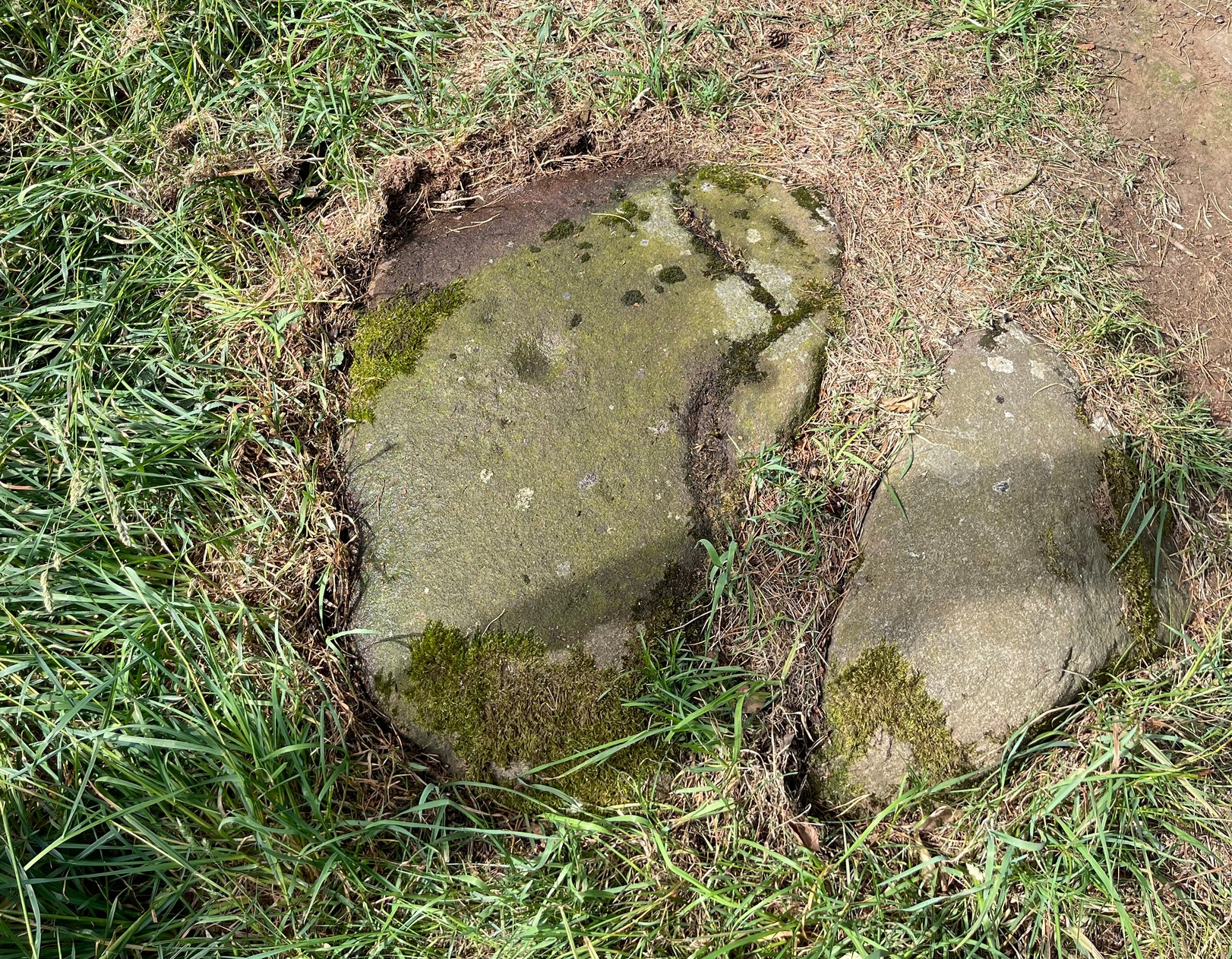
From the Port Appin ferry onto the northern tip of the island, go along the B8045 road for literally 3.5km (2.17 miles) and, shortly after passing Achuaran, a single small white house is on your right. Just yards before here is a small raised rocky knoll. …Or from the Achnacroish ferry, up the road for nearly a mile, then turn right along the B8045 road to Clachan. A half-mile past the hamlet, go past the old School House, then past Mountain View cottage, and the next small white house on the left has a rocky knoll just past it. Just over the wall from the road, a sign points out the legendary Chair that you’re seeking!
Archaeology & History
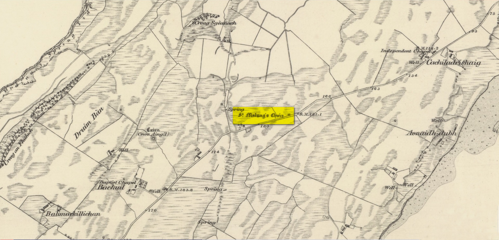
Site shown on 1875 map
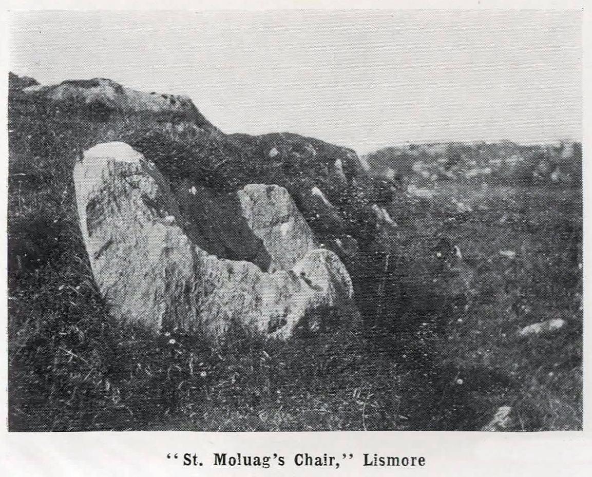
St Moluag, a contemporary of the renowned St Columba, was a 6th century Irish saint who came to reside on Lismore—“the sacred isle of the western Picts”—and here taught the early christian doctrines, fused with indigenous animistic traditions. He used sites of Nature as places of reflection and meditation and this chair-shaped boulder came to be a place renowned as one of his ritual sites, not far from his church. It was described in Frank Knight’s (1933) huge work as possessing healing properties:
“To sit in it used to be considered a sovereign remedy for rheumatism.”
The site was highlighted on the earliest Ordnance Survey map of the island and its lore was remembered by local people of the time. The chair had wider ‘arms’ until the beginning of the 20th century when in widening the road, they were accidentally broken off by one of the workmen.
References:
Knight, G.A. Frank, Archaeological Light on the Early Christianizing of Scotland – volume 1, James Clark: London 1933.
Acknowledgements:Huge thanks for use of the Ordnance Survey map in this site profile, reproduced with the kind permission of the National Library of Scotland.
On the west-side of the River Spey from Fochabers, follow the road-signs taking you south on the B9015, and near Inchberry is a tiny road on your right (careful not to miss it). Go along here to the end of the long straight road and turn right, down the track. When you reach the trees, bear left along the track to St Mary’s, Orton, marked “Private road”. 🙂 Parking is limited to one car only but very quiet.
Archaeology & History
St Mary’s Well, Inchberry (21st Century Pict)
Set in a stunning location next to the river Spey with a magnificent view of Ben Aigan to the south, St Mary’s Holy Well and Pool is easy to find behind the Chapel / Mausoleum wall, dedicated to the Duff Family. There is a small stone basin in the wall which may have been the Chapel font. At the time of my visit the weather has been dry and sunny for some time. The pool below the iron grate has been recently cleared of leaves before my visit, with no standing water but the stones on the bottom of the pool looked damp. And with the cemetery above and behind the wall, perhaps it was for the better.
It was clear and running, said J.F.S. Gordon (1880) at the end of the 1700s, but when he came to write about it the flow “has ceased for many years, and is now only a feeble, filthy, stagnant Driblet for the use of cattle.” Pilgrimages were made here on the first Sunday in May, and water collected from the site was kept for a year, in return for an offering (usually a stone or other inanimate object) that enabled the magickal spirit of the well to enact cures.
Folklore
A site described by Watson (1868) as being “long held in superstitious reverence”, the well was said to cure whooping cough, eye problems and joint conditions. It had thoroughly un-christian shennanigans practised here by local folk, much to the consternation of the usual culprits! Visited extensively by people from far and wide, Mr & Mrs Morris (1981) told,
(21st Century Pict)
“The visits displeased the Kirk and there were various summonses to the Session for “going supersticiously to a Vell at Speyside” and of persons who “kneillit about the chappell and drank the water.” The minister at Ruthven reported that a large number had gone to the chapel well “thrie Saturdays before Lambas and thrie efter called the six silie Saturdayes, and that the conventions wer on the night or before day in the morning.” And “quhairas zierlie about Lambnes, the ignorantes repaired to ane wel at this kirk, called Our Ladie Wel, superstitiouslie, and kneeled about the said kirk, it is reportit that the evil is removed.” This may be the well associated with the White Witch, Dame Aliset, who cured a fairy child with simples and the well water.”
References:
Bord, Janet, Holy Wells in Britain – A Guide, HOAP: Wymeswold 2008.
Watson, J.& W., Morayshire Described, Russell & Watson: Elgin 1868.
Acknowledgements:Huge thanks for use of the Ordnance Survey map in this site profile, reproduced with the kind permission of the National Library of Scotland.
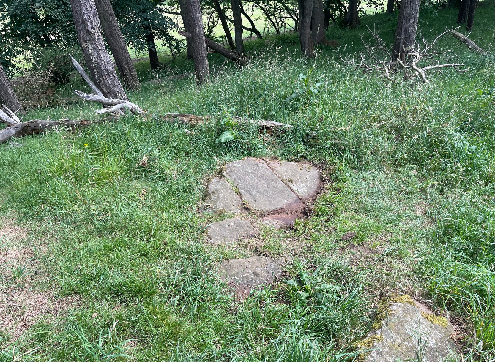
Take the same directions as if you’re visiting the Tormain (1) carving (the best one of the bunch here), but about five yards before reaching it, to your immediate left, just at the edge of where the hill drops down slightly, you’ll see a small flat rock poking out of the ground that may have been cut and quarried at some time in the past. That’s the one!
Archaeology & History
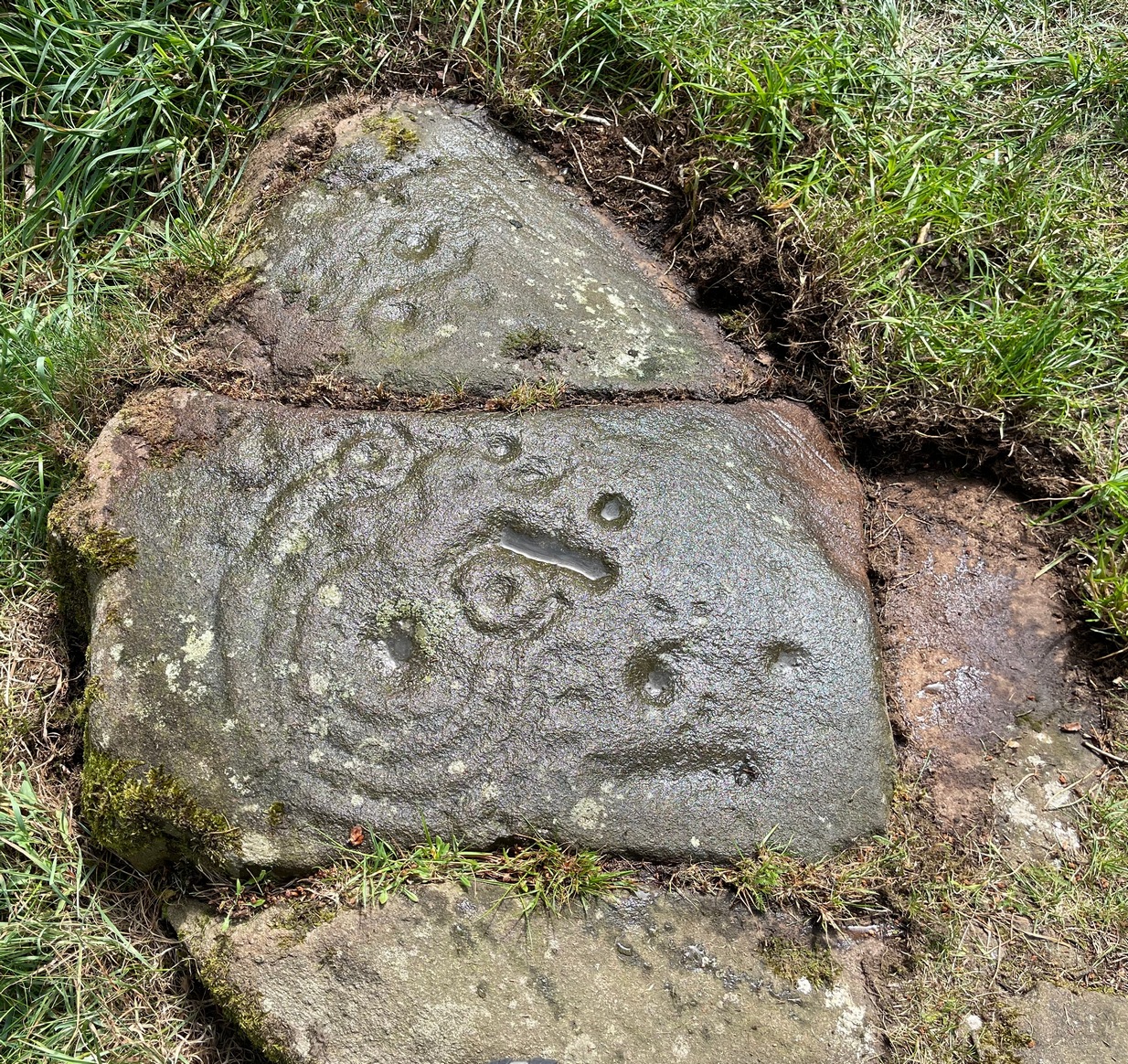
This small compact design looks like a typical cup-marked stone with the usual scatter of cups in no seeming order—until, that is, you walk around it and look at it from different angles, whereupon you’ll notice that a couple of distinct deep carved lines have been cut in a cross formation, with cup-marks at the ends of the crucifix. My view of this is that cup-marks were done first, probably in the standard Bronze Age period, and the ‘cross’ was cut into the stone at a much later date, probably during the early christian era. The depth of the lines which create the ‘cross’ is deep and thin at the bottom, suggesting a metal tool, which seems to have been cut into an natural crack. Visitors here will notice a small drill-hole near the edge of the stone which seems to have been done by local quarrymen, probably in the 19th century.
It was first described in Romilly Allen’s (1882) article on the Tormain stones. He called it ‘Stone E’ and told that it
Location of Tormain 5Cups, lines & cross form
“is situated about half-way between stones A and D, and is furthest to the east. It measures 1 foot 4 inches by 1 foot 9 inches, and projects 1 foot above the turf. Its upper surface is flat, and on it are carved eight cups varying in diameter from 1 to 2½ inches. There are two connecting grooves between three of the cups, forming a rude cross. Another cup has a channel leading over the edge of the stone.”
In November 1927, the Royal Commission dudes visited the carving (and its companions), but they had to roll back the turf to see it clearly. On the stone they saw that “at least nine or ten cup-markings, in some cases with connecting gutters, are still more or less clearly outlined.”
Carving highlighted (Morris ’82)Ron Morris’s old photo
When Ron Morris (1981) visited here, he highlighted the carving in chalk to get a decent impression of the design, as the attached photo here shows. Many traditional cultures ritually paint their carvings at set times of the year, in traditions that go back many centuries—perhaps even millenia. In all probability the same thing was done at some of the British petroglyphs, although there are no remaining traditions. Anyhow, Morris described it succinctly as:
“½m square, ¼m high…on which are: eight cups up to 7cm (3 in) diameter and 4cm (1½ in) deep and some grooves, to of which connect some of the cups to form a well-defined Cross.”
The stone was looked at by the great rock art explorer Kaledon Naddair of Edinburgh, but sadly I’m unable to locate his report and the fine illustrations that always tended to accompany them. If you’re reading this sir, give us your valuable input!
Beckensall, Stan, Rock Carvings of Northern Britain, Shire: Princess Risborough 1986.
Beckensall, Stan, British Prehistoric Rock Art, Tempus: Stroud 1999.
Feachem, Richard, Guide to Prehistoric Scotland, Batsford 1977.
Hadingham Evan, Ancient Carvings in Britain: A Mystery, Garnstone: London 1974.
Morris, Ronald W.B., “The Cup-and-Ring and Similar Early Sculptures of Scotland; Part 2 – The Rest of Scotland except Kintyre,” in Transactions of the Ancient Monuments Society, volume 16, 1969.
Morris, Ronald W.B., The Prehistoric Rock Art of Southern Scotland, BAR: Oxford 1981.
Royal Commission Ancient & Historical Monuments of Scotland, Inventory of Monuments and Constructions in the Counties of Midlothian and West Lothian, HMSO: Edinburgh 1929.
Acknowledgements: Huge thanks to Jan Carrington for use of her photos. 🙂
First mentioned in place-name records from 1409, this seemingly lost sacred well could be found in the south-side of St. Leodegarius’s churchyard. It was filled-in sometime in the 19th century when the ground around it collapsed to some considerable depth, so the hole was covered. Despite this, water kept re-appearing on and off over the decades and, in Bob Morrell’s (1988) holy wells survey, he told that following constant heavy rains in 1987, it was filled in for the last time.
References:
Bailey, Thomas, Annals of Nottinghamshire, Simpkin Marshall: London 1853.
Gover, J.E.B., Mawer, Allen & Stenton, F.M., The Place-Names of Nottinghamshire, Cambridge University Press 1940.
Harte, Jeremy, English Holy Wells – 3 volumes, Heart of Albion press: Wymeswold 2008.
Morrell, Robert, Nottinghamshire Holy Wells and Springs, Nottingham 1988.
Located in the copse known as Godwell’s Grove on the western boundary of Arkesden, there are good grounds for thinking this was a sacred well: not necessarily relating to the christian God, but what A.H. Smith (1956) described simply as, from the old English, “a (heathen) god.” Another site of the same name is found in Wiltshire. In the local survey by Parish (2010), he told that “its name suggests it is a holy well.”
In Reaney’s (1976) survey on English place-names, he looks at a number of places where the element “god” is found and explores the notion of them recording a personal name, Gode. This is evident of course, but he stated that,
“it would indeed be a remarkable coincidence if all these names…were to contain the personal-name Gode, a short form of Godric, Godwine, etc. It in inconceivable that the reference should be to the christian deity… All are situated in areas of early settlement where heathen place-names might be expected and may well contain OE god, ‘a god’.”
There is no longer any trace of the well.
References:
Parish, R.B., Holy Wells and Healing Springs of Essex, Pixyled Press: Nottingham 2010.
Reaney, P.H., The Place-Names of Essex, Cambridge University Press 1935.
Reaney, P.H., The Origin of English Place-Names, RKP: London 1976.
Smith, A.H., English Place-Name Elements – volume 1, Cambridge University Press 1956.
Robin Hood wells are numerous in Yorkshire and Derbyshire, but finding them in this neck o’ the woods is unusual (a Robin Hood’s Farm can be found nearly 14 miles south). The waters here would have had obvious importance for local peasant folk in bygone centuries, perhaps with scatterings of Beltane and Midsummer rites hereby; but it seems that records are silent on such matters. The only reference I can find of this place is in Bracken’s (1860) fascinating work on Sutton Coldfield, where he told that,
“At the extremity of the parish, near Pype, a little field is still called the Bowbearer’s Croft. Tradition says two officers of the chase, bowbearers, had a lodge there; and that their duty was to guide the travellers across the wild country. A very old cottage, that had been well built, was removed from the croft in 1828. In that neighbourhood was a fountain, called Robin Hood’s well, now enclosed within the grounds of Penns, where the natural beauties of the situation have been judiciously displayed and improved by the taste of the late proprietor, Joseph Webster.”
Marshy ground to the east of Pype Hall fed the large pond, which is one contender for the site of this lost well. What has become of it? A search in the local library archives for any old manorial maps, or the field-name maps showing Bowbearer’s would prove truly helpful in relocating this site.
References:
Bracken, L., History of the Forest and Chase of Sutton Coldfield, Simpkin Marshall: London 1860.
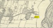
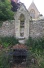
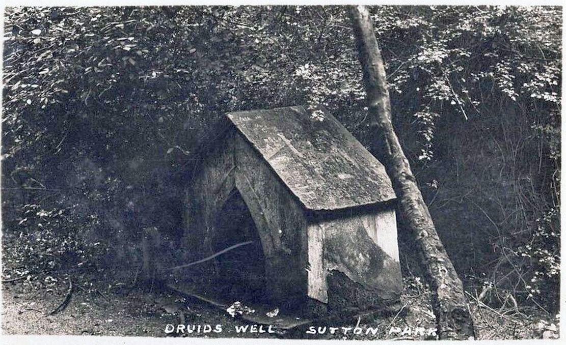
Highlighted on the 1884 Ordnance Survey map of the region and located beyond the far eastern end of Braceridge Lake, this legendary well has seen better days. A small well-house once covered the spring, but all we have left today is little more than a rectangular stone-lined concrete hole-in-the-ground where the waters collect (hopefully some local folk can bring it back to life). But in the 19th century it was well known, much frequented and maintained.
Not much seems to be known about its mythic history, as the traditions surrounding its dual pagan-christian dedication seem to have been forgotten. When the local writer Tom Burgess (1893) came to explore its history, he merely wrote:
“How it came to be called the Druids’ Well is not known, it is scarcely necessary to say that it can have no Druidical connection; it is very probable, however, that it was dedicated to Saint Mary long before the dam of Bracebridge Pool was made by Ralph Bracebridge in the reign of Henry V.”
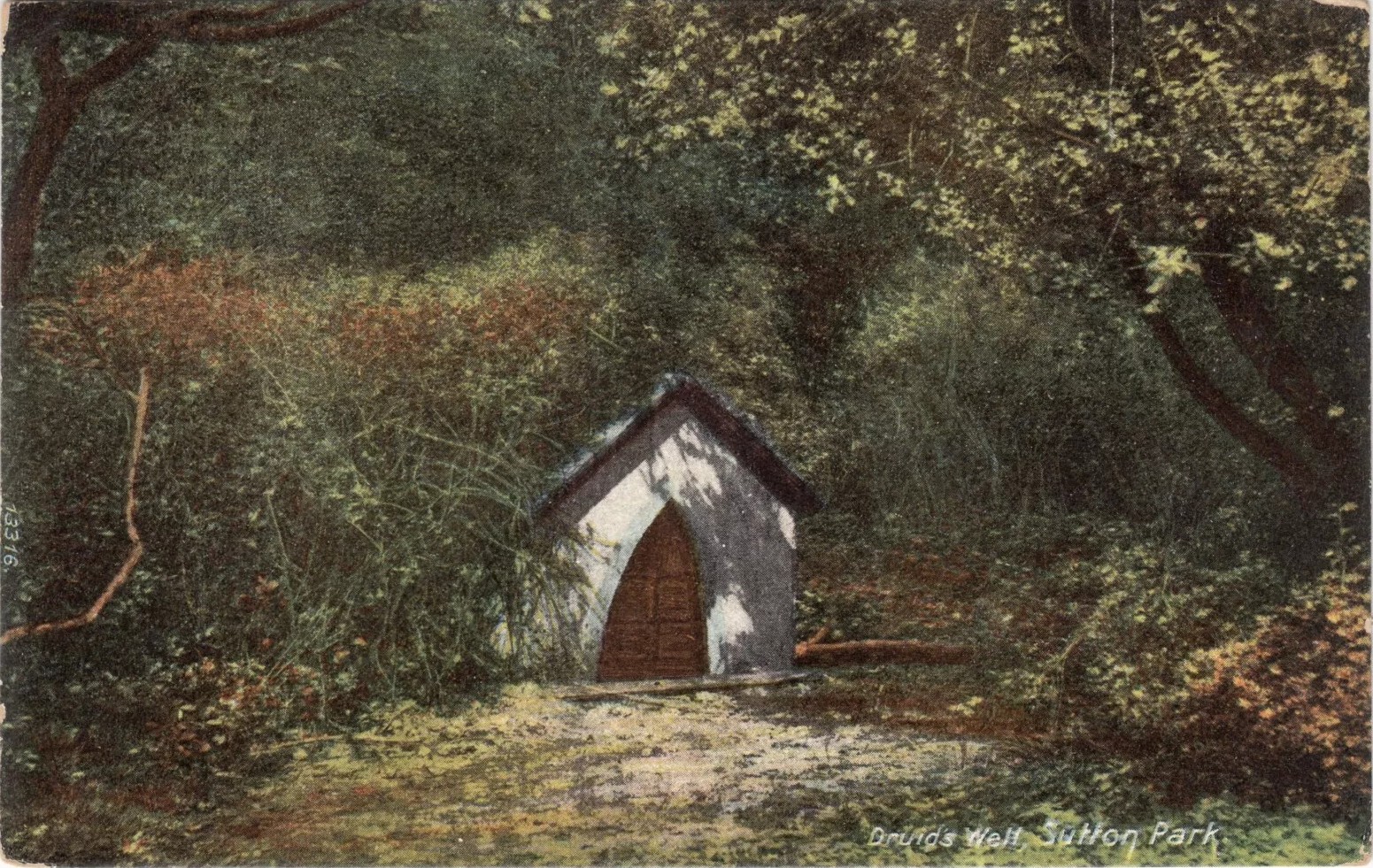
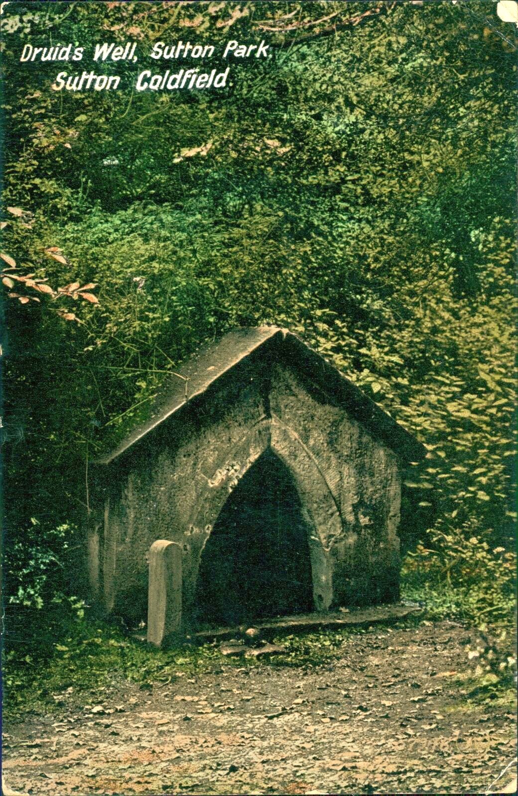
Druids Well in 1917Druid’s Well in 1932
Jeremy Harte (2008) suggested that this well’s druidic association may have come from a local man, William Hutton who, in the middle of the 18th century, “speculated on a druid sanctuary near Sutton Coldfield.” But before Hutton, the 17th century Staffordshire topographer, Robert Plot, suggested that an arch-druid held residence on Barr Beacon, which is less than three miles west of here. This idea was echoed by Midgley (1904) who told that Barr Beacon “is supposed to have been a Druidical shrine.” Just over three miles to the northwest, the Druid’s Heath (a place-name derived, apparently, from an old family) at Aldridge also had its own array of folklore which, perhaps, may have had something to do with this well’s association. When Roy Palmer (1976) wrote about the Druid’s Well in his folklore survey, he told that Sutton Coldfield,
“is said once to have been the seat of the arch-druid of Britain; perhaps this was his well, which was later christianized.”
So much to choose from…
References:
Bord, Janet, Holy Wells in Britain – A Guide, HOAP: Wymeswold 2008.
Bracken, L., History of the Forest and Chase of Sutton Coldfield, Simpkin Marshall: London 1860.
Harte, Jeremy, English Holy Wells – volume 2, Heart of Albion press: Wymeswold 2008.
Midgley, W., A Short History of the Town and Chase of Suton Coldfield, Midland Counties Herald: Birmingham 1904.
Palmer, Roy, The Folklore of Warwickshire, Batsford: London 1976.
Acknowledgements:Huge thanks for use of the Ordnance Survey map in this site profile, reproduced with the kind permission of the National Library of Scotland.
Cup-and-Ring Stone (removed): OS Grid Reference – NT 12364 32627
Also Known as:
Drumelzier Carving
Archaeology & History
Position of stone in cairn
A carving that was located at the edge of a cairn on a knoll on the east-side of the River Tweed, this is an odd design that now lives in Edinburgh’s central museum: odd, inasmuch as the design looks as if it’s a typical cup-and-ring carving, yet none of the cups on this stone were ever hollowed or pecked out, and so the “cups”, so to speak, are actually small rings (if that makes sense!). There are a number of similar unhollowed “cups” on other carvings that are found associated with prehistoric tombs, so perhaps this aspect was something of a burial trend—amongst a very small tribal group, perhaps… It’s an element that was remarked upon in Simpson & Thawley’s (1972) examination of petroglyphs in neolithic tombs that were called “passage grave style” carvings: a sort of dyslexic cup-and-ring design no less! The intriguing thing about this carving is that it’s one in a small cluster of dyslexic cup-and-rings that are found in this part of Scotland—in an area where rock art itself is pretty scarce. Which begs the question: was it a local tribal style? Anyhow…
The carving was first uncovered when J.H. Craw (1930) excavated the aforementioned cairn, finding therein a number of cists. There’s speculation that the petroglyph might originally have been a covering stone for one of the cists, but we don’t know for sure. Craw described the carving as follows:
Craw’s 1930 sketchRon Morris’ 1981 sketch
“The ring-marked slab…measures 3 feet by 2 feet by 6 inches. It lay at the north side of the cairn (highlighted in sketch, PB), outside the encircling ring, but may originally have been the cover of cist No.2. On the upper side are five shallow ring-markings, four being double and one single. The former measure 3 inches to 4 inches in diameter, and the latter 1¾ inch. The figures are thus much smaller than in typical cup-and-ring-marked stones, and the lines are only ¼ inch in width. The only similar markings known to me are on a slab which I found a number of years ago near the site of several former cairns, and forts at Harelawside near Grant’s House, Berwickshire. The stone is now in our Museum.”
The “museum” in question being Edinburgh’s National Museum (I don’t know if it’s in a box somewhere or on public display, which is where it needs to be). If anyone can get a good photo of this carving, please send it to us or add it on on our Facebook group.
Morris, Ronald W.B., “The Cup-and-Ring and Similar Early Sculptures of Scotland; Part 2 – The Rest of Scotland except Kintyre,” in Transactions of the Ancient Monuments Society, volume 16, 1969.
Morris, Ronald W.B., The Prehistoric Rock Art of Southern Scotland, BAR: Oxford 1981.
Ritchie, Graham & Anna, Edinburgh and South-East Scotland, Heinnemann: London 1972.
Royal Commission on the Ancient & Historical Monuments, Scotland, Peeblesshire – volume 1, Aberdeen University Press 1967.
Simpson, D.D.A. & Thawley, J.E., “Single Grave Art in Britain,” in Scottish Archaeological Forum, no.4, 1972.
Acknowledgements:Huge thanks for use of the Ordnance Survey map in this site profile, reproduced with the kind permission of the National Library of Scotland.
 Tormain Hill, or the hill of stones (Harris 1996), has an interesting cluster of petroglyphs on its top, with this one in particular being the most impressive. It’s the southernmost stone in what’s been designated as a cluster of eight carvings—although we need to be slightly sceptical of one or two of them. Not this one though!
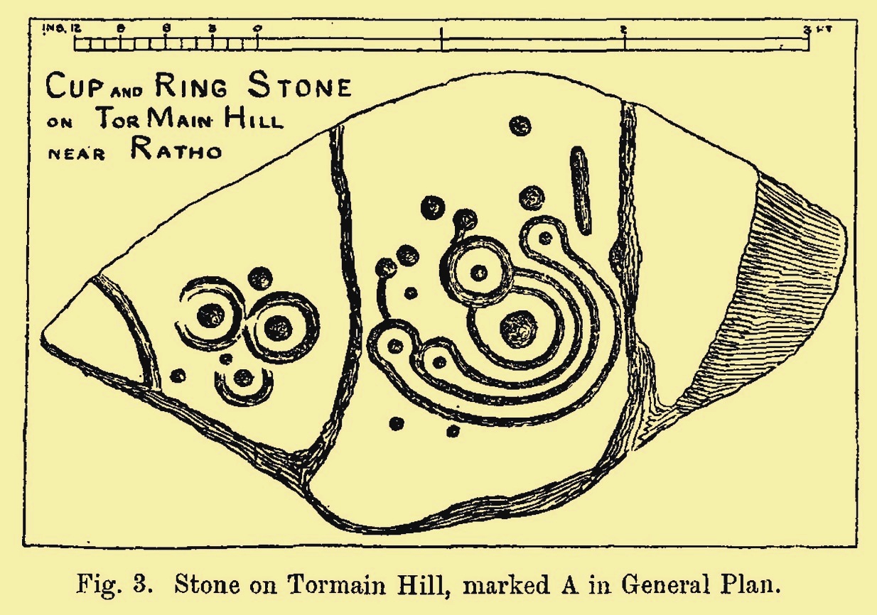
 Its position in the landscape was probably an important element. Pinus sylvestris (the ley-hunter’s favourite tree) grows spaciously, as it is wont, atop of the hill and, in bygone centuries, would have been much more prevalent before farming enveloped the land hereabouts. It was likely clear of trees on top of Tormain when the stone was carved, giving uninterrupted 360° views of the hills, high and low, as far as the eye can see. The legendary prehistoric Cairnpapple Hill stood out due west from the carving and other notable hilltops in the Pentlands would have had mythic relevance. Sadly, all oral tradition has long long faded and so whatever narratives that were told here have long ago been lost. It strikes me as a tribal gathering place: a moot hill perhaps. The bullaun stone adjacent to this fine carving would be a receptacle for paints, herbs, elixirs to be macerated and used by the people….