Holy Well, Barking, Essex

Holy Well (destroyed):  OS Grid Reference – TQ 4421 8484

Archaeology & History

Barely 200 yards to the immediate southeastern edge of the once gigantic hillfort of Uphall Camp, could once be found an old holy well, last recorded it would seem in 1456.  The site was located just yards to the south of the old boundary that separates the parishes of Ilford and Dagenham.  Its location was described in the Victoria County History:

“A mile south of Ilford Bridge the Roding is joined by Loxford Water, a stream rising near Hog Hill, in Dagenham, and known in its upper reaches as Seven Kings Water. In 1456 the lower part of the stream was called Halywellbrooke.”

We also have an account in the Barking Abbey Rental, which told us there was “land in Longland at Halywellbrooke”, as well as “pasture lying at the northern head of Luzias land…near Halywell and…at Loxfordbrigge.” (Harte 2008)  It has long since been destroyed.

References:

  1. Harte, Jeremy, English Holy Wells – volume 2, Heart of Albion Press: Marlborough 2008.
  2. Powell, W.R. (ed.), A Victoria County History of Essex – volume 5, OUP: London 1966.

LinksHoly Well, Barking on The Megalithic Portal

Middleton Moor Carving (484), North Yorkshire

Cup-Marked Stone:  OS Grid Reference – SE 11650 51623

Getting Here

Go over Ilkley Bridge and take your first left, on & over the roundabout, then follow the road as it bends uphill.  Keep going until you reach the fields and moors either side of you, up Hardings Lane, stopping at the bend in the land where it meets a couple of dirt-tracks.  Go up the track onto the moor and follow this right into the moorland (avoiding the path to your right after a few hundred yards) where it follows the edge of the walling again.  After a few hundred yards there’s a gate on your right.  Go thru this and, after 40-50 yards, walk up into the heather.  You’re damn close!

Carving no.484

Archaeology & History

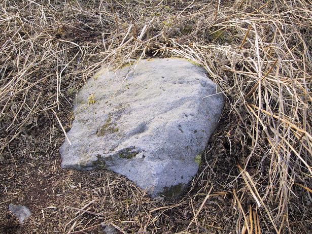
This is another cup-marked stone that’ll only be of interest to the petroglyphic purists amongst you, as it’s another one of those incredibly interesting single cup-marked rocks — this time with an additional single line running from it!  WOWWWW….! The photo here just about does it justice, as in some light conditions you wouldn’t even notice it.  There’s also the possibility that this ‘carving’ was actually Nature’s handiwork.

It was first described by our old mate Stuart Feather in 1965, and was then included in Boughey & Vickerman’s (2003) survey as stone 484, describing it as, “medium-sized, approximately square rock of fairly smooth grit.  One cup with groove leading from it.”

References:

  1. Boughey, Keith & Vickerman, E.A., Prehistoric Rock Art of the West Riding, WYAS: Wakefield 2003.
  2. Feather, Stuart, “Mid-Wharfedale Cup-and-Ring Markings: Nos. 36, 37 and 38, Middleton Moor, Ilkley,” in Cartwright Hall Archaeology Group Bulletin, volume 10, 1965.

ACKNOWLEDGEMENTS: to Richard Stroud for use of his photo

© Paul Bennett, The Northern Antiquarian