Chalkwell Hall, Southend-on-Sea, Essex

Tumulus (destroyed):  OS Grid Reference – TQ 861 862

Archaeology & History

Somewhere beneath the modern housing estate immediately east of Chalkwell Park was once a large prehistoric burial mound.  It was included in Wymer & Brown’s (1995) archaeological gazetteer (albeit at the wrong spot) without comment, but their reference led me to an early description of the place by Philip Benton (1867) whose description gave us the best info we have of the place.  He wrote:

“To the east of the present mansion, at the north-west comer of a field called Fishponds, is a tumulus or mound, probably Celtic.  This was first opened about thirty years ago, when bones, a few coins, and a piece of chain were discovered.  Since which period about eight feet of earth has been removed from the summit, when more bones were found, but as they were not inspected by any one competent to give an opinion, it is impossible to say whether they were those of man or beast.  The mound is still about four feet above the surrounding soil, and would probably repay further search.”

Wymer and Brown listed the site as being an “early Bronze Age” monument.

References:

  1. Benton, Philip, The History of Rochford Hundred – volume 2, Harrington: Rochford 1867.
  2. Wymer, J.J. & Brown, N.R., Excavations at North Shoebury, East Anglian Archaeology: Chelmsford 1995.

© Paul BennettThe Northern Antiquarian

Robin Hood’s Oak, Great Horkesley, Essex

Legendary Tree (lost):  OS Grid Reference –TL 96 28

Archaeology & History

In more than twenty volumes about Robin Hood in the Northern Antiquarian library, no mention can be found of this all-but-forgotten site, first recorded (I think) in September 1637, in the boundary perambulation account of northern Colchester.  In days of olde, folk walked the boundaries annually and so the description given here follows their very footsteps – although the landscape has obviously been altered in places since then.  Because of the length of the entire perambulation their account is rather long, so I’ve cut to the piece relating to our legendary oak tree, which gives a good idea of its location.  We meet up with them at a place called Motts-Bridge, just above a place that is today called Seven Arches Farm (TL 9630 2595):

“…and so over Mott’s-bridge, and so cross the river by Nicholas Ayleward’s howse into the meadowe crossinge over to the lower ende of West-fielde, and from thence to Buttolph’s brooke leavinge the Brooke alwais upon the left-hand, and so along to Thomas Abrige (which is righte against Robin Hood’s oake). And from thence to Black-brooke under Chesterwelle and so along the Rampiers by Horkesley Heathe to the brooke that is under Langham-park-corner…”

P.H. Reaney (1935) proposes that the ‘Rampiers’ in this account is the Iron Age hillfort of Pitchbury Ramparts.

The description of its whereabouts isn’t too clear, but in a subsequent and much longer perambulation account from August 1671, some extra topographical features are mentioned.  Starting not far from Mott’s Bridge, down Shett’s Hill to Newbridge,

“and then into the Fields in the occupation of Matth. Ayleward…through a gate a little above the Bridg: and soe along to Matth. Ayleward’s Yard, crosse the River into Matth. Ayleward’s Meadowe, and crosse that Meadowe into the lower part of Westfields, neare to which is a Foote-bridge cross the river, which is called Mott’s-bridge.  And soe along through West-fields to a Gate in a lane at or neere the north ende of a Meadow of one Mrs —, now in Samuel Duglet’s occupation, which lane parts West-fields from Bergholt, as the Parsons of each Parish, whoe were both present, affirmed; and, upon a Tree standing neere to which Gate is set a crosse.  And from thence to Butolph’s brooke, leaveing the brooke allwaies  upon the left-hand; and soe along through Mr Leming’s Meadows and Woods at the ende of them to a Bridge called Thomas Abridge, leading on to Horkesley Heath, which bridge is right against Robin Hood’s Oake, that stood on the pitch of the hill. And from thence along the Naylande Roade over Horkesley-heathe to Blackbrooke under Chesterwell, which Brooke runnes crosse the way at the foote of Horkesly cawsy…”

This second account seems to speak of the tree in the past tense, telling us that “Robin Hood’s Oake, that stood on the pitch of the hill”, but we can’t be completely sure.  I presume that there’s no longer any trace of this legendary oak tree; however, considering the fact that oaks can live to an incredible age, it may be worthwhile for a local antiquarian to follow this ancient boundary and see if, perchance, any remaining tree stump might still be there.  Y’ just never know…..

There are several other place-names in Essex relating to our mythical outlaw, including Robinhood End at Finchingfield described in 1699, and a farm of the same name nearby; plus a Robin Hood’s Inn near Loughton. (Reaney 1935)  There are probably a few more hiding away in field-name records…

NB:  The grid-reference map linked to this site is an approximation.  If someone can find the exact spot where the tree stood, we’ll update its position.   

References:

  1. Morant, Philip, The History and Antiquities of the Most Ancient Town and Borough of Colchester, W. Bowyer: London 1748.
  2. Reaney, P.H., The Place-Names of Essex, Cambridge University Press 1935.

© Paul BennettThe Northern Antiquarian

Pitchbury Ramparts, Great Horkesley, Essex

Hillfort:  OS Grid Reference – TL 9657 2906

Also Known as:

  1. Pitchbury Rings

Getting Here

Pitchbury site on 1924 map

Along the A134 in Horkesley Heath, turn west along Coach Road and after a half-mile where it veers right, keep going for another half-mile where you’ll reach the woodland on your left.  A path goes into the trees just before Pitchbury Lodge.  Go along here and near the very far (southern) end of the trees, just before the open fields, you’ll see the large undulating ramparts of earth.  Keep your eyes peeled.  You’ll see them!

Archaeology & History

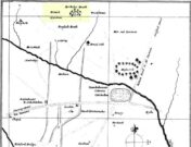
Stukeley’s 1759 map

This once large hillfort was described in the Colchester township perambulations of 1671 and cited in Philip Morant’s classic work. (1748) He told how the boundary line ran “under Chesterwell along the Rampiers by Horkesley Heath,” and which P.H. Reaney (1935) tells was our wooded hillfort.  In Morant’s day, the place was all but complete and so would have been well recognised by local people.   Certainly it came the attention of the great antiquarian William Stukeley who, in 1759, came to Colchester and met with Morant.  Stukeley mainly surveyed the area south of here, at Lexden Heath, but one of his sketch maps clearly highlighted a place he called “a circular work on Horkesley Heath”, i.e., Pitchbury Rings.  The site seems to have remained relatively intact until the middle of the 19th century when a local land-owner took it upon himself to plough over and vandalise much of the site, leaving only a small proportion of the earthworks that we can still see to this day.

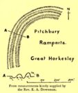
The ruins were described in I.C. Gould’s (1903) piece for the Victoria County History, where he told, at Great Horkesley,

Gould’s 1903 sketch of the remains
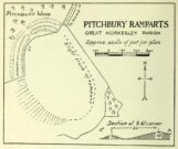
Royal Commission’s 1923 ground-plan

“are some remains of an earthwork known as ‘Pitchbury’ or ‘Pitsbury Ramparts.’  When the late Rev. Henry Jenkins described the camp in 1841, he stated that it was of oval shape, and contained about 6 acres.  Most of it was levelled for agricultural operations about fifty years ago, but there are still some remains, consisting of two banks with their accompanying ditches.  The lines moreover of that part which was destroyed, can be partially traced in the adjoining fields.”

When the Royal Commission (1922) doods wrote about the site nearly twenty years later, things hadn’t changed too much and they simply reported how the “ramparts have nearly disappeared, except for the north section.”  In this “imperfect” condition, as they called it, they gave the following brief description:

“Pitchbury Ramparts, in Pitchbury Wood, about 2 mile south of the church, are the north end of a large camp, roughly oval in shape, and defended by a double rampart and ditch.  The defences are well preserved in the wood, the inner rampart being 10 ft. above the ditch, which is 60ft wide from crest to crest, but the greater part of the work has been almost obliterated by the plough, and is now only faintly discernible in a large field S. of the wood.  The camp appears to have been 800 ft. long and 600 ft. wide.”

Thankfully there seems to have been no real increase in damage to the site since then.  It was excavated in some detail in 1933 and again in 1973 and the finds were published by the highly reputable Colchester Archaeological Trust, whose subsequent report by Hawkes & Crummy (1995) is required reading for anyone wanting to know the detailed archaeology of this and other sites in the area.

Folklore

An intriguing piece of folklore was described in John Round’s (1882) history of the early battles around Colchester Castle.  During the time when the Roman Empire was starting to crumble, the great Pictish tribes of Scotland ventured here and, we are told, took control of the Pitchbury Rings where they stayed before attacking Colchester Castle.

“Traces have been discovered of some violent catastrophe, possibly the first capture of the Colony by the marauding Picts from the North.  Allured, in one of their Southern raids, by the wealth of the goodly Colony, they swooped down like eagles on their quarry from the wooded heights of ‘Pictsbury’.”

References:

  1. Gould, I. Chalkley, “Ancient Earthworks“, in Victoria History of the County of Essex – volume 1, Archibald Constable: Westminster 1903.
  2. Hawkes, C.F.C. & Crummy, Philip, Colchester Archaeological Report 11 – Camulodunum 2, Colchester Archaeological Trust 1995.
  3. Hogg, A.H.A., British Hill-forts – An Index, BAR: Oxford 1979.
  4. Kemble, James, Prehistoric and Roman Essex, History Press: Stroud 2009.
  5. Morant, Philip, The History and Antiquities of the Most Ancient Town and Borough of Colchester, W. Bowyer: London 1748.
  6. Round, John H., The History and Antiquities of Colchester Castle, Benham 1882.
  7. Royal Commission Ancient Historical Monuments, England, An Inventory of Historical Monuments in Essex – volume 3, HMSO: London 1922.
  8. Reaney, P.H., The Place-Names of Essex, Cambridge University Press 1935.
  9. Watson, J.Y., Sketches of Ancient Colchester, Benham & Harrison: Colchester 1879.

Acknowledgements:  Big thanks for use of the 1st edition OS-map in this site profile, Reproduced with the kind permission of the National Library of Scotland

© Paul BennettThe Northern Antiquarian


Uphall Camp, Ilford, Essex

Hillfort (destroyed):  OS Grid Reference –TQ 4383 8510

Archaeology & History

Uphall Camp, 1893

This prehistoric site was a giant – a huge colossus of an ‘enclosure’, a ‘settlement’, a ‘camp’—call-it-what-you-will.  More than a mile in circumference and with an internal area of 48 acres (big enough to hold 37 football fields!), archaeologist Pamela Greenwood (1989) told us, not only that it was “the largest recorded hillfort in Essex”, but that it compared in size with the immensity of Maiden Castle in Dorset!  Yet despite it being cited by the Oxford Archaeology report of Jonathan Millward (2016) as “the most significant archaeological site within the Borough” from the Iron Age period, it has fallen prey to the thoughtless actions of the self-righteous Industrialists who, as usual, have completely destroyed it.  It was already in a “bad” state when the Royal Commission lads visited here around 1916, saying how it was “in some danger of destruction.” Thankfully, in earlier centuries, we did have more civilized and educated people who seemed proud to describe what there was of their local history.

Early literary accounts seem sparse; although in Mr Wright’s (1831) huge commentary to Philip Morant’s (1768) Antiquities of Essex, he thought that the adjoining parish of Barking—whose ancient boundary line is marked here by the southern embankments of the enclosure—derived from the Saxon words burgh-ing, which he transcribed as ‘the fortress in the meadow’.  The same derivation was propounded in Richard Gough’s 1789 edition of Camden’s Britannia, from the “Fortification in the meadows.”  It seems a more reasonable derivation than that ascribed in the Oxford Names Companion (2002) as the “(settlement of) the family or followers of a man called *Berica” (the asterisk here denotes the fact that no personal name of this form has ever been found and is pure guesswork).  But according to the English Place-Name Society text on Essex by Paul Reaney (1935), the early spellings of Barking implies a derivation from ‘birch trees.’  Anyway….
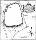
Uphall Camp c.1735

A fine plan of the site was drawn by John Noble some time around 1735 although, curiously, he seems to have written no notes about the place.  The first real citation of Uphall Camp as an antiquity seems to have been by Morant himself (1768).  In a work bedevilled by genealogical and ecclesiological tedium, he occasionally breaks from that boredom to tell of the landscape and the people living here, mentioning our more ancient monuments—but only in passing, as illustrated here:

“Near the road leading from Ilford to Berking, on the north west side of the brook which runs across it, are the Remains of an ancient Entrenchment: one side of which is parallel with the lane that goes to a farm called Uphall; a second side is parallel with the Rodon, and lies near it; the third side looks towards the Thames; the side which runs parallel with the road itself has been almost destroyed by cultivation, though evident traces of it are still discernible.”

Just over thirty years later we were thankfully given a more expansive literary portrayal by Daniel Lysons. (1796)  Lysons was drawing some of his material from a manuscript on the history of Barking by a Mr Smart Lethieullier, written about 1750 (this manuscript was unfortunately destroyed by fire, and no copies of it ever made).  He told us:

“In the fields adjoining to a farm called Uphall, about a quarter of a mile to the north of Barking-town, is a very remarkable ancient entrenchment: its form is not regular, but tending to a square; the circumference is 1792 yards, (i.e., one mile and 32 yards,) inclosing an area of forty-eight acres, one rood, and thirty-four perches.  On the north, east, and south sides it is single trenched: on the north and east sides the ground is dry and level (being arable land), and the trench from frequent ploughing almost filled up: on the south side is a deep morass: on the west side, which runs parallel with the river Roding, and at a short distance from it, is a double trench and bank: at the north west corner was an outlet to a very fine spring of water, which was guarded by an inner work, and a high keep or mound of earth.  Mr. Lethieullier thinks that this entrenchment was too large for a camp: his opinion therefore is, that it was the site of a Roman town.  He confesses that no traces of buildings have been found on that spot, which he accounts for on the supposition that the materials were used for building Barking Abbey, and for repairing it after it was burnt by the Danes.  As a confirmation of this opinion, he relates, that upon viewing the ruins of the Abbey-church in 1750, he found the foundations of one of the great pillars composed in part of Roman bricks. A coin of Magnentius was found also among the ruins.”

But this is a spurious allusion; albeit an understandable one when one recognizes that the paradigm amongst many writers at the time was to say that anything large and impressive was either a construction of the Romans or the Danes, as the early British—it was deemed—were incapable of building such huge monuments.  How wrong they were!

In Mrs Ogborne’s (1814) description of Uphall Camp, she thought that its form and character betrayed anything Roman and—although she wasn’t specific—seemed to prefer the idea that our earliest Britons had built this place.  And she was right!  She wrote:

“There is, about a quarter of a mile from Barking, adjoining Uphal farm, on the road to Ilford, an antient entrenchment, a mile and 32 yards in circumference, with the corners rounded off; the west side, parallel with the river Rodon, has a double trench and bank, and a high keep, or mound of earth, about 94 yards round the base, about nine in height, on the side of the river, and seven on the opposite side: there was an outlet to a spring of water at the north-west corner; the south side has a morass; the north and east sides are single trenched, which is almost lost by cultivation, and in some places barely discernible.”

Uphall Camp on 1873 map

Uphall Camp on 1897 map

When the Ordnance Survey lads gave the site their attention in the 1870s, they showed its real size for the first time—cartographically at least!  As the two old maps either side here show, it was a big one!  Although some sections of the edges of the ‘camp’ were diminishing at the time, much of it was still in evidence.  And when the local writer Edward Tuck (1899) wrote about it, he told us,

“On the north and east sides the ground is dry and level (being arable land) and the trench from frequent ploughings is almost filled up. On the south side is a deep morass; on the west side which runs parallel with the river Roding, and at a short distance from it is a double trench and bank; at the north-west corner is an outlet to a very fine spring of water, which is guarded by an inner work and a high keep or mound of earth designated “Lavender Mound.”  Mrs. Ogborne in her History of Essex gives a charming drawing of this mound as it was in 1814, and says that the mound was then about 94 yards round the base, and about nine yards in height, with trees growing upon it, and its surface covered with soft verdure.”
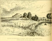
Uphall earthworks in 1893

Several other writers mentioned the remaining embankments of Uphall Camp, which was beginning to fade fast as the city-builders spread themselves further afield.  A chemical factory did most of the damage (as they still do, in more ways than one!).  When the Royal Commission (1921) lads came here they curiously deemed it as an “unclassified” structure; but in those days unless things were Roman in this neck of the woods, it could unduly puzzle them!  Their account of it told that,

“the remaining earthworks consist of a short length of rampart with an irregularly shaped mound at the north end, which is known locally as Lavender Mount, and another short length north of the farmhouse; there are also traces of the east side of the camp running parallel with Barking Lane.  An early plan shows part of the north and east sides of the earthwork and suggests that it was roughly rectangular in outline.  In 1750 the north, east and south sides are said to have had a single trench, and the west side a double trench and bank.

“The mound is 21 ft. high and 85 ft. in diameter at the base. The date of the earthwork is doubtful, but it does not appear to be pre-Roman.”

1908 photo of Lavender Mount

1814 sketch of Lavender Mount

The ‘Lavender Mount’ aspect in this monument, seemed a peculiar oddity.  Even modern archaeologists aren’t sure of what it might have been, erring on the side of caution with interpretations saying it was a keep of some sort, or a small beacon hill.  It might have been of course; but if it was a beacon hill, there would very likely be some written account of it – but none exist as far as I’m aware.  Initial impressions when just looking at the images is that it was a tumulus, but the position of the mound on top of the raised earthen embankments tells us that it was constructed after the Iron Age ramparts.  Writers of the Victoria County History (1903) said the same, suggesting a Saxon or more likely Danish origin.  The area around Lavender Hill was eventually explored by archaeologists in 1960, and several times thereafter – and what they uncovered showed us a continuity of usage that spanned several thousand years!

The 1960 excavation took place where, adjacent to the embankment, “the bank and ditch contained middle-Iron Age pottery”, along with traces of the large wooden fencing-posts (palisade) that initially surrounded and protected the enclosure. In Pamela Greenwood’s (1989) archaeological report, she told us that in further digs in 1983-4 there were discoveries of neolithic and Bronze Age flint remains.  The finds included,

“a leaf-shaped arrowhead and a discoidal scraper… fragments of an Ardleigh type urn, probably from a middle Bronze Age burial disturbed by later activity.  An L-shaped ditch, possibly part of an enclosure or field boundary, was found during the watching-brief. It contained flint-gritted pottery, perhaps attributable to the Bronze Age.”

But the majority of the finds at Uphall came from the mid-Iron Age period.  Greenwood continued:

“The settlement, judging from the relatively small area of the fortification actually excavated, was laid out in a regular way.  As might be expected, the round-houses appear to be aligned, indicating some sort of street-pattern.  ‘Four-poster’ structures have been located in particular areas, again pointing to some sort of designation of special zones of activity. Large quantities of charred grain from the post-pits and surroundings would confirm that these structures are granaries….

“The middle Iron Age structures are of several types: round-houses or round-buildings, pennanular enclosures, (wooden) ‘four-posters’; rectangular structures, ditches, post-holes and innumerable and ill-assorted small pits, small gullies and holes dug into the gravel.  Many of the last three types are undatable and could belong to the Iron Age, Roman, medieval or later activity on the site.”

I could just copy and paste the rest of Greenwood’s report here, but it’s quite extensive and interested readers should refer to her own account in the London Archaeologist .  It’s a pity that it’s been destroyed.

References:

  1. Crouch, Walter, “Ancient Entrenchments at Uphall, near Barking, Essex,” in Essex Naturalist, volume 7, 1887.
  2. Crouch, Walter, “Uphall Camp,” in Transactions of the Essex Archaeological Society, volume 9 (New Series), 1906.
  3. Doubleday, H.A. & Page, William (eds.), Victoria History of the County of Essex – volume 1, Archibald Constable: Westminster 1903.
  4. Greenwood, Pamela, “Uphall Camp,” in Essex Archaeology & History News, 1987.
  5. Greenwood, Pamela, “Uphall Camp, Ilford, Essex,” in London Archaeologist, volume 6, 1989.
  6. Hogg, A.H.A., British Hill-Forts: An Index, BAR: Oxford 1979.
  7. Kemble, James, Prehistoric and Roman Essex, History Press: Stroud 2009.
  8. Lysons, Daniel, The Environs of London – volume 4, T. Cadell: London 1796.
  9. Millward, Jonathan, London Borough of Redbridge: Archaeological Priority Areas Appraisal, Oxford Archaeology 2016.
  10. Morant, Philip, The History and Antiquities of Essex – volume 1, T.Osborne: London 1768.
  11. Norris, F.J., “Uphall Camp”, in Gentleman’s Magazine, 1888.
  12. Ogborne, Elizabeth, The History of Essex, Longmans: London 1814.
  13. Royal Commission Ancient & Historical Monuments, England, An Inventory of the Historical Monuments in Essex – volume 2, HMSO: London 1921.
  14. Tuck, Edward, A Sketch of Ancient Barking, Its Abbey, and Ilford, Wilson & Whitworth: Barking 1899.
  15. Wilkinson, P.M., “Uphall Camp,” in Essex Archaeology & History, volume 10, 1979.
  16. Wright, Thomas & Bartlett, W., The History and Topography of the County of Essex – volume 2, G. Virtue: London 1831.

© Paul BennettThe Northern Antiquarian


Broad Oak, Hatfield Broad Oak, Essex

Legendary Tree:  OS Grid Reference – TL 5352 2083

Also Known as:

  1. Doodle Oak

Archaeology & History

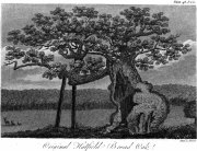
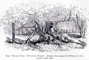
Hatfield’s Doodle Oak, 1807

Erroneously ascribed by the reverend Winsland (1952) as being the ‘Doodle Oak’, the ancient and giant tree called the Broad Oak was, as records show, always known by this name, but was subsequently replaced by another after its demise.  It was this second tree that became known as the Doodle Oak.  Winsland described it as “an immense and famous oak tree”, under whose “spreading branches in olden days the Lord of the Manor probably held his court and dispensed justice.”

The tree was described as early as 1136 AD and was probably an early tribal meeting site, or moot spot.  In Philip Morant’s (1763) work, he described it as,

“A tree of extraordinary bigness. There has been another since…called Doodle Oak.”

The old Oak in 1890

The Doodle Oak was thought to date from around 10-11th century and its predecessor may have been upwards of a thousand years old before this one took its place.  In 1949, one patient botanist, Maynard Greville, investigated the Doodle Oak tree-rings and found it to be 850 years old.  Other estimates suggest it was a hundred years older than that!  Whichever was the correct one, a measurement of its trunk found it to be some 19 yards in circumference – one of the largest trees ever recorded in Britain!

Sketches of its dying body were thankfully made near the beginning and the end of the 19th century: one in Mr Vancouver’s (1807) Agriculture of Essex, and the other by Henry Cole of the Essex Naturalist journal.

Doodle Oak on 1896 map

Some speculate that the Broad Oak of ancient times and the subsequent Doodle Oak were at very different places in the parish, but without hard evidence this idea is  purely hypothetical.  And whilst the name ‘broad’ oak is easily explained, the name ‘doodle’ is slightly more troublesome.  However, a seemingly likely etymology is found in the Essex dialect word dool, which Edward Gepp (1920) told,

“seems to mean, (1) a landmark; (2) a path between plots in a common field.”

The former of the two would seem to be the most likely.  This is echoed to a greater degree in Wright’s (1900) magnum opus, where he found the dialect word dool all over the southeast, meaning,

“a boundary mark in an unenclosed field.”

Giant trees on ancient boundaries, like the Broad Oak of earlier times, would seem to be the most probable reason for its name.  Today, all that’s left of the site is a small plaque on a small tree-stump, telling us what once stood here…

References:

  1. Gepp, Edward, Contributions to an Essex Dialect Dictionary, George Routledge: London 1920.
  2. Morant, Philip, The History and Antiquities of the County of Essex – volume 2, 1763.
  3. Reaney, P.H., The Place-Names of Essex, Cambridge University Press 1935.
  4. Vancouver, Charles, General View of the Agriculture of the County of Essex – volume 2, Richard Phillips: Blackfriars 1807.
  5. Winsland, Charles, The Church of Saint Mary the Virgin, Hatfield Broad Oak, Anchor: Bishop Stortford 1952.
  6. Wright, Thomas, English Dialect Dictionary – volume 2, Henry Frowde: London 1900.

© Paul BennettThe Northern Antiquarian


Holy Well, Barking, Essex

Holy Well (destroyed):  OS Grid Reference – TQ 4421 8484

Archaeology & History

Barely 200 yards to the immediate southeastern edge of the once gigantic hillfort of Uphall Camp, could once be found an old holy well, last recorded it would seem in 1456.  The site was located just yards to the south of the old boundary that separates the parishes of Ilford and Dagenham.  Its location was described in the Victoria County History:

“A mile south of Ilford Bridge the Roding is joined by Loxford Water, a stream rising near Hog Hill, in Dagenham, and known in its upper reaches as Seven Kings Water. In 1456 the lower part of the stream was called Halywellbrooke.”

We also have an account in the Barking Abbey Rental, which told us there was “land in Longland at Halywellbrooke”, as well as “pasture lying at the northern head of Luzias land…near Halywell and…at Loxfordbrigge.” (Harte 2008)  It has long since been destroyed.

References:

  1. Harte, Jeremy, English Holy Wells – volume 2, Heart of Albion Press: Marlborough 2008.
  2. Powell, W.R. (ed.), A Victoria County History of Essex – volume 5, OUP: London 1966.

LinksHoly Well, Barking on The Megalithic Portal


St. Botolph’s Well, Hadstock, Essex

Holy Well: OS Grid Reference — TL 559 448

Getting Here

Hadstock lies along the A1052 north of Saffron Walden. Once in the village, a fenced pond will be apparent on the left below the church.  Just above the pond is the well that feeds it – yet there seems some confusion regarding the exact location of the site.

Archaeology & History

John Wilson in his Imperial Gazetteer, III (1872) describes it as:

“A well set round with stones, and called St. Botolph’s Well, is in the churchyard.”

However, by the time of An Inventory of the Historical Monuments in Essex, I (1916) it was:

“In the churchyard—a well, known as St. Botolph’s well, now covered.”

St Botolph's Well

St Botolph’s Well

Indeed there would be some confusion regarding the exact location of this well.  The church guide describes a pump to the west end of the churchyard as the well (but the only pump apparent was that across the road), however I was informed that this well was the one picturesquely situated by the road beneath the church. This is a brick-lined square well whose spring percolates into a pool covered in duckweed.  No evidence of any material earlier than Victorian is apparent, suggesting it may date from when the pump was established.  A wooden fence has been erected around it to prevent people falling in, but apparently the well itself has been covered.

Folklore

The village has a St. Botolph’s Well although there is no direct link recorded between it and the saint of that name, but local tradition believes that he was interred in this church. This view was supported by the discovery of an empty Saxon grave in the east wall of the South Transept. Greater credence being lent by the fact that this had previously been exhumed, which is in accordance with the knowledge that the relics were removed in 970, and then distributed around East Anglia.

Its waters have had a mixed reputation. Tradition records their ability to cure scrofula. Until recently the well was the important source of drinking water for the village. One tradition suggests that if a ring was dropped into it by a lovelorn girl she would find her true love. This tradition was supported by the finding of two rings recently in the cleaning of the well.  Wilson (1970) notes a strange activity was practiced within living memory by the white witch: to keep the water pure, dead cats were placed down the well.  Obviously, this was not continued for on one occasion the water was the harbinger of a typhoid outbreak, and forty percent of the population—or 40 people—died (although there is no evidence for either). The contamination was the result of the Rev F. E. Smith using the spring as an outlet for his lavatory. If this was not bad enough, one of his staff was a typhoid carrier! This is also notwithstanding, that it was commonly believed that the spring water drains from the graveyard above it: and hence it has earned the name ‘bone gravy’. Despite all these traditions, this did not deter the locals, who vouched for its goodness. Even when piped water was brought to the village in the 1930s, many locals could not see the point as the well water was good enough.

References:

  1. Parish, R.B., Holy Wells and Healing Springs of Essex, Pixy Led Publications 2008.
  2. Royal Commission on Historic Monuments, An Inventory of the Historical Monuments in Essex – volume 1, HMSO: London 1916.
  3. Wilson, John M., The Imperial Gazetteer of England and Wales – volume 3, A. Fullarton: Edinburgh 1872.

Extracted from the R.B. Parish Holy Wells and healing springs of Essex (2008)

Links:

  1. Holy & Healing Wells

© R.B. Parish, The Northern Antiquarian


Baston Manor, Hayes, Kent

Settlement:  OS Grid Reference – TQ 407 649

Archaeology & History

This settlement site was found thanks to the good work of the Bromley & West Kent Archaeology Group in the 1960s, when they decided to do follow-up work to what Brian Philp (2002) described as “doubtful sites reported mainly in the 19th century.”  Time and again these “doubtful sites” at least turn into something of value — and such was the case here!  The group commenced digging selective trenches in July 1964 in a small wooded area near to Baston Manor and they soon came across “a stratified deposit of late-Neolithic (2500 BC) pottery and flint.”

In successive returns to the site over two years, 5630 items—primarily fire-cracked stones, flints and more than 200 pieces of pottery, some of which was highly decorative—were unearthed and the site was recognised as an important settlement arena many thousands of years ago.  In Kent, this was a rarity!  Philps’ resumé of the site and its many remains told,

“Sometime about 2500 BC, a group of late-Stone Age farmers had selected this quiet hillside (now just in Hayes) to settle and live.  Here they must have farmed  small cultivated areas close to their huts and herded sheep and cattle to fresh areas and nearby streams.  These were the first occupants of the West Wickham valley over 4000 years ago…”

References:

  1. Philp, Brian, “The Discovery of a Secondary Neolithic Site at Hayes,” in Kent Archaeological Review, no.5, 1966.
  2. Philp, Brian, Archaeology in the Front Line, KARU: Dover 2002.
  3. Smith, Isobel, “Prehistoric Pottery from Baston Manor, Hayes,” in Kent Archaeological Review, no.18, 1969.

Links:

  1. Kent Archaeological Review

© Paul BennettThe Northern Antiquarian


Hickford Hill, Belchamp St Paul, Essex

Enclosure:  OS Grid Reference – TL 7872 4537

Archaeology & History

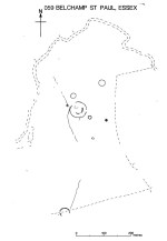
Ground-plan of enclosure & surrounding barrows

Plan of enclosure & surrounding barrows

Several hundred yards northeast from Hickford Hill, a cluster of prehistoric sites could once be seen close to each other just south of the River Stour below line of the Essex-Suffolk county boundary.  Several of these were tombs and are accounted for in Priddy’s (1981) essay on the prehistoric Barrows of Essex; but adjacent to them were also found faint traces of a large circular enclosure of some sort, which Harding & Lee (1987) included in their definitive survey of British henge monuments. Their account of it was brief and simple, saying:

“Enclosure defined by the cropmark of a sub-circular rather narrow ditch broken by two entrances.  No trace of a bank.  Internal traces of a concentric innner ditch in part of the circuit… Internal diameter range 56-57m…; width of outer ditch c.1.5-2.5m; width of entrances, c.7m (E) and 16m (NW); width of inner ditch c.2.5-5m.”

Although this large ringed enclosure was thought by the Haverhill & District Archaeology Group to “be a henge-type monument,” Harding & Lee (1987) thought it unlikely that these remains “belong to the henge class” of monuments.  A brief archaeological dig into one of the trenches here in 1997 showed the site to be Bronze Age; but finds by the local archaeology team have also come across finds in the fields hereby dating from the Mesolithic and Neolithic periods.

References:

  1. Harding, A.F. & Lee, G.E., Henge Monuments and Related Sites of Great Britain, BAR 175: Oxford 1987.
  2. Priddy, D., “The Barrows of Essex,” in A.J. Lawson’s The Barrows of East Anglia, Norfolk Museums Service 1981.

© Paul Bennett, The Northern Antiquarian

Boxted Cross Henge, Colchester, Essex

Henge Monument:  OS Grid Reference – TM 0093 3277

Archaeology & History

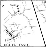
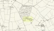
Boxted Henge plan (Colchester Archaeology Group)

Boxted Henge plan (Colchester Archaeology Group)

As with many sites in Southern England, intensive agriculture has taken its toll on the archaic monuments.  The Boxted Cross henge is no exception and hardly any elements of it remains today.  But it seems that it was an impressive fella in our more ancient heathen past.

The site was only rediscovered in the 1970s and was first described in Mrs Ida McMaster’s (1975) survey of crop-marks that had been revealed by aerial surveying in Essex and Suffolk counties.  Her brief account of the monument told it to be,

“A Class II henge with a wide somewhat ploughed out ditch. Various linear ditches are near, together with prolific variegated ‘field outlines’ of glacial subsoil cracking which extends into the next field southwards. The ditch terminals of the southwest entrance to the henge appear to be wider than the general run of the ditch, say 4-5 metres.”

When Harding & Lee (1987) examined the site, they were a little more cautious in their interpretation of it being a definite henge, citing that there was “insufficient information, but cannot be ruled out as henge-related,” adding that it “could also be a mill.”  This latter element seems unlikely, though a windmill may have been built onto the site at a later date.

More recently however the site has been categorized by Historic England as “a Late Neolithic henge.”  The monument itself was defined by a broad circular ditch with two large opposing entrances to the north and south.  The total diameter of the enclosure is 44 yards (40m) across; but with the surrounding ditch measuring 5½ yards (5m) across all around, the inner level of the henge was about 33 yards (30m) in diameter.  Plenty of room for partying old-style!

References:

  1. Harding, A.F. & Lee, G.E., Henge Monuments and Related Sites of Great Britain, BAR 175: Oxford 1987.
  2. McMaster, Ida, “Crop Marks Selected and Plotted,” in Colchester Archaeological Group Bulletin, volume 18, 1975.

© Paul Bennett, The Northern Antiquarian