Acrehowe Cross, Baildon Moor, West Yorkshire

Cross (destroyed):  OS Grid Reference – SE 14390 40601

Also Known as:

  1. Rerehowe Cross

Archaeology & History

‘Rerehowe’ cross on 1852 map

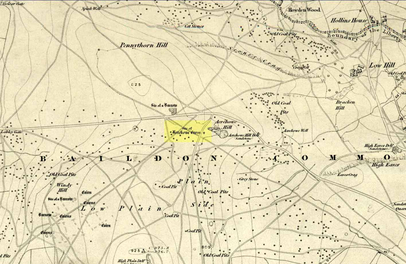
Once found on the other side of the road from the prehistoric circle of Acrehowe Hill, this old cross was destroyed sometime in the first half of the 19th century by one of the stewards to the Lady of the Manor of Baildon, a Mr Walker.  It’s unlikely that Mr Walker would have performed this act without direct orders from the Lady of the Manor, so the destruction should really be laid at the feet of the land-owner, who’ve got a habit of destroying archaeological sites up and down the land, even today.

Found near the crown of a small hill on the horizon whether you’re coming from Eldwick- or Baildon-side, the cross was erected (probably between the 12th and 14th centuries) amidst a cluster of heathen burials and cup-and-rings, many of which would have been known by local peasants as having old lore or superstitions about them.  So the church commandeered this spot, desacralized it and no doubt enacted profane rites around it under the auspice of some spurious christian law.  They did that sorta thing with every non-christian site they ever came across—or simply vandalised it, much as many of them still do today.  Sadly we know not the exact history of the old cross: whether it was an old standing stone on the crown of this hill which they defaced and made into a cross, or whether they erected their own monument, we’ll never know.  But the idea of a once-proud monolith standing here is a strong possibility, considering its position in the landscape and the stone rings of Pennythorn and Acrehowe close by (cup-and-ring stones such as carving no.184 are also close by).

The cross itself once gained an additional incorrect title by the cartographers of the period, who named it Rerehowe Cross—but this was simply a spelling mistake and its newly-found title didn’t last long. The local industrial historian William Cudworth (1876) described the lost cross in his large work, where he told that,

“many of the inhabitants can remember and point out the exact spot where it stood, and no doubt could find some of the stones of which it was composed. It was destroyed by one of the overseers and a large portion of it used for fence stones.”

Harry Speight (a.k.a. ‘Johnnie Gray’) and others also mentioned the passing of this old stone, but give no additional information.

Folklore

In William Cudworth’s description of this site he told how “the village tradition is that it was put up in commemoration of a great battle that was fought on the Moor” at Baildon; but W.P. Baildon (1913) thought this was unlikely.  Instead, he cited an 1848 Name Book reference dug out by W.E. Preston, which told that on the summit of Acrehowe Hill,

“Here stood a cross which, according to traditional evidence was erected at the period that markets were held at Baildon, in consequence of a plague which prevented the country people from visiting the village with provisions, etc.  The site of its base is very apparent, being circular, about 8 feet in diameter.  A large flag stone  with the stump of the cross remaining in its centre, was pulled up and destroyed by Mr Walker (Baildon Hall) a few years since.”

References:

  1. Baildon, W. Paley, Baildon and the Baildons (parts 1-15), St. Catherines: Adelphi 1913-26.
  2. Bennett, Paul, The Old Stones of Elmet, Capall Bann: Milverton 2001.
  3. Colls, J.M.N., ‘Letter upon some Early Remains Discovered in Yorkshire,’ in Archaeologia, volume 31, 1846.
  4. Cudworth, William, Round about Bradford, Thomas Brear: Bradford 1876.
  5. Gray, Johnnie, Through Airedale from Goole to Malham, Walker & Laycock: Leeds 1891.

© Paul Bennett, The Northern Antiquarian 


Brown Law (310), Ilkley Moor, West Yorkshire

Cup-Marked Stone:  OS Grid Reference – SE 13191 46512

Also Known as:

  1. Carving no.149 (Hedges)
  2. Carving no.310 (Boughey & Vickerman)

Getting Here

3 cups gently sleeping

Get to the Cow & Calf Rocks, go up across the car-park as if you’re gonna go up onto the moor and walk up the steep footpath uphill to the left of the crags.  Once you get level with the crags, take the footpath bending left and walk along here for 110 yards, keeping your eyes peeled for the low smooth rock on the right of the footpath, just where another path meets it. You’ll find it.

Archaeology & History

Close-up, from above

This quiet little stone has seen better days.  Nearly destroyed a few weeks ago when the Emmerdale Farm film-crew churned up sections of the moor right over the side of this carving—but thankfully it still remains intact (you or I would have been prosecuted for such damage).* The carving is a simple one in graphic terms, comprising simply of three cup-markings, all on the southern side of the rock.  Close to several other petroglyphs (the Wray Stone is 78 yards north and several other more ornate carvings are close by), the carving was first described in the Hedges (1986) survey as a “small, low smooth grit rock sloping slightly NW to SE in crowberry, bilberry, grass and bracken. Three clear cups.”  But it has to be said, one of them is fading fast.  Let’s hope this humble little carving doesn’t fall prey to those who are gradually turning our moorlands into a park.

References:

  1. Boughey, Keith & Vickerman, E.A., Prehistoric Rock Art of the West Riding, WYAS: Leeds 2003.
  2. Hedges, John, The Carved Rocks on Rombald’s Moor, WYMCC: Wakefield 1986.
* As the footpaths on Ilkley Moor continue to be widened and paved by those who reckon they like these moors, it’s obvious that more prehistoric sites up here are going to get damaged. It’s difficult to see what the local archaeologist or Natural England are doing to ensure that these environmentally-damaging schemes don’t encroach on the mass of rich prehistoric sites on the moors, most of which have never been adequately assessed (the philosophy of “if we don’t know it’s there, it doesn’t matter if we destroy it” seems evident in some of those working for the local council). Before any work or structures are dug on Ilkley Moor, an archaeological assessment is, I believe, supposed to take place – but I think this ‘work’ consists merely of looking at their own limited records, without any detailed fieldwork being undertaken. As we know from research undertaken by rock art students at TNA, CSI and elsewhere, there are still many cup-and-ring stones, cairns and archaeological features constantly being discovered on these moors that are not in the record books.

© Paul Bennett, The Northern Antiquarian


Holy Well, Humphrey Head, Allithwaite, Cumbria

Holy Well:  OS Grid Reference – SD 3901 7392

Getting Here

Early photo of holy well site (Henry Taylor, 1906)

To get here you have to travel right to the end of the road, then walk a short distance until you hit the horrible coastal waters where there’s a natural rock arch. Just before here, on the west-facing side, is this famous holy well.

Archaeology & History

Just before this little-known sacred well is a cavity in the limestone rock which is called the Fairy Church, and a couple of hundred yards below here is another one which was known as the Fairy Chapel.  This region was obviously of sacred importance to our ancestors – and should still be to those of us with ecological concerns.  The waters from this well were said to cure poisons from the body.  It was written about at some length in Mr Taylor’s (1906) superb survey, where he collated material from a series of other early tracts describing the well.  He wrote:

“This celebrated medicinal well is said to have been used by lead miners from the time of the Romans. The patients come for a two or three days’ stay to “get the poison out of their systems.” The site is three and a half miles nearly due south from Cartmel. The water, which has a very peculiar taste, comes down from the hillside and flows into a small artificial basin or grotto. The key of the door is kept at a neighbouring farmhouse. Close to the well is an untenanted building formerly used by indigent sufferers. The wooded cliff forming ‘The Head’ is of singular beauty, overlooking the waters and sands of Morecambe Bay. On Hennet’s map of Lancashire (1828) the well is called ‘Spa Holy Well.’

“…Mr. W. O. Roper, in his Churches, Castles, and Ancient Halls of North Lancashire, writes: “One other appendage to the Priory of Cartmel should be mentioned, and that is the well known as the Holy Well. On the sea-shore, close under the towering cliffs of Humphrey Head, and almost immediately below the natural arch of rock which leads to the recess known as the Fairy Chapel, bubbles the well to which in former days the Priors journeyed in state from their neighbouring Priory, and to which in more recent times large numbers of people resorted, hoping to derive benefit from its medicinal qualities.”

“Mr. James Stockdale, in Annals of Cartmel, writes: “Near to this holy well (Humphrey Head) are two cavities in the mountain limestone rock called the ‘Fairy Church’ and the ‘Fairy Chapel,’ and about three hundred yards to the north there used to be another well, called ‘Pin Well’, into which in superstitious times it was thought indispensiable that all who sought healing by drinking the waters of the holy well should, on passing it, drop a pin; nor was this custom entirely given up till about the year 1804, when the Cartmel Commoners’ Enclosure Commissioners, on making a road to Rougham, covered up this ‘Pin Well’. I have myself long ago seen pins in this well, the offerings, no doubt, of the devotees of that day.”

“Mr. Hope, in his Holy Wells of England, says that “this is a brackish spring celebrated as a remedy for stone, gout, and cutaneous complaints.  The water issues from a projecting rock of limestone, called Humphrey Head and its medicinal qualities occasion a considerable influx of company to Cartmel, Flookborough, Kent’s Bank and Grange during the summer months…”

Holy Well on 1851 map

The site was clearly marked in 1851 on the first OS-map of the area as the Holywell Spa, and the attendant Fairy Chapel and Fairy Church shown as two distinctly separate places, very close by.

References:

  1. Hope, Robert Charles, Legendary Lore of the Holy Wells of England, Elliott Stock: London 1893.
  2. Taylor, Henry, The Ancient Crosses and Holy Wells of Lancashire, Sherratt & Hughes: Manchester 1906.

© Paul Bennett, The Northern Antiquarian


Rudstoop Monolith, Cragg Vale, West Yorkshire

Standing Stone/s:  OS Grid Reference – SD 99269 23652

Getting Here

Site on 1st edition OS-map

From Mytholmroyd, go up the Cragg Vale Road, then 2 miles up take the road steep on your right down and round St. John’s Church, then keep going along the road up to Withens.  About a mile up, a road turns sharply right.  Go up here for a few hundred yards, past the trees, and 100 yards on the road splits in a ‘V’.  Stop here.  Go into the field on your left which slopes downhill and less than 100 yards down you’ll see the large long stone laid in the grass.  That’s it!

Archaeology & History

The fallen stone, with Teddy! (image courtesy ‘QDanT’)

Included in the Addenda of The Old Stones of Elmet (p.222), here is a recumbent monolith more than 8 feet long and 6 feet across which really needs to be resurrected as it would be an impressive sight! Found halfway up Withens Clough, a local land-owner told me it was one in a row of several such stones, though no trace of the others can be found. Found in the appropriately called Standing Stone Fields, it was last shown on the 1850 OS-map, as the attached illustration shows and is positioned just above the “S” of the smaller highlighted “standing stone”, just where the little blob is! The small valley to its immediate west is called Rudstoop, from which I give the stone its name.

A description of the site is given in F.A. Leyland’s scarce commentary on the History of Halifax (c.1867), where he wrote:

“Standing Stone Fields: Not far distant from Hill Top, in this township (Erringden), there is a rough piece of ground known by this name.  It is situated on the slope of the same hill as the remain last described and commands a view of the northern side of Sowerby, with the outlines and rocks of Langfield and the Withens. The locality was anciently the site of a number of upright single stones: most of these have been broken up and used in the construction of the adjoining fences. But one, the last of the series, which the quarrying operations on the spot respected during the whole time they were carried on, was undermined and overthrown a few years ago, by a number of mischievous boys. The rock is a slab of millstone grit, measuring upwards of 9 feet in length, 7 feet 8 inches in width, at the base, and 4 feet 9 inches at the top: at the latter point it is 9 inches thick, and is 1 foot 6 thick at the base. The remain has, originally, been pyramidal in form, but the apex has been either broken off by violence or reduced to its present dimensions by decay.”

An impression of the land here indicates the other, lost monoliths, were in a row which headed east from here, towards the cup-and ring-marked ‘Upper Lumb Stone’.  There is also the possibility that these monoliths were aligned with the enigmatic Two Lads cairns less than a mile SW of here.

Well worth checking out!

References:

  1. Bennett, Paul, The Old Stones of Elmet, Capall Bann: Milveton 2001.
  2. Leyland, F.A., The History and Antiquities of the Parish of Halifax, by the Reverend John Watson, M.A., R.Leyland: Halifax n.d. (c.1867)

Links:

  1. More images of the fallen monolith

© Paul Bennett, The Northern Antiquarian


Barmishaw Stone, Ilkley Moor, West Yorkshire

Cup-and-Ring Stone:  OS Grid Reference – SE 11193 46417

Also Known as:

  1. Barnishaw Stone
  2. Carving I/4 (Davies)
  3. Carving no.92 (Hedges)
  4. Carving no.253 (Boughey & Vickerman)

Getting Here

The Barmishaw Stone

Follow the same directions to reach the superb Badger Stone carving, and from here take the footpath that runs downhill.  You’ll cross another footpath about 100 yards down the moor, but just keep walking down the path and you’ll notice the small copse of woods ahead of you.  As the footpath begins to swerve roughly away, northeast, heading away from the said woodland, keep your eyes peeled on your left for a reasonably large but flattish rock close to the ground (in summer it’s surrounded by bracken) about 75 yards away.  That’s your target!

Archaeology & History

Of the hundreds of cup-and-ring stones on Ilkley Moor and district, this is one of my personal favourites!  I first visited the stone in 1977 as a young teenager and was mightily impressed by the unusual nature of the design here — and that impression still remains.  Aswell as possessing the usual cups and rings, the Barmishaw Stone is one of just a few rocks also possessing a sort of ‘ladder’ design or linear pattern within the overall carving: an insignia echoed on the nearby Willie Hall Wood carving, the Piper Stone, and also on the Panorama Stones.  As with the ‘ladders’ on the Panorama carving, those found here at Barmishaw are very eroded and are increasingly difficult to see during the daytime (the best time to notice them is usually around sunrise or sunset, and particularly when the rock itself is wet).

The carving has been described many times, albeit briefly, by a number of writers.  In John Hedges (1986) fine survey he said the following:

Barmishaw Stone, looking northwest
Barmishaw Stone, looking southeast

“Medium sized flat-topped rock…fairly smooth grit, sloping slightly east to west, covered with carvings, some of which are very worn.  Slanting sunshine needed to detect them.  About twenty-four cups, at least nine with rings or incomplete rings, two with multiple grooves half round and continuing straight down, one of them incorporating ‘ladder.’  Five other ‘ladders’ – in a good light.  Cups mostly deep and clear.”  A few years later, Boughey & Vickerman (2003) echoed much of Mr Hedges description, though noted that of the 24 cups with their rings, one possessed a triple ring.

Alan Davies’ illustration

Like so many cup-and-ring stones, they have given rise to hosts of fascinating theories and ideas — one of which is based on mathematics and metrology.  In the 1980s, Alan Davies (1983, 1988) surveyed the Barmishaw Stone — and other carvings on Ilkley Moor — to explore the possibility that the cups and rings were laid out according to a basic unit of measure, the Megalithic Inch (MI), as proposed by Alexander Thom some years earlier.  Although Davies’ work showed that such a primary unit of measure wasn’t to be found universally, his research at the Barmishaw Stone indicated “significant evidence for quanta of…3 MI,” although this occurred “when the analysis is restricted to only ringed cups.”  Despite this, Davies thought that the existence of the Megalithic Inch was evident in this and other carvings on the moors, stating that:

“The repeated emergence of the significance of ringed cups, and the fact that all putative quanta seem to bear a simple numeric relation to each other do not seem to be coincidental.”

Although it has to be said that the selectivity of data in Davies’ research is more indicative that the Megalithic Inches in the the carvings was due, neither to chance nor mathematics, but more that the implements used to carve the rocks and the size of the hands of the people doing the carvings was pretty uniform and so, as a result, would give an obvious window of numeric similarities that can easily be mistaken as a deliberate metrology.  These simplistic factors need assessing.  In modern trials that we’ve done carving cup-markings, we’ve found them to be of similar size to those carved in prehistoric times—as you’d expect.

Barmishaw Stone (after Hedges, 1986)
Barmishaw stone (Cowling 1946)

The ladder motif central to this carving may have related to early religious and ritual events here.  Across the world, indigenous cultures commonly relate the ‘ladder’ to be a symbol of ascension, both by shamans, mystics and during rites of passage.  The symbol represents the journey of the soul to and from supernatural realms.  To discount this possibility at the Barmishaw Stone would be shortsighted.

The carving was very probably painted when our neolithic ancestors gathered here, much as Australian aborigines still do to their carvings using lichens and other plant dyes, with the respective ladders and lines changing colour where movements between worlds or shifts of attendant spirit occurred.  By virtue of the its very name, I consider this rock to have been considerably important; the “ghost” aspect to barmishaw being a typically misconstrued aspect of ‘spirit’.

Folklore

This excellent cup-and-ring marked stone probably derives its name from the old dialect words “barm i’ t’ shaw”, meaning “ghost in the wood” stone.  Whatever guise the attendant spirit of this rock may have had has long since been forgotten; though spectral accounts from the beginning of the nineteenth century until modern times may give us clues.  There have been several reports of green-coloured elemental creatures around the area between here and the White Wells sacred spring a short distance to the east.  The most recent account, from 1987, took on the modern mythic form of a little green man from space, with attendant UFO to boot!  The Barmishaw Hole nearby was a place where faerie-folk used to live.  Excesses of geological faulting and water makes the magickal nature of this place particularly potent.

References:

  1. Allen, J. Romilly, “The Prehistoric Rock Sculptures of Ilkley,” in Journal of the British Archaeological Association, volume 35, 1879.
  2. Allen, J. Romilly, “Notice of Sculptured Rocks near Ilkley,” in Journal of the British Archaeological Association, volume 38, 1882.
  3. Bennett, Paul, “Cup-and-Ring Art”, in Towards 2012, volume 4, pp.83-92, 1998.
  4. Bennett, Paul, The Old Stones of Elmet, Capall Bann: Milverton 2001.
  5. Boughey, Keith & Vickerman, E.A., Prehistoric Rock Art of the West Riding, WYAS: Wakefield 2003.
  6. Cowling, E.T., ‘A Classification of West Yorkshire Cup and Ring Stones,’ in Yorkshire Archaeological Journal 1940.
  7. Cowling, E.T., Rombald’s Way: A Prehistory of Mid-Wharfedale, William Walker: Otley 1946.
  8. Davis, Alan, ‘The Metrology of Cup & Ring Carvings near Ilkley in Yorkshire,’ Science Journal 25, 1983.
  9. Davies, Alan, ‘The Metrology of Cup and Ring Carvings,’ in Ruggles, C., Records in Stone, Cambridge University Press 1988.
  10. Eliade, Mircea, Patterns in Comparative Religion, Sheed & Ward: London 1958.
  11. Hedges, John (ed.), The Carved Rocks on Rombalds Moor, WYMCC: Wakefield 1986.
  12. Wright, Joseph, The English Dialect Dictionary – volume 1, Henry Frowde: Oxford 1905.

© Paul Bennett, The Northern Antiquarian 


St Austin’s Stone, High Hunsley, East Yorkshire

Legendary Rock:  OS Grid Reference – SE 93360 34443

Also known as:

  1. St. Augustine’s Stone
  2. St Austin’s Rock

Folklore

St Austins Stone on 1855 map

The folklorist John Nicholson (1890) wrote about this “block of natural concrete standing at the head of Drewton Dale, near South Cave” — which modern OS-maps call Austin Dale.  Legend told how it “derived its name from St. Augustine, who used to preach from this stone to the heathen, before Britain became christian.”  This obviously supplanted an earlier heathen site, but it’s difficult to work out what that may have been.  It could have been the lost ‘Rud Stone’ immediately west; or perhaps had some traditional relationship with the healing well which emerges a short distance away further down the valley.  Just above here as well, we find an ancient dragon’s lair at Drakes Hole, which could also hold a clue to this place.

A couple of years after Nicholson mentioned the site, John Hall (1892) published his excellent history of the township, in which he described St. Austin’s Stone thus:

“It’s a mass of rock projecting from the side of a hill and in its longest part, extending  from the hillside to the face of the stone, measures about 60 feet.  By some it is supposed to have formed a centre for druidical worship, and that the adjoining township took its name of Drewton (or Druid’s Town) from this fact.  When St. Augustine came to England…he is said to have visited this part of the East Riding; and that this stone took its name from his visit.”

St Austins Stone 1890 map

The site was also surmounted by a cross at some time in its recent history, but this has gone.  The earth mystery writer Philip Heselton (1986) told that the nearby Well was indeed a place connected to St. Austin’s Stone, in an early article in Northern Earth Mysteries, saying:

“St. Austins Stone near South Cave is a rock outcrop where Saint Augustine is said to have made converts, baptizing them in a nearby well. The site is used for church services.  Every seven years, part of the stone falls away, but it always grows again.”

The site should be examined for potential cup-and-ring markings; as well as reports on the status of the Well.  Any photos of the present situation of the site would be most welcome.

References:

  1. Gutch, Mrs E., County Folk-Lore volume VI: Examples of Printed Folk-lore Concerning the East Riding of Yorkshire, David Nutt: London 1912.
  2. Hall, John George, A History of South Cave and other Parishes in the East Riding of Yorkshire, Edwin Ombler: Hull 1892.
  3. Nicholson, John, Folk Lore of East Yorkshire, Simpkin Marshall: London 1890.
  4. Thompson, Thomas, Researches into the History of Welton and its Neighbourhood, privately printed: Kingston-upon-Hull 1869.

Links:

  1. St. Austin’s Stone (and Well) on “Yorkshire’s Holy Wells” website

© Paul Bennett, The Northern Antiquarian


Nussey Green (404), Appletreewick, North Yorkshire

Cup-Marked Stone:  OS Grid Reference – SE 0739 6254

Getting Here

Nussey Green CR404 (after ‘QDanT’)

Park at Stump Cross Caverns on the B6265 road, then walk down the road for 200 yards till you reach the track on your left running over the fields in the direction towards Simon’s Seat.  Walk on the track for about 600 yards until there’s a change of direction in the adjacent walling and then watch out for the dirt-track on your right, curving towards the small valley (if you hit the Skyreholme Wall carving (413), you’ve gone 100 yards past the turn-off). Go on here until you see the overgrown track on your left into a small disused quarry, and head right, down the grassy slope, checking out the few stones ion front of you 20 yards down.  You’re damn close!

Archaeology & History

Carving no.404 (after Boughey & Vickerman)

A simplistic carving that was first described by fellow antiquarian Stuart Feather (1964), this is one of at least four cup-marked stones in a small group here, above the valley of Skyreholme Beck — better known at this part of the valley as the Troller’s Ghyll, haunt of various heathen lore.  Although some of the carving has now been covered by the growing Earth, you can still see the majority of the design.

It is a flat, roughly triangular stone described by rock art students Boughey & Vickerman (2003) and having 13 cup-markings on it.  To get a full look at the entire carving, you may have to roll a bit of the turf away from one side of the rock.

Folklore

Although we have no lore relating to this specific carving, the small valley over which this carving looks was long known as the abode of the legendary bharguests, or black dogs: underworld creatures of earlier heathen myths.  Faerie lore can also be found a short distance further up the same stream.

References:

  1. Boughey, Keith & Vickerman, E.A., Prehistoric Rock Art of the West Riding, WYAS: Wakefield 2003.
  2. Feather, Stuart, “Yorkshire Archaeological Register 1963: Appletreewick, W.R.,” in Yorkshire Archaeological Journal, volume 41, 1964.

Links:

  1. Nussey Green Rock Art – more notes & images

© Paul Bennett, The Northern Antiquarian


Rudston Monolith, East Yorkshire

Standing Stone:  OS Grid Reference – TA 09803 67740

Getting Here

Rudston’s monolith (photo by ‘QDanT’)

To get to the monolith travel along the B1253 road to the west of Bridlington for about 5 miles or from York take the A166 in an easterly direction then onto the B1251 and at Fridaythorpe take the B1253 east again toward Bridlington. The huge stone cannot be missed from the road and from the surrounding area. It stands within the graveyard of All Saints’ church at the north-eastern side of Rudston village.

Archaeology & History

Located in the graveyard of All Saints’ church, this huge and mighty monolith or menhir stands at 25 foot 9 inches high (7.7 metres), and is the tallest prehistoric standing stone in Britain. It is estimated to weigh 40 tons, and it is thought to be the same in height below ground as what it is above the ground, though I don’t know whether anyone has ever checked that theory out. It probably dates from the Bronze-Age about 1,600 BC. Because of vandalism and erosion the top of the stone now has a lead cap, so it is said the stone could have originally been 28 feet high. So where has the top part gone to, I wonder. We are told that the stone was dragged, or rolled on logs, all the way from an outcrop at Cayton Bay some 10 miles as the crow flies to the north.

Royston’s 1873 drawing
Rudson Monolith (Louise Hutchinson 1988)

Rudston monolith stands at the end of at least one cursus monument on an old prehistoric alignment (see the Rudston B Cursus entry).  It would appear to have played an important ingredient in a huge ceremonial landscape on the Gypsey Race.  Also in the churchyard (north-east corner) there is a large slab-stone cist which was removed from a nearby round barrow and also a gritstone. At Breeze Farm about one mile to the south-west of the village is the site of a Roman villa.

Folklore

The folklore elements tell us that this is, in fact, a phallic stone and in pagan times some form of ritual was held around the monolith, but then the Christian church was built around it in the Dark Ages – it was a case of Christianity adopting the pagan religion and allowing the stone to stay where it was, but what else could they do because the stone was to big to move, so a lot of tolerance was in order here. The present church of All Saints’ dates from the Norman period. In any case the stone had stood here for a good 2,000 years or more before any church was established in the village. According to the legend, the devil hurled the huge stone at the first Christian church on the site, but as usual he just missed – doesn’t he always!

References:

  1. Bord, Janet & Colin, Ancient Mysteries of Britain, Diamond Books: London 1991.
  2. Anderton, Bill, Guide To Ancient Britain, Foulsham: London 1991.
  3. Darvill, Timothy, AA Glovebox Guide – Ancient Britain, AA Publishing Division: Basingstoke 1988.
  4. Royston, Peter, Rudston: A Sketch of its History and Antiquities, George Furby: Bridlington 1873.

© Ray Spencer, The Northern Antiquarian 2011


Great Stone of Fourstones, Lowgill, North Yorkshire

Legendary Stone:  OS Grid Reference – SD 66972 66292

Also Known as:

  1. Big Stone
  2. Four Stones

Getting Here

The Great Stone of Fourstones

From near the middle of the large village (or small town!) of High Bentham, go down Station Road, over the river — where the road becomes known as Thickrash Brow! — and keep going for about a mile.  The landscape opens up into the hills and there, on the left-hand side of the road, is a car-parking spot with a footpath taking you straight up to the large boulder a 100 yards on: that’s our Great Stone!  You can’t really miss it.

Archaeology & History

Great Stone on 1847 map

A meeting place of local tribes in more ancient days, the moorland plain upon which the Great Stone sits, beckons to a vast landscape on all quarters (north, south, east and west) calling the elders from their lands for annual rites and decisions to befit the health of the land and the people.  The stone rests on the ancient boundary of Yorkshire and Lancashire, just on the Yorkshire side, and was visited annually in more later centuries during the beating of the bounds, to define the edges of the local township.

Graffiti & cup-marks on the top

First described in a Yorkshire inquisition account from 1307, this Big Stone was visited by Harry Speight (1892) who described it as measuring 30 feet round and 12 feet high.  I came here for the first time in the 1980s when I was hitch-hiking into the Scottish mountains, but a good old “local” (from the Yorkshire side) took a detour to show me the place!  Once here, I climbed up the very worn “steps” which were carved into the side of the boulder several centuries back and it didn’t surprise me to find a number of cup-markings (no discernible rings) on its top surface.  When I came here again with Michala Potts and Paul Hornby yesterday, I couldn’t believe how many people had carved their names on top of the Great Stone in the intervening years — it’s almost covered in modern graffiti and the old cup-markings were much harder to see.  Taylor (1906) mentions them briefly in his holy wells survey, saying how,

“This great boulder is ascended on its eastern side by fourteen steps, and on the top are two circular holes about two inches deep and two inches in diameter.”

There used to be three others boulders very close to this one (hence its title), making a natural stone circle, but they were “broken up for sharpening scythes” a couple of hundred years back.  A much wider archaeological survey of this region is long overdue.

Folklore

Great Stone, looking east

Harry Speight (1892) told how the (original) Four Stones were the creation of our old friend the Devil, long ago, who dropped them in one his many megalithic travels across our land. The stones were also the meeting place of ancient councils, from the tribes either side of the Yorkshire-Lancashire border. Their presence here also had mythic relationship with the Queen of the Fairies Chair, about a mile southeast, along the same boundary line.

Weird how folklore changes. Whilst old Mr Speight told how the devil created the once great four stones that were here, many years later Jessica Lofthouse (1976) told how the three missing stones – which had been here “since the world began” – were actually taken from here by Old Nick. Carrying them over the land,

“His load he dropped on Casterton Fell, where the rocks he discarded, the Devil’s Apronful, are still lying around. He selected the most suitable, dressed them and carried them in panniers down to the (River) Lune”

— and built the legendary Devil’s Bridge at Kirkby Lonsdale – which itself has strange tales to tell.  Another creation myth about the Great Stone is told on the plaque near the stone, alongside the footpath, which tells:

“Legend has it that it is a small part of the debris hurled by the giant Finn McCool across the Irish Sea in a fit of anger.”

It’s very obvious that a lotta mythic landscape material has been neglected and overlooked around this site.  Something we need to remedy, if we can, in the coming years…

References:

  1. Lofthouse, J., North Country Folklore, Hale: London 1976.
  2. Speight, Harry, The Craven and Northwest Yorkshire Highlands, Elliott Stock: London 1892.
  3. Taylor, Henry, The Ancient Crosses and Holy Wells of Lancashire, Sherratt & Hughes: Manchester 1906.

© Paul Bennett, The Northern Antiquarian 


Two Lads, Withens Moor, West Yorkshire

Cairns: OS Grid Reference – SD 98394 22116

Getting Here

Best way here is, from Mytholmroyd go up the Cragg Vale road for a coupla miles, then turn right and heading down, then up, towards Withens Clough reservoir.  Once there, walk onto the moor to your left (south) until you’re on the ridge above you.  Keep walking until y’ see the rocky cairn-like creatures stood in isolation on a flat moorland plain.

Archaeology & History

Two Lads – on a dark, rainy, windy day

Truly weird spot this one, but I love it! Seemingly miles from anywhere, it’s one helluva walk to most folk, but utterly worthwhile when your arrive.   On a clear day you can see for miles and the landscape is adorable!  On a cloudy rainy day, the feel of the place changes if you take care to stay with the site, saturated, meditating (as no other people ever turn up when She’s like that – so you and the place get the best from each other!).

The site comprises of two boulders, each crowned with a cairn of stones.  The westernmost one of the two (SD 98392 22111) is intriguing as it has, carved upon the rock beneath the stone cairn on the northwestern edge of the stone, what looks like a singular cup-marking, plus a large water-worn bowl on its northern edge, and a very distinct deeply-cut cross-base, several inches deep, near the northeastern corner of the rock.  This cross-base seems slightly more rectangular in form than square; although the large covering of stones makes an accurate ascription difficult.  If this cross-base and cup-markings are authentic, we would have here a clear example of the christianization of a previously heathen site.

A cursory examination of the easternmost of the Two Lads (SD 98397 22117) doesn’t indicate any artificial workings on the rock surface.

Two Lads on 1853 OS-map

Although the two ‘cairns’ on top of these two rocks are not prehistoric in nature, about 20 yards behind the Two Lads (south) may once have been the severely denuded remains of a once large prehistoric cairn.  Although the position in the landscape is perfect for such a construction, this is somewhat tentative, it’s gotta be said!  Further examinations are obviously necessary here.

The studious A.H. Smith (1961-63) believes that a field-name record from 1624, describing some ‘Lad Stones’ in the parish of Heptonstall relates to this site.  We know with certainty however, that this site was first illustrated on Greenwood’s 1771 map of Yorkshire, then highlighted on more recent 19th century Ordnance Survey maps as ‘cairns.’

Folklore

Drawing of the Lads in 1877

The creation myth behind this place is that two lads were walking over the moor in midwinter and got caught in a blizzard. Losing all sense of visibility they tried to shelter from the wind and snow by hiding behind these rocks, but perished. Sometime later their bodies were found and the curious “cairn” of rocks were mounted onto the boulders to mark where they’d died.  This is a folktale we find at many other old stone remains on the hilltops of northern England and Scotland.

The Two Lads seems to be very close to a midwinter alignment (or izzit a lunar standstill line?), linking it with the huge Rudstoop Standing Stone and, eventually, Robin Hood’s Penny Stone on Midgley Moor – which might be the root of the folktale. (i.e. midwinter, snow, death)  Any archaeoastronomy buffs out there wanna check this one out?  Then we can confirm or dismiss it.

References:

  1. Anonymous, “The ‘Two Lads’, Withens Moor,” in Todmorden & Hebden Bridge Historical Almanack, T. Dawson: Todmorden 1877.
  2. Bennett, Paul, The Old Stones of Elmet, Capall Bann: Milverton 2001.
  3. Smith, A.H., The Place-Names of the West Riding of Yorkshire, Cambridge University Press 1961-63.

© Paul Bennett, The Northern Antiquarian