Horncliffe Well, Hawksworth Moor, West Yorkshire

Healing Well:  OS Grid Reference – SE 13214 43326

Also Known as:

  1. Horncliff Well

Getting Here

Horncliffe Well – as it once was

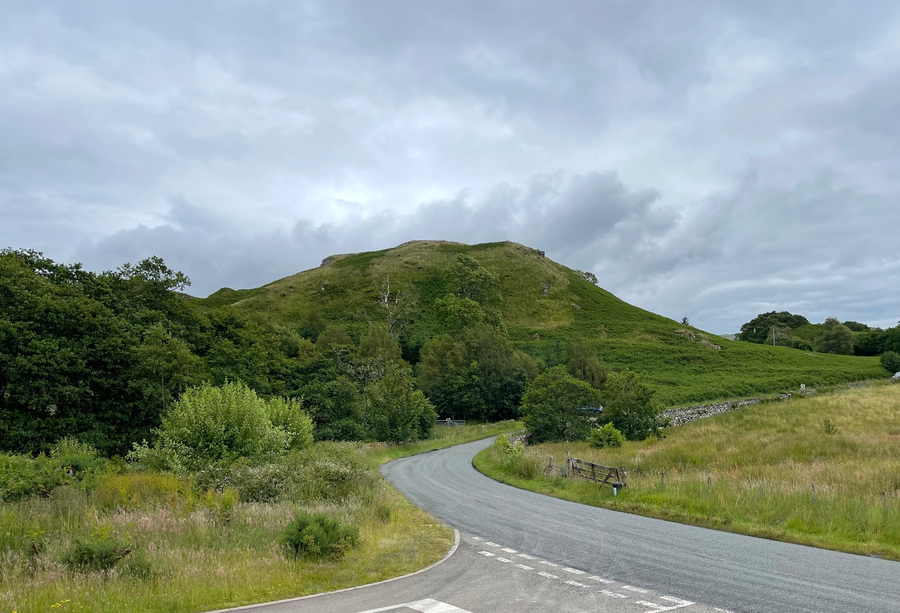
From the famous Dick Hudson’s pub on the south side of Ilkley Moor, take the road right (east) for a half-mile until you reach the large Weecher Reservoir just off the roadside on your right.  Less than 300 yards past the reservoir, a footpath takes you onto the moor itself.  Walk up the path for about ⅔-mile — crossing one wall, then walking roughly parallel with another on your right — until you reach a crossing of paths where there are 2 gates or stiles.  Take the lower of the two stiles, through the wall, but below the fence.  You’ll see an awful Yorkshire Water cover, which has just about destroyed the once-fine well that had always flowed here.  Below this, by the wallside, are the trickling remains of our old healing spring.

Archaeology & History

When I was a young boy, Horncliffe Well was the site we would visit every weekend as our first stopping-spot on our regular ventures exploring these moorlands — “from Wrose to Rombalds,” as we use to call it!  The old well was always very plentiful, strong-flowing, cold and truly refreshing.  It was undoubtedly the best water source on the entire Rombalds Moor region, never drying up.  Even in the great droughts of 1976 and 1995, after all others had just about failed, the waters at Horncliffe were still flowing as strong as ever, as they had always done.  But not anymore…

Edna Whelan’s old drawing

First described in land records of 1273 CE, this has always been a well of great repute and oral tradition told that this great old well never ran dry. It marked the ancient boundary point where the moorlands of Hawksworth, Burley and Bingley all meet.  By name alone it is associated with the nearby and curious Horncliffe Circle, whose status itself is unclear (the circle seems more a place of refuge or living than a true ritual site).

Horncliffe House around 1801

The remains of old buildings on the flat just above where the waters once flowed were built in much more recent centuries.  The building appears to have been started around 1799, for E.E. Dodds (1985) told that in 1800 it was used as a school for several years by local teacher Joshua Briggs.  J. Horsfall Turner (1907) published a copy of an old drawing of the school, as it was soon after construction.

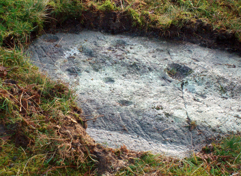
Horncliffe Well was dug into by the privatized water company known as Yorkshire Water (owned by rich greedy fuckers) in the 1990s, who channelled most of its endless supply away for commercial benefit.  When their company was stealing the water from the moors, the workmen snapped an old markstone at its base next to the adjacent Horncliffe House (in ruins).  The waters had always flowed fast and freely, but after Yorkshire Water had finished their ‘work’ here, the great majority of Horncliffe’s water supply subsided considerably, leaving walkers, birds and animals to suffer from its demise.  In all sincerity, it’s to be hoped that good people someday will visit this once-fine site and return it to its previous healthy status.

Folklore

When we were kids we came here every weekend and got to know the old ranger who we’d meet either here or at the adjacent Horncliffe Circle, 250 yards NNE, where we’d sit and eat.  In the mid-1970s, he told us that the old well was once a site where the fairy-folk would play, around Mayday (beltane).  And though in later years I’ve sought for any information about this in all early antiquarian books that cover this area, I’ve never found any mention of this tale in print.  The old ranger knew the moors and its history better than anyone I’ve ever known and many old stories died with him after his death.

References:

  1. Bennett, Paul, The Old Stones of Elmet, Capall Bann: Chieveley 2003.
  2. Dodd, E.E., Bingley: A Yorkshire Town through Nine Centuries, M.T.D. Rigg: Guiseley 1985.
  3. Laurence, Alastair, A History of Menston and Hawksworth, Smith Settle: Otley 1991.
  4. Turner, J. Horsfall, Idle Upper Chapel Burial Registers and Graveyard Inscriptions, Harrison & Son: Bingley 1907.
  5. Whelan, Edna, The Magic and Mystery of Holy Wells, Capall Bann: Chieveley 2001.
  6. Whelan, Edna & Taylor, Ian, Yorkshire Holy Wells and Sacred Springs, Northern Lights: Dunnington 1989.

© Paul Bennett, The Northern Antiquarian


Knock Hill, Dunblane, Stirlingshire

Hillfort:  OS Grid Reference – NS 7825 9845

Also Known as:

  1. Canmore ID 45987
  2. Gallow Hill

Getting Here

The snow-covered old fort

You can come here from either Dunblane to the north, or Bridge of Allan immediately south: either way you reach the site by going along the A9 road until you reach the Lecropt Church, a half-mile north of Bridge of Allan.  On the other side of the road is a somewhat battered wooden gate.  Go through here and up towards the tree-covered hill, following its edges to the right for a few hundred yards, until you come to another very large mound covered in trees.  That’s what you’re looking for!

Archaeology & History

Described on early OS-maps as a “Supposed Roman Camp,” this large fortified stone hillock has more recently been considered a creation of indigenous Scots.  Hemmed in and hidden on most sides, by the rises of Knock Hill to the west and Gallows Hill to the east, the only lines of visibility out of the fortress is along a northwest to southeast corridor, keeping the site quite secret to outsiders.  It would have been a fine place for a small community in ages not-so-long-ago, keeping the people hidden from the pestilent invasions of both Romans and english in bygone times.

The tree-clad fort, through blizzard

The large raised oval enclosure was walled around its sloping sides and edges, with remains of a walled embankment still visible running around the top of the slopes.  What may have been traces of hut circles were on top of the hillock until recent times, but these have been much reduced by some digging near the middle of the site.  It would appear that an ‘entrance’ was once visible on the southeastern side of the fort, but when we came here the other day, a lovely blizzard covered the place in snow, so this was difficult to see.

When the Royal Commission chaps came to visit the place in 1979, they didn’t really say much about the place, merely telling of its dimensions, saying:

“This fort measures 48m by 32m within the remains of a single rampart 4.5m thick and 1m high.”

I’m sure there must be much to be said of this lovely old site by local antiquarians, but I haven’t found much as yet.  But if you’re wanting a nice quiet spot to sit for a while on the outskirts of Stirling and Dunblane, I’d heartily recommend visiting this place.  Badgers and deer also seem to like the place!

References:

  1. Royal Commission on the Ancient & Historical Monuments of Scotland, Archaeological Sites and Monuments of Stirling District, Central Region, Society of Antiquaries of Scotland 1979.

© Paul Bennett, The Northern Antiquarian 


Corrycharmaig (4), Glen Lochay, Killin, Perthshire

Cup-Marked Stone:  OS Grid Reference – NN 52768 35504

Getting Here

‘Corrycharmaig 4’ cup-marked stone

Follow the same directions to get to the Corrycharmaig 3 carving; and just a yard or two to the right of the far western edge of the rock, you’ll see another smaller slightly sloping rock, closer to the fencing, with faint cup-markings.  That’s the one! (note that the 10-figure grid reference given here might need adjusting slightly)

Archaeology & History

This small slightly sloping piece of exposed rock is on the western extremity of the Corrycharmaig cluster of carvings, but is a distinctly separate piece of rock from the Corrycharmaig 3 stone (though part of the same outcrop).  The stone itself has two sections to it, with a natural crack in the rock defining eastern and western section — both of which possess cup-marks.

The easternmost section of the stone has seven cup-marks, some of which were only recently uncovered.  A large single cup-mark sits near the middle of this portion of the rock; this is probably what Mr Cormack (1952) was talking about when he told that, “further west (of the Corrycharmaig 3 carving, PB) is one isolated larger cup of 4-inch diameter.”  On the western side of the stone, we find just two or three cup-marks, though one large cup-marking here would seem to be Nature’s handiwork.

It is highly likely that beneath the excessive vegetational growth around this carving and others along this ridge, other sections of prehistoric carvings remain to be found.

References:

  1. Cormack, E.A., “Cross-Markings and Cup-Markings at Duncroisk, Glen Lochay,” in Proceedings of the Society of Antiquaries, Scotland, volume 84, 1952.
  2. Morris, Ronald W.B., The Prehistoric Rock Art of Southern Scotland, BAR 86: Oxford 1981.
  3. Royal Commission on the Ancient & Historical Monuments of Scotland, Archaeological Sites and Monuments of Stirling District, Central Region, Society of Antiquaries of Scotland 1979.

© Paul Bennnett, The Northern Antiquarian


Samson Stone, Callander, Perthshire

Legendary Rock:  OS Grid Reference – NN 60399 07820

Also Known as:

  1. Samson’s Putting Stone

Getting Here

Samson Stone on Bochastle Hill

Go west out of Callander on the A84 road and after a mile or so turn left at Kilmahog, down the A821.  After a few hundred yards, past the parking spot by the roadside, look up the small Bochastle Hill on your right and you’ll see a large singular boulder resting on top.  That’s it!

Archaeology & History

When I first wandered up to this giant rock, I was hoping there may have been cup-markings on its surface, but none could be found.  The stone is a glacial erratic.  The Iron Age hillfort of Dunmore is 370 yards (338m) to the southwest.

Folklore

Samson Stone, close-up

In Mr Rogers’ (1853) fine historical tour of the region, he notes the Samson Stone “on the summit of one of the eminences of Bochastle,” a couple of miles west of Callander, but wondered “how it came to occupy this remarkable position.”  If he’d have asked some of the old locals they may have told him what Rennie McOwan (1996) came across and described in his excellent work on the folklore of Scottish mountains.  For the Samson Stone was traditionally thrown here by one of the Fingalian giants in ancient times.  It was originally located upon Ben Ledi, nearly 3 miles northwest, and was one of several stones being thrown in a competition to see who was the strongest of the giants — and Samson was the name of the one who threw this huge rock.  Another version of the same legend tells that the stone was originally thrown from Ben Lawers, 21 miles (34km) to the north.

References:

  1. Bain, William, Around and about Callander, Callander & District Round Table n.d. (c.1978).
  2. McOwan, Rennie, Magic Mountains, Mainstream: Edinburgh 1996.
  3. Roger, Charles, A Week at Bridge of Allan, Adam & Charles Black: Edinburgh 1853.

© Paul Bennett, The Northern Antiquarian


West Woods 01, Calverley, Leeds, West Yorkshire

Cup-Marked Stone:  OS Grid Reference – SE 1970 3731

Getting Here

On the A657 road, a half-mile past Greengates towards Calverley, just before the road starts going uphill, take the lower dirt-track of Eleanor Drive on your left into Calverley Woods (here known as West Woods).  About 150 yards along the track, note the small footpath on the right which goes up diagonally further into the trees.  Go along here until you reach the remains of a dried-up pond on your left.  The carved stone is about 10 yards before the pond, just above the footpath.

Archaeology & History

Rubbing of the 2 cupmarks

Another stone only for the puritans amongst you!  This (and the West Woods 2 carving) was one we found in 1985 when we were exploring the woods looking for the Calverley Woods cup-marked stone reported by Sid Jackson in the 1950s.  The stone is a small roughly oblong, earthfast rock, about 2ft by 1ft across, and has two distinct but faded cup-marks on its slightly sloping face. That’s it!

Soon after first finding this, we made a couple or rubbings of the stone, one of which I reproduce here and which shows the two cup-marks.  You’ll note the measurement and note of the cups being 2 megalithic inches (MI) in diameter.  The MI was a statistical unit of measure suggested by the late great Alexander Thom, who found regular integers of 2.07cm in many of the cup-and-rings he examined, and so surmised it as a deliberate numeric system.  At the time when we found this cup-marked stone, I was exploring Thom’s idea and was very much taken up with it.  However, after a few years doings numerous rubbings of the many cup-and-ring stones in West Yorkshire, and exploring the simple size of the human hand and how we execute cup-markings on rocks, I found Thom’s idea didn’t seem to be realistic. (though I still love Thom’s works: the man was an outstanding researcher, far exceeding all the archaeologists of his period in terms of his exploratory methods)

References:

  1. Bennett, Paul, “The Undiscovered Old Stones of Calverley Woods,” in Earth 2, 1986.

© Paul Bennett, The Northern Antiquarian


Nottingham Hill Carving, Gotherington, Gloucestershire

Cup-and-Ring Stone:  OS Grid Reference – SO 9875 2825

Archaeology & History

Nottingham Hill cup-and-ring

A rare find this!  In October 1981, in deepest Gloucestershire on the edge of the Nottingham Hill Iron Age hillfort, archaeologists sifting through what they ostensibly called “occupational debris” along the western edge of the huge enclosed monument, found a singular piece of local oolitic limestone etched with an archetypal cup-and-ring design!  The carving was on a typical ‘portable’ piece of stone and would not have been amiss had it been uncovered in a neolithic or Bronze Age cairn in our more northern climes.  But this southern example is something of an anomaly.

In Morris & Marshall’s (1983) description of the stone they told how,

“it was found as a loose block lying with the worked surface uppermost, and half-embedded in the plough-soil, together with other slabs and irregular lumps of oolitic limestone of similar size, and of closely related rock-type.  The object is a discreet slab with an unworked under-surface weathered by percolation of ground-water along a joint.”

Drawing of the carving

They found that the carved stone was typical of other rocks making up the ramparts at the outer-edges of the hillfort, and at some point in its history may possibly having been included in the walled structures of the fortress itself.  However, this is unlikely to have been the original use of the carving.  Its inclusion in the Iron Age ramparts would more be a likely consequence of it being appropriated from another, much earlier archaeological site in the area — a chambered tomb or long barrow for example.  This re-use of cup-marked stones in the Cotswolds is known to have occurred in the village of Salford, on the church cross-base, 18.75 miles (30.2km) east of here.

The Nottingham Hill cup-and-ring was described in some detail by Morris & Marshall (1983).  The rock on which it was carved measured one square-foot in size and barely 3 inches thick.  The central cup-mark measured,

“approximately 15.5cm in diameter, and a shallow radial groove (channel 1) leads from it to the edge of the stone.  The central cup-mark is surrounded close to its lip by a penannular channel or ‘ring’ (channel 2), which has a small depression at one end.  This end of channel 2 appears to be discontinuous with channel 1, but there is a very lightly pecked connection at the other end.  Outside channel 2 is a second shallower ring or channel (channel 3) but because of its shallowness it is difficult to determine whether it links with the radial channel 1.  Channel 3 contains a clear, small cup-mark part-way along its length, and is quite definite on one side of the central cup-mark, and on the other side it is possibly mirrored by a rather indistinct depression or cup-mark and length of channel.  Channel 3 is not continuous throughout its length, ending where it meets the edge of the stone beyond the small cup-marks.”

It is obvious that the carving, whenever it was made, was not subjected to long-term exposure to the outside air, as the carved design would have eroded quite quickly on the oolitic limestone.

References:

  1. Morris, Ronald W.B. & Marshall, Alistair, “A Cup and Ring Marked Stone from Nottingham Hill, Gotherington,” in Bristol & Gloucestershire Archaeological Society Transactions, volume 101, 1983.
  2. Royal Commission on Historical Monuments, England, Ancient and Historical Monuments in the County of Gloucester: Volume 1 – Iron Age and Romano-British Monuments in the Gloucestershire Cotswolds, HMSO: London 1976.

© Paul Bennett, The Northern Antiquarian


Tarry Stone, Cookham, Berkshire

Legendary Stone:  OS Grid Reference – SU 89745 85392

Also Known as:

  1. Cookham Stone
  2. Tarrystone

Getting Here

Old postcard of the Tarry Stone

Dead easy!  Just about in the middle of the village, by the side of the road where a seat allows the weary walker a chance to sit and rest, the Tarry Stone stands before it, with a plaque on the wall above the seat.  The old postcard here shows its situation clear enough!

Archaeology & History

The history of this large rock near the middle of Cookham village is important in the history of the old village, though there is no direct evidence to give it a prehistoric pedigree.  It was known to be an ancient boundary stone and is included in perambulation records of the area, where local people would annually walk and redefine the landscape of Cookham: a pastime known across the land, but which fell into disuse in Victorian times.  Such perambulations are thought to trace way back into the mythic lands of prehistory — so the Tarry Stone here may well have an archaic provenance.

The known history of the stone was gathered and described in Stephen Darby’s (1899) rare work on the place-name history of Cookham.  He wrote:

“A stone 3½ ft high, by 4 ft long, and 2½ ft thick. This formerly stood in Cookham village, about two feet from Dodson’s fence, where the roads parted to the church and the ferry. It is now in the Mill Garden at Cookham, where it was removed by the late George Venables when he was church-warden. This stone was formerly known as Cookham Stone.

“A.D. 1506: The tithing man presents that the Warrener ought to hold sports at Cookham Stone on the day of Assumption; and he has not done so (Cookham Manor Court Rolls).

“The stone was originally a boundary stone to the property of the Abbot of Cirencester, whose house was close by, as is shown in the will of John Luffenham, A.D. 1423.”

An old plaque that was once attached to the rock told, “The Tarry Stone at which sports were held before 1507 AD, stood formerly 50 yards NNE and was replaced here AD 1909 by order of the parish council.”  The position described “50 yards away” was next to an old pub with the fascinating legendary name of ‘Bel and the Old Dragon’!

Folklore

Dennis Curran’s 1976 drawing

One of the main reasons this site has been included here is the legendary attachments.  When the stone was moved from its original position in 1839 by a certain George Venables, to nearby Mill House Gardens, local people told how the Venable family thereafter were cursed.  It was thereafter moved back to its earlier site!

The stone has been suggested as a meteorite — a theme that was echoed in Peter Ackroyd’s Thames (2007), but the Tarry Stone is a regional sarsen rock, albeit peppered with erosion holes, giving a more ‘foreign’ look to it!

Cookham was also the village where the spirit of the god Herne “winds his horn and the music of his hounds can be heard from across the common.”  (Yarrow 1974)  The stone was also the focal point of village games in earlier centuries.

References:

  1. Ackroyd, Peter, The Thames: Sacred River, Chatto & Windus: London 2007.
  2. Darby, Stephen, Place and Field-Names of Cookham, Berkshire, privately printed: London 1899.
  3. Hallam, Elizabeth, Domesday Heritage, Arrow: London 1986.
  4. Yarrow, Ian, Berkshire, Hale: London 1974.

© Paul Bennett, The Northern Antiquarian


Rhiwderin, Newport, Monmouthshire

Cup-Marked Stone (lost):  OS Grid Reference – ST 260 870

Archaeology & History

Rhiwderin cup-marks

This fine-looking cup-marked stone was uncovered during a botanical outing in the last decade of the 19th century.  Described as being around the township of Rhiwderin, the exact whereabouts of the carving is unknown and it’s not been seen since the first description of it in an early edition of Archaeologia Cambrensis by Mr T.H. Thomas. (1895)  John Sharkey (2004) mentioned the site in his recent survey of Welsh rock art, saying simply “location unknown.”

The missing Rhiwderin stone

Although we know there are no hard and fast rules for working out the location of cup-and-ring markings, one may be fortuitous in exploring any nearby Bronze Age or neolithic tombs (cairns, tumuli, etc) in the Rhiwderin district, as they do tend to enjoy the company of such sites — but I must stress, this is by no means a dead cert!

Mr Thomas’s description of the carving was as follows:

“I enclose a sketch of what seems to be a cup-marked stone which I observed yesterday near Rhiwderin, Monmouth.  Unless there be some operation which simulates such markings with which I am unacquainted, I take the specimen to add an instance of these mysterious prehistoric remains to the very short list given for Wales by Mr. Romilly Allen, and to be the first reported for South Wales.

“The stone displaying the cup-markings is a mass of millstone grit, earth-fast, the slanting surface appearing above the turf being about a yard wide, and 4 feet long.  Upon the upper half of the surface is a group of twelve cups from 1½ to 2in diameter, and about 1in deep. On first noticing the cups they were taken for holes out of which quartz pebbles, abundant in the local millstone grit, had been weathered, but examination of the block showed that no pebbles of large size exist, or had existed in it, and the conclusion was arrived at that the cups are artificial.

“On turning back some of the turf covering the base of the slope of the stone, no other cups were discovered.

“The stone lies within an old enclosure, as shown by wild apple-trees and an abundance of daffodils, and still more clearly by ruins, which seem those of a cottage or small farm near by. This contiguity to a habitation which does not seem to have been abandoned more than a century, made me suspect some medieval or more recent origin for the markings. I cannot, however, account for them otherwise than by supposing them to be cup-markings in the technical archaeological sense.

“The stone was observed while in the company of Dr C.T. Vachell of Cardiff, searching for varieties of narcissus which occur at several points in the neighbourhood…”

If anyone comes across this lost carving, please let us know!

References:

  1. Sharkey, John, The Meeting of the Tracks: Rock Art in Ancient Wales, Gwasg Carreg Gwalch: Llanrwst 2004.
  2. Thomas, T.H., ‘Archaeological Notes and Queries,’ in Archaeologia Cambrensis, volume 12 (5th series), 1895.

© Paul Bennett, The Northern Antiquarian 


Dun Toiseach, Ford, Kilmartin, Argyll

Dun:  OS Grid Reference – NM 8808 0476

Getting Here

The hill of Dun Toiseach

You can see the rocky hillock ‘pon which this old dun sits from the roadside – and can approach it by either climbing up the slope, or go round t’ back and approach it from t’ track. Either way, it’s easy to get to.

Archaeology & History

This old dun was rather ramshackled when I used to sit here, sometimes on my way home from working at the Inverliever Nursery, a bit further up the lochside — but it was a good spot to sit and daydream into Loch Awe and beyond…

Described as a vitrified fort, the structure is oval in shape.  Thought to have been constructed in the Iron Age, Dun Toiseach was originally about 50 feet across and its walls averaged 10 feet thick, with an entrance at its northeastern side.  The Royal Commission lads (1988) described it thus:

Dun Toiseach plan (after RCAHMS 1988)

“Situated on a prominent rocky knoll overlooking the S end of Loch Awe 250m ESE of Torran farmsteading, there is a severely ruined dun measuring about 16m by 13m within a wall which has been some 4m thick. Two stretches of outer facing-stones are visible, as well as a few possible stones of the inner face, but, particularly on the NE, the wall has been severely robbed and the core material scattered. The entrance lies on the NE, the innermost portion of the SE passage-wall and what may be a door-jamb on the opposite side still being visible.  The knoll has acted as a focus for recent field-walls, but there is no indication that it was additionally defended by outworks. A small modern cairn…surmounts the dun wall on the SE.”

References:

  1. Royal Commission on the Ancient & Historical Monuments of Scotland, Argyll – Volume 6: Mid-Argyll and Cowal, HMSO: Edinburgh 1988.

© Paul Bennett, The Northern Antiquarian


New Edge Chalybeate, Colden, Heptonstall, West Yorkshire

Healing Well:  OS Grid Reference – SD 95447 29403

Getting Here

Take the Heptonstall road up from Hebden Bridge, going round the village (not into it) and head through Slack and onto Colden.  Just as the road begins to go downhill to Colden, note the small single-track road on your right called Edge Road.  Go on here for a good mile until it becomes a dirt-track and there, on your left, is the half-run-down old farmhouse called New Edge.  Just yards past it, off to the right by the trackside, you’ll see this large copper-coloured stone basin oozing with the same-coloured liquid.

Archaeology & History

New Edge Chalybeate, above Colden

This is one of what Thomas Short (1724) called “the ten thousand chalybeats”, or iron-bearing springs,  inhabiting the Yorkshire uplands — but he didn’t include this site in his huge survey.  But it’s a beauty amongst chalybeates, as a visit here clearly shows!  The well is one of two found on either side of the old building known as New Edge (as contrasted with Old Edge, a little further along the lane), and its waters trickle gently from the old stone trough.

The waters are undoubtedly enriched with large amounts of iron, as the photo here shows, giving the waters clear medicinal value.  In tasting them, not only do the waters give you that copper-coloured hue, but you can clearly taste the minerals in the water. As with other iron-bearing springs, the water from the New Edge spring is good for the blood, good for anæmia, loss of energy and a low immune system.

References:

  1. Short, Thomas, The Natural, Experimental and Medicinal History of the Mineral Waters of Derbyshire, Lincolnshire and Yorkshire, privately printed: London 1734.

© Paul Bennett, The Northern Antiquarian