Witches’ Stone, Ratho, Midlothian

Cup-Marked Stone (destroyed):  OS Grid Reference – NT 1273 6973

Witches Stone on 1817 map

Also Known as:

  1. Canmore ID 50366
  2. Witch’s Stone

Archaeology & History

This fascinating looking carving (in my personal Top 10 of all-time favourites cup-and-rings in the UK!) was unfortunately destroyed sometime between 1918 and 1920.  A huge pity, as the design on the rock is almost unique in its ‘linear’ system of cups running a considerable length across the surface of the stone (like the similar design found at Old Bewick in Northumberland).

Wilson’s 1851 drawing of the Witches’ Stone
Simpson’s 1866 drawing of the Witches Stone

Shown first of all on Kirkwood’s Environs of Edinburgh map in 1817 (above), this legendary rock was found amidst a cluster of other cup-and-ring stones at Tormain (some are still there) and was initially said by Daniel Wilson (1851) to have been the giant capstone of a cromlech that once stood here, but whose structure had fallen away.  This idea is implied in the earliest drawing we have of the stone in Wilson’s magnum opus (above); Sir J.Y. Simpson (1867) gave us a similar impression with his drawing a few years later.  But upon visiting the Witches Stone just as his book was going to the press, Mr Wilson visited the site and proclaimed that he “altogether doubted if they are the remains of a cromlech”, and what rested here were more probably just fascinating geological remains, with even more fascinating carvings on top!

In the years that followed Wilson’s initial description, the Witches Stone was visited and described by a number of eager antiquarians.  Simpson (1867) gave us a quite revealing account, telling:

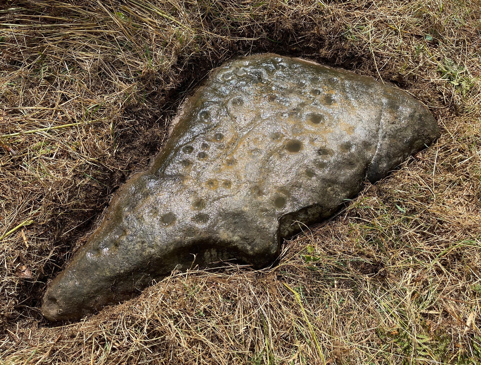
“On the farm of Bonnington, about a mile beyond the village of Ratho…are the remains of ‘this partially ruined cromlech’…with the capstones partially displaced, as if it had slid backwards upon the oblique plane of the huge stones or stone which still supports it.  Two or three large blocks lie in front of the present props.  Its site occupies a most commanding view of the valley of the Almond, and of the country and hills beyond.  The large capstone is a block of secondary basalt or whinstone, about twelve feet long, ten in breadth and two in thickness.  Its upper surface has sculptured along its median line a long row of some twenty-two cup-cuttings; and two more cup-cuttings are placed laterally: one, half a foot to the left of the central row and at its base; the other, two feet to the right of the tenth central cup and near the edge of the block. The largest of the cups are about three inches in diameter and half an inch in depth; but most of them are smaller and shallower than this…”

A few years later another early petroglyph authority, J. Romilly Allen (1882), visited the Witches Stone and found “an Ordnance bench mark (had been) cut on the stone itself”!  He then continued with his own description of this once-important megalithic site:

“The Witch’s Stone is a natural boulder of whinstone, rounded and smoothed by glacial action, whoso upper surface slopes at an angle of about 35° with the horizon. The length of the sloping face is 8 feet and at the top is a flat place 2 feet wide. The breadth of the stone is 11 feet 3 inches at the upper end, and 4 feet at the lower end. The thickness varies from 2 to 3 feet. The highest part of the stone is 6 feet 6 inches above the ground, and the lowest 1 foot 6 inches. It rests on what has originally been a portion of the same boulder, but is now a mass of whinstone broken up into several fragments, which serve as supports to prop up the stone above.  Viewed from the north side the whole presents the appearance of a cromlech, the upper stone forming the cap, and the disintegrated portion below the supports. This notion, however, will be clearly seen to be erroneous on looking at it from the opposite side, as shown on the accompanying sketch…where the crack separating the two portions of the boulder is very apparent… The sculpturings consist of twenty-four cups varying in diameter from 1½ to 3 inches. Twenty-two of these cups are arranged in an approximately straight line along the sloping face of the stone, and divide it into two almost equal parts. The two remaining cups lie, one 7½ inches to the left of the lowest cup of the central row, and the other 2 feet 3 inches to the right of the ninth cup up the stone… The field in which the Witch’s Stone is situated is called “Knock-about.” The sloping face of the stone has been much polished by the practice of people climbing on to the top and sliding down. Some of the cups are almost obliterated in consequence. The stone forms a very prominent feature in the view, and must always have attracted attention from its peculiar shape.”

Some twenty years after Allen, the megalithomaniac Fred Coles (1903) came and checked the Witches Stone out for himself and, as happens, had a few additional things to say about the place:

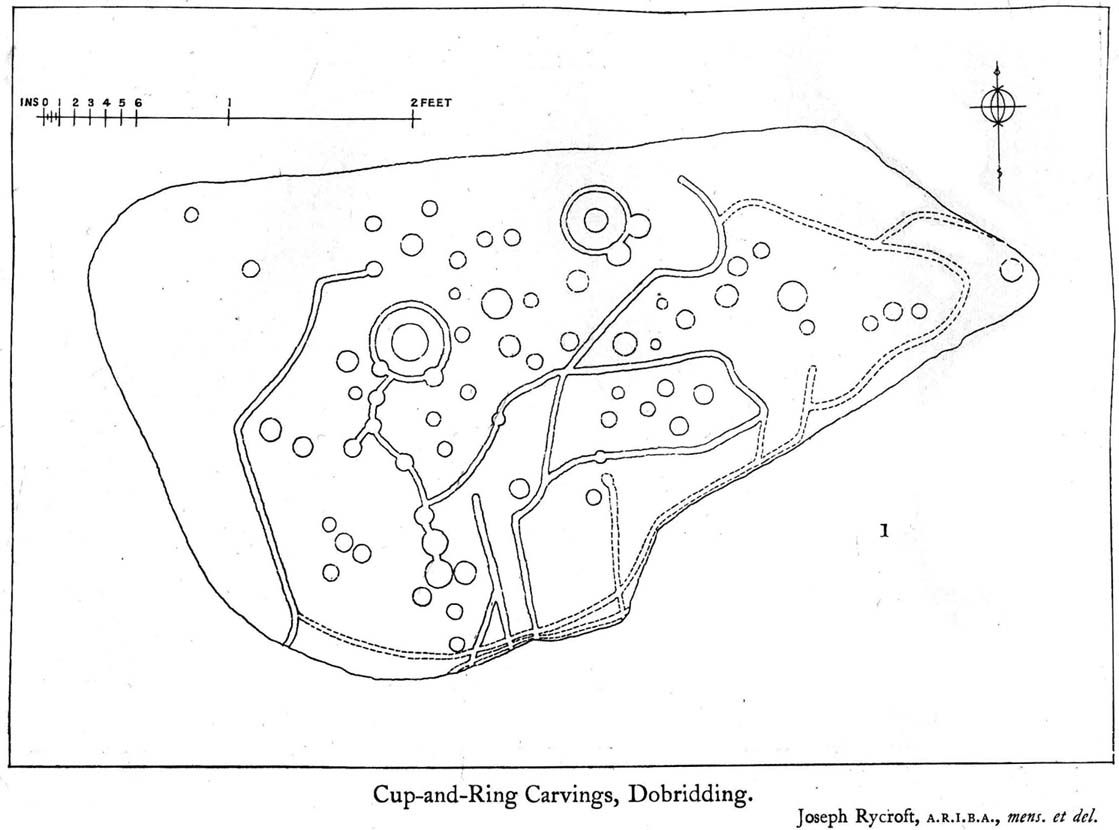
“Although this huge boulder and its cup-marks have been more than once figured and described, I found, on a close examination of the broad surface of the Stone, that none of the illustrations showed the cup-marks in their exact relation to each other, nor in their true relation to the contour of the Stone. The drawing shown above…was made after a careful measurement by triangulation of the Stone; and it is claimed to be the first that shows that the cups, two and twenty in number, are not disposed in one continuous line, but that thirteen follow each other from the high south edge of the stone for a distance of exactly 6 feet, and nine others lie a few inches to the west, occupying a space 3 feet long of the overcurving edge of the north end.  It is further shown that, at a point 2 feet 3 inches west of the ninth cup-mark, there is another one quite as large as the largest in the rows near the middle of the Stone. The south edge (A B) has slipped a little down from its original height, the boulder being frost-split horizontally; its height there above ground is 8 feet. The northern and narrower end is about 2 feet above ground, and does not touch the ground, as it rests upon its lower portion, beyond which it projects a few inches. The cup-marks run due north.”

Fred Coles 1903 drawing

If the Witches Stone was in fact a natural outcrop stone and not a cromlech, this very last point telling that “the cup-marks run due north” probably had much greater importance than a mere compass-bearing to the people who etched this carving.  For in pre-christian religious structures across the northern hemisphere, north is commonly representative of death and the land of the gods.  In magickal rites “it is the place of greatest symbolic darkness,” as neither sun nor moon ever rise or set there.  Additionally, north is the place where, in shamanic traditions, the heavens are tied to the Earth: the cosmic axis itself that links heaven, Earth and underworld.  In early neolithic traditions this mythic structure was probably endemic. Whether its magickal relevance was intended here, at this stone, we will probably never know…

Folklore

Folklore tells that the Witches Stone was one of the sites used in magickal rites by the Scottish occultist, Michael Scot.  J.R. Allen’s (1882) description of “the sloping face of the stone has been much polished by the practice of people climbing on to the top and sliding down,” may relate to folk memory of fertility rites once practiced here, as found at similarly carved rocks in the UK and across the world.

References:

  1. Allen, J. Romilly, “Notes on some Undescribed Stones with Cup Markings in Scotland,” in Proceedings of the Society of Antiquaries Scotland, volume 16, 1882.
  2. Coles, Fred R., “Notes on Some Hitherto Undescribed Cup-and-Ring Marked Stones,” in Proceedings of the Society of Antiquaries Scotland, volume 37, 1903.
  3. McLean, Adam, The Standing Stones of the Lothians, Megalithic Research Publications: Edinburgh no date (c.1978).
  4. Morris, Ronald W.B., The Prehistoric Rock Art of Southern Scotland, BAR: Oxford 1981.
  5. Royal Commission on the Ancient & Historical Monuments of Scotland, Inventory of Monuments and Constructions in the Counties of Midlothian and West Lothian, HMSO: Edinburgh 1929.
  6. Simpson, James, Archaic Sculpturings of Cups, Circles, etc., Upon Stones and Rocks in Scotland, England and other Countries, Edmonston & Douglas: Edinburgh 1867.
  7. Smith, John Alexander, “Notes of Rock Sculpturings of Cups and Concentric Rings, and ‘The Witch’s Stone’ on Tormain Hill; also of some Early Remains on the Kaimes Hill, near Ratho, Edinburghshire,” in Proceedings of the Society of Antiquaries Scotland, volume 10, 1874.
  8. Wilson, Daniel, The Archaeology and Prehistoric Annals of Scotland, Sutherland & Knox: Edinburgh 1851.

© Paul Bennett, The Northern Antiquarian


Crook Farm (north), Baildon Moor, West Yorkshire

Cup-and-Ring Stone:  OS Grid Reference – SE 13703 39616

Getting Here

Crook Farm North CnR

Take the road up alongside and past Shipley Glen, taking the turn to go to Crook Farm caravan site. Go right to the very end of the car-park, then walk up the footpath through the trees on your left.  Keep going uphill about 100 yards by the field-wall until the land begins to level out – and shortly before the first gate into the field (on your right) keep your eyes peeled for the triangular stone in the ground, barely 10 yards away from the walling.  Alternatively, from the entrance into the Dobrudden caravan park walk to the far-end of the level area in front of the little cafe and walk along the footpath that crosses the grassland to the walling nearly 300 yards away (south).  Follow the wall down below the gate and zigzag about. You’re damn close!

Archaeology & History

Crook Farm north carving

For some reason this has always been one of my favourite cup-and-ring stones on Baildon Moor and it’s well worth checking out if you visit the area!  It was rediscovered by the Bradford historian W.E. Preston, who photographed the carving around 1912.  Shortly afterwards he took fellow historians Joseph Rycroft and W. Paley Baildon to see this (and others he’d located) and subsequently both a drawing and Mr Preston’s photo of the site was included in Mr Baildon’s (1913) magnum opus the following year.

As you can see from the relative photos—with literally 100 years between them—erosion hasn’t taken too much toll and this neolithic or Bronze Age carving remains in very good condition.

Rycroft’s early drawing
Preston’s 1912 photo

Covered with upwards of fifty cup-markings, there are also two cup-and-rings and numerous carved lines meandering around and enclosing some of the many cups.  One cup-mark was cut into the narrow end or ‘nose’ of the stone.

It’s a fascinating design, with another ‘Cassiopeia’ cluster of cups in one section, beloved of archaeoastronomers who explore these stones.  Mr Rycroft’s drawing of the design (left) is perhaps the best one, to date.

Along this same ridge there are remains of other prehistoric sites, more cup-and-rings, remains of prehistoric walling and what may be a small cairn circle (to be described later).

References:

  1. Baildon, W. Paley, Baildon and the Baildons – parts 1-15, Adelphi: London 1913-1926.
  2. Bennett, Paul, Of Cups and Rings and Things, unpublished: Shipley 1981.
  3. Bennett, Paul, Megalithic Ramblings between Ilkley and Baildon, unpublished: Shipley 1982.

© Paul Bennett, The Northern Antiquarian


Baildon Moor Carving (150), West Yorkshire

Cup-and-Ring Stone:  OS Grid Reference – SE 13724 40096

Also Known as:

  1. Carving no.22 (Hedges)

Getting Here

CR-150; Dobrudden Stone to rear

Whether you come via Shipley Glen or Baildon, head for the Dobrudden caravan park on the western edge of Baildon Hill.  As you get to the entrance of the caravan site, turn right and walk along the outer walling of the caravan site, up and around for less than 100 yards.  Keep your eyes peeled for the upright stone against the outer walling (the famous Dobrudden Cup-and-Ring Stone), and just 10 yards away, laid flat in the grasses, you’ll see this small cup-and-ring stone!

Archaeology & History

Found just a few yards from the well-known Dobrudden Carving that stands up against the wall, this small flat level stone, slowly again being encroached by Earth’s skin, is found on the edge of the High Plain, whereon the usual conjunction of prehistoric tombs and cup-and-rings is found once again.  Whether this carving ever had its own cairn or funerary monument is now hard to say for sure; and the excessive erosion of modern humans is slowly eradicating the landscape all round here.

Jackson’s 1956 drawing
Hedges 1986 drawing

Consisting of two cup-and-rings (with very deep cupmarks in the centres), there are also what seem like artificially carved lines or grooves running across the stone.  It was first described in a short article in the Cartwright Hall Archaeology Group Bulletin (Jackson 1956)*, found lying “in the path alongside the north wall of the Dobrudden Farm enclosure.”  It seems like stone may have been covered over until some local work on Dobrudden unearthed it in the latter half of the 20th century.  There’s also an intriguing note told by a local man called Jack Taylor, which Jackson narrated, saying how he,

“always held the opinion that the rings were not contemporary with the cups, and went so far as to suggest that they had been carved within living memory by someone anxious to ‘improve’ the boulder.”

This might be the case, as there is another carving not far away near the top of Baildon Hill that certainly seems to have been done in the 20th century.  And one of the two surrounding rings on this stone does appear to have a more recent look to it than the other.  However, we must consider that the covering soil has kept the carved rings in such good condition. (There are examples of petroglyphs throughout the world where certain carved elements were added at later times by countless aboriginal tribes.)

Close-up of cup-&-rings
Dobrudden carving 150

Like all of these carvings, to get an accurate picture of the true original we must visit them in all weathers all through the year, to see how differing seasons express the petroglyph. For we can see on some images we have of this carving a number of features that aren’t on the drawings of either Jackson (1956) or Hedges (1986): whether the rings surrounding the cups are ancient or not, there is a definite carved line nearly linking them together; and at least one faint line stretches down from one of the rings.  We need to visit the carving again to see if such features show up with greater clarity when lighting conditions are better.

References:

  1. Baildon, W. Paley, Baildon and the Baildons – parts 1-15, Adelphi: London 1913-1926.
  2. Bennett, Paul, Megalithic Ramblings between Ilkley and Baildon, unpublished: Shipley 1982.
  3. Boughey, Keith & Vickerman, E.A., Prehistoric Rock Art of the West Riding, WYAS: Leeds 2003.
  4. Hedges, John, The Carved Rocks on Rombald’s Moor, WYMCC: Wakefield 1986.
  5. Jackson, Sidney, “Another Cup-and-Ring Boulder,” in Bradford Cartwright Hall Archaeology Group Bulletin, 1:13, 1956.

* Boughey & Vickerman (2003) cited W. P. Baildon’s magnum opus (1913) as the first to describe this stone, but this is untrue (there’s certainly no mention nor illustration of it in my editions of the Baildon volumes).

© Paul Bennett, The Northern Antiquarian


Hope Farm Field, Baildon Moor, West Yorkshire

Cup-Marked Stone:  OS Grid Reference – SE 13856 39599

Getting Here

Cup-marked line of old walling

Whether you come via Shipley Glen or Baildon, head for the Dobrudden caravan park on the western edge of Baildon Hill.  As you get to the entrance of the caravan site, walk down (left) the footpath outside the park itself, looking across the grasslands, left, to the tree-lined wall a coupla hundred yards away.  Head for that.  Then go through the gate into the field where you’ll see a denuded line of walling, with what looks like some standing stones along it.  That’s where you need to be!

Archaeology & History

First noticed on February 12, 2012, this simple cup-marked stone is another one that’s probably only of interest to the purists amongst you.  Found below the southern end of Baildon Hill, due west of the lost Hope Farm cup-and-ring stone, the cup-markings here are on the north-face of an upright stone in an old wall.  It’s obvious that this stone was once earthfast, when the carving faced the zenith or night sky, and has been cut in half and turned 90° making the cups more difficult to notice; and very obviously the rock was originally close to its present position in the walling.

Primary cupmark, right-side of stone
Close-up of cup/s

Found in an area rich in cup-and-ring stones, there’s just one singular cupmark that’s obvious on this stone; but as we looked back and forth, feeling the stone with our fingers, it seemed there may be a couple of others on the rock.  We need to come back here again in better lighting conditions, as opposed to the old grey day She gave us yesterday, and see if the others are real or simple geological marks.

© Paul Bennett, The Northern Antiquarian


Croft Moraig, Kenmore, Perthshire

Stone Circle:  OS Grid Reference – NN 79750 47262

Also Known as:

  1. Canmore ID 24891
  2. Croftmoraig
  3. Mary’s Croft
  4. P1/19 (Thom)

Getting Here

Croft Moraig stone circle

Take the A827 road that runs from Kenmore (top-end of Loch Tay) to Aberfeldy, and about 2 miles outside Kenmore, once you come out of the woodland (past the hidden standing stones of Newhall Bridge) and the fields begin on the east-side of the road, a small dirt-track leads you slightly uphill to the farm and house of Croftmoraig.  The stone circle is right in front of the house less than 100 yards up the track (you can see it from the road).

Archaeology & History

A truly fascinating site, whose history is much richer than its mere appearance suggests.  It has mythic associations with both moon and sun, a cup-marked stone to the southwest, and an earlier structure that had Aubrey Burl (1979) suggesting was possibly “the dwelling-place of a priest, a witch-doctor, a shaman.”  Not bad at all!

Croft Moraig on 1867 map

The sad thing today is its proximity to the increasingly noisy road to Aberfedly whose begoggled drivers care little for the spirit of place or stones.  Here sits a feel of isolation and tranquility broken.  But at least the cold information of its architecture is available for tourists and archaeologists alike; at least their depersonalized appreciations are served!

Described first of all (I think) in the old Statistical Account by Colin MacVean (1796), he told Croft Moraig to be one of “several druidical temples” in the area, “perhaps the largest and most entire of any in Scotland,” he thought:

“It is about 60 yards in circumference, and consists of three concentric circles.  The stones in the outermost (ring) are not so large as those in the inner circles, and are not, like them, set on end.”

Hutcheson’s 1889 plan
Croft Moraig, looking N

The first decent archaeocentric evaluation of Croft Moraig was done in the 19th century by Alexander Hutcheson (1889), who gave us not only the first decent ground-plan of the site, but was also the first person to note that there were some faded cup-and-ring markings at the circle.  After first directing his antiquarian readers to the site, he described the multiple rings of stones here, that had been built on top of an artificial platform of earth and stones:

“The circles are concentric, three in number, and occupy a little plateau which may be artificial, as the outer circle just covers it, on the gentle slope which here rises towards the south from the public road.

“I have prepared and exhibit a plan of the circles, and for reference have distinguished the stones by numbering them in the plan. The inner circle consists of eight stones all standing, with one exception, No. 3, which presumably has fallen inwards. The next or second circle consists of thirteen much larger stones, nine of which stand erect; Nos. 3 and 5 have presumably fallen in, while Nos. 7 and 9 have fallen outwards. The outer circle is formed by a number of smaller stones placed so as to form a sort of rampart. These are recumbent, and lie generally with their larger axes in the direction of the rampart. The circle measures, over the stones, as follows:

“Inner circle, West to East, 25 ft. 6 ins., North to South, 22 ft. 6 ins.
“Second circle, West to East, 40 ft          North to South, 41ft 3in
“Outer circle, West to East,  58 ft          North to South, 58ft

The stones are all rounded or water-worn boulders of dolerite, granite, schist, &c. The stones marked A and B are large blocks, 6 feet 6 inches high, 4 feet broad, and 2 feet 6 inches thick, standing upright. C seems to be a large (section) which has fallen from B, and lies flat on the ground.

“At the south-west side and in the line of the outer circle lies the cupmarked stone… If, as has been suggested, the two large blocks A and B formed the entrance to the circles, then the entrance faced towards the south-east. The blocks vary in height from 3 feet to 7 feet above ground, while of those which I have supposed to have fallen, their dimensions are, naturally from the ground-hold having to be added, much greater, amounting in one of them to 9 feet 6 inches long.  There is a longish low mound of small stones, like an elongated cairn, which might yield something if it were to be searched. It lies just abreast of the cup-marked stone.  I have referred to the recumbent stones in the two inner circles as having probably stood at one time erect. This I have presumed for several reasons, the principal being that one end of each of these stones corresponds in position with the circle formed by the standing stones; and while this is the case the recumbent stones do not preserve a uniformity of direction, but lie indifferently outwards and inwards from the lines of circularity, and at differing angles from these lines…”

Fred Coles’ site plan
One of the cup-marked stones

Some twenty years later, the legendary northern antiquarian Fred Coles (1910) brought his lucidity to Croft Moraig and with it, even greater attention to detail.  In a lengthy description of each and every aspect of the circle that has yet to be equalled he gave the reader the most detailed description we have.  I hope you’ll forgive me adding Mr Coles’ prolonged description, but it is most valuable for anyone wanting to explore the site in greater detail.  He wrote:

“As will be seen from the plan…the structural portion of Croft Morag consists, first, of a roughly circular, earthen mound (lettered in small type a-t), some 3 feet high, which is marked off by several stones of a more or less slab-like character, set irregularly upon a circumference of, approximately, 185 feet. This outermost setting, or revetment of stones is visible now only at certain fragments of the arcs; i.e., it is well-defined on the SW at a, where a long Stone, 6 feet 5 inches by 2 feet lies flat, and bears numerous cup-marks…; on the S arc there are five small Stones (b, c, d, e, f) all earthfast and flattish; on the SE are three similar Stones (g, h, i); on the E arc, four (j, k, l, m); on the N arc, very slightly to the west, one very large Stone (n) flush with the ground at the edge of the bank and a good deal overgrown with grass, measuring 8 feet 6 inches by 3 feet 3 inches; farther to the NW are five stones more (o, p, q, r, s), the last three having only very small portions visible; and, still farther round, is the last of what I consider to be these ridge-slabs (t) close under the edge of the great fallen sloping stone D.  Thus the total number of measurable and separate stones now resting on the outermost ring is twenty.

“The stones of the intermediate ring constitute the imposing feature of the circle. They are thirteen in total number in the present condition of the circle, but they probably numbered eighteen when the circle was complete. Nine of them are the tallest in the whole group; four of these are prostrate on the W arc.  By striking a radius from the common centre of the circle through the centres of these great stones which are erect, to the outermost circumference, the following measures are obtained: from centre of E, the NNW stone, to the ridge 14 feet 6 inches; from F, NNE stone to the ridge 13 feet 4 inches; from G to ridge 14 feet 4 inches; from H to ridge 13 feet 4 inches; and from I, the SE stone, only 10 feet 6 inches.  The four fallen blocks, lying as shown A, B, C, D, no doubt stood on this intermediate ring, the diameter of which measured from centre to centre is 38 feet.  Now, it must be observed that between A and B and A and I there are Stones (shaded in the plan); these two are erect, the one near B measuring 3 feet in length, 2 feet in breadth, and 3 feet 4 inches in height; it is quite vertical, and is undoubtedly in situ. The other small erect Stone midway between A and I has much the same size’ and features. Between B and C there is shown in outline another of these small stones ‘in line’ with the great pillars which remain on the E arc; and it is quite clear that if this remarkable and novel feature of alternating each tall stone with a very small but vertical block was originally carried out all round this intermediate ring, there would have been eighteen stones in all.  Without the most arduous and careful excavation in these interspaces however, it would be extremely difficult, if not impossible, to prove that these small blocks did once stand on the eastern semicircle.

“As illustrating the general size of the great stones, when fully exposed to view, the dimensions of the four fallen blocks are here given: A, 7 feet 7 inches by 4 feet 10 inches, and fully 2 feet thick; B, 9 feet 2 inches by 3 feet 9 inches (on the upper face), and 2 feet 9 inches thick; C, 8 feet by 4 feet, and 3 feet fi inches thick; D, 7 feet by 4 feet 6 inches, and 3 feet thick at its vertical outer edge.

“The five upright stones of the intermediate ring measure as follows: I, the SE stone, 5 feet 6 inches in height, and in girth 11 feet; H, the east stone, 5 feet 8 inches in height, pyramidal in contour, and in girth 11 feet 4 inches; G, the NE stone, 5 feet 3 inches in height and 11 feet in girth; the next stone, F, 5 feet 7½ inches in height and 13 feet 6 inches in girth; and stone E, nearest to the north on the W arc, stands 6 feet 3 inches in height and measures round the base 9 feet 3 inches.

“The stones forming the inner ring, which is a broad oval in form, are eight in number, quite erect, with one exception; the fallen one (shown in outline) is due south of one set at the north point and the distance between these two is 23 feet 8 inches.  If however, the distance between the N Stone and the E one at the SSE be taken, this diameter is 26 feet, as against one of 21 feet taken between the NW and SE stones. Measured from the centre of the fallen stone a space of 10 feet 3 inches divides that from the centre of the erect stone on the east, and an equal space divides it from the centre of the stone on the west. Between the N stone and that on its southwest an equal space of 11 feet 3 inches exists as between that stone and its SE stone; but between these last two there is a third almost exactly midway.  The fallen stone measures 5 feet 10 inches by 3 feet 9 inches; the NW stone is 4 feet 6 inches in height, the SW stone 3 feet 6 inches, the N stone 3 feet 4 inches, the NE one 2 feet 6 inches, and the stone between it and the fallen block 3 feet 4 inches in height.

“In addition to the feature above noticed, of tall stones alternating with much smaller ones, Croft Morag possesses another noticeable arrangement in the presence of two great massive monoliths (U and V on the plan) standing like the remains of a portal, nearly eight feet outside of the boundary ridge on the SE.  Neither of these stones is now absolutely vertical, stone U leaning considerably out towards the SE, and V having a very slight lean inwards to the circle. The former is 6 feet 2 inches in vertical height with a basal girth of nearly 12 feet, which is probably an under-estimate, for there are two large fragments (w and x) which appear to have been severed from this stone, the edges of which nearest the fragments are rough and sharp.  The latter (V) stands 6 feet 4 inches in height and girths 11 feet 8 inches…

“…Besides its complexity of arrangement and the great number of measurable stones, forty-two in all, this circle is emphasised by the existence of a cup-marked stone set in a portion of its structure…on the SW arc… There are nineteen cups in all, only two of which differ much in diameter and depth from the rest, and there does not appear to be anything in their design to suggest a meaning or lend a clue to their symbolism.”

When the monument was excavated by Stuart Piggott and his mates in 1965, it was found to have been built over many centuries.  As Aubrey Burl told:

“The first phase, of the late neolithic, consisted of about 14 heavy posts arranged in a horseshoe shape about 25ft 10in x 22ft 10in (7.9 x 7m) with a natural boulder at its centre.  Burnt bone was found near this.  Outside was a surrounding ditch and at the E was an entrance composed of 2 short rows of posts.

“In the second phase the timbers were replaced by 8 stones graded in height towards the SSW, also erected in a horseshoe 29ft 10 x 21ft (9.1 x 6.4m).  A rubble bank was heaped up around it.  On it at the SSW was a prostate stone with over 20 cupmarks carved on it.  Other cupmarks were ground into the NE stone.

“Finally a circle of 12 stones, about 40ft (12.2m) is diameter, was erected around the megalithic horseshoe with a pair of stones forming an entrance at the ESE.  Graves may have been dug at their bases later.”

Fred Coles mentioned a couple of other local names given to the site, one of which – Mary’s Croft – he thought may point “to a dedication to the Virgin.”  Another curious place-name next to the site is called Styx,

“which appears to be the modern abbreviated form of the Gaelic word stuicnean.  This, Mr Dugald McEwan affirms, meant ground full of overturned forest-trees; and it is therefore probable that in the remote past all the land surrounding the Stone Circle was a deep forest, and perhaps because of its seclusion, this site was selected as the most fitting for the erection of the principal Circle of the district.”

Alex Thom’s ground-plan

When the engineer and archaeoastronomer Alexander Thom (1967) came to examine Croft Moraig, he found the outlying stones to the southeast could have been solar alignment indicators, albeit poor ones.  However, the geometric structure of the ring appeared to further confirm the use of his Megalithic Yard by those who built the circle.  Thom’s illustration shows his finding, which he described briefly as follows:

“Two concentric circle and an ellipse.  The circle diameters drawn are obviously too large and could be as small as 58.5ft outer circle and 41.0ft inner.  Outer circle diameter58.5ft = 21.5 MY.  Perimeter 67.5 MY = 27 MR.  Inner circle diameter 41.0ft = 15.1 MY.  Perimeter 47.3 MY = 18.9 MR.  Ellipse drawn has major axis 11 MY, minor axis 8 MY, distance between foci is 7.5 MY.  Perimeter is 30.0 MY = 12 MR.  This ellipse looks slightly large but the triangle on which it is based and the perimeter are almost perfect.”

Folklore

Old lore told that the standing stones of Newhall Bridge 850 yards away (777m) were once connected with the Croft Moraig circle.  William Gillies (1938) told this tradition saying,

“that at one time there was a paved way connecting the circle, of which these stones are the remains, with the great Croftmoraig circle.”

Croft Moraig, looking W

Fred Coles also noted that one of the stones in the circle (stone D in his plan) had “been polished by the sliding of generations of children”. This playful action on stones elsewhere in the UK and around the world sometimes relates to fertility rites (i.e., the spirit of the stone could imbue increased fertility upon the practitioner), but Coles made no mention of such rituals here.

References:

  1. Burl, Aubrey, Rings of Stone, Frances Lincoln: London 1979.
  2. Burl, Aubrey, The Stone Circles of Britain, Ireland and Brittany, Yale University Press 2000.
  3. Coles, Fred, “Report on Stone Circles Surveyed in Perthshire,” in Proceedings of the Society of Antiquaries, Scotland, volume 44, 1910.
  4. Gillies, William A., In Famed Breadalbane, Munro Press: Perth 1938.
  5. Hutcheson, Alexander, “Notes on the Stone Circle near Kenmore,” in Proceedings of the Society of Antiquaries, Scotland, volume 23, 1889.
  6. MacVean, Colin, “Parish of Kenmore,” in The Statistical Account of Scotland – volume 17, William Creech: Edinburgh 1796.
  7. Stewart, M.E.C., “The excavation of a setting of standing stones at Lundin Farm near Aberfeldy, Perthshire“, in Proceedings of the Society of Antiquaries, Scotland, volume 98, 1966.
  8. Thom, Alexander, Megalithic Sites in Britain, Oxford University Press 1967.
  9. Thom, A., Thom, A.S. & Burl, H.A.W., Megalithic Rings, BAR: Oxford 1980.

© Paul Bennett, The Northern Antiquarian


Sheep Scar Circle, Giggleswick, North Yorkshire

Ring Cairn:  OS Grid Reference – SD 80519 66474

Also Known as:

  1. Borrins Top

Getting Here

Sheep Scar cairn circle, looking east

From Settle, take the same direction as if you’re visiting the giant Apronful of Stones cairn.  Walk past it, keeping to the walling for 350 yards (319m) until you reach the gate on your right.  Go through this and walk along the grassy footpath ahead of you for 75 yards (68.5m) and there, right by your left-hand side, you’ll see this low grassy circular embanked monument, or cairn circle.

Archaeology & History

This gorgeous, little-known cairn circle, hiding almost unseen beside the ancient grassy pathway that leads down to the haunted Borrins Wood, sits innocently, forgotten by those who would claim its importance.  When this overgrown ring of stones was first built, the trees of Borrins Wood grew around the sacred court of this monument, watching rites committed to the ancestors, annually no doubt at the very least, under guidance of the Moon.  But now such ways have been swept from the memory of those living, into worlds made-up of artifacts, linear time and dualist ideals, and our thoughts when brought here are encloaked by beliefs not worthy of such a place.  Like many other small rings of stone, this was important for the rites of the dead.  For here we can see a small stone-lined cist (grave) near the middle still growing from the Earth, with the small outer ring encircling the place of rites.  It was obviously of ‘religious’ importance to those who lived here, probably even centuries after initial construction.

Embankment and central ‘grave’
Central & southern section of the ring

Similar in size and structure to the Roms Law Circle on Burley Moor, this site on the hills above Giggleswick seems to be Bronze Age in nature.  From outer-edge to outer-edge the rough circular monument measures approximately 14½ yards (13m) north-south, by 15½ yards (14m) east-west, with an outer circumference of about 49 yards (43m).  The edges of the ring, as you can see in the photos, is made up of an embankment of thousands of small stones and rubble, measuring between 1-2 feet high and between 2-3 yards across.  The old cist in the middle of the ring—about 1 yard by 2 yards—has been dug into at some time in the past and a small mound of stones surround this central grave.  The entire monument is very much overgrown, but still appears to be in relatively good condition.  A new excavation of this and nearby prehistoric monuments would prove worthwhile.

The ruined circle has a tranquil spirit, enclosed within a rich green panoramic landscape, enhanced with the breaking of old limestone and gnarled hawthorns.  Other prehistoric cairns can be found nearby and the remains of a previously unrecorded prehistoric enclosure stands out on a small rise 164 yards (150m) southeast.  We’ve found other unrecorded prehistoric remains in this arena which will be added to TNA, as and when…

References:

  1. Speight, Harry, The Craven and Northwest Yorkshire Highlands, Elliott Stock: London 1892.

Links:

  1. Images & Walk to the Sheep Scar Circle and Nearby Sites

© Paul Bennett, The Northern Antiquarian


Oldfield Hill, Meltham, West Yorkshire

Enclosure:  OS Grid Reference – SE 0874 1009

Getting Here

Oldfield enclosure in the field below

From the crossroads at the centre of Meltham, near the church, take the Wessenden Head Road up out of town for about a mile.  Keep your eyes peeled to right (north) for the track leading downhill to Oldfield Hall or Farm.  As you go down the track you’ll see a small cluster of hawthorns running along a small ridge 100 yards or so ahead, at the end of the field, with some line of embankment. This is on the right of the track and is the Oldfield enclosure!

Archaeology & History

The remains of this large quadrangular settlement were first described as of ‘Roman’ origin in Mr Morehouse’s History of Kirkburton (1861), where he told that,

“In the…township of Meltham are the remains of a Roman encampment, on the moor below West Nab, a short distance to the left of the road which leads thence to the village…forming nearly a square of about four chains.  When I visited the place about twenty years since, in company with the owner and other friends, the whole was very distinct and perfect. This piece of ground has since been brought into cultivation, yet the trenches are still visible.  This encampment would appear only to have been made to supply some temporary emergency.”

Joseph Hughes old drawing of the ‘Roman’ camp
Western embankment & ditch

But Mr Morehouse’s speculation of its Roman origin and function are known to be untrue.  The site is in fact of Iron Age origin and was probably in semi-permanent use for long periods between Spring and Autumn. But the ‘Roman’ nature of the site was echoed a few years later, albeit briefly, in Mr Hughes’ History of Meltham (1866), where he told that “querns or hand-mills for grinding corn were found” at the site.

In 1909, the Saddleworth antiquarian Ammon Wrigley excavated the site but found little that could enable a correct dating of the enclosure. It was explored again a few years later by Ian Richmond and then again by J.P. Toomey in the 1960s.  Bernard Barnes (1982) summarised their respective findings, telling:

“Rampart of rubble and earth 7 feet wide faced with drystone walling; original height c.10 feet; V-shaped rock-cut ditch, 5½ feet deep and 6 feet wide, and a counterscarp bank similar to inner rampart with drystone revetment surviving to 4 courses.  Northeast entrance had double timber gateway.  Pre-rampart palisade trench on at least 2 sides of the enclosure with vertical posts 2 feet apart.  Finds include 2 stone discs, rough out beehive quern, iron slag and very small fragments of pottery.  Site dated to Iron Age.”

Another enclosure of similar period can be found a few hundred yards to the south.

…to be continued…

References:

  1. Abraham, John Harris, Hidden Prehistory around the North West, Kindle 2012.
  2. Barnes, Bernard, Man and the Changing Landscape, Eaton: Merseyside 1982.
  3. Bennett, Paul, The Old Stones of Elmet, Capall Bann: Milverton 2001.
  4. Hughes, Joseph, The History of the Township of Meltham, John Russell Smith: London 1866.
  5. Morehouse, Henry James, The History and Topography of the Parish of Kirkburton, H. Roebuck: Huddersfield 1861.
  6. Toomey, J.P., An Iron Age Enclosure at Oldfield Hill, Meltham, Brigantian: Huddersfield 1976.

© Paul Bennett, The Northern Antiquarian


Ashlar Chair, Burley Moor, West Yorkshire

Legendary Rock:  OS Grid Reference – SE 12075 44833

Ashlar Chair, looking southeast

Also Known as:

  1. Carving no.111 (Hedges)
  2. Carving no.115 (Boughey & Vickerman)
  3. Druid’s Chair
  4. Etching Stone

Getting Here

There are two large boulders here, one of which was deemed the Ashlar many moons back. You can approach it from the lazy way: park y’ car at the top of the road by the Whetstone Gate TV masts and walk east right along the boundary path till you get here. The better way is from Twelve Apostles: from there walk a coupla hundred yards north to the Lanshaw Lad boundary stone, where a small path heads west. Along here for another coupla hundred yards, then hit the footpath south for the roughly the same distance again. You’ve arrived!

Archaeology & History

The Ashlar Chair is ascribed in folklore, said Harry Speight (1892), “to be a relic of druidism,” as one of its titles in ages past was the Druid’s Chair.  In the nineteenth century it also became known as the Etching Stone, (Smith 1961-63) but it has retained its present title for more than two hundred years.  Shaped more like a couch than a chair, its present title—the Ashlar—is important in ritual Freemasonry, which has two aspects to it: the ‘rough’ and the ‘perfect’.  The first represents the neophyte; the latter, the illumined one.  Oaths are sworn on the ashlar, and laws are spoken from it.  In its higher aspect it is representative of the spiritual maturity  of evolved man.

Ashlar Chair on 1851 map

Although there are no public records as to who gave the site its present name, the land which lays before it, The Square, is an even greater indicator that this rock was was considerably more than just a curious place-name, for the open moorland that is overseen from Ashlar Chair—The Square — is 396,000 square yards of flat open heathlands that have never been archaeologically explored.  The Square is also one of the most important elements of Freemasonry: representing the manifest universe, its laws are spoken from the Ashlar. (Jones 1950)

Between the two of them, represented here in the landscape near the very tops of these moors, we have a form of late geomancy, although the names of our geomancers are nowhere to be found.  It is obvious though, simply from the name of the land, that dramatic ritual of some form was enacted here.  In recent times, ritual magickians from differing Orders have found the place most effective, as have wiccan folk and other pagans who have frequented it at the summer solstice.  The possibility that some members of the Grand Lodge of ALL England (a legendary Masonic Order, said by the modern London masons not to have existed until the eighteenth century) gave this place its name is not unreasonable.  Records show that in the fourteenth century at least one member of the Order, Sir Walter Hawksworth, frequented ritual circles on these moors; and another member of the same Lodge from the nearby Washburn valley was an ally to the Pendle and Washburn witches who, we know, met on these moors at Twelve Apostles stone circle and probably the Ashlar.  But it proves nothing I suppose. (I tend to believe (not a necessarily healthy viewpoint) that the Grand Lodge did use the Ashlar as one of their moot points, along with the Pendle and Washburn witches.)

Its primary geomantic attribute is as an omphalos.  Geographically the Ashlar Chair is the meeting-point of Bingley, Burley, Morton and Ilkley moors and, metaphorically speaking, when you stand here you are outside the confines of the four worlds yet still a purveyor of them.

Nature’s cups-and-grooves on the Ashlar

Upon the large rock itself it are carved the faint initials, “MM, BTP, ISP and IG, 1826.”  Several early records described cup-and-ring designs on the Ashlar: firstly in Forrest & Grainge’s (1868) archaeological tour; then in Collyer & Turner’s Ilkley (1885); and lastly by the great Yorkshire historian and topographer Harry Speight (1892, 1900), who said “it bears numerous cups and channels.”  Although we can see some of these on top of the Ashlar, they are mainly Nature’s handiwork.  It is possible that some man-made cup-and-rings once existed on the rock, but if so they have eroded over time.

References:

  1. Bennett, Paul, The Old Stones of Elmet, Capall Bann: Milverton 2001.
  2. Collyer, Robert & Turner, J.H., Ilkley Ancient & Modern, William Walker: Leeds 1885.
  3. Forrest, C. & Grainge, William, A Ramble on Rumbald’s Moor, among the Dwellings, Cairns and Circles of the Ancient Britons in the Summer of 1867 – Part 1, W.T. Lamb: Wakefield 1868.
  4. Jones, Bernard E., Freemason’s Guide and Compendium, Harrap: London 1950.
  5. Speight, Harry, Chronicles & Stories of Old Bingley and District, Elliott Stock: London 1892.
  6. Speight, Harry, Upper Wharfedale, Elliott Stock: London 1900.

© Paul Bennett, The Northern Antiquarian


Ostor Hill, West Haddon, Northamptonshire

Tumulus (destroyed):  OS Grid Reference – SP 641 715

Also Known as:

  1. Oster Hill

Archaeology & History

At the northeastern edge of Torkington Lodge, nearly a mile east of West Haddon, the antiquarian John Bridge (1791) told of the existence of prehistoric barrow that was still visible here around the year 1720.  Described by the Royal Commission lads (1981), when they visited the site they found that “no trace of a mound exists.” Just a few years earlier the place-name analysts, Gover, Mawer & Stenton (1975)  told that:

“There is a tumulus here and it would seem most likely that the name goes back to Old Scandinavian austr, ‘east’, and haugr, hence “eastern barrow.”

Folklore

Mr J. Bridge (1791) reported how the local people said, “according to vulgar tradition, are buried several officers who fell in battle” within the tumulus.  He also suggested the name of the mound derived from “the tumulus of Publius Ostorius”: a Roman statesman and general who governed Britain from 47-52 AD.

References:

  1. Bridge, John, The History and Antiquities of Northamptonshire – volume 1, Thomas Payne: Oxford 1791.
  2. Gover, J.E.B., Mawer, A. & Stenton, F.M., The Place-Names of Northamptonshire, Cambridge University Press 1975.
  3. Royal Commission on Historical Monuments, England, An Inventory of the Historical Monuments in the County of Northamptonshire – Volume III: Archaeological Sites in North-West Northamptonshire, HMSO: London 1981.

© Paul Bennett, The Northern Antiquarian


Panorama Woods (236), Ilkley, West Yorkshire

Cup-and-Ring Stone:  OS Grid Reference – SE 10395 47039

Faint cup-and-ring carving

Also Known as:

  1. Carving no.68 (Hedges)
  2. Carving no.236 (Boughey & Vickerman)

Getting Here

From Ilkley, take the Wells Road heading towards White Wells, bending round the bottom of the moor, making sure you keep left along Westwood Drive (not further up the moor along the Keighley Road).  Keep along Westwood Drive – it becomes Panorama Drive after a while – until you come to the small copse of woods on your right, a short distance before the end of the road.  Go along the footpath by the wall at the side of the house, bending into the woods after 10 yards.  Another 10 yards on, you’re near the edge a drop down the slope, where a number of large rocks are seen.  Look around!

Archaeology & History

Carving 236 (after Boughey & Vickerman)

A singular cup-and-ring carving can be seen, rather faintly, near the nose-end of this large mossy stone, close to the edge of the ridge.  It is one of a small cluster of carvings that remain in this small bit of woodland.  Other highly ornate carvings could once be seen in the same stretch of woodland — where the rich houses now stand — amidst remains of a prehistoric enclosure or settlement of some sort.  All remains of this settlement have been destroyed, which is a pity as it may have given us helpful information about the nature of this carving and its nearby relatives.

References:

  1. Bennett, Paul, The Panorama Stones, Ilkley, TNA: Yorkshire 2012.
  2. Boughey, Keith & Vickerman, E.A., Prehistoric Rock Art of the West Riding, WYAS: Wakefield 2003.
  3. Hedges, John (ed.), The Carved Rocks on Rombalds Moor, WYMCC: Wakefield 1986.

© Paul Bennett, The Northern Antiquarian