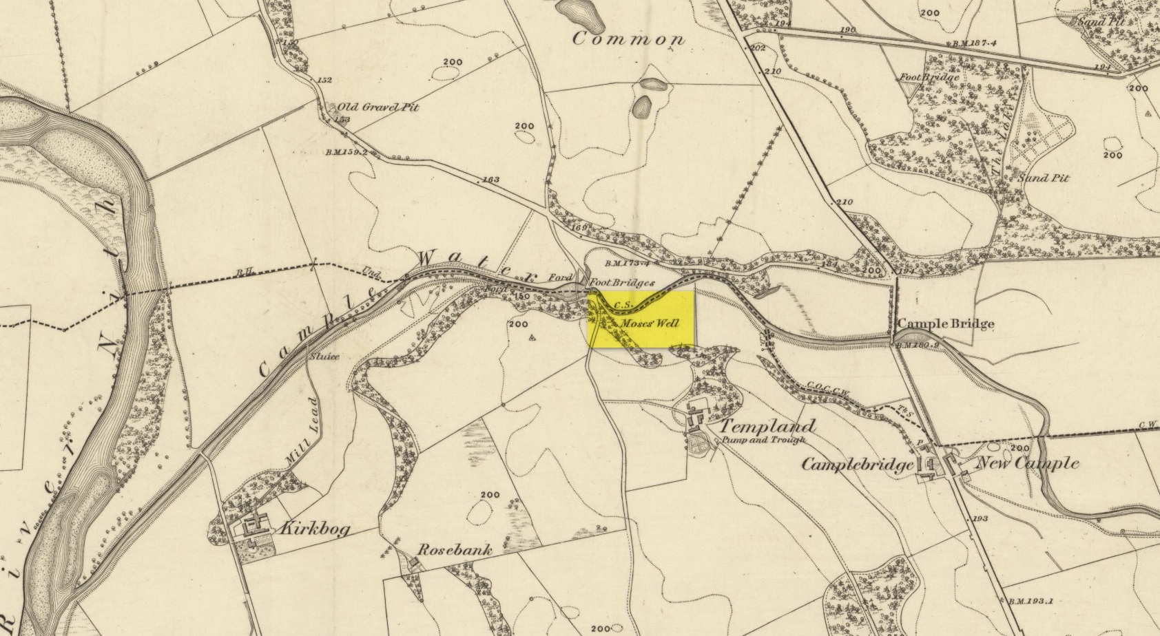
This little-known Biblical-sounding spring has apparently long since fallen back to Earth (perhaps there might be some local folk who could find out for certain). Shown on the 1861 Ordnance Survey map as being at the side of the wall in the small copse of trees—immediately east of kirk- place-names and a half-mile north of St Ninian’s Well—it was briefly described by T.C. Ramage (1876), who seemed to know nothing of its lore, merely telling us that,
“on Templand farm, close to the wooden bridge over the Cample, there is Moses’ Well, an unusual designation, but which some Knight Templar may have given in remembrance of his toils in Palestine.”
The Templar designation was deemed by Ramage to come from the name of the farm. However, a few years prior to this, the early Scottish place-name surveyors were traversing the area and found from local people how it derived “its name from a Tinker named Moses Marshall who with his family lived near it in a Camp during the time they had the small pox.” The Well was also included in the Morris survey (1982), but without comment. Another Moses Well can be found 44½ miles to the northeast, near Galashiels at NT 4046 4306.
There are two large boulders here, one of which was deemed the Ashlar many moons back. You can approach it from the lazy way: park y’ car at the top of the road by the Whetstone Gate TV masts and walk east right along the boundary path till you get here. The better way is from Twelve Apostles: from there walk a coupla hundred yards north to the Lanshaw Lad boundary stone, where a small path heads west. Along here for another coupla hundred yards, then hit the footpath south for the roughly the same distance again. You’ve arrived!
Archaeology & History
The Ashlar Chair is ascribed in folklore, said Harry Speight (1892), “to be a relic of druidism,” as one of its titles in ages past was the Druid’s Chair. In the nineteenth century it also became known as the Etching Stone, (Smith 1961-63) but it has retained its present title for more than two hundred years. Shaped more like a couch than a chair, its present title—the Ashlar—is important in ritual Freemasonry, which has two aspects to it: the ‘rough’ and the ‘perfect’. The first represents the neophyte; the latter, the illumined one. Oaths are sworn on the ashlar, and laws are spoken from it. In its higher aspect it is representative of the spiritual maturity of evolved man.
Ashlar Chair on 1851 map
Although there are no public records as to who gave the site its present name, the land which lays before it, The Square, is an even greater indicator that this rock was was considerably more than just a curious place-name, for the open moorland that is overseen from Ashlar Chair—The Square — is 396,000 square yards of flat open heathlands that have never been archaeologically explored. The Square is also one of the most important elements of Freemasonry: representing the manifest universe, its laws are spoken from the Ashlar. (Jones 1950)
Between the two of them, represented here in the landscape near the very tops of these moors, we have a form of late geomancy, although the names of our geomancers are nowhere to be found. It is obvious though, simply from the name of the land, that dramatic ritual of some form was enacted here. In recent times, ritual magickians from differing Orders have found the place most effective, as have wiccan folk and other pagans who have frequented it at the summer solstice. The possibility that some members of the Grand Lodge of ALL England (a legendary Masonic Order, said by the modern London masons not to have existed until the eighteenth century) gave this place its name is not unreasonable. Records show that in the fourteenth century at least one member of the Order, Sir Walter Hawksworth, frequented ritual circles on these moors; and another member of the same Lodge from the nearby Washburn valley was an ally to the Pendle and Washburn witches who, we know, met on these moors at Twelve Apostles stone circle and probably the Ashlar. But it proves nothing I suppose. (I tend to believe (not a necessarily healthy viewpoint) that the Grand Lodge did use the Ashlar as one of their moot points, along with the Pendle and Washburn witches.)
Its primary geomantic attribute is as an omphalos. Geographically the Ashlar Chair is the meeting-point of Bingley, Burley, Morton and Ilkley moors and, metaphorically speaking, when you stand here you are outside the confines of the four worlds yet still a purveyor of them.
Nature’s cups-and-grooves on the Ashlar
Upon the large rock itself it are carved the faint initials, “MM, BTP, ISP and IG, 1826.” Several early records described cup-and-ring designs on the Ashlar: firstly in Forrest & Grainge’s (1868) archaeological tour; then in Collyer & Turner’s Ilkley (1885); and lastly by the great Yorkshire historian and topographer Harry Speight (1892, 1900), who said “it bears numerous cups and channels.” Although we can see some of these on top of the Ashlar, they are mainly Nature’s handiwork. It is possible that some man-made cup-and-rings once existed on the rock, but if so they have eroded over time.
References:
Bennett, Paul, The Old Stones of Elmet, Capall Bann: Milverton 2001.
Collyer, Robert & Turner, J.H., Ilkley Ancient & Modern, William Walker: Leeds 1885.
Forrest, C. & Grainge, William, A Ramble on Rumbald’s Moor, among the Dwellings, Cairns and Circles of the Ancient Britons in the Summer of 1867 – Part 1, W.T. Lamb: Wakefield 1868.
Jones, Bernard E., Freemason’s Guide and Compendium, Harrap: London 1950.
Speight, Harry, Chronicles & Stories of Old Bingley and District, Elliott Stock: London 1892.
Speight, Harry, Upper Wharfedale, Elliott Stock: London 1900.
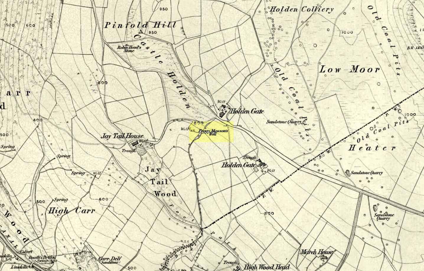
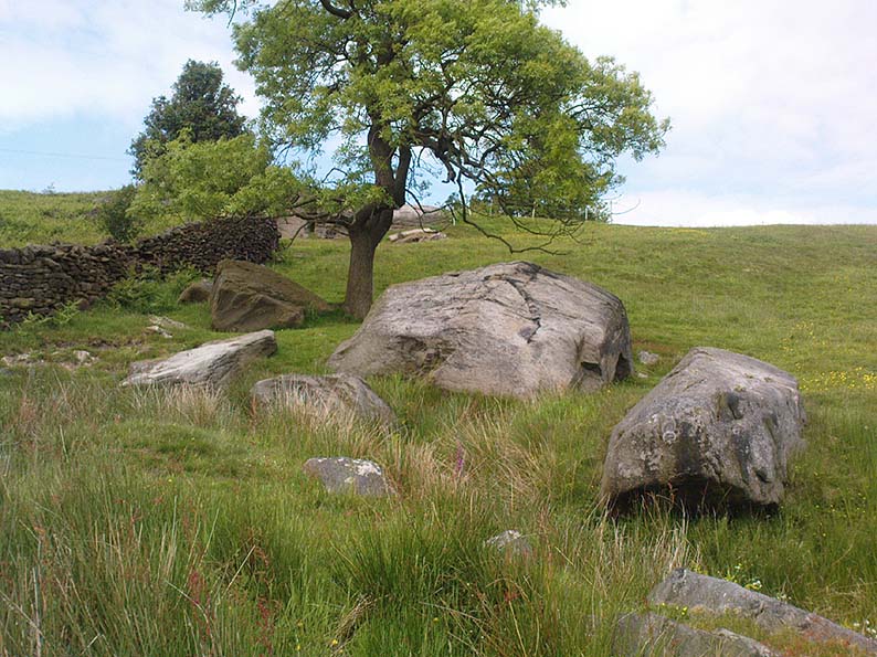
From Riddlesden, take the road up to the moorland and Rivock Edge. When you reach the top (Silsden Road), turn left. Go on for about 600 yards till you reach the lovely tree-hidden old cottages of Holden Gate, on your right. Stop — and walk down the footpath opposite from here. As the wall goes down, you’ll notice a stream in the next field to your left, emerging from a clump of large rocks. That’s it! (there’s a footpath in the next field from the roadside)
Archaeology & History
Shown on the first OS-map as ‘Peggy Mawson’s Well,’ little else seems to known of this place; though it obviously got its name after the local lady, Peggy Mawson. I can find no further information about this lady, nor why the site was named after her. Any help here would be hugely appreciated!
Peggy Mawson’s Well – now drained-off through pipes
Sadly the waters from beneath the rocks have been channeled into a couple of pipes and the well no longer runs. All that’s left is a small boggy region just in front of the boulders. You have to walk about 100 yards further down the field where the water emerges from a modern pipe. It doesn’t taste as nice as it originally did when coming straight from the ground, but it’s still quite drinkable (certainly beats any of the chlorinated stuff* that customers are forced to pay for, whether we want it or not – and most people don’t want it).
Folklore
This site has acquired modern folklore, but sadly no early traditions have been found. Whelan & Taylor (1989) thought that Peggy Well’s “dedication suggests a connection with St. Margaret,” which unfortunately isn’t the case. Several years later another writer, Val Shepherd (1994), spun the speculation even further, not checking the historical background to the site, and thought that “the well’s name may be derived from the water spirit, ‘Peg,’ who gave her name to other wells.” Sadly neither idea holds any sway.
References:
Shepherd, Val, Historic Wells in and Around Bradford, HOAP: Loughborough 1994.
Whelan, Edna & Taylor, Ian, Yorkshire Holy Wells and Sacred Springs, Northern Lights: Pocklington 1989.
* Anyone know about this: surely because the water companies chlorinate and add other undesirable toxins into our tap water, what we’re actually drinking is a very weak solution and not actually water. Isn’t that a trading standards violation?