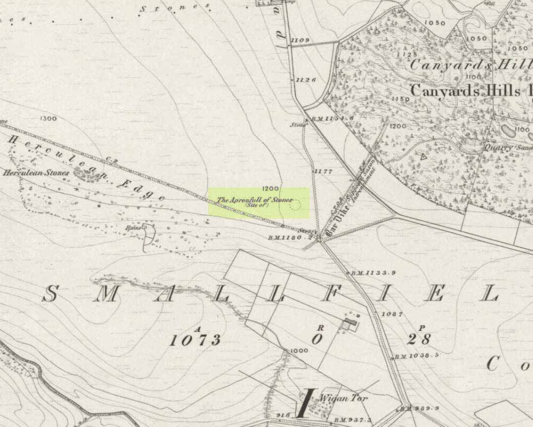
This was another example of the many giant cairns that scatter the upland moors on the Pennines, but much of it has been destroyed, with some halfwits in recent years cutting a track right through whatever remains there might have been! It was first described in John Watson’s (1776) essay on the local antiquities of Bradfield and district where, in relative conjunction with the curious Bar Dike, he told that “this is not the only curiosity on this common.” He continued: “there is on one part of it a large carnedde, called by the country people the Apron-full of Stones”, where he conjectured there laid a British tribal chief after he’d been slaughtered by the Romans. This might have been the folklore of the place, but we know such places were thousands of years earlier than the Romans.
It was later described in Joseph Hunter’s Hallamshire (1819) as a giant barrow, or ‘vast carnedde’, even then in the past tense; but some recent investigation here found “a few small stones and some lumpy turf which looked to be covering a few clumped stones.” The site requires further investigation by local people to assess the state of damage inflicted on this once great tomb.
Folklore
Said to have been the site of a local battle in ancient times; this is also another site which, as A.H. Smith (1961) tells, “is explained in folklore by tales of the devil undertaking some major building project and tripping up, only to deposit his apronful of stones” here. Does anyone out there have any more info on this place?
References:
Hunter, Joseph, Hallamshire: The History and Topography of the Parish of Sheffield in the County of York, Lackington: London 1819.
Smith, A.H., The Place-Names of the West Riding of Yorkshire, Cambridge University Press 1961-63.
Watson, John, “An Account of some Hitherto Undescribed Remains of Antiquity”, in Archaeologia, volume 5, 1776.
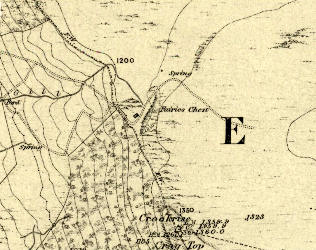
This is an awesome beast! You can either approach it from Nettlehole Ridge ‘stone circle’ as I did, or take the more sensible approach and begin from Embsay village, walking up the path towards Embsay reservoir and onto the moorland heights of Crookrise Crag, 1350 feet above sea level. Worra view! But keep walking a little more, downhill, and it’ll hit you right in the face!
Archaeology & History
Fairy’s Chest, Embsay Moor
Known as an abode of the little people in the 19th century and shown on the earliest Ordnance Survey map of the region, I know of no previous accounts of this giant elongated boulder, forty feet long and nearly the same size as our legendary Hitching Stone that’s nestled below the small cliffs. The boulder is surrounded by what seems like cairn-material on all sides (though it doesn’t look prehistoric). You’re looking straight west from here, right at the three small paps of Sharp Haw, Rough Haw and Flasby Fell. If you like huge rocky outcrops, this (and others nearby) will make your day!
Folklore
Said to have been the abode of the little people in ages gone by; though even an old chap we met on our wander here told us how the legends it once held “have died with the old folk it seems.”
It seems there’s not been a lot of archaeohistory written about this ruined site — nor its companion that was once visible 50 yards to the west. In Richard Feachem’s (1977) gazetteer he described it simply as:
“a turf-covered stony mound some 10ft in height, standing in the middle of an enclosure formed by a ditch with a wall on its inner lip, which is best preserved on the west.”
Folklore
A common aspect of faerie-lore are incidences of apparent time-lapses — beloved in modern times in certain UFO encounters (Vallee 1969; Keel 1970). Such was the case here, in the story described at this ruinous old site by George Sutherland (1937). He wrote:
“Two men carrying a small keg of whiskey for the New Year festivities were passing the church of Bruan. They heard stirring bagpipe music and a few hundred yards further on they came to the Bruan Broch and found it open, and saw a number of the little folk in green dancing merrily to the music. One of the men was eager to join them in the dance and went in. The other man was more cautious and remained outside, and waited patiently until his friend would have his dance. A long weary time passed and his friend was not appearing. He went to the open door of the broch and called to his friend to come out. His friend said, “I have not got a dance yet!” After another long wait he shouldered the keg of whiskey and set out for home, never doubting but that his friend would return home before morning. Next day he called at his friend’s house to see if he had come home, and to his consternation found that he had not. Then he went to the broch in the hope of finding him there, but the broch showed no trace of a door, and no trace or soil or stones having been disturbed since the days of King Brude MacBile, and there was no appearance of man or fairy. It was an old belief that in such a case the same scene would be enacted in the same place in a year after, and accordingly on the anniversary of that day he went to the Bruan Broch. It was open, the music and dancing were going on as before, and his friend was there. He put some iron article in the door to prevent the fairies from closing it… He went to the open door and said to his friend, “Are you not coming home now?” His friend replied, “I have not got a dance yet.” He told his friend that he had been a year in the broch, and that it was surely time for him to come home now, but his friend did not believe that he was more than an hour or so there. The man then made a rush at his friend, seized him, and dragged him out by sheer force, and they set out for home together. It was difficult for him to realise that his sojourn with the fairies was such a prolonged one, but the fact that his own child did not recognise him, together with other changes that had taken place, convinced him.”
References:
Feachem, Richard, Guide to Prehistoric Scotland, Batsford: London 1977.
Keel, John A., UFOs: Operation Trojan Horse, Souvenir Press: London 1970.
Sutherland, George, Folklore Gleanings and Character Sketches from the Far North, John-o-Groats Journal: Wick 1937.
Vallee, Jacques, Passport to Magonia: From Folklore to Flying Saucers, H.Regnery: Chicago 1969.
When Pete Glastonbury brought us here, we walked east out of the Avebury stone circle and up the Wessex Ridgeway track. When you hit the “crossroads” at the top of the rise a mile along, go across the stile into the grasslands for a few hundred yards till you hit the obviously-named “Gallops” racecourse-looking stretch. Walk down for a few hundred yards till you hit a footpath on your left that takes you across and down grasslands that takes you slowly into the valley bottom. You’re damn close!
Otherwise (and I aint done this route!), walk up the footpath straight north from Clatford village, up the small valley for about 1km. You’ll eventually see this great stone heap in the field on your left!
Archaeology & History
I was brought here one fine day last year in the company of PeteG (our guide for the day), Geoff, June and Mikki Potts. Twas a fine foray exploring the various prehistoric sites on the lands east of Avebury — but it was my very first venture to this site, the Devil’s Den — and a grand one it was indeed! Standing close to the small valley bottom a couple of miles east of the great stone circle, this megalithic monument is thought to be neolithic in origin.
When H.J. Massingham (1926) came here, the day and spirit of the place must have felt fine, as he described,
“its three uprights and capstone stand forlornly in the midst of an alien sea of ploughland swinging its umber ripples to the foot of a stone isle, drifted nearly four thousand years from the happy potencies of its past.”
And, on many good times here no doubt, for many people, such feelings still hold…
A.C. Smith’s Devil’s DenColt Hoare’s Devil’s Den
It was described by the President for the Council of British Archaeology, Paul Thomas (1976), “as a setting of four sarsen uprights with a capstone”, whereby four uprights have not been noticed here since very early times. Not sure how old he was though! Today the very large capstone weighing upwards of 20 tons rests gently upon just two very bulky upright monoliths. A third is laid amidst the great tomb , overgrown and sleepy, touching one of the two uprights….
The cromlech itself seems to have once been part of a lengthy mound that was covered in earth, “about 230ft long and 120ft broad, now virtually removed by ploughing.” On top of the great capstone are at least two cup-markings: one of them with a possible oval-shaped line carved out onto the edge of the rock (similar to the C-shaped carving on the nearby Fyfield Down cup-marked stone), but this needs looking at in various lights so we can ascertain whether it has a geological or artificial origin.
Stukeley’s Devil’s Den
Suggested by Edwin Kempson (1953) and also by Aubrey Burl (2002) and other dialect and place-name students to have originally been called Dillion Dene — “the boundary marker in the valley” — this collapsed chambered tomb has had many literary visitors, from William Stukeley onwards. When the reverend Smith wrote his great tome in 1885, he gave an assessment of those who came before him, saying:
“This is a noble specimen of the Kistvaen: it stands erect in its original position, only denuded of the mound of earth which, I venture to say (on the authority of the Rev. W.C. Lukis and others best acquainted with these remains) at one time invariably covered them: and this massive erection of ponderous stones is known as the ‘Devil’s Den’, and offers an exceedingly fine specimen of the kistvaen to those who have not made the acquaintance of these ancient sepulchres in other counties. It is not only perfect in condition, but of very grand dimensions; moreover, it is well known to everybody who takes the slightest interest in Wiltshire antiquities… Stukeley says very little of this kistvaen, though he gives several plates of it (in Abury Described), his only remark being: “An eminent work of this sort in Clatford Bottom, between Abury and Marlborough.” Sir R. Hoare (in Ancient Wiltshire, North) is more enthusiastic, he says: “From Marlborough I proceed along the turnpike road as far as the Swan public house in the parish of Clatford, and then diverge into the fields on the right, where, in a retired valley amongst the hills, is a most beautiful and well-preserved kistvaen, vulgarly call’d the ‘Devil’s Den.’ It has been erroneously described as a cromlech. From the elevated ground on which this stone monument is placed, it is evident that it was intended as a aprt annexed to the sepulchral mound, and erected probably at the east end of it, according to the usual custom of primitive times.””
In more recent years, Terence Meaden (1999) has suggested that the Devil’s Den may actually have been a simple cromlech and never had any covering mound of earth. In his Secrets of the Avebury Stones he described how,
“The vertical megaliths must have been set up firmly first and then, quite possibly, a mound was raised outside and between them. A very long ramp could have been built next, along which the capstone was dragged until it lay on top of the vertical monoliths, after which both mound and ramp would be removed as far as possible. Such an operation, if correct, would explain why the stones of Devil’s Den now stand on an obviously artificial eminence; and why the much-spread remains of a long mound oriented NW-SE, about 70 metres (230 feet) long and 40 metres (130 feet) broad, were seen and described by Passmore in 1922. One should not necessarily assume that the stones are the remains of a chambered long barrow, although they might be.”
And you’ve gotta say that unless we have hardcore evidence to the contrary, his summary is quite possible. However, it seems here that Meaden has simply utilised this logic to enable him to posit another reason — a “good one” he calls it — for this suggestion, i.e.,
“its capstone seems to have profiles of heads carved upon two, perhaps three of its sides; suggesting that, if the art was meant to be seen, the capstone was never covered with earth.”
Devils Den on 1889 map
Unfortunately however, these possible “carved heads” on the sides of the capstone more typify Rorscharch responses to natural geological shapes scattering rocks all over the planet. Up North, if we were to attempt this sorta suggestion, we’d have millions of such carved heads popping up all over the place. It’s a nice idea, but somewhat unlikely.
Folklore
The old dowser Guy Underwood (1977) was renowned for locating water lines* in and around many of England’s prehistoric sites, and the same pattern was recorded here. He told that the Devil’s Den marked the site of a blind spring “of exceptional importance.” He continued:
“The Devil’s Den dolmen marks the source of a multiple water line which forms a maze, marked by stones, about 200 yards to the northwest. It terminates at a well, where two tracks cross about a mile further west. This site is likely to have had special sanctity and would be interesting to excavate.”
Whilst the importance of water was understandable in ancient days, some other folklore attributes derive from quite different ingredients. The common theme of “immovability” is found here, as described by reverend Smith (1885) again who, amidst other peculiarities, told the following:
“There are various traditions connected with it. I was told some years since, by an old man hoeing turnips near, that if anybody mounted to the top of it, he might shake it in one particular part. I do not know whether this is the case or not, though it is not unusual where the capstone is upheld by only three supporters. But another labourer whom I once interrogated informed me that nobody could ever pull off the capstone; that many had tried to do so without success; and that on one occasion twelve white oxen were provided with new harness, and set to pull it off, but the harness all fell to pieces immediately! As my informant evidently thought very seriously of this, and considered it the work of enchantment, I found it was not a matter for trifling to his honest but superstitious mind; and he remained perfectly unconvinced by all the arguments with which I tried to shake his credulity.”
References:
Burl, Aubrey, Prehistoric Avebury, Yale University Press 2002.
Goddard, E., “The Devil’s Den, Manton, Wiltshire,” in The Antiquaries Journal, volume 2, no.1, January 1922.
Gomme, Alice B., ‘Folklore Scraps from Several Localities’, in Folklore, 20:1, 1909.
Grinsell, Leslie V., Folklore of Prehistoric Sites in Britain, David & Charles: London 1976.
Kempson, E.G.H., “The Devil’s Den,” in Wiltshire Archaeology & Natural History Magazine, 55, 1953.
Massingham, H.J., Downland Man, Jonathan Cape: London 1926.
Meaden, Terence, The Secrets of the Avebury Stones, Souvenir Press: London 1999.
Smith, A.C., A Guide to the British and Roman Antiquities of the North Wiltshire Downs, Wiltshire Archaeological & Natural History Society 1885.
Thomas, Nicholas, Guide to Prehistoric England, Batsford: London 1976.
Underwood, Guy, The Pattern of the Past, Abacus: London 1977.
Wright, Joseph, English Dialect Dictionary – volume 2, Henry Frowde: London 1898.
* Those people who allege they can dowse will always find water in their first few months, if not years, of sensitivity. There is a pattern nowadays of people using dowsing tools and, when the rods cross (or whichever accessory they get their reactions from), they allege they are connecting with unknown energies, ley lines and other such items; but this is simply incorrect. The primary dowsing response is water (life-blood) and it takes much practice over long periods of time to even begin isolating leys or other occult phenomena.
Crowned by a clump of trees (planted in 1740), this hilltop site is one of the more impressive of a number of tombs hereby, with its nearest other neighbour being 70 yards southeast of here. One of Dorset’s early tribal meeting places (Anderson 1934), the tomb was illustrated on Isaac Taylor’s 1765 map of the region and was dug into in 1858 “on the orders of a local magnate” (Marsden 1999), damaging some substantial portion of the tomb. Of this, craniologist and antiquarian John Thurnam was most displeased; for in his description of the opening of Culliford Tree he wrote:
“A wide trench had been dug through it one side, from the summit and the rubble which had been thrown out had not been replaced… Another subject of regret was the fact that though, as we were told by the neighbouring rustics, human remains, with pottery and certain other relics, were found in the barrow, no authentic account of the exploration had, so far as we could learn, been put to print.”
Leslie Grinsell (1959) found the same trouble in his assessment of this site; and the Royal Commission (1970) lads could only describe the site thus:
“Large trench on south and top almost certainly dug in 1858 when four secondary extended inhumations, one with necklace of amber and two gold-plated beads, and cremation with incense cup in collared urn, were found.”
However, it seems that the necklace and gold-plated beads have been “lost” — i.e., someone has them in their own private collection somewhere!
Folklore
This is one of very few tombs in this part of the country where we find the tradition of fairy music. Grinsell (1959) told that:
“The Culliford Tree barrow, formerly the meeting place of the Hundred of Culllingford Tree, is also known as the Music Barrow from the belief that music could be heard beneath the mound by those who listened at the apex at midday.”
References:
Anderson, O.S., The English Hundred-Names, Lunds Universitets Arsskrift 1934.
Marsden, Barry M., The Early Barrow Diggers, Tempus: Stroud 1999.
Royal Commission on Historical Monuments, An Inventory of Historical Monuments in the County of Dorset – Volume 2: South-East, Part 3, HMSO: London 1970.
Warne, Charles, Celtic Tumuli of Dorset: An Account of Personal and other Researches in the Sepulchral Mounds of the Durotriges, Smith: London 1866.
The ancient and once sacred water source was described in local place-names such as Holywell strete and Holywellbrugge from the 13th Century onwards; yet despite it being at the heart of one of the cradles of the English church, there are only scant accounts of the legendary well down the centuries. The most detailed essay on this site was written by Tony Haynes (1986) in the specialist holy well journal, Source, more than 20 years ago. Haynes tells as much as it known of the site, saying:
“Late in the seventeenth century, when John Churchill, future Duke of Marlborough, pulled down his wife’s house and built a new mansion in the middle of Holywell Hill, thus creating a major diversion, the Holy Well was a feature of his terraced gardens. Maps of the period show the site of the well to be a focal point of his lawns.
“In 1815, Shaw’s guide to the town states, ‘The holy-well is still held in some esteem for its purity and salubrious qualities’. The Duke’s residence later became the property of the Earl Spencers. It eventually fell into ruin and was demolished in 1837, and the original route of Holywell Hill was restored, no doubt much to the relief of contemporary coach and wagon drivers. After this time, the grounds were left to decay. Ten years later little remained of the gardens but a fishpond and the Duke’s ‘canal’ marking the original course of the River Ver.
“Of the Holy Well, in his History of St Albans published in 1893, Charles Ashdowne laments that: “It is now remembered only as a muddy depression, sheltered by the remains of a dilapidated wall and a mournful specimen of blackthorn.” Eventually the land was acquired by the St Albans School for Boys as a playing field. “The exigencies of athleticism necessitated the ground being levelled and turfed over,” Ashdown continues, “and it is much regretted that there is nothing to mark the site of what was essentially one of the most ancient of English Holy Wells.”
“This is confirmed by a Miss Lightfoot of Holywell Hill. In 1960, when she was 85, she wrote in a letter to Hertfordshire Countryside magazine: ‘I remember the well quite well, for as a child I often went round it. It was surrounded by a fence, inside was a tree, water and weeds – not very inviting.’
“The ‘Old boys’ of St Albans School recall, about fifty years ago, there being a concrete slab at one end of their football pitch which they knew as the site of the well. Their playing field fell into disuse in the 1960’s, but the exact site of the well was lost long before this.”
Naff all is visible here nowadays, apart from some concrete square bitta brickwork that betrays any sense whatsoever of a once sacred site. Very disappointing indeed…..
Folklore
As with a great many British holy wells, this all-but-forgotten site was named after one of the early christian martyrs — in this case from as early as the late 3rd century AD. A number of early folklore texts describe St. Albans story, with Vernon Brelsford (1958) telling:
“Tradition states that on his way to execution he walked up a neighbouring hill where he prayed for water to quench his thirst, whereupon a fountain of water sprang up under his feet. Here he was beheaded on June 23, AD 303.”
This date indicates the site probably replaced an earlier, heathen midsummer solstice custom at, or near this spot. Another tale tells that when St. Alban had been executed, the saint’s head rolled down the hill and into the waters of the well below. Mr Haynes (1986) described other early folklore which seems to relate to St. Alban’s Well, telling:
“An early reference to the well can be found in the writings of Brompton who lived in the time of Richard II. He recorded that the father of King Arthur, a British Prince, was severely wounded in the battles with the Saxons:
‘A long time he lay confined to his bed until at length he was cured by resorting to a well or spring not far distant from the city. at that time reputed to be salubrious; and for that reason, and for the cures thereby performed, esteemed holy; and blessed in a peculiar manner with the flavour of Heaven.’
“Two devout sisters built a shelter near the well. They served the weary pilgrims who trudged up the steep hill towards Alban’s shrine in the abbey, by dipping, or ‘sopping’ their bread in the holy water and offering it to the thirsty travellers. Hence was founded Sopwell Priory, nearby.”
References:
Brelsford, Vernon, Superstitious Survivals, Centaur Press: London 1958.
Gover, J.E.B., et al, The Place-Names of Hertfordshire, Cambridge University Press 1938.
This is an outstanding site visible for miles around in just about every direction – so getting here is easy! If you’re coming from Harrogate, south down the A658, turn right and go thru North Rigton. Ask a local. If you’re coming north up the A658 from the Leeds or Bradford area, do exactly the same! (either way, you’ll see the crags rising up from some distance away)
Archaeology & History
Almscliffe Crags – looking east
This giant outcrop of rock rises out from the meadowlands here like a miniature volcano, visible for many miles all round. The history and legends surrounding the aged edifice are prodigious and the view from its tops on a fine day is one to be remembered. It is likely, although there is little corroborative historical evidence, that is was an “omphalos”, or navel centre of the universe for the local people many centuries ago. A great cutting runs through its centre and “runs from nearly north to south, and forms the boundary between the townships of Rigton and Stainburn, so that a portion of the rock is in each township.” On the respective sides of this division are carved the letters “T.F.” and “E.L.”, being the initials of the families who owned the land here in olden days, Thomas Fawkes [of the legendary Guy Fawkes’ family] and Edwin Lascelles, of the ancient Harewood family.
Although Almscliffe Crags have been described in a great many local history books, it almost beggars belief to find it omitted from all the ancient mystery or “sacred sites” books ever written. Curious… Such lesser sites as Alderley Edge, the Cow and Calf rocks, Kilburn’s White Horse, Twelve Apostles stone circle, and many more, whilst having their respective virtues, don’t touch this place for ritual or sacred intent.
First described in the early 13th century records of Fountains Abbey, A.H. Smith (1961) thought the name of Almscliffe itself originally came from a hypothetical lady’s name, which seems an all-too-easy proclamation to make, instead of the humble option of “I don’t know”! But Smith wasn’t the only one to throw some curious ideas up about the etymology of Almscliffe. Said by some local etymologists to derive from the Celtic Al-, a rock or cliff, and mias, an altar, there are other attempts to bring its rocky form into a consensus meaning. The anglo-saxon Ael or El, being fire, and messe, or mass; and the Scandinavian Ormcliff, being the “cliff of the serpent”. In Jones’ History of Harewood (1859), he tells
“it to have derived its name from the distribution of almes, at certain times, agreeably to the tenor of legacies left to the chapel which stood there in the sixteenth century, and was at that time dedicated to the Virgin Mary.”
It’s difficult to say which one tells its true title. Many a druidic tale has also been carved into its form. Such is the nature of this site that Grainge (1871) wrote how,
“it would not be difficult to show, with the exception of the artificial temple or circle of stones, this place possesses all the accessories of that ancient worship as…typical of the worship of the sun.”
Simpson’s 1879 drawing of the Almscliffe ‘cromlech’
A remark that was even echoed by one of Yorkshire’s finest and most sober historians, Harry Speight. (1903) Grainge also pointed out that in his day there were three standing stones by the great Crags, one fallen, but “two of these rocks yet stand upright.” A few years later we find that the ranting christian writer, Henry T. Simpson (1879), described similar megalithic remains here, though his description was of a “cromlech.” (illustrated here) I can find no trace, nor further references to these relics; but think it reasonable to suggest that, perhaps, Simpson’s cromlech and Grainge’s standing stones may have been one and the same monument.
In the field 100 yards immediately north of the Crags (the one with the two rocks in it) there used to be seen the remains of some primitive early walling, suggestive of a small, early settlement site. Very little can be seen of these remains today and, as far as I’m aware, no archaeological survey was ever done of them. In all honesty, it’s highly probable that a number of other important prehistoric sites were once in evidence at varying distances around Almscliffe Crags…
Folklore
The creation myth of Almscliffe tells that, long long ago, the great giant Rombald — whose main place of residence tended to be Ilkley Moor — was having a fight with the devil upon his homeland heath. As is common in the myths of giants, the ‘devil’ picked up a great boulder and threw it at Rombald, but it missed and fell just short of the village of North Rigton, creating Almscliffe Crags. A variation of this tale tells that it was Rombald and his wife having the argument and she threw the stones to create the place. Several sites have been named as the place where the mythological argument occurred: the Cow and Calf rocks, the Great Skirtful and Little Skirtful of Stones all cited in the folktales of our Yorkshire peasants. Another variation of the tale tells that the devil was simply carrying some stones (as devils and giants are renowned to do in the folk-tales of the world) and he accidentally dropped them where the Crags now stand. Such rock-throwing tales are, once more, symptomatic of cailleach tales more commonly found in Ireland and Scotland.
There are a great many cup-markings on the top surface of these Crags, most of which seem natural, but it is not unreasonable to think that, perhaps, some may have been carved by human hands? (not sure misself) Eric Cowling (1946) sincerely believed the antiquity of some carvings here. One of them particularly, three feet across and eighteen inches deep, though seemingly natural, has for several centuries been known as the “Wart Well.” Its name is attributed to folklore that is more commonly found in Ireland and the Scottish highlands; that is, should you have a wart, prick it with a pin until a drop or two of blood drips into the water that gathers in the stone bowl, then dip your hand in afterwards. The wart is sure to vanish. Another method to achieve the same end is to merely wash the skin affliction in the water, and it will soon fade. (Interestingly, an old psychotherapist friend, afflicted with the damned things, did just this and they promptly vanished.)
A more minor creation myth tells that the stone bowls we see on top of the Crags here – including the Wart Well – was actually made when the giant Rombald stepped from his home onto the Crags and left his footprint embedded in the rock face. He was said to have made it in just one step, from the Giant Skirtful of Stones prehistoric cairn [where one legend reputes him buried].
Faerie folk were also long held to live here. On the northwest side of the Crags is the entrance to a small cave that was always known as the Faerie’s Parlour, as it was said to be an entrance to their supernatural world. In times past, many people have scrambled down into the cave, but never reached their Otherworldly paradise. William Grainge (1871) wrote how the little people “were all powerful on this hill and exchanged their imps for children of the farmers round about.” This is typical of old changeling lore! In outlying villages surrounding the Crags there is a particular excess of faerie and old heathen lore.
One very curious-sounding tale tells how a goose was sent down the hole and, after some considerable time, re-emerged 3½ miles away out from a well near Harewood Bridge. The goose is one of the many symbols of the sun and one of its primary symbolic attributes is that of winter. Interestingly perhaps, as the rock art writer Graeme Chappell has pointed out, the underground journey of the goose from Almscliffe to Harewood Bridge coincides closely with the rising of sun on morning of the winter solstice. This tale may simply be a folk remnant — and an archaic one at that — of just that event: ritualising winter solstice from these Crags. In Norse lore, shamans tell of geese carrying the great god Wotan across the skies at the coming of the Yule period.
Another ritual date that was celebrated here was Beltane, or May 1. Not only do we find many of the outlying villages possessed their own maypoles, but in 1879 Mr Simpson of Adel reported seeing Beltane fires atop of these rocks. Other meetings were made here as the Crags are spliced in half by the local boundary line, and perambulation records show that people came here during the ‘beating of the bounds’, as they used to be called. This boundary perambulation moot ingredient is what strongly implies the site to have had ritual importance. And the fact that a mass of folktales emerge from here adds to this. Then of course we have the physical situation of the Crags at the heart of the mid-Wharfedale landscape. All these ingredients combined, strongly suggest the site would have been, not just the ritual meeting place of tribal elders in pre-christian times, but an omphalos: it rises majestically from the land and all monuments gaze towards its giant form. Important giant prehistoric monuments from the hills miles away tell of myths that come and go from this proud mass of stone. Although we have other omphali just over the extended horizons from Almscliffe, this is where the World began in the creation myths of ancient times in mid-Wharfedale, at the heart of the ancient kingdom of Elmet.
But there is still more lore to be told of these rocks…
The centre piece of the Crags is known as the Altar Rocks. Upon its western side is carved the “figure of a large tree, which we take to be the monogram of the Celtic Jupiter,” says Grainge. This assumption is derived from an eighteenth century writer who, said Speight (1903), told that “Almnus and Alumnus are titles of Jupiter, to whom this high altar was dedicated.”
The highest part of the Crags, to the west, is known as Lover’s Leap where, in 1766, a daughter of a respectable Rigton farmer of the name Royston, having been disappointed in love, decided to kill herself. She jumped, so legend reputes, from a point some sixty feet above ground, but a strong wind blowing at the time caught hold of her dress and carried her through the air until she landed safely in an adjoining field with naught but a sprained thumb! The said lady realised the stupidity of her ways and was said to have lived out a long and fine life.
In recent years earthlights (UFOs) have been seen floating above and around the great outcrop. It is likely that these were the same things which, in days of olde, the people would call the faerie. I highly recommend visiting the place!
References:
Bennett, Paul, The Old Stones of Elmet, Capall Bann: Milverton 2001.
Bogg, Edmund, From Eden Vale to the Plains of York, James Miles: Leeds 1895.
Bogg, Edmund, Higher Wharfeland, James Miles: Leeds 1904
Cowling, E.T., Rombald’s Way, William Walker: Otley 1946.
Eliade, Mircea, Patterns in Comparative Religion, Sheed & Ward: London 1958.
Grainge, William, History & Topography of Harrogate and the Forest of Knaresborough, J.R. Smith: London 1871.
Jones, John, The History and Antiquities of Harewood, Simpkin Marshall: London 1859.
Simpson, William, Archaeologia Adelensis, W.H. Allen: London 1879.
Smith, A.H., The Place-Names of the West Riding of Yorkshire – volume 5, Cambridge University Press 1961.
Speight, Harry, Kirkby Overblow and District, Elliott Stock: London 1904.
Plenty of ways of approaching this huge fella! Personally, I’d take it from the steep valley immediately east and north where the ramparts drop you down the hill, if only to get a decent idea of the scale of the thing! But those of you into taking it easy can do no better than take the country road south out of Poynings village (towards Brighton), down Saddlescombe Road, for just under a mile, where you should take a right-hand turn along the Summer Down lane for a mile. You’ll then hit the Devil’s Dyke Road. Turn right here and go to the end. You’re right in the middle of it!
Archaeology & History
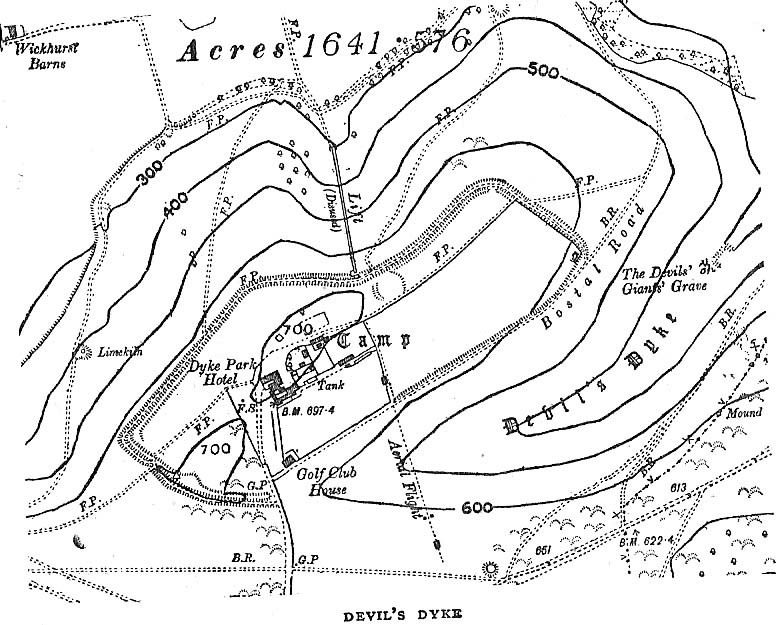
Early plan of Devil’s Dyke ‘camp’
Although most of this huge monument hasn’t been given the investigation it deserves — hence making knowledge of its origins more speculative than factual — as Jacquetta Hawkes (1973) wrote, seemingly all those years ago now, “it is known that a village lying half in and round them was occupied in the Belgic period at the end of the Iron Age.” And it’s certainly big enough! The encircling circuit of dykes themselves stretch all the way round a distance of more than 2150 yards long (that’s 1.22 miles, or 1.97km!), with the longest east-west axis being more than half-a-mile across.
Nowadays it seems, the Devil’s Dyke is the name given to the steep valley below the encampment, but a hundred years back it was the camp itself that was known by this name. Described by the wandering antiquarian R. Hippisley Cox (1927) as “a camp containing forty acres (with) very steep and difficult approaches,” another early account in The Antiquaries Journal — commenting on a ground-plan of the site from the Brighton and Hove Herald of 1925 — told:
“The heavy encircling lines represent ramparts, and the thin line marks the outer margin of the accompanying ditch. A spur renders the earthwork weakest on the south-west, and the rampart is therefore highest between the points 1 and 3, rising 21ft vertically above the ditch, which is nearly filled up at the present time. On the north-west there is steep slope outside the camp, and the ramparts are considerably lower, the iner ditch being nearly obliterated. The outer rampart is now wanting betwen 7 and 8, but this inner one becomes stronger as the outer slope of the ground decreases, only to die away again on the south-east where the camp overlooks the steep Dyke Valley. A double-bank and inner ditch can still be traced from the north-east angle to a point near the old golf-club house.”
I first came here as a young lad and the site was lost on me (in them days, if monuments weren’t stiff and upright, I really didn’t see the point!). These days however, the size of it alone blows you away somewhat.
Folklore
As you’d expect the creation myths of this site and its edges relate to our old heathen friend, the devil! The landscape itself was, in old lore, the work of the devil (though prior to this, the devil was known in peasant-lore to be a legendary giant, though I am unaware of the name/s of the giant in question); and the great valley below the Devil’s Dyke encampment was actually dug out by Old Nick in the old tales. That old folklorist Jacqueline Simpson (1973) takes up the story:
“The Devil…had been infuriated by the conversion of Sussex, one of the last strongholds of paganism in England, and more particularly by the way the men of the Weald were building churches in all their villages. So he swore that he would dig right through the Downs in a single night, to let in the sea and drown them all. He started just near Poynings and dug and dug most furiously, sending great clods of earth flying left and right — one became Chanctonbury, another Cissbury, another Rackham Hill, and yet another Mount Caburn. Towards midnight, the noise he was making disturbed an old woman, who looked out to see what was going on. As soon as she understood what he was up to, she lit a candle and set it on her window-sill, holding up a sieve in front of it to make a dimly glowing globe. The Devil looked round, and thought this was the rising sun. At first he could hardly believe his eyes, but then he heard a cock crowing — for the old woman, just to make quite sure, had knocked her cockerel off his perch. So Satan flew away, leaving his work half done. Some say that as he went out over the Channel, a great dollop of earth fell from his cloven hoof, and that’s how the Isle of Wight was made; others, that he bounded straight over into Surry, where the impact of his landing formed the hollow known as his Punch Bowl.”
That’s the story anyway — take it or leave it! Of importance in this fable is the figure of the “old woman”: a much watered-down version of the cailleach figure of more ancient northern and Irish climes, where tales of her doings are still very much alive. And many are the tales of her battles with other giant figures, just as we evidently once had here.
Ghosts have been reported by local people upon this hill-top site; and there are a number of other folktales to be found here…which I’ll unfold over time as the months pass by…
References:
Anon., “Notes: The Brighton Dyke,” in The Antiquaries Journal, 5:4, October 1925.
Clinch, G., “Ancient Earthworks,” in Victoria County History of Sussex – volume 2 (edited by W. Page), St. Catherine’s Press: London 1905.
Cox, R. Hippisley, The Green Roads of England, Methuen: London 1927.
Hawkes, Jacquetta, A Guide to the Prehistoric and Roman Monuments in England and Wales, Chatto & Windus: London 1973.
Hogg, A.H.A., “Some Aspects of Surface Fieldwork,” in The Iron Age and its Hillforts (edited by M. Jesson & David Hill), Southampton University Archaeology Society 1971.
Simpson, Jacqueline, The Folklore of Sussex, Batsford: London 1973.
Simpson, Jacqueline, “Sussex Local Legends,” in Folklore Journal, volume 84, 1973.
A sacred water source that is thought to have taken its name from the adjacent church of St. Margaret (makes sense!). The site was described at some length in the fine work of Robert Charles Hope (1893), where he quoted extensively from earlier works:
“At the west end of this chappel, about three yards distant, is the well or spring, antiently and to this day called St. Margaret’s Well, being the very same that she by her prayers at the building of the chapple opened. Of which heare a certaine old English poet, who in the life of St. Frideswyde in the legend of English saints, speaking of her various fortunes and of her passage from Bampton to this place, saith thus:
Ther fer with her [fellows.] she be laft ther
And to serve Jhesu Christ . a chapel leet [raise.]
Ther as is yit a fayr cort . and a cherche fayr and swete
Arerid in the honour . of her and Seynte Margrete
As this mayde [lived.] ther . in holy lyf and clene
The maydenes that were with her . gone hem ofte be [bemoan.]
That water was sum del to fer . hem ofte for smale dede
And cride on Seynt Friswid . that she schold hem therof [rid]
This mayde Seynt Friswid . bad our lordis sonde
That he water thorw his gras . hem sente ner honde
So sprong ther up a welle . cler [enough] and clene
That fond hem water inowf . tho dorst hem nought be mene
That beside the cherche is [it] . in the west syde
That mony a mon hath bote do . and that men seggeth wide.
Over St. Margaret’s Well was a covering of stone, and thereon on the front the picture of St. Margaret (or perhaps St. Frideswyde), pulled down by Alderman Sayre, of Oxon, a little before the late war, 1639.
To this well also and her image and certaine reliques in the chapple did the people come on pilgrimage with as great devotion to ease their burdened soules and obtaine resolutions of their doubts, as they would to an oracle.
And here, also, when those maimed and unsound folke had bin cured either by bathing in, or drinking of; this water, hang up their crutches as a speciall memorandum of their cured griefs. For which end and purpose there were severall preists that inhabited here appointed by the Prior of St. Frideswide’s purposely to confess and absolve those pilgrims.
Near to this place it was that the Lady Edyne, of Wynton, the widdow of Sir William Lancelot, knight, had a vision. (See Twyne, xxi., 199.)
The well wee find almost to the last frequented by superstitious people, and especially about a hundred years before the dissolution. Soe much, that they were forced to enclose it–as in old time before, they had defended it–with a little house of stone over it with a lock and a dore to it. But all decaying and going much to ruine, at the suppression of St. Frideswyde’s Priory, was at last –I meane the little house–about twenty-five years agoe, pulled downe and quite taken away. Soe that now being overgrowne with nettles and other weeds, and harbouring frogs, snails, and vermin, scarce owneth the name of a well; noe more than the old and small building joyning to the north side of the chapple doth–as formally it did–a court.
The well is now in better condition. When I visited it on 25th October, 1887, the churchyard was tidily fenced and very neatly kept. At the well a descent of some five steps brought one to an arched vault, beneath which, in the centre of the flooring, was a round basin containing the water of the well, the surface of the water being about six feet below the level of the ground. On the wall above the arch was this inscription:
“S. MARGARET’S WELL.
S. Margaretae fontem, precibus S. Frideswidæ (ut fertur) concessum, nquinatum diu obrutumque in usum revocavit T. J. Prout, Aed. Xti alumnus, Vicarius, A. S. MDCCCLXXIV.
At the time of the restoration of this well, an Oxford wit, having regard to its proximity to the church, suggested for an inscription:
Ariston men hydor
When you open your pew-door,
This may comfort supply
Should the sermon be dry.
(Ibid., pp. 323-328, et seq.)
Denham Tracts, p. 151: The well of St. Margaret or St. Frideswide, in Binsey churchyard, scarce two miles from Oxford, is supposed to have sprung from the prayers of St. Frideswide, and many in olden times consulted it as an oracle on the state of their burdened souls; maimed and sick persons drank and bathed in the waters, and were cured by them. The stone edifice was in the last century destroyed, but has been restored.“
References:
Hope, R.C., The Legendary Lore of the Holy Wells of England, Elliot Stock: London 1893.
This large cup-marked stone was known by local people as the Clach na Sithean, or the stone of the fairies. Its smooth surface and well-cut grooves was said to be due to the fairies sharpening their knives upon it, and the straight cuts or grooves were tests of the keenness of their blades.
In addition to the fairies having hold over this stone, a brownie creature also roamed between here and the burn of Allt Mor. Although a dutiful creature, he commonly used to scare the women when they returned from the ceilidhs by chasing them and screaming a curious noise at them. But as well as this, he would also enter the local houses and farms after nightfall and, when the local folk were asleep, would clean the supper dishes and put them in their rightful places. But if there was no work to be done once he had entered their homes, he would take the dishes out and place them on the floors where they would be found in the morning by perplexed householders. Then they’d know that the brownie had visited. Sometimes he was a great help to the housewives, other times a nuisance. He became known to local people as Puddlefoot, or Cas an Lubain, but so offended was he by the name when he heard it, that he let out an almighty scream and vanished, never to be seen again.
References:
Kennedy, James, Folklore and Reminiscences of Strathtay and Grandtully, Munro Press: Perth 1927.


")
")

")
")
")
