Holy Well (destroyed): OS Grid Reference – SP 9848 0822
Also Known as:
-
St. James’ Well
Archaeology & History
Shown on the early Ordnance Survey maps of the town, Berkhamsted’s holy well was a place of some renown in bygone centuries. Today it is barely remembered. It was initially dedicated to St. James, as it was associated with a chapel dedicated to that saint close by, but it had a change of name when the legendary Brotherhood of St. John the Baptist became the new caretakers, so to speak. As a result of this, its history can be a little confusing to some folk!
In the late 12th century, pagan worship at this site came to the attention of Hugh of Grenoble, the Bishop of Lincoln, who visited the place to stop local folk performing their animistic practices (although the exact nature of such rites were not described, sadly). It didn’t work, obviously; as once the bonkers bishop had gone, local folk would have continued in their old ways, no doubt wondering who the hell the odd incomer had been who was telling them to stop doing what they had always done here at the cost of no one. And so the waters continued to be used under the mythic cover of old St James—for the time being at least.
 The well later became a centre of pilgrimage and and a hospital was been built close by dedicated to St James, where leprosy was treated and the curative waters from this well were used. St James’ Day was July 25 and an annual fair was held in Berkhamsted thanks to a Royal Charter of James I in 1619. Hertfordshire traditions relating to St James Day are described in Miss Jones-Baker’s (1974) fine survey on the customs of the county. But change was a-coming when a local monk had a dream that the waters of this “pagan spring” needed to be blessed and dedicated to the virtues of St. John the Evangelist and a shrine built where pilgrims could worship and be healed. And as Jones-Baker (1977) told us,
“The water of St John’s Well were thought to cure a variety of diseases; among these leprosy and scrofula (the King’s Evil) as well as sore eyes. There was also a persistent belief that clothing washed in its waters would impart good health to the wearers.”
In the period when the Protestant Reformation occurred, the well and its immediate surrounds apparently became derelict and overgrown. The Old Ways returned and local folk began to visit the waters again at night and the animistic rituals that would have been taken to other secret places returned to St. John’s Well. In this period a local physician, a Dr. Woodhouse, used the sacred waters as part of magickal rites to exorcise evil spirits!
In spite of the local authorities declaring in 1865 that the water was “unfit for drinking”, local folk later told otherwise. Its waters were still being used in the 20th century and its traditions no doubt retained. As the local writer Dora Fry (1954) told us:
“The families dwelling in the cottages at the Bulbourne end of the lane, just below St John’s Spring, were all remarkably healthy… Some time after the town got its first waterworks (and) the local authorities declared that the well’s water was to be used only for the gardens… but I remember as a child drinking the water from the main spring and its coolness and freshness were delectable on a hot summer afternoon.”
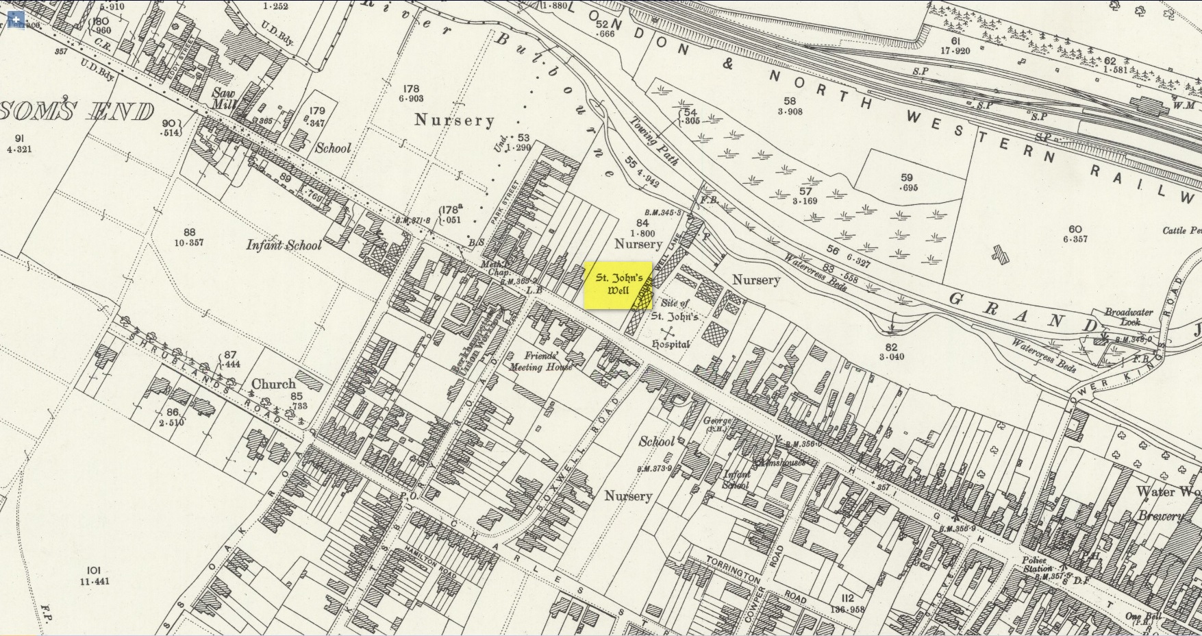
The well was still visible up until the 1930s, when its waters ran down a shallow channel along St John Well’s Lane, but then a shop was built above the site and the well has been lost forever.
References:
- Bord, Janet & Colin, Sacred Waters, Granada: London 1985.
- Chauncy, Henry, The Historical Antiquities of Hertfordshire – volume 2, J.M. Mullinger: Bishops Stortford 1826.
- Cobb, John W., Two Lectures on the History and Antiquities of Berkhamsted, Nichols & Son: London 1883.
- Fry, Dora, “St. John’s Well,” in Hertfordshire Countryside, volume 8, 1954.
- Harte, Jeremy, English Holy Wells – volume 2, Heart of Albion press: Wymeswold 2008.
- Jones-Baker, Doris, Old Hertfordshire Calendar, Phillimore: London 1974.
- Jones-Baker, Doris, The Folklore of Hertfordshire, B.T. Batsford: London 1977.
- Page, William (ed.), Victoria History of the County of Hertford – volume 2, Archibald Constable: London 1908.
- Salmon, N., The History of Hertfordshire; Describing the County and its Monuments, London 1728.
Acknowledgements: Huge thanks for use of the Ordnance Survey map in this site profile, reproduced with the kind permission of the National Library of Scotland.
© Paul Bennett, The Northern Antiquarian