Stone Circle (destroyed): OS Grid Reference – SU 161 684
Also Known as:
Clatford Stone Circle
Archaeology & History
John Aubrey’s early drawing (soz about the crap quality)
Also known as the Clatford Circle, it was described by both of the old pioneers, John Aubrey and William Stukeley: Aubrey saying the monument could be found “in a lane leading from Kennet to Marlborough… (consisting) of eight huge large stones, roughly hewn… in a circle, which never could be by chance.” Will Stukeley reckoned that four other stones close by, “may possibly have been the beginning of an avenue.” We might never know for sure.
The local Avebury authority, Pete Glastonbury, showed us a spot which he thinks may have been the where the circle stood, and where a couple of decent-looking stones lay by the side of the track that could have once been a part of this circle. It looked as good a contender as anything else. Has all trace of this monument truly been destroyed?
References:
Burl, Aubrey, Prehistoric Avebury, Yale University Press 2002.
When Pete Glastonbury brought us here, we walked east out of the Avebury stone circle and up the Wessex Ridgeway track. When you hit the “crossroads” at the top of the rise a mile along, go across the stile into the grasslands for a few hundred yards till you hit the obviously-named “Gallops” racecourse-looking stretch. Walk down for a few hundred yards till you hit a footpath on your left that takes you across and down grasslands that takes you slowly into the valley bottom. You’re damn close!
Otherwise (and I aint done this route!), walk up the footpath straight north from Clatford village, up the small valley for about 1km. You’ll eventually see this great stone heap in the field on your left!
Archaeology & History
I was brought here one fine day last year in the company of PeteG (our guide for the day), Geoff, June and Mikki Potts. Twas a fine foray exploring the various prehistoric sites on the lands east of Avebury — but it was my very first venture to this site, the Devil’s Den — and a grand one it was indeed! Standing close to the small valley bottom a couple of miles east of the great stone circle, this megalithic monument is thought to be neolithic in origin.
When H.J. Massingham (1926) came here, the day and spirit of the place must have felt fine, as he described,
“its three uprights and capstone stand forlornly in the midst of an alien sea of ploughland swinging its umber ripples to the foot of a stone isle, drifted nearly four thousand years from the happy potencies of its past.”
And, on many good times here no doubt, for many people, such feelings still hold…
A.C. Smith’s Devil’s DenColt Hoare’s Devil’s Den
It was described by the President for the Council of British Archaeology, Paul Thomas (1976), “as a setting of four sarsen uprights with a capstone”, whereby four uprights have not been noticed here since very early times. Not sure how old he was though! Today the very large capstone weighing upwards of 20 tons rests gently upon just two very bulky upright monoliths. A third is laid amidst the great tomb , overgrown and sleepy, touching one of the two uprights….
The cromlech itself seems to have once been part of a lengthy mound that was covered in earth, “about 230ft long and 120ft broad, now virtually removed by ploughing.” On top of the great capstone are at least two cup-markings: one of them with a possible oval-shaped line carved out onto the edge of the rock (similar to the C-shaped carving on the nearby Fyfield Down cup-marked stone), but this needs looking at in various lights so we can ascertain whether it has a geological or artificial origin.
Stukeley’s Devil’s Den
Suggested by Edwin Kempson (1953) and also by Aubrey Burl (2002) and other dialect and place-name students to have originally been called Dillion Dene — “the boundary marker in the valley” — this collapsed chambered tomb has had many literary visitors, from William Stukeley onwards. When the reverend Smith wrote his great tome in 1885, he gave an assessment of those who came before him, saying:
“This is a noble specimen of the Kistvaen: it stands erect in its original position, only denuded of the mound of earth which, I venture to say (on the authority of the Rev. W.C. Lukis and others best acquainted with these remains) at one time invariably covered them: and this massive erection of ponderous stones is known as the ‘Devil’s Den’, and offers an exceedingly fine specimen of the kistvaen to those who have not made the acquaintance of these ancient sepulchres in other counties. It is not only perfect in condition, but of very grand dimensions; moreover, it is well known to everybody who takes the slightest interest in Wiltshire antiquities… Stukeley says very little of this kistvaen, though he gives several plates of it (in Abury Described), his only remark being: “An eminent work of this sort in Clatford Bottom, between Abury and Marlborough.” Sir R. Hoare (in Ancient Wiltshire, North) is more enthusiastic, he says: “From Marlborough I proceed along the turnpike road as far as the Swan public house in the parish of Clatford, and then diverge into the fields on the right, where, in a retired valley amongst the hills, is a most beautiful and well-preserved kistvaen, vulgarly call’d the ‘Devil’s Den.’ It has been erroneously described as a cromlech. From the elevated ground on which this stone monument is placed, it is evident that it was intended as a aprt annexed to the sepulchral mound, and erected probably at the east end of it, according to the usual custom of primitive times.””
In more recent years, Terence Meaden (1999) has suggested that the Devil’s Den may actually have been a simple cromlech and never had any covering mound of earth. In his Secrets of the Avebury Stones he described how,
“The vertical megaliths must have been set up firmly first and then, quite possibly, a mound was raised outside and between them. A very long ramp could have been built next, along which the capstone was dragged until it lay on top of the vertical monoliths, after which both mound and ramp would be removed as far as possible. Such an operation, if correct, would explain why the stones of Devil’s Den now stand on an obviously artificial eminence; and why the much-spread remains of a long mound oriented NW-SE, about 70 metres (230 feet) long and 40 metres (130 feet) broad, were seen and described by Passmore in 1922. One should not necessarily assume that the stones are the remains of a chambered long barrow, although they might be.”
And you’ve gotta say that unless we have hardcore evidence to the contrary, his summary is quite possible. However, it seems here that Meaden has simply utilised this logic to enable him to posit another reason — a “good one” he calls it — for this suggestion, i.e.,
“its capstone seems to have profiles of heads carved upon two, perhaps three of its sides; suggesting that, if the art was meant to be seen, the capstone was never covered with earth.”
Devils Den on 1889 map
Unfortunately however, these possible “carved heads” on the sides of the capstone more typify Rorscharch responses to natural geological shapes scattering rocks all over the planet. Up North, if we were to attempt this sorta suggestion, we’d have millions of such carved heads popping up all over the place. It’s a nice idea, but somewhat unlikely.
Folklore
The old dowser Guy Underwood (1977) was renowned for locating water lines* in and around many of England’s prehistoric sites, and the same pattern was recorded here. He told that the Devil’s Den marked the site of a blind spring “of exceptional importance.” He continued:
“The Devil’s Den dolmen marks the source of a multiple water line which forms a maze, marked by stones, about 200 yards to the northwest. It terminates at a well, where two tracks cross about a mile further west. This site is likely to have had special sanctity and would be interesting to excavate.”
Whilst the importance of water was understandable in ancient days, some other folklore attributes derive from quite different ingredients. The common theme of “immovability” is found here, as described by reverend Smith (1885) again who, amidst other peculiarities, told the following:
“There are various traditions connected with it. I was told some years since, by an old man hoeing turnips near, that if anybody mounted to the top of it, he might shake it in one particular part. I do not know whether this is the case or not, though it is not unusual where the capstone is upheld by only three supporters. But another labourer whom I once interrogated informed me that nobody could ever pull off the capstone; that many had tried to do so without success; and that on one occasion twelve white oxen were provided with new harness, and set to pull it off, but the harness all fell to pieces immediately! As my informant evidently thought very seriously of this, and considered it the work of enchantment, I found it was not a matter for trifling to his honest but superstitious mind; and he remained perfectly unconvinced by all the arguments with which I tried to shake his credulity.”
References:
Burl, Aubrey, Prehistoric Avebury, Yale University Press 2002.
Goddard, E., “The Devil’s Den, Manton, Wiltshire,” in The Antiquaries Journal, volume 2, no.1, January 1922.
Gomme, Alice B., ‘Folklore Scraps from Several Localities’, in Folklore, 20:1, 1909.
Grinsell, Leslie V., Folklore of Prehistoric Sites in Britain, David & Charles: London 1976.
Kempson, E.G.H., “The Devil’s Den,” in Wiltshire Archaeology & Natural History Magazine, 55, 1953.
Massingham, H.J., Downland Man, Jonathan Cape: London 1926.
Meaden, Terence, The Secrets of the Avebury Stones, Souvenir Press: London 1999.
Smith, A.C., A Guide to the British and Roman Antiquities of the North Wiltshire Downs, Wiltshire Archaeological & Natural History Society 1885.
Thomas, Nicholas, Guide to Prehistoric England, Batsford: London 1976.
Underwood, Guy, The Pattern of the Past, Abacus: London 1977.
Wright, Joseph, English Dialect Dictionary – volume 2, Henry Frowde: London 1898.
* Those people who allege they can dowse will always find water in their first few months, if not years, of sensitivity. There is a pattern nowadays of people using dowsing tools and, when the rods cross (or whichever accessory they get their reactions from), they allege they are connecting with unknown energies, ley lines and other such items; but this is simply incorrect. The primary dowsing response is water (life-blood) and it takes much practice over long periods of time to even begin isolating leys or other occult phenomena.
Follow the directions to reach the Devil’s Den, a half-mile north of Clatford up the footpath towards the Fyfield Down cup-marked rock. You can’t miss it! The cup-markings are on the top of the capstone.
Archaeology & History
First described and illustrated by local historian and photographer, Pete Glastonbury, as far as I’m aware these cup-markings have not previously been included in any of Wiltshire’s archaeological surveys (that can’t be, surely?). The only reference I’ve found — not untypically — is from one of the early editions of the english Folklore Journal.
…and again!Devil’s Den cup-markings
At least two well-defined cups stand out on the top of the capstone. Each of them have ‘cracks’ running out of them, with the easternmost one of them (closer to the edge) turning into a channel which runs upwards on the stone, before then leading down off the edge of the rock. Each cup-mark is very clear, about two inches across and about a half-inch deep.
Archaeologists can check these cups out and work out for themselves whether they’re natural or not. They’re far more qualified than I on such matters and may be able ascertain other faint remarks on the stone. The proximity of the nearby Fyfield Down cup-marked rock, several hundred yards to the north, shows that such petroglyphs can be found in this region. Although we cannot expect many examples of rock art in this area (the rock’s damn tough and takes some burrowing into), it is likely that more carvings await discovery.
Folklore
The capstone on which these cup-markings are seen was told to be immovable and had lore said of it akin to that found at the great Whispering Knights, near the Rollright Stones. But the main piece of lore describes the cups quite specifically. In an article by Alice Gomme (1909), she told that:
“if anyone pours water into any of the natural cup-shaped cavities on the top stone at midnight, it will always be found in the morning to be gone, drunk by a thirst-tormented fiend.”
The tale is later repeated in Kathleen Wiltshire’s (1975) survey, where she too mentions the cup-marking (though only one), saying that,
“if a person pours water into the natural cup-shaped cavity on the top stone at midnight it will always be found to be gone in the morning — drunk by the devil.”
This folklore motif — repeated in Grinsell’s (1976) text — is found at rock-art sites in a number of the northern counties, where milk has been poured into the cup-markings (some of which were known as ‘cat stones’) and left overnight for the spirits to drink. In the case we have recorded at Devil’s Den, the spirit of the place seems to have been demonized, as is common.
Miss Gomme (1909) also reported the curious ingredient that the spirit of a white rabbit with glowing eyes would appear on the capstone at midnight and help the devil demolish the site with the aid of eight oxen! On this latter matter, I am duly informed by one-in-the-know that, to “those of us that know the locals and their humour, we just know this tale was made up for a visiting townie!”
References:
Gomme, Alice B., ‘Folklore Scraps from Several Localities’, in Folklore Journal, 20:1, 1909.
Grinsell, Leslie V., Folklore of Prehistoric Sites in Britain, David & Charles: London 1976.
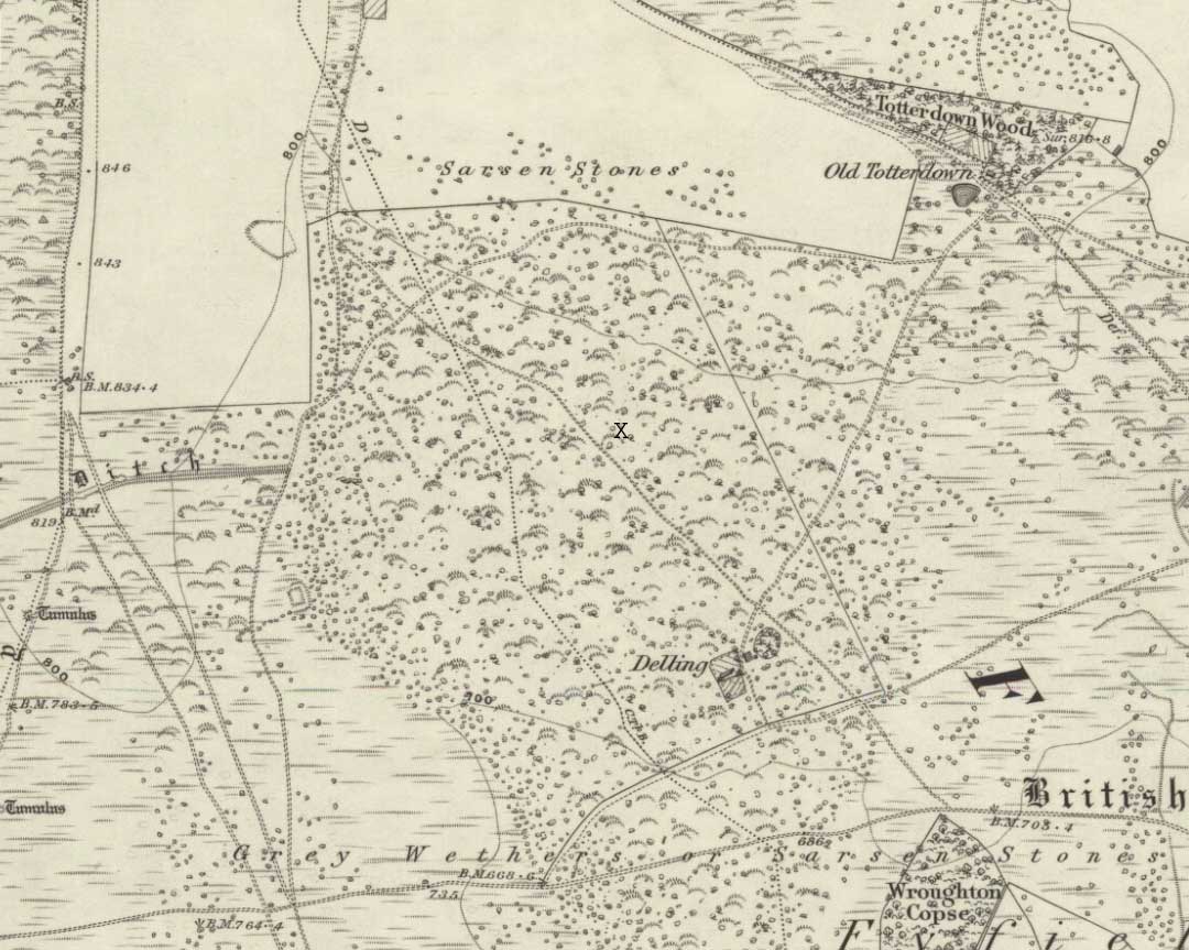
We were fortunate and taken here by the renowned local megalith authority, Pete Glastonbury – but without Pete’s help you might be ambling here and there for quite a while. It’s on the eastern side of The Ridgeway, down the slope past the stone known as The Polisher, across the flatland sea of many rocks until it begins rising again a few hundred yards east. Where a long straight embankment rises up a few feet (a boundary line), the rock’s just a few yards above it. Walk back and forth around here and you’ll eventually find it!
Archaeology & History
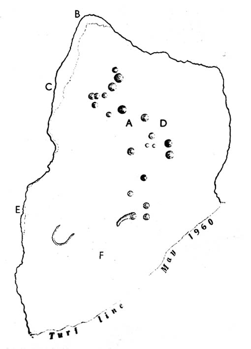
Lacaille’s 1962 sketch of the carving
Archaeologist A.D. Lacaille (1962) appears to have been the first person to have written about this little-known site, describing it as being “between the south-western corner of Totterdown Wood and Delling Cottage.” Here is what he described as, “a cluster of unmistakably artificial and mostly well-preserved cup-markings on the smooth south-easterly sloping surface of a recumbent sarsen.”
And from the photos accompanying Lacaille’s article, it obviously looked a decent carving as well — and so it has transpired. Lacaille (1963) briefly mentioned the carving again a year later in his lengthier essay on the nearby Polisher Stone up the slope a few hundred yards away. But then Wiltshire’s only known cup-marked stone was all-but ignored by archaeologists and left in the literary wilderness until, years later when rock art became a fad in such circles, regional archaeologists Pete Fowler & Ian Blackwell (1998) described the carving as “a cluster of several round depressions…each about two inches across”; though incorrectly ascribed it as the “southernmost example” of cup-marked stones outside of Cornwall.¹ Another rock-art student known as Mr Hobson, following his excursion to the site with the regional authority Pete Glastonbury, wrote:
“The cups themselves are very smoothed out, and fit the bill from the drawing. The horseshoe is very evident, as is the ‘slug’ mark, possibly a half-finished groove from one of the cups near the horseshoe. There are also some angular, yet serpentine (?) grooves at turf level on the south side of the stone. These look like they might be enhanced natural marks in places.”
The rock itself isn’t in its original position, having been moved from another point very close by (probably only yards away). It is sited on the edge of an old boundary line — which made me wonder whether the ‘U’- or ‘C’-shaped ingredient in the carving was a later addition, perhaps of one of the old land-owners hereabouts. The cups however, seem typical of the thousands that we find in northern Britain.
The isolation of this carving is rather anomalous. Others should be in the area but archaeo-records are silent (though the majority of Wessex archaeologists are academically illiterate when it comes to identifying such carvings). The carving may simply be the product of nomadic northerners, showing what their tribes do ‘up North’, so to speak. However, considering the tough nature of southern sarsen stones, it’d have taken ages to etch just this one stone. You can visualise it quite easily: southern tribal folk looking on, somewhat perplexed, as a northern traveller tried to convey what they etch on their stones in the northern lands, only to struggle like hell with cup-marks they’d do with ease on the softer rocks of their homelands. Wessex tribes-folk may have watched, seen the trouble their traveller had over such inane and (perhaps) meaningless carvings, and didn’t see the mythic point s/he was trying to convey…
Curious ‘U’ or ‘C’-shaped feature
Or maybe not!
The lesson with rock-art tends to be simple: where there’s one carving, others are nearby. The rule aint 100% of course — but when we were here the other day I was wanting to dart here, there and everywhere to check the many thousands of outcrop rocks that scatter this entire area. Us rock-art nuts tend to do things like that. It’s a madness that afflicts…
There were one or two stones with ‘possible’ single cup-markings on them, but I wasn’t going to start adding them to any catalogues. They were far too questionable. I was wanting something a bit more decent than that. And then, when Mikki, June, Pete, Geoff and I got to the collapsed long barrow known as the Devil’s Den a few hundred yards further down this rock-strewn sea of a valley, there was something with a bit more potential that we came across…
Folklore
In recent years this cup-marked stone has already attracted imaginative notions, with little foundation. Archaeologists Fowler & Blackwell (1998), in their otherwise fine book, think this carving was related to goddess worship, describing how,
“On Dillion Down…the Great Mother’s help was permanently invoked by patiently indenting a special stone with symbols of her potency.”
Adding that this “was a new idea brought in from the North, and Fyfield was the only place to have such a stone.” Weird! I could’ve sworn there were plenty of other rocks between here and there!
References:
Fowler, Peter J., Landscape Plotted and Pieced: Landscape History and Local Archaeology in Fyfield and Overton, Society of Antiquaries London 2000.
Fowler, Peter & Blackwell, Ian, The Landscape of Lettice Sweetapple, Tempus: Stroud 1998.
Lacaille, A.D., ‘A Cup-Marked Sarsen near Marlborough, Wiltshire,’ in Archaeological Newsletter 7:6, 1962.
¹ Along with the cup-markings atop of Devil’s Den a few hundred yards to the south, across in Somerset we had the Pool Farm example; there are a number of examples in Dorset, including the Badbury Rings carving; plus others in Devon, etc.


")
")