Until we’ve isolated this site, it’s difficult to suggest an age for it. It’s an all-but forgotten grave of some sort, last mentioned by John Clough (1886) in his rare work on Steeton township. Although the folklore indicates some medieval date here, the site may have been a prehistoric tomb, as it was located in the same valley a mile east of another little-known prehistoric burial at Crosshills. Mr Clough wrote the following of the site:
“Until AD 1790 the road to Kildwick would be down Pot Lane and past ‘The Lion’. Near a field, now called Nanny Grave Hill; there were four land ends; there are three lane ends yet; there was what i’s called Devil’s Lane, the lanes towards Eastburn and Steeton, and Wood Street… The junction of these four lane ends is the scene of one of Steeton’s tragedies. At this place is buried a suicide called Nanny, with “a stake in her inside.” Some people point out the mound under which she’s buried. When the suicide took place isn’t known, but it would certainly not occur later than the 17th century.”
But there are no records telling of the said ‘nanny’ and her death, nor archaeological accounts of any excavations hereby. The epithet nanny is sometimes used in northern counties to mean a witch, and although we have no remaining lore telling of such a character, the old name Devil’s Lane certainly infers some pre-christian or supernatural history hereby, common to many ancient burial mounds throughout Britain and across the world. Also a burial at an old crossroads is another heathen indicator; and the legend of the body having “a stake in her inside” is highly suggestive of further archaic death rituals, fixing the spirit of the dead at the site to prevent transmigration of any form, effectively ending the lineage of shaman or other heathen priestess. Any further information about this site would be most welcome.
References:
Clough, John, History of Steeton, S. Billows: Keighley 1886.
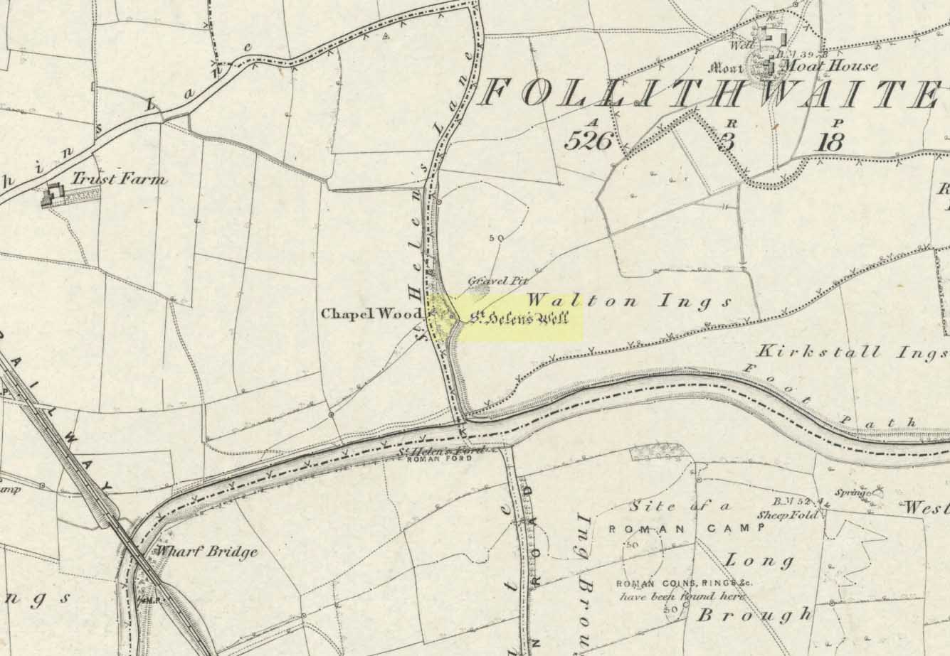
The well is all dried up today, but its remains are about 200 yards north of the river Wharfe. Sam Brewster (1980) told the easiest way to find it: “To get there from Thorp Arch you take the trackway that goes to the south of the church and follow this until you are walking alongside the river; eventually you will come to a barrier of barbed wire near some old disused water-works; get under or over this barrier and turn 90 degrees to your left, following the barbed wire until you come to a wood, the other side of the barbed wire; go into the wood and turn right; keep exploring near the edge of the wood until you find a tree under which is a hollow which used to be St. Helen’s Well.” Once here you can see where the water used to flow down a narrow channel and under a little bridge.
Archaeology & History
Carved cross remains found near St Helen’s Well
This ancient and well-known healing spring is shown on early OS-maps emerging a short distance north of the River Wharfe besides St. Helen’s Beck in Chapel Wood, adjacent to the Kirkstall Ing or field. In the western fields close by was once an ancient chapel and, closer to the holy well, once “stood St. Helen’s (or St. Helena’s) Cross, which is somewhat crudely represented in Dr. Whitaker’s History of Craven“, (Speight 1902), illustrated here.
This well possesses a prodigious occult history yet is curiously absent from most studies on the subject. The place is said to have been a respected holy site that was venerated long before the Romans arrived here. Found at a place called the Rudgate — but known locally as St. Helen’s Ford — it is also said to be haunted. Angela Smith (n.d.) considers the traditions surrounding the well to be pre-Roman, and the curative waters would certainly have been known of at the time of their occupation here,
“because it lies at the side of Roman road No.280, just north of where it crosses the River Wharfe at St. Helen’s Ford, leading to the Roman fort at Newton Kyme.”
St Helens Well in 1900
Several species of psychoactive plants grow adjacent to the well, which are thought by Phillips, (1976) Devereux (1992) and I as serving ritual shamanic purposes. The likelihood is more so than not. The oracular nature of the site which R.C. Hope (1893) and others have described here is particularly interesting: in traditions the world over, oracles were often consulted after the ingestion or use of sacred plants, such as are found here.
Due to the sacred nature of this spring and its importance in local folklore and history, it should be recovered from its present state. The fact that this place was highly important as a ritual and sacred site to christians, pagans, Romans and peasants alike, and now hides all-but-lost and forgotten is a disgrace.
Folklore
A fascinating tale hangs over this still-revered holy well which legend tells had a chapel standing adjacent, dedicated to Helen in the 7th century – although no trace of it is visible today. Local historian Edmund Bogg (1904) recounted how a local sexton told of “padfoots and barguests and ‘that grim foul beast with clanking chain’ which on dark nights kept its vigil” near St.Helen’s Well. Padfoots and barguests are Yorkshire names for spectral black dogs, said to be bringers of death and misfortune (they are one of several remaining folk-ingredients from the Underworld myths in British shamanism).
St Helen’s Well, c.1935St Helens Well in 1934
Folklorist Guy Ragland Phillips (1976), referring to an article in The Dalesman in 1971, told how a Mrs Dorothy Tate as a young girl used to visit the site and would tie pieces of rag on the bushes aside the place as grateful offerings to the spirit of the well. She said however, that she had gone about doing this in the wrong way, as according to tradition such offerings are to be done secretly. The article showed a photograph of Mrs Tate (from 1908) tying one of the memaws to the wych-elm tree overhanging the old spring.
People visited the well – probably on August 18 – to divine the future with the oracle which Hope (1893) described as being here, always in the dead of night without being seen, leaving before sunrise. It has been visited by thousands of people over the centuries, with gifts of rag-hangings, pins and other memaws. Such offerings continue even to this day. When Harry Speight (1902) visited St. Helen’s Well at the turn of the century, he related how as many as forty or fifty hangings would be left at any one time on the branches of the trees. He wrote:
“The water is beautifully soft and clear, and in former times was much resorted to as a specific for sore or weak eyes. There are two other springs close by, which were also held to be sacred, but they do not bear any particular dedications. An old plantation a little north of the well is known as Chapel Wood, which commemorates St. Helen’s chapel and the ancient church at Bilton, three miles further north, and about a mile to the east of the Roman Rudgate, is also dedicated to St. Helen.”
A few years before Speight’s visit here, Dr Fred Lees and the botanist, Robert Baines, visited St. Helen’s Well, and wrote similarly of the lore and memaws they found there:
“There are veritably hundreds of these bedizenings affixed and removed surreptitiously (probably before sunrise), according to an unwritten law, for none are ever caught in the act. And yet during the summer months a careful observer may detect almost weekly evidence of a shy communicant with the ghostly genius of someone¾country maid or her dumb shy swain. What murmured litany (if any) had to be said is lost; most likely nothing more was necessary than the unspoken wish…Pieced together and codified, fact and heresay testify as follows: ‘The visitor to the grove, before rise of sun, has to face the tree [a wych-elm overhanging the well] to detach from his or her own person some garment, to dip it in the well, and having knotted or whilst hanging the fragment to any convenient twig…is to breathe a ‘wish’ telling no-one what that wish may be; these conditions strictly observed, what is desired shall come to pass.'” (in Phillips, 1976)
When the archaeologist C.N. Bromehead (1935) and geologist J.V. Stephens came to the site in the 1930s, despite the fall of the well, he was surprised to find local peasants still respecting the spirits of the site, reporting:
“There is now no well or visible spring, but from the position at the lower margin of a gravel terrace it is obvious that water would be obtained by digging a few feet; a small stream flows just east of the site… It is curious that the hanging of rags should survive when the actual well has vanished, but the writer has visited the spot many times in the last seven years and there are always plenty of obviously recent additions. The custom is to stand facing the well (i.e., due west), preferably after sunset, wish, and then attach something torn from one’s clothing either to the big tree — wych elm — or to any of the bushes. Probably the custom is largely maintained by vagrants who frequently camp in the wood, but it also has its attraction for courting couples from the neighbouring villages!”
Such offerings at the site of St. Helen’s Well are still left by locals and some of the plastic pagans, who tie pieces of artificial material to the remnants of the wych-elm and other trees, which actually pollutes the Earth and kills the spirit here. Whilst the intent may be good, please, if you’re gonna leave offerings here, make sure that the rags you leave are totally biodegradable. The magical effectiveness of your intent is almost worthless if the material left is toxic to the environment and will certainly have a wholly negative effect on the spirit of the placehere. Please consider this to ensure the sacred nature of the site.
…to be continued…
References:
Bogg, Edmund, Lower Wharfeland, the Old City of York and the Ainsty, James Miles: Leeds 1904.
Brewster, Sam, ‘St. Helen’s Well,’ in Wind & Water 1:4, 1980.
Bromehead, C.N., ‘Rag Wells,’ in Antiquity IX, March 1935.
A couple of miles west of the Hutton Moor henge we find the faint remans of another large prehistoric ritual site, soon to fade from existence. Although the local farmer was aware of the existence of this ‘earth circle’ in his fields in the 1940s, the place wasn’t officially catalogued until Prof. J.K. St. Joseph noticed it following an aerial survey of the region in 1951 (from whence the aerial photo comes). Today sadly, much of the site has succumbed to the ravages of excessive agricultural activity and is all but destroyed. Faint traces of it can be seen at ground level when the crops are down, but most of it’s gone. Even when first discovered, the remains were sparse, as the photo (below) shows.
Early aerial photo of Nunwick hengeMr Dymond’s early ground- plan (from YAJ, 1963)
Neolithic in origin, the site was excavated in 1961 by D.P. Dymond who explored a portion of the bank and ditch and stripped a small internal section. His findings showed it to be structurally similar to the other henges in the area and of considerable size. Measuring 690 feet across, the henge spread across two fields and was bisected by a hedge and farm track. When Dymond first explored the henge he reported how the surrounding bank was between 1-3 feet high and had been spread to a width of 120 feet; the ditch was just a couple of feet deep; and the original ‘entrances’ north and south of the ring were still just visible as “slight depressions in the bank.”
The Nunwick henge was classed as a Class II henge (after Atkinson). Five feet smaller than the Thornborough (south) Henge, its entrances are close to north-south. The River Ure is less than half-a-mile from the site and the presence of other streams close by further emphasizes water as a potentially relevant ingredient. This element seems to have had some factor in the structure of the henge as there were many water-worn stones found in the embankment, which probably came from the nearby river. However, like many henges, very few remains were discovered upon excavation here, as Mr Dymond’s (1963) account tells:
“The 1961 Excavation was restricted to a single long section through the northwest side of the circle, to examine the structural details of the bank and ditch, and to confirm the apparent absence of an outer ditch.
“A small area, 22ft square, was stripped inside the ditch to test for pits or postholes, but nothing was found in the sandy silt which covers the gravel deposits. Air-photographs gave no indication of a former presence of standing features within the enclosure.
“The ditch was found to be 45ft wide and 5ft 10in deep, with a wide, shallow profile. Allowing for the destruction by ploughing of the upper edges of the ditch, the orignal dimensions of the ditch were undoubtedly greater. The edges of the ditch were not easy to see in excavation, as the fill was similar to the natural gravel subsoil and some slumping had occurred on the loose gravel faces. The ditch had apparently silted slowly with material washed in from both sides. At an early stage in the silting, when the accumulation was about 1ft, there had been occupation in a limited area, revealed by a circular patch of burnt material, 10ft in diameter, which contained many split pot-boilers reddened by fire.
“Between the ditch and bank there was originally a berm of 30ft. On the surface, this is not visible as the bank shades imperceptibly into the ditch. The bank was originally about 60ft wide, but is now considerably spread on both sides. In the 1961 section the bank survived only 18in high; this was sufficient, however, to show clear traces of tip-lines and the interleaving of loads. The lowest two inches of bank material consist partly of turf… Under the bank, the original turf-line was visible as a purple-black line, 1-3in thick, with traces of a weakly developed iron-pan. In the original composition on the bank there were many water-worn stones (3-9in across), now in the outer spread and in the bottom of the ditch; on the northern side of the circle where the bank is best preserved there are large quantities of these stones on the plough soil. Quarried from the bottom of the ditch, where the aggregate of the gravels was much larger, these stones were probably on the top of the bank.
“Two square were dug outside the bank, on the line of the section to text for an outer ditch. This confirmed the evidence of air-photographs that no such ditch existed. Of the six henges in the Ripon area, Nunwick is therefore the only one without two ditches.
“No dating evidence was found in the 1961 excavation. Three worked flints however, were picked up from the plough soil of the southwestern field near the henge. They consist of two waste flakes and a small flake scraper of opaque brown flint.”
Archaeologists and ley hunters alike have described how the Nunwick Henge aligns with the three prominent Thornborough Henges to the north. Significant…?
References:
Dymond, D.P., “The Henge Monument at Nunwick, near Ripon – 1961 Excavation,” in Yorkshire Archaeological Journal, part 161 (volume 41), 1963.
Wainwright, Geoffrey J., “A Review of Henge Monuments in the Light of Recent Research,” in Proceedings of the Prehistoric Society, volume 35, 1969.
Get yourself to the impressive multi-ringed Greystone Allotment carving, then walk to the copse of trees close by and bear left, following the edge of the fence along and following it when it turns down at right-angles, until you hit the bottom corner of the trees, where a path cuts in front of you. From the bottom corner of the trees walk 25-30 yards diagonally away from the trees. It’s under your nose somewhere damn close!
Archaeology & History
This is another archetypal cup-and-ring stone, similar in size and design to the recently discovered Slade (02) carving on Blubberhouses Moor, just over 4 miles (6.5 km) northwest (followers of Alexander Thom’s megalithic inch theory might be interested in assessing the measure of these two). It is one of number clustered in and around this small grass ‘moorland’ region, where a number of carvings perished in the 19th century. Thankfully this one survived. Boughey & Vickerman’s (2003) brief notes on the stone tell:
“Small, rough grit rough of regular oblong shape set very low in turf. Two cups, each with a ring, and connected by a groove.”
On a recent visit to see this carving, Danny Tiernan, Paul Hornby, James Elkington and I were unable to locate it. The carving may well have been destroyed, or moved. If anyone is aware of what has happened to this petroglyph, please let us know. We will be contacting the local authorities to see if any explanation is forthcoming from them.
References:
Boughey, Keith & Vickerman, E.A., Prehistoric Rock Art of the West Riding, West Yorkshire Archaeology Service 2003.
From the Chester ring road head into north Wales along the coast road (A548) from Connah’s Quay for about 13 miles taking you through Flint. After 12 miles turn left into Holywell town (Treffynnon). At the western end of the town go down the Greenfield-Mostyn road back towards the A584 taking you down a hill. After 500 hundred yards you arrive at the holy well/shrine and pilgrimage centre on the right-hand side; there is parking on the opposite side of the road. There is a small entrance fee, but as well as the famous healing well and bathing pool, they have a gift shop, toilet facilities and a late medieval/Gothic two-storey structure that is built over the polygonal, vaulted well chamber, whilst at the side (at the corner of the hill) stands another Gothic chapel from 1500.
History and Legend
According to the well known legend, a young Welsh girl called Winefride or Gwenfrewi, was the daughter of patrician parents, Thenith (Thewyth) and Gwenlo, who lived at Bryn-y-Castell (Treffynnon) at the beginning of the 7th century AD. She was a very religious girl who was known for her kindness and charities to people in the area that was then called Tegeingl (after the Decengle tribe). Winefride grew up to be a very beautiful young woman which troubled her because she had no wish to marry, only to live a life of chastity and serve God as only she knew how.
St. Winefrides Well 1742
One day a local chieftain from Hawarden (Penarlag) called Caradoc ap Alyn came hunting in the area. He became very thirsty so stopped off at the house where Winefride lived with her parents. However, on this particular day her parents were attending the local church where St Beuno, her uncle, was conducting a service. Prince Caradoc soon began to seduce her so she ran to the church but with the prince in hot pursuit. When he caught up with poor Winefride, she again resisted him so he took his sword and beheaded her. Her severed head fell to the ground and rolled down a hill and where it came to rest a spring of water gushed forth from the ground. Her parents and uncle came rushing out of the church at which point St Beuno cursed the evil prince, who was calmly wiping blood from his sword, causing him to sink into the ground — never to be seen again. St. Beuno then placed the severed head back into place, restoring Winifred to life again but leaving her with a thin scar round her neck.
Later, Winifred was entrusted for her education to St Beuno whom sent her to various holy men including St. Elerius at Gwytherin near Llanwrst. Here she became abbess of a convent that had been founded by Elerius, with his mother St. Theonia as first abbess; and it was here for the next 40 years that Winifred lived out her life. She was said to have died at Gwytherin in either 65o or 670 AD. Her body was first interred in the churchyard there, however in 1138 her relics were transferred to Shrewsbury Abbey. Sadly however, her shrine there was destroyed in the 16th century and now only a few relics remain with a finger-bone being housed at a convent in Holywell.
Mythology and Folklore
St. Winefrides Well 1750
The holy well and shrine of St. Winifred at Holywell became a place of pilgrimage during the middle-ages and many miracles of healing were wrought there. The sick were cured of infirmities of the legs and body; crutches were left at the well and many were cured of leprosy, eye complaints, loss of hearing, being not able to bear a child, mental illness, palsy and lung disorders etc. During the Reformation the holy well suffered much, but from the 17th century onwards pilgrims were returning to the holy place and, more recently it has become the Welsh Lourdes and still pilgrims come in droves from all over Wales and beyond. The vaulted Gothic structure covering the well shrine is richly carved with bosses depicting various characters including St Beuno, Earl Stanley, Lady Margaret Beaufort, biblical characters, animals and an abbot of Basingwerk abbey, but there is also much recent graffiti too. A tall statue of St Winefride looks down over the well while candles burn all around. In the larger bathing pool outside, a stone lies at one side — this is claimed to be where St. Beuno sat whilst teaching his young niece. Red stains on stones at the front of the well-basin were long taken to be the martyr’s bloodstains, but now these are thought to be iron oxide pigmentation on the lichens. Today the people still come either to bathe in the special pool, throw coins in the well, or fill bottles with holy water from a tap on the wall. Faith in miracles of healing is still much in evidence here and may it continue to be for many years to come. Everyone is welcome here, you don’t have to be a Roman Catholic!
References:
Bord, Janet & Colin, Sacred Waters, Paladin: London 1986.
David, Christopher, Saint Winefride’s Well – A History and Guide, Gomer Press: Llandysul 2002.
Edwards-Charles, Thomas, Saint Winefride and Her Well – The Historical Background, Holywell 1962.
Heath, Sidney, In the Steps of the Pilgrims, Rich & Cowan: London 1950.
Jones, Francis, The Holy Wells of Wales, University of Wales Press: Cardiff 1992.
Cowling’s 1946 ground-plan of a portion of the settlement
From Blubberhouses church by the crossroads, walk up the slope (south) as if you’re going to Askwith, for 100 yards or so, taking the track and footpath past the Manor House and onto the moor. Once you hit the moorland proper, take the footpath that bears left going down into heather and keep going till you hit the dead straight Roman Road path running west onto Blubberhouses Moor. Go on here for nearly a mile until you hit the valley stream with its Eagle Stone down on your left. Walk downstream, past the Eagle Stone, and cross over 100 yards down until you’re back on the level ground with the scatter of bracken and heather. You’re here!
Archaeology & History
On the other side of the stream a short distance southeast of the large cup-marked Eagle Stone is a curious site, first described by Eric Cowling (1946) as “a series of enclosures of varying size and roughly circular shape” which he ascribed as a Bronze Age settlement. Certainly we have a rather extensive scattered group of walled structures just as he described, but not all of the walling here seems typical of local Bronze Age constructions. Cowling suggested the remains to be “useful for protection, herding and for shelter,” though admitted archaeological excavation would be the best way to ascertain their specific nature. Such undertakings have yet to be done — and I wouldn’t hold your breath either.
Large section of wallingWalls of large circular structure
Although he described some of the walls here as nearly four-feet tall, when Graeme Chappell and I first ventured here in the winter of 1990, the walling wasn’t quite as high. There are a number of individual tall stones sat in the walls that stand three-feet tall, with some that have been cut and dressed in more historic times. Who did this and when is unknown. However, if we visited this place when all the vegetation has been cut and burnt back at the end of winter and early months of Spring — a fact not lost on Cowling when he first found this place — we would gain a much clearer picture of things here.
Some sections of lower walling above the streamside appear to be prehistoric in nature, but many other parts of the walled structures across this flatland plain have a much later look and feel about them, illustrating that the site may have been used well into post-medieval periods. This seems increasingly obvious where we find a number of the stones cut at sharp angles, with some having distinctive quarried grooves in them. However, I can find no historical records to verify this at present.
Hut circle remainsMedieval cut upright stone?
If we walk up the slight slope westwards however (before bracken and heath grow) there are more distinct prehistoric remains in the form of typical hut circles with low walls emerging from deep peatlands — although even these have been cut in one or two places by metal tools. My view of this little-known but large settlement arena is that we’re looking at a site initially built in the Bronze Age period, continuing to be used by local tribespeople throughout the Iron Age and, as the cut stones clearly show, was a village that was certainly made use of in the last millenium. But until someone comes along here and gives the site the attention it deserves, we’re not gonna know…
On the southern fringe of the copious walled structures we also find a very curious medicinal chalybeate spring that may have been of some importance to those who once lived hereby. A ‘standing stone’ and prehistoric cairn can also be seen close by.
References:
Cowling, E.T., Rombald’s Way: A Prehistory of Mid-Wharfedale, William Walker: Otley 1946.
Same directions as the Slade 01 carving. But once you reach the upstanding stone cairn on the rocky hill, walk 220 yards (less than 200m) WSW and look around. You’re damn close! If you find the large cup-marked Slade 03 carving, walk back east about 10-20 yards and you can’t really miss it!
Archaeology & History
This is just one of at least seven previously undiscovered carvings on this section of moorland – and it’s worth looking for! The two other names we gave it — ‘owl’ and ‘sunset’ — come from the very notable design: owl thanks to it having the appearance of large owl-like eyes, and sunset as the two cup-and-rings are etched on the western edge of the rock and, when we found it yesterday, the sun was setting (albeit to the NW) and the image prompted talks of setting suns, the land of the Dead and other such worldwide indigenous religious myths (Harvey 2000) — for without recourse to such ingredients, these carvings are vacuous archaeocentric museum pieces and nothing more. And this carving at least deserves much more than mere cataloguing! The internationally renowned archaeologist, O.G.S. Crawford (1957) would have entered this carving into his ‘eye’ and ‘owl’ motif, representative of goddesses or spirit-forms, as would Gimbutas. (1989)
…and from above
But this carving is archetypal, as we can see, though would appear to have no other etched features on the stone’s surface. It is very close (if not within) the prehistoric graveyard that is plainly evident 30-40 yards south in the burnt heather and would very likely have had some mythic relationship with the dead (a symbiosis we have found in many cup-and-rings). We plan further ventures here in the coming weeks in the hope that we can unearth other prehistoric remains.
References:
Crawford, O.G.S., The Eye Goddess, Phoenix House: London 1957.
Gimbutas, Marija, The Language of the Goddess, Harper Collins: New York 1989.
Harvey, Graham (ed.), Indigenous Religions, Cassell: London 2000.
From Appletreewick take the road east through Skyreholme and up Skyreholme Bank, bearing right at the fork in the tracks along the ancient Forest Road. Keep going till you cross the Larnshaw Beck and keep walking along the track until it runs wallside. Look over the wall and you’ll see this sloping-chair-shaped rock . You’re here!
Cup-Marked stone 431
Archaeology & History
Worth looking at if you’re visiting the Spiral Stone of Eller Edge field and its large associate, but otherwise this cup-marked stone is probably only for the purist rock-art mad-folk amongst us! There are what seem to be three decent cup-marks upon the sloping face of the rock here, with a possible pecked line to the side of two of them — though we have to consider the possibility that a geological condition is responsible for the easternmost cup. Described in the Boughey & Vickerman (2003) survey simply as:
“Large triangular rock of smooth gritstone, quarried at SE and sloping into ground at W and N. Three cups on top sloping face.”
Thirty yards up the slope along the wall-side you’ll find carving 432 with its single cup-marking.
References:
Boughey, Keith & Vickerman, E.A., Prehistoric Rock Art of the West Riding, WYAS: Wakefield 2003.
A slight walk to get here, but well worth it once you arrive! From Appletreewick, take the road east through Skyreholme and up Skyreholme Bank track, bearing right at the fork in the tracks along the ancient Forest Road. Keep going and after a couple of zigzags, you’ll cross the Larnshaw Beck. Keep walking along the track until it runs wallside — and here, go straight down the field for 75 yards (best climbing over the rickety wooden bridge by the stream 50 yards back and walking up). Although there are a number of other stones hereby, you can’t really miss this.
Archaeology & History
This carved stone and its close associates rest upon the green slopes overlooking the Blands Valley and further across upper Wharfedale and the lands beyond. The majestic Simon’s Seat rises on the nearby western slope and there in the greater distance, once more reaches the sacred hill of Pendle, with whom so many other ancient sites commune within our northern lands. It’s hard to say for sure that the Witch’s Hill was of little relevance to this and other stones, but only a fool would ignore the geomancer’s notes about this constant.
The carving here doesn’t give much clues in any direct sense either. We have an almost arrowhead-shaped rock with a dozen decent cup-marks or so cut along and near its western side; but the notable curiosity here is the small circular cluster of smaller cup-marks dotted in a near circular mass near the middle of the stone.
When Danny, Paul and I came here the other week, the initial impression of this cluster was one of a primitive solar symbol etched onto the rock; but the more we looked, the more it seemed that these small cups appeared to have been arranged in a very rough spiral lay-out. Now I know that spirals are damn rare items in rock art (especially in this part of the world), but the more we looked and then subsequently checked Boughey & Vickerman’s (2003) illustration, the more evident it became. Of course the ‘spiral’ could be merely fortuitous, but I’m not so sure misself. In discussing this with our field archaeologist later, he suggested getting a rubbing of this part of the stone on his next visit.
The stone was first described by the petroglyph explorer Stuart Feather (1964) and later described by the rock art students Boughey & Vickerman (2004), simply as:
“Large, rough grit rock with face sloping SE down into grass at N. About twenty cups to W, with three grooves at N corner and group of about twenty small cups at NE.”
A very intriguing carving. And if you visit here, make sure you check out carving 424 and others in the same field.
References:
Boughey, Keith & Vickerman, E.A., Prehistoric Rock Art of the West Riding, WYAS: Wakefield 2003.
John Dixon took a bunch of us on a pleasant amble here via the Fair Oak Circle site. From Fair Oak, go round the back of the farm and past the small cluster of hidden cottages, then bear right down the dirt-track and up the slope, then cross the field in front of you, going over the stile, following the footpath round the eastern edge of the slightly limestone New Laund Hill, and down again, thru the gate. From here, head diagonally across the field 150 yards towards the fencing at the woodland edge. Over the fence, into the trees, head halfway down the steep-ish slope and keep your eyes peeled for the rocky outcrop nearly halfway down. Alternatively, an easier way here is apparently from the Inn at Whitewell. Go across the river via the stepping stones (or wade!) and follow the footpath uphill towards a farm, where you’ll find a large steel gate on the left that leads into the woods. Here there are 2 paths: follow the higher of the two until it starts bearing to the right. Once here, look up the hill to the right you’ll see the rock outcrop. The caves are there!
Archaeology & History
Smaller Fairy Hole
There are at least 3 caves here, close to each other along the edge of the small footpath a few yards apart. The small rounded entrance of the northernmost one (photo, right) is reported by English Heritage to have had no human remains found therein, but further investigation is required here. The main cave however is where intriguing prehistoric finds were located. It appears that the entrance was deliberately built-up and blocked by stone walling a few yards inwards, giving the remains found therein a state of protection and sanctity. Writer and historian John Dixon (2004) tells what was in the cave:
“In 1946, an excavation was carried out on the site by the archaeologist Reginald C. Musson. In front of the larger cave is a flat platform on which evidence of Bronze Age daily life was found. This included animal bones, a pebble pounder (used to extract marrow from bones) and shards of a food vessel.
“All that survived of this tripartite collared urn was a large rim-collar shard, two fragments displaying neck/shoulder/body elements and five smaller pieces, probably from the base of the body. This is the only collared urn to have been found in a cave in Lancashire. Its tripartite Pennine form assigns it to an early Bronze Age date.”
The main Fairy HolePlan of cave chamber (after J.Dixon 2004)
The artificial walled entrance may not merely have been an ingredient giving sanctity to the place, but this could well have been a site for ritual shamanic practices, including prolonged rites of passage and death rituals (authentic ones, not the modern pagan nonsense). The ‘ritual death’ elements are highly probable here for, as John Michell (1975) told, caverns and crevasses are “most responsive to the necromancer’s invocation”. It’s geomancy, spirit association and the archaeological finds therein are strongly suggestive of this usage. (Eliade 1989, 1995; Maringer 1960, etc) Bearing this in mind, it is of some concern regarding the individual who thought it wise to spray-paint his name against the wall of the cave entrance (see photo); for many are those even in these days of shallow minds who fall prey to the car-crashes and creeping madness brought upon themselves by desecrating ancestral sites of ritual magick. It would be intriguing to keep a prolonged eye on the ‘Forsh’ who painted his ego in this cave of dead spirits…
Folklore
Not surprisingly, the little people hold legend here. Jessica Lofthouse (1946) found tales of these ancient peoples in several places close by, but at the Fairy Caves specifically,
“everyone knew that these little caves in the limestone at Whitewell were the homes of the little folk.”
…And in relation to the ingredient mentioned above, about ritual use of the cave in ancient times: are there any serious ritual magickians who’ve spent time working in this cave, overnight or longer, and who can let us know of their encounters here? (long shot, I know – but it’s worth asking, considering the probable use of the place) Or perhaps spontaneous encounters of other people here…
")
")

")


")


