Henge Monument: OS Grid Reference – SE 3229 7484
Archaeology & History
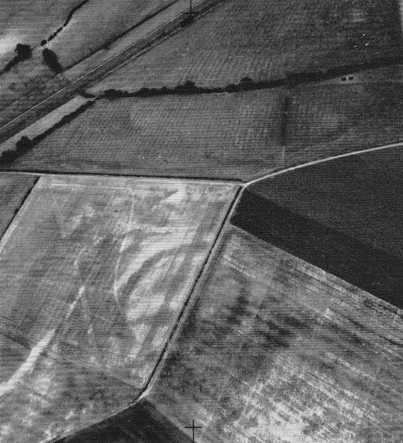
A couple of miles west of the Hutton Moor henge we find the faint remans of another large prehistoric ritual site, soon to fade from existence. Although the local farmer was aware of the existence of this ‘earth circle’ in his fields in the 1940s, the place wasn’t officially catalogued until Prof. J.K. St. Joseph noticed it following an aerial survey of the region in 1951 (from whence the aerial photo comes). Today sadly, much of the site has succumbed to the ravages of excessive agricultural activity and is all but destroyed. Faint traces of it can be seen at ground level when the crops are down, but most of it’s gone. Even when first discovered, the remains were sparse, as the photo (below) shows.


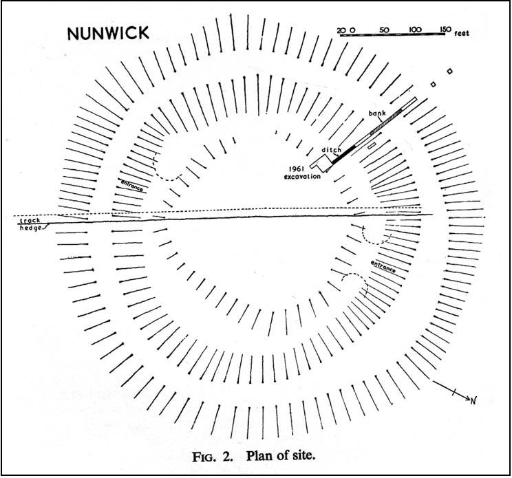
Neolithic in origin, the site was excavated in 1961 by D.P. Dymond who explored a portion of the bank and ditch and stripped a small internal section. His findings showed it to be structurally similar to the other henges in the area and of considerable size. Measuring 690 feet across, the henge spread across two fields and was bisected by a hedge and farm track. When Dymond first explored the henge he reported how the surrounding bank was between 1-3 feet high and had been spread to a width of 120 feet; the ditch was just a couple of feet deep; and the original ‘entrances’ north and south of the ring were still just visible as “slight depressions in the bank.”
The Nunwick henge was classed as a Class II henge (after Atkinson). Five feet smaller than the Thornborough (south) Henge, its entrances are close to north-south. The River Ure is less than half-a-mile from the site and the presence of other streams close by further emphasizes water as a potentially relevant ingredient. This element seems to have had some factor in the structure of the henge as there were many water-worn stones found in the embankment, which probably came from the nearby river. However, like many henges, very few remains were discovered upon excavation here, as Mr Dymond’s (1963) account tells:
“The 1961 Excavation was restricted to a single long section through the northwest side of the circle, to examine the structural details of the bank and ditch, and to confirm the apparent absence of an outer ditch.
“A small area, 22ft square, was stripped inside the ditch to test for pits or postholes, but nothing was found in the sandy silt which covers the gravel deposits. Air-photographs gave no indication of a former presence of standing features within the enclosure.
“The ditch was found to be 45ft wide and 5ft 10in deep, with a wide, shallow profile. Allowing for the destruction by ploughing of the upper edges of the ditch, the orignal dimensions of the ditch were undoubtedly greater. The edges of the ditch were not easy to see in excavation, as the fill was similar to the natural gravel subsoil and some slumping had occurred on the loose gravel faces. The ditch had apparently silted slowly with material washed in from both sides. At an early stage in the silting, when the accumulation was about 1ft, there had been occupation in a limited area, revealed by a circular patch of burnt material, 10ft in diameter, which contained many split pot-boilers reddened by fire.
“Between the ditch and bank there was originally a berm of 30ft. On the surface, this is not visible as the bank shades imperceptibly into the ditch. The bank was originally about 60ft wide, but is now considerably spread on both sides. In the 1961 section the bank survived only 18in high; this was sufficient, however, to show clear traces of tip-lines and the interleaving of loads. The lowest two inches of bank material consist partly of turf… Under the bank, the original turf-line was visible as a purple-black line, 1-3in thick, with traces of a weakly developed iron-pan. In the original composition on the bank there were many water-worn stones (3-9in across), now in the outer spread and in the bottom of the ditch; on the northern side of the circle where the bank is best preserved there are large quantities of these stones on the plough soil. Quarried from the bottom of the ditch, where the aggregate of the gravels was much larger, these stones were probably on the top of the bank.
“Two square were dug outside the bank, on the line of the section to text for an outer ditch. This confirmed the evidence of air-photographs that no such ditch existed. Of the six henges in the Ripon area, Nunwick is therefore the only one without two ditches.
“No dating evidence was found in the 1961 excavation. Three worked flints however, were picked up from the plough soil of the southwestern field near the henge. They consist of two waste flakes and a small flake scraper of opaque brown flint.”
Archaeologists and ley hunters alike have described how the Nunwick Henge aligns with the three prominent Thornborough Henges to the north. Significant…?
References:
- Dymond, D.P., “The Henge Monument at Nunwick, near Ripon – 1961 Excavation,” in Yorkshire Archaeological Journal, part 161 (volume 41), 1963.
- Wainwright, Geoffrey J., “A Review of Henge Monuments in the Light of Recent Research,” in Proceedings of the Prehistoric Society, volume 35, 1969.
© Paul Bennett, The Northern Antiquarian