St. Helen’s Well, Thorp Arch, West Yorkshire

Holy Well:  OS Grid Reference – SE 45166 45800

Well on the 1849 OS-map

Getting Here

The well is all dried up today, but its remains are about 200 yards north of the river Wharfe. Sam Brewster (1980) told the easiest way to find it: “To get there from Thorp Arch you take the trackway that goes to the south of the church and follow this until you are walking alongside the river; eventually you will come to a barrier of barbed wire near some old disused water-works; get under or over this barrier and turn 90 degrees to your left, following the barbed wire until you come to a wood, the other side of the barbed wire; go into the wood and turn right; keep exploring near the edge of the wood until you find a tree under which is a hollow which used to be St. Helen’s Well.”  Once here you can see where the water used to flow down a narrow channel and under a little bridge.

Archaeology & History

Carved cross remains found near St Helen’s Well

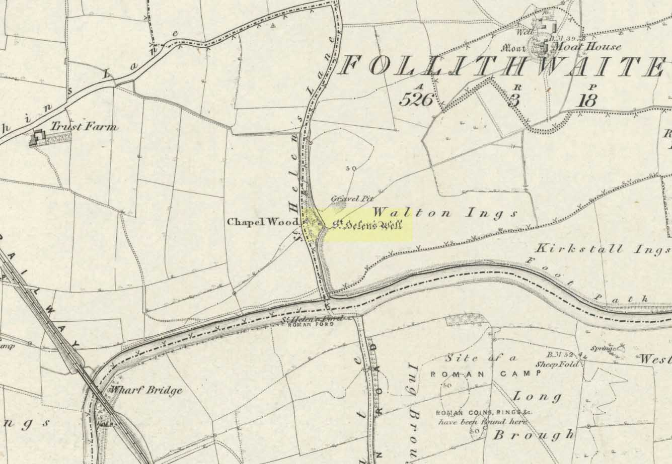
This ancient and well-known healing spring is shown on early OS-maps emerging a short distance north of the River Wharfe besides St. Helen’s Beck in Chapel Wood, adjacent to the Kirkstall Ing or field.  In the western fields close by was once an ancient chapel and, closer to the holy well, once “stood St. Helen’s (or St. Helena’s) Cross, which is somewhat crudely represented in Dr. Whitaker’s History of Craven“, (Speight 1902), illustrated here.

This well possesses a prodigious occult history yet is curiously absent from most studies on the subject.  The place is said to have been a respected holy site that was venerated long before the Romans arrived here. Found at a place called the Rudgate — but known locally as St. Helen’s Ford — it is also said to be haunted.  Angela Smith (n.d.) considers the traditions surrounding the well to be pre-Roman, and the curative waters would certainly have been known of at the time of their occupation here,

“because it lies at the side of Roman road No.280, just north of where it crosses the River Wharfe at St. Helen’s Ford, leading to the Roman fort at Newton Kyme.”

St Helens Well in 1900

Several species of psychoactive plants grow adjacent to the well, which are thought by Phillips, (1976) Devereux (1992) and I as serving ritual shamanic purposes. The likelihood is more so than not.  The oracular nature of the site which R.C. Hope (1893) and others have described here is particularly interesting: in traditions the world over, oracles were often consulted after the ingestion or use of sacred plants, such as are found here.

Due to the sacred nature of this spring and its importance in local folklore and history, it should be recovered from its present state.  The fact that this place was highly important as a ritual and sacred site to christians, pagans, Romans and peasants alike, and now hides all-but-lost and forgotten is a disgrace.

Folklore

A fascinating tale hangs over this still-revered holy well which legend tells had a chapel standing adjacent, dedicated to Helen in the 7th century – although no trace of it is visible today. Local historian Edmund Bogg (1904) recounted how a local sexton told of “padfoots and barguests and ‘that grim foul beast with clanking chain’ which on dark nights kept its vigil” near St.Helen’s Well. Padfoots and barguests are Yorkshire names for spectral black dogs, said to be bringers of death and misfortune (they are one of several remaining folk-ingredients from the Underworld myths in British shamanism).

St Helen’s Well, c.1935
St Helens Well in 1934

Folklorist Guy Ragland Phillips (1976), referring to an article in The Dalesman in 1971, told how a Mrs Dorothy Tate as a young girl used to visit the site and would tie pieces of rag on the bushes aside the place as grateful offerings to the spirit of the well. She said however, that she had gone about doing this in the wrong way, as according to tradition such offerings are to be done secretly. The article showed a photograph of Mrs Tate (from 1908) tying one of the memaws to the wych-elm tree overhanging the old spring.

People visited the well – probably on August 18 – to divine the future with the oracle which Hope (1893) described as being here, always in the dead of night without being seen, leaving before sunrise. It has been visited by thousands of people over the centuries, with gifts of rag-hangings, pins and other memaws. Such offerings continue even to this day. When Harry Speight (1902) visited St. Helen’s Well at the turn of the century, he related how as many as forty or fifty hangings would be left at any one time on the branches of the trees.  He wrote:

“The water is beautifully soft and clear, and in former times was much resorted to as a specific for sore or weak eyes. There are two other springs close by, which were also held to be sacred, but they do not bear any particular dedications. An old plantation a little north of the well is known as Chapel Wood, which commemorates St. Helen’s chapel and the ancient church at Bilton, three miles further north, and about a mile to the east of the Roman Rudgate, is also dedicated to St. Helen.”

A few years before Speight’s visit here, Dr Fred Lees and the botanist, Robert Baines, visited St. Helen’s Well, and wrote similarly of the lore and memaws they found there:

“There are veritably hundreds of these bedizenings affixed and removed surreptitiously (probably before sunrise), according to an unwritten law, for none are ever caught in the act. And yet during the summer months a careful observer may detect almost weekly evidence of a shy communicant with the ghostly genius of someone¾country maid or her dumb shy swain. What murmured litany (if any) had to be said is lost; most likely nothing more was necessary than the unspoken wish…Pieced together and codified, fact and heresay testify as follows: ‘The visitor to the grove, before rise of sun, has to face the tree [a wych-elm overhanging the well] to detach from his or her own person some garment, to dip it in the well, and having knotted or whilst hanging the fragment to any convenient twig…is to breathe a ‘wish’ telling no-one what that wish may be; these conditions strictly observed, what is desired shall come to pass.'” (in Phillips, 1976)

When the archaeologist C.N. Bromehead (1935) and geologist J.V. Stephens came to the site in the 1930s, despite the fall of the well, he was surprised to find local peasants still respecting the spirits of the site, reporting:

“There is now no well or visible spring, but from the position at the lower margin of a gravel terrace it is obvious that water would be obtained by digging a few feet; a small stream flows just east of the site… It is curious that the hanging of rags should survive when the actual well has vanished, but the writer has visited the spot many times in the last seven years and there are always plenty of obviously recent additions.  The custom is to stand facing the well (i.e., due west), preferably after sunset, wish, and then attach something torn from one’s clothing either to the big tree — wych elm — or to any of the bushes.  Probably the custom is largely maintained by vagrants who frequently camp in the wood, but it also has its attraction for courting couples from the neighbouring villages!”

Such offerings at the site of St. Helen’s Well are still left by locals and some of the plastic pagans, who tie pieces of artificial material to the remnants of the wych-elm and other trees, which actually pollutes the Earth and kills the spirit  here.  Whilst the intent may be good, please, if you’re gonna leave offerings here, make sure that the rags you leave are totally biodegradable.  The magical effectiveness of your intent is almost worthless if the material left is toxic to the environment and will certainly have a wholly negative effect on the spirit of the place here.  Please consider this to ensure the sacred nature of the site.

…to be continued…

References:

  1. Bogg, Edmund, Lower Wharfeland, the Old City of York and the Ainsty, James Miles: Leeds 1904.
  2. Brewster, Sam, ‘St. Helen’s Well,’ in Wind & Water 1:4, 1980.
  3. Bromehead, C.N., ‘Rag Wells,’ in Antiquity IX, March 1935.
  4. Devereux, Paul, Symbolic Landscapes, Gothic Image: Glastonbury 1992.
  5. Hope, R.C., Legendary Lore of the Holy Wells of England, London 1893.
  6. Ni’Bride, Feorag, The Wells and Springs of Leeds, PPP: Preston 1984.
  7. Phillips, Guy Ragland, Brigantia, RKP: London 1976.
  8. Smith, Andrea, ‘Holy Wells Around Leeds, Bradford & Pontefract,’ in WakefieldHistorical Journal 9, 1982.
  9. Speight, Harry, Lower Wharfedale, Elliott Stock: London 1902.
  10. Whelan, Edna, The Magic and Mystery of Holy Wells, Capall Bann 2001.
  11. Whelan, Edna & Taylor, Ian, Yorkshire’s Holy Wells & Sacred Springs, Northern Lights: York 1989.

© Paul Bennett, The Northern Antiquarian


Old Wife Ridge, Heyshaw Moor, Dacre, North Yorkshire

Sacred Hill:  OS Grid Reference – SE 159 626

Getting Here

Long worn stone on Old Wife Ridge

From the bottom of Pateley Bridge, just out of town take the left turn to Bewerley and go through the village; or from Glasshouses follow the road over the River Nidd and round.  Both ways take you to meet the steep and winding Nought Bank Road, which you should follow all the way to the top of the moorland hill.  You can just park up by the footpath taking you east.  Then cross the road and walk west on the dirt-track to Rowan Tree Crags.  100 yards along, the gentle sloping moor on your left is the Old Wife’s Ridge.

Archaeology & History

The academic history of this moorland is poor, save occasional notes about lead mining and quarrying (Jennings 1967).  Speight (1894) describes the finding of large pieces of lead-worked Roman inscriptions nearby that were found in January 1735 — one of which had the letters ‘BRIG’ cut into it, thought to be a referral to the land or deity, Brigantia.  Examples of prehistoric rock art occur at nearby Guisecliff Woods, due east, but there are no specific notices about the archaeology of this hillside.

Long overgrown stone at Old Wife Ridge

When we visited the place yesterday, much of the heather had been burned (the previous year) and we found two stones which looked suspiciously as if they had stood upright in the past, and may have had played some part in the naming and myth of the Old Wife on this part of the moors.  I can find no other records of any remains here.

Folklore

References to the Old Wife scatter our northern lands and invariably refer to an aspect of the heathen Earth Mother of our peasant ancestors, particularly in Her aspects of winter and early spring.  In Scotland and Ireland She was commonly known as the cailleach.  Sadly I can find no extant lore relating to Her mythic aspects in the landscape on these hills.  A field-name to the south, Nanny Black Hill, may have related to the Old Wife.

References:

  1. Jennings, Bernard (ed.), A History of Nidderdale, Advertiser Press: Huddersfield 1967.
  2. o’ Crualaoich, Gearoid, The Book of the Cailleach, Cork University Press 2003.
  3. Speight, Harry, Nidderdale, Elliot Stock: London 1894.

© Paul Bennett, The Northern Antiquarian


Devil’s Blue Stane, Crail, Fife

Legendary Rock:  OS Grid Reference – NO 614 079

Also Known as:

  1. Devil’s Blue Stone

Folklore

This curious rounded boulder sitting outside the parish church was described by Alexander Polson in his survey of witch-lore.  He told us that “when the old church was being built, the devil, as a mason out of work, came here and was employed.”  But it wasn’t long before a local christian discovered his disguise and, uttering some magickal biblical words, the devil became furious.

“Immediately he heard this there was a clap of thunder and the fiend flew away to the Isle of May,” about five miles away to the south. “Here in his anger he seized a huge rock and hurled it at the church. It fell quite near, did no harm, and a part of it lay at the church’s door, with the mark of the devil’s thumb on it.”

On the north end of the Isle of May are the Altar Stanes (NT 652 997), thought to have been where the devil stood (close to the holy well of St. Andrew [NT 652 994]) and threw this stone at Crail several miles north.  In pre-christian mythic terms, north is the direction or airt of greatest symbolic darkness.  A variation on the creation myth for this stone tells that when it was thrown from the island, one half of it split off and it fell by the coast in Balcombie, Fife.

References:

  1. Polson, Alexander, Scottish Witchcraft Lore, W. Alexander: Inverness 1932.

© Paul Bennett, The Northern Antiquarian


Nanny Howe, Kildale, North Yorkshire

Tumulus:  OS Grid Reference – NZ 599 103

Archaeology & History

Plan of Nanny Howe (after R.H. Hayes)

The Nanny Howe burial mound was one of a group of at least three tumuli that could be found on what is now the wooded hilltop of Coate Moor, a mile east of Great Ayton.  Large and conspicuous in previous centuries, the site was described briefly in Elgee’s (1933) archaeological survey as being in association with a prehistoric settlement, which itself appears to have long since succumbed to forestation.  An essay on the state of this apparent Bronze Age burial mound was written by Mr Hayes (1966), who told us:

“The kerb of the barrow was exposed and noticed by J.N Grayson whilst excavations were in progress on Great Ayton Moor.  S.V. Morris, A.N. Pacitto and the writer examined the site.  It was a cairn of about 30ft diameter and 3ft high in the centre, with a strong kerb of stones set on edge of 25ft diameter.  Its construction, of massive stones was similar to the chambered cairn on Great Ayton Moor, one mile to the north, and very like the food vessel-urn tumulus on Danby Rigg which also had a kerb of the same diameter…

“When the heather and turf were removed on the south-east side of Nanny Howe, a mass of cremated bones with part of the rim and side of a typical Iron Age ‘B’ jar were found only 6-9in under the turf.  This was clearly a secondary burial long after the cairn was built.  The sherd may have been a token offering, but more probably the remainder of the pot so near the surface of the mound had been eroded.  No other secondary burial was found, although almost all the cairn was removed.

“Under large boulders in the central area was a shallow pit or depression… Only minute specks of charcoal and some small burnt stones distinguished its filling  from natural sand.  It was about 3ft in diameter and not more than 9in deep… In it were the broken sherds, more than 80 in number, of a beaker… There were no signs of bones or cremation, although presumably a contracted skeleton had accompanied the beaker.  In the acid sand all bones would perish quickly… No other relics were found in the cairn.”

To which Mr Hayes and his team concluded the Nanny Howe tomb  was an example of a typical “beaker burial” as they used to like calling them, set within a ring of stones over which the cairn was piled; and long after this, seemingly the Iron Age, a secondary cremation was inserted.

Folklore

Folklore ascribed the entire settlement here to have heathen origins, with Nanny Howe also standing out with folklore of its own.  As Mr & Mrs Elgee (1933) wrote:

“Half a mile east of Captain Cook’s monument…on Easby Moor is the Devil’s Court, where, according to tradition, witches congregated under the presidency of their lord and master.  We therefore examined the Court and found what we expected, a typical moorland Bronze Age settlement site, with stone-walled enclosures, shallow pits, flint implements and many barrows, one of which is named Nanny Howe, after a famous witch, it is said, who also frequented Nanny Nook, a right-angled bend in a stone wall near Wayworth Farm, Commondale, marking another settlement site.”

Another tale of this legendary witch was narrated by folklorist and historian Richard Blakeborough in one of his many tomes, where he told:

“Again, old people of Great Ayton still aver that on a certain night a once noted witch, Nanny Howe, may be seen riding astride on a broomstick over Howe Wood just at midnight. This witch, so mounted, is said once to have chased the devil for miles — on this occasion the two must have fallen out ; perhaps at that time honest folk got their due. Howe Wood is near Kildale.”

Whatever the source of such stories, the respective archaeologists of Elgee and Hayes wondered if they derived from some pre-christian rites and events.  Hayes asked:

“Was the person interred in Nanny Howe a famous witch?  Or were the witch and the devil legends connected with the site faint echoes of ceremonials and rites held here?”

It would seem likely that the local peasant communities hereby were, thankfully, not inflicted with the empty spirituality of the christian cult when it tried taming the souls of the villagers living in and around here.  The folklore would seem to reflect simple peasant gatherings and celebrations, frowned upon by those weird clergy-folk, no doubt striving to get the local children into their more demonic pastimes…

References:

  1. Blakeborough, Richard, Wit, Character, Folklore and Customs of the North Riding of Yorkshire, W. Rapp: Saltburn 1911.
  2. Elgee, Frank & Harriet, The Archaeology of Yorkshire, 1933.
  3. Gutch, Mrs E., Examples of Printed Folklore Concerning the North Riding of Yorkshire, David Nutt: London 1899.
  4. Hayes, R.H., “Nanny Howe, Coate Moor, Cleveland,” in Yorkshire Archaeological Journal, part 164, 1966.

© Paul Bennett, The Northern Antiquarian


Clach na Buidseach, Strathtay, Perthshire

Cup-Marked Stone:  OS Grid Reference – NN 916 541

Also Known as:

  1. The Witchcraft Stone
  2. Witches Stone

Folklore

In Mr Kennedy’s book (1927) on the folklore of Strathtay, he informed that this Witches Stone was examined and taken to Edinburgh sometime in the 19th Century, but returned to its home by a local man called Mr McNaughton who lived at Bail-an-eas.  The stone was restored close to the walls in which it was first found.  He also told us the following:

“In bygone days the witches of Strathtay amd Grandtully had their great meeting place at Tulliepourie. There the Witches’ Stone…with its round bowl-shaped holes, is still in evidence. Satan attended and assumed the shape of a he-goat; but going to the meeting he is said to have rolled along in the shape of a large cart-wheel – gyrating and describing the figure eight. This must have been an exceedingly interesting site! The orgies that ensued at these meetings were disgustingly wicked!”

The fairy folk, whose main home was the hill of Craig Scriadlain further uphill from here, would also have their revelries here.  Many of the other sites near here were also used by the same little people of Scriadlain.

References:

  1. Kennedy, James, Folklore and Reminiscences of Strathtay and Grandtully, Munro Press: Perth 1927.

© Paul Bennett, The Northern Antiquarian


Hawk Stone, Spelsbury, Oxfordshire

Standing Stone:  OS Grid Reference – SP 33923 23544

Getting Here

Hawk Stone on 1885 map

Best visited out of season before the corn’s been planted. It makes it  easier to find and doesn’t annoy the land-owner here, who tends to be a decent dood.  From Chipping Norton go southeast along the B2046 road to Charlbury.  After about 1½ miles take the second right turning down the small country lane.  Go slowly down here for less than half a mile, watching the fields on your right.  You’re damn close!

Archaeology & History

The Hawk Stone

This impressive, weather-worn, eight-foot tall standing stone stands aloft in the middle of a field due west of the road between Chalford Green and Dean.  It’s an excellent monolith and one which, I think, has a lot more occult history known of it than described here.  Thought by O.G.S. Crawford (1925) and others in the past to have been “formerly part of a chambered structure,”  or prehistoric chambered tomb like that of the Hoar Stone at nearby Enstone, no remains of such a structure unfortunately remain today.  It is first illustrated and named on a local map of the region in 1743 CE, and the stone at least has fortunately managed to escape the intense agricultural ravages endemic to this part of the country.

The name “Hawk” stone has been fancied by some to relate to some obscure resemblence to a Hawk, or because there very often are hawks hovering over those upland fields – but these are unlikely.  It’s thought by place-name authorities more likely to derive from a corruption of ‘Hoar’ meaning a grey or boundary stone; and as it stands just yards east of the present township boundary line, this derivation seems more probable.

To all lovers of megalithic sites, we highly recommend a visit here!

Folklore

In local folklore and in the opinion of some earlier historians, the Hawk Stone formed an integral part of a stone circle here, but there is little known evidence to substantiate this.

Hawk Stone in summer
Hawk Stone in winter

A creation legend attached to this site tells that the stone was thrown, or dragged across the land, by a old witch or hag — though we are not told from where.  This is a motif found at megalithic sites all across the country (see Bord & Bord 1977; Grinsell 1976, etc).  In Corbett’s History of Spelsbury (1962) the author told of the folklore spoken of by one Mr Caleb Lainchbury who

“said the cleft at the top of the Hawk Stone at Dean was supposed to of been made by the chains of the witches who were tied to it and burnt. As witches seem to have been extremely rare in Oxfordshire it cannot have been a very common practise to burn them at Dean; but there may indeed have been some kind of fire ceremonies near the stone.”

Grinsell (1976) also tells how the Hawk Stone has that animistic property, bestowed upon other old monoliths, of coming to life and going “down to the water to drink when it hears the clock strike 12.”

This evidently important and visually impressive monolith also plays an important part in an incredibly precise alignment (ley) running roughly east-west across the landscape.  At first, Tom Wilson (1999) thought the alignment had previously gone unnoticed, but later we later found a reference to the same line in an early copy of The Ley Hunter (Cooper 1979). It links up with other important megalithic sites, such as the Hoar Stones at Enstone, Buswell’s thicket, and the ancient Sarsden Cross.

Similarly, when Tom Graves’ (1980) was doing some dowsing experiments at the Rollright stone circle a few miles west, he found what he described as an ‘overground’ (or ley) linking the ring of stones to the Hawk Stone, but no other connecting sites are known along this line.

References:

  1. Bennett, Paul & Wilson, Tom, The Old Stones of Rollright and District, Cockley: London 1999.
  2. Bord, Janet & Colin, The Secret Country, BCA: London 1977.
  3. Cooper, Roy, “Some Oxfordshire Leys,” in The Ley Hunter, 86, 1979.
  4. Corbett, Elsie, A History of Spelsbury, Cheney & Sons: Banbury 1962.
  5. Crawford, O.G.S., The Long Barrows of the Cotswolds, John Bellows: Gloucester 1925.
  6. Gelling, Margaret, The Place-Names of Oxfordshire – volume 2, Cambridge University Press 1954.
  7. Graves, Tom, Needles of Stone, Granada: London 1980.
  8. Grinsell, L.V., Folklore of Prehistoric Sites in Britain, David & Charles: Newton Abbot 1976.

© Paul Bennett, The Northern Antiquarian 


Jinny Well, Newchurch-in-Pendle, Lancashire

Sacred Well:  OS Grid Reference – SD 82377 39458

Getting Here

Easy to locate: it’s just by the roadside on the left-hand side of the road, Jinny Lane, coming out of the village, just after the last house where the field begins.

Archaeology & History

Nowt to write home about, as they say.  The waters here trickle from the earth into an old stone trough — but they don’t look too appetizing (even I didn’t have a drink, which is something of a rarity!).  Its the folktale accompanying this little site, giving a distinct hint of some heathen past, that I found intriguing.

Folklore

Here was once the spirit of a woman called Jinny – who gave her name to the road it’s on – that wandered betwixt the well and an old stone, once found further up the hillside (after a bitta digging, we found the remains of the old stone, previously an authentic monolith). It was said that if you wandered along the road on certain moonlit nights, her spirit would chase you. To make matters worse, the ghost was a headless one!

Jinny’s spirit originally resided, peacefully, in the broken old stone atop of the hill. At a certain time of the year, the spirit of the stone would venture downhill to drink from the waters here (much as we find at Rollright and other places). But one day a xtian priest came along and, because of its heathen association, broke the old stone in half and cursed the spirit which roamed between the sites. Thereafter, Jinny’s ghost wandered in torment, with her head hacked off, scaring people half to death when they saw her. And so, another priest was eventually called who, to the satisfaction of local people, eventually put Jinny’s ghost to rest, as they say. It seems to have been a successful ritual, as no-one has reporting seeing the headless ghost for many a long year.

References:

  1. Byrne, Clifford H., Newchurch-in-Pendle: Folklore, Fact and Fiction, Marsden Antiquarians: Nelson 1982.

© Paul Bennett, The Northern Antiquarian


Frensham Common necropolis, Frensham, Surrey

Tumuli:  OS Grid Reference – SU 853 406

Archaeology & History

There are several tumuli near the top of the hill here, but only one of them really stands out.  Nick Thomas (1976) told it to be one “of the best preserved bowl barrows in Surrey.”  A brief description of the relevant tombs, running north to south:

“the first is 75ft across and 6ft high; the second, which has a surrounding ditch 9ft wide, is also 75ft across, but is 8ft high.  The third has a diameter of 42ft and a height of 4ft.  The last is 54ft wide and 5½ft high.  It has a surrounding ditch 8ft wide. ” (Thomas 1976)

None of the tombs had been excavated up to the early 1980s, but I’m not sure if anything has been found since then.  There was also a potential “great stone” up here that was mentioned by John Aubrey in the late 17th century, but nothing has been seen of it since.  In all probability this was a standing stone or the remains of some prehistoric tomb.

Folklore

Several hundred years ago the King’s antiquary, John Aubrey, told the curious tale of the great cauldron that was said to have been found here:

“In the vestry (of Frensham church, in Surrey), on the north side of the chancel, is an extraordinary great kettle or caldron, which the inhabitants say, by tradition, was brought hither by the fairies, time out of mind, from Borough-Hill, about a mile hence. To this place, if anyone went to borrow a yoke of oxen, money, etc., he might have it for a year or longer, so he kept his word to return it. There is a cave where some have fancied to hear music.  On this Borough hill…is a great stone lying along, of the length of about six feet. They went to this stone and knocked at it, and declared what they could borrow, and when they would repay, and a voice would answer when they should come, and that they should find what they desired to borrow at that stone. This caldron, with the trivet, was borrowed here after the manner aforesaid, and not return’d according to promise; and though the caldron was afterwards carried to the stone, it could not be received, and ever since that time no borrowing there.”

In relation to the folklore that is generally attached to the tumulus on top of the hill here from which modern lore ascribes the cauldron to have originated, when A.G. Wade (1928) came to investigate the nature of the site and the folktale he found that,

“there are several folk-tales other than those given by Aubrey.  One relates that it was dug up on Kettlebury Hill, south of Hankley Common, by the monks of Waverley Abbey, and that it was taken by them to Frensham for brewing ale.  Another tale says that it was a loan from the fairies of Thursley — there are tumuli in this parish, south of Ockley Common — and that Mother Ludlam, a medieval witch who lived, according to tradition, in Ludlam’s Cave in Moor Park, was the owner and lender.  The cave was dug by a monk of Waverley Abbey who, when the water supply of the Abbey failed, found that three springs joined here, and by enlarging their outlets and bringing them together he obtained a good supply of fresh drinking water…”

Mr Wade was also unable to satisfactorily show that the Borough Hill named in Aubrey’s survey and Frensham Common hilltop were one and the same.

References:

  1. Aubrey, John, The Natural History and Antiquities of Surrey, E. Curll: London 1719.
  2. Thomas, Nicholas, Guide to Prehistoric England, Batsford: London 1976.
  3. Wade, A.G., “The Great Cauldron of Frensham,” in Antiquity, 2:6, June 1928.

© Paul Bennett, The Northern Antiquarian


Smoo Cave, Durness, Sutherland

Cave:  OS Grid Reference – NC 419 672

Getting Here

From Durness take the road east for a couple of miles till you see the signpost which takes you on the left-hand side of the road, down to the coast.  You can’t miss it!

Archaeology & History

Findings here allege to take the history of the place into the mesolithic period, but we don’t know this for sure.  An excavation here by a Mr Donald Macdonald of Sangobeg in 1904 uncovered the presence of several small bone pins, which seem consistent with Mesolithic finds elsewhere.  When archaeo-excavations were done here in 1982, human remains going back to at least Iron Age were found in the simple deposit of many shells.  A further analysis by the Glasgow Archaeology Unit in 1996 was prevented of some excavation by (get this!) those screwy Health & Safety regulations.  Here’s a definite case for an independent group to undertake work here, as we could ignore such preventative measures (and if we drown it’s our fault!).  Smoo Cave’s primary function is pretty obvious: it would have been used for both shelter and ritual. 

Folklore

The folklore here tells of magick and occultism and possible remnants of rites of passage lore. For herein, many centuries ago, a powerful land-owner called Lord Reay — reputed as a master in the black arts — battled with the devil in the Smoo Cave.

The devil was keeping watch on Lord Reay following a previous dispute between the two of them, and espied him as he entered the cave. As Alexander Polson told it, the cave

“consists of three caverns, one within the other. Lord Reay had got as far as the second, and his dog, which had gone on in advance, returned howling and hairless. By this, Lord Reay knew that Satan was there before him, and bravely waited the attack, which was soon made, and his lordship fought lustily. Happily at the opportune moment a cock crew. This frightened the devil and his attendant witches, but Lord Reay stood between them and the exit. In their fright they blew holes through the roof of the cave, and this is the origin of the two openings through which the Smoo burns fall.”

Pitch black cave; protective spirit animal; encountering one’s psychological nemesis; unconscious battles with Underworld forces; rebirth of the sun at cock-crowing time; the conquering of the dark forces and renewal of Lord Reay.  These are typical hallmarks probably signifying folk-remnants of shamanism and rites of passage, for which this cave may once have been used.

References:

  1. Polson, Alexander, Scottish Witchcraft Lore, W. Alexander: Inverness 1932.

© Paul Bennett, The Northern Antiquarian 

Doubler Stones, Ilkley Moor, West Yorkshire

Cup-and-Ring Stones:  OS Grid Reference – SE 0723 4652

Also Known as:

  1. Carving Nos. 41 & 42 (Boughey & Vickerman)
  2. Carving Nos. 6 & 7 (Hedges survey)
  3. Doublestones
  4. The Fire Stones

Getting Here

The great Doubler Stones (photo, James Elkington)

Various ways to get here, but the 2 most common are: (1) from Brunthwaite village, above Silsden, following the road uphill for a mile, then turning right (west) onto the moorland dirt-track to Doubler Stones Farm.  Just before here there’s a footpath uphill (north) for 200 yards to the stones.  (2) follow the Millenium Way footpath south up Addingham Moorside, onto Addingham High Moor.  Keep going on the same path another 500 yards and they’ll appear ahead of you.

Archaeology & History

First described as the ‘Doublestones’ in the local Addingham parish records of 1786, these great mushroom-shaped rocks were later brought to the attention of archaeologists by J. Romilly Allen in 1879 and they greatly intrigued numerous Victorian antiquarians, who puzzled as much about their exotic forms as the cup-marks on their tops!  Allen wrote of them:

Cowling’s old drawing
Hedges (1986) sketch of the design

“These rocks are by far the most remarkable freaks of Nature to be seen in the district. They occupy a prominent position, perched on the extremity of a rocky knoll which juts out into the valley; and as seen from below, with their weird forms standing out clear and sharp against the background of blue sky, they present so extraordinary an appearance that they would at once attract the attention of even the most unobservant.  In general outline they resemble gigantic toadstools; and I presume that they are called Doubler Stones from the fact of their shapes being almost identical.  They may be appropriately described as Nature’s Twins.  The upper surface of the cap of one of these stones has three large basin-shaped cavities in it.  Two of these lie along the central axis of the stone, and measure respectively 1ft 3in by 2ft 9in deep, and 1ft 9in by 1ft 3in by 9in deep.  They are united by a deep groove, a continuation of which runs out over the edge of the stone at each end.  There is another basin lying to the west side of the two central ones, with one of which it is connected by grooves.  It measures 2ft by 1ft 9in and is 9in deep.  There is no direct evidence that these basins are artificial; but it is quite possible that they may have been so originally, and have been enlarged by natural agencies.  But in addition to the basins, are twenty-six cup-markings of distinctly artificial origin.  They vary in diameter from 2 to 4 in.  One group of cups appears to be arranged in parallel rows.”

Doubler Stones, c.1890

Although the writer thought there were no artificial cup-markings on the other Doubler Stone (the one on the left in the photo), John Hedges (1986) and Boughey & Vickerman (2003) cite there to be at least two cup-markings on this rock.  Other writers have given different numbers for the respective cup-marks thought to be on these rocks down the years.

If you’re into prehistoric rock-art, check this place out.  If you’re a geologist and aint been here, you’ll be even more impressed!

Folklore

Approaching the Doublers (photo – James Elkington)

In Nicholas Size’s Haunted Moor (1934) he described the Doubler Stones as being the abode of ghosts and a place of sacrificial rites in ancient days. While in Guy Ragland Phillips’ Brigantia, we find that the word ‘doubler’ itself “is a large shallow dish, bowl or plate” – which we find on top of the greater one of these two well-worn-weirdoes.  As well as being haunted, there is some other little-known, though not unexpected folklore here, which told these old stones to be the meeting place of witches in previous centuries.

In addition to this, we are told that the witches of Fewston valley to the west used to meet up with the more famous Pendle witches at these stones.  One historian proclaimed that this notion was spurious, as it would be too far for the Pendle witches to walk – which says more about the historian in question than the people of previous centuries.  The distance from Pendle to the Doublers can be traversed in a day and is an ideal meeting spot, away from the prying eyes of a wrathful Church, that sought war against the animistic practices of our ancestors.

References:

  1. Allen, J. Romilly, ‘The Prehistoric Rock Sculptures of Ilkley,’ in Journal of the British Archaeological Association, volume 35, 1879.
  2. Allen, J. Romilly, ‘Notice of Sculptured Rocks near Ilkley,’ ibid, volume 38, 1882.
  3. Bennett, Paul, The Old Stones of Elmet, Capall Bann: Chieveley 2001.
  4. Boughey & Vickerman, Prehistoric Rock Art of the West Riding, West Yorkshire Archaeology Service 2003.
  5. Cowling, Eric T., Rombald’s Way, William Walker: Otley 1946.
  6. Hedges, John, The Carved Rocks on Rombalds Moor, WYMCC: Wakefield 1986.
  7. Jennings, Hargrave, Archaic Rock Inscriptions, A. Reader: London 1891.
  8. Phillips, Guy Ragland, Brigantia: A Mysteriography, RKP: London 1976.
  9. Size, Nicholas, The Haunted Moor, William Walker: Otley 1934.

Acknowledgements:  Massive thanks to landscape photographer, James Elkington, for use of his images in this site profile.  Thanks mate! 

© Paul Bennett, The Northern Antiquarian