Caesar’s Well, Wimbledon, London, Surrey

Sacred Well:  OS Grid Reference – TQ 2237 7151

Also Known as:

  1. Robin Hood’s Well
  2. Roman Well
  3. Springpond Well

Getting Here

Caesar’s Well in the late-60s

There are numerous ways to get here from all directions: i) from the west-side of Wimbledon Common, on the Robin Hood’s Way A3 road, keep your eyes peeled for the small crossroad  of Robin Hood Lane and Road, obivously taking the one into the park. Keep on the dead straight Robin Hood Ride path until your hit the carpark ¾-mile on; and from here, bear sharp left (NW) for 250 yards or so, where a small slope down on your left takes you there; or, ii) from Wimbledon village side on the A219 Parkside A219 road, where the War Memorial stands, head onto the Common along The Causeway, past the Fox & Grapes going on Camp Road, then up the Sunset Road towards the carpark.  And then, once again go NW for 250 yards or so, where the small slope on your left takes you there.  You’ll find it.

Archaeology & History

Described by William Bartlett (1865) as “the never-failing spring of water, improperly called the Roman Well”, its constant flow was severely tested in the great drought of 1976—and it kept on flowing.  Only just though!  It was highlighted on the early Ordnance Survey map with the plain name of the Springpond Well.  The great historian and folklorist Walter Johnson (1912) gave us the best historical resumé of the site, telling that,

Caesar’s Well around 1900
Caesar’s Well around 1911

“Caesar’s Well, formerly known as Robin Hood or Roman Well—the Springpond Well on the Ordnance Map—issues on the other side of the little watershed above mentioned, at a height of 149 feet O.D.  The well lies in a little hollow, now ringed with Scottish pines. The gathering ground is the land to the east, rising to 198 feet O.D. This area is not large, but quite sufficient to maintain a permanent rill of pure water.  The well, the waters of which once were deemed of special medicinal merit, was enclosed with brick in 1829, and, as the inscription tells us, refaced with granite blocks by Sir Henry W. Peek, M.P., in 1872.  The outflowing waters descend to Brickfield Cottage, where they expand into a turbid duckpond; thence the course is through the yard behind the house, and along the north side of Robin Hood Road to Brook Cottage.  During 1911 the “Well” proper altogether dried up, but water still issued from the stand spout a few yards below, which is supplied by an artificial boring and pipe that tap the spring at a depth of 18 feet.”

Site shown on the 1874 map

The proximity of this never-failing spring to the huge prehistoric enclosure of Caesar’s Camp just a few hundred yards to the south would indicate it was an important water source in Bronze Age times and, I’d hazard, would have been bestowed with some sanctity, as many such wells tended to be.

Folklore

James Rattue (2008) informed us that the name Robin Hood’s Well was known here in the 18th century prior to it being known as Caesar’s Well, but there seems to be no known relationship between Robin Hood and this site.  However, a piece written in 1922 told that there was a lingering tradition that Julius Caesar encamped on Wimbledon Common in 51 BCE and that this folk memory was kept alive in the lore of local children who devoutly believed that the great Roman Emperor drank from the cool depths of this well.

References:

  1. Bartlett, William A., The History and Antiquities of the Parish of Wimbledon, Simpkin Marsall: London 1865.
  2. Hughes, John L., “Caesar’s Well, Wimbledon Common,” in Source magazine, no.9, Spring 1989.
  3. Johnson, Walter, Wimbledon Common – Its Geology, Antiquities and Natural History, T.Fisher Unwin: London 1912.
  4. Rattue, James, Holy Wells of Surrey, Umbra: Weybridge 2008.

© Paul BennettThe Northern Antiquarian

Oliver’s Mound, Richmond Park, Surrey

Tumulus (destroyed):  OS Grid Reference – TQ 192 735

Also Known as:

  1. Oliver’s Mount

Archaeology & History

Roque’s 1746 map

Oliver’s Mound was highlighted as early as 1746 on John Roque’s map of the Country Near Ten Miles Round (London) as still standing.  One hundred and fifty years later, when the Ordnance Survey lads came to map the area, it had gone.  We don’t know exactly when it was demolished, so Historic England (not necessarily a good measure of accuracy) tell us its demise occurred “between 1760 and 1868”, so giving themselves at least some degree of safety!

As we can see in Mr Roque’s old map, an avenue of trees led up to the barrow.  This avenue will have been created when Richmond Park and its gardens were laid out.

The round barrow was most likely Bronze Age in origin.  The historian and folklorist Walter John (1093) reported that in 1834, three skeletons were found at a  depth of a yard beneath the surface.

Folklore

Site shown on 1873 map

Traditional tells that the name of this barrow comes from when the religious extremist, Oliver Cromwell, and his men, set up camp here.  A slight variant tells that Cromwell stood here to watch a skirmish.

References:

  1. Cundall, H.M., Bygone Richmond, Bodley Head: London, 1925
  2. Grinsell, Leslie V., The Ancient Burial Mounds of England, Metheun: London 1936.
  3. Johnson, Walter, Neolithic Man in North-East Surrey, Elliot Stock: London 1903.
  4. Johnson, Walter, Folk Memory, Clarendon: Oxford 1908.

© Paul BennettThe Northern Antiquarian

Caesar’s Camp Barrow, Wimbledon, Surrey

Tumulus (destroyed):  OS Grid Reference – TQ 222 709

Archaeology & History

It seems that a great number of prehistoric remains used to exist in and around the Wimbledon Common area.  This one is mentioned only briefly in Thomas Stackhouse’s (1833) rare work on early British remains, where he wrote:

“Near an old single-trenched Camp at the South West comer of Wimbledon Common, is a very small flat Barrow cut into the form of a cross: I don’t know that it has been noticed by any writer.”

The “single-trenched Camp” he described is today known as Caesar’s Camp hillfort.  By the time the Wimbledon historian William Bartlett (1865) came to write his survey, the site had been destroyed.  In Mr Johnson’s (1903) survey, he seems to confuse this site with the large barrow cemetery that used to exist on the northern edges of Wimbledon Common described by William Stukeley and others.

(the grid-reference to this site is an approximation).

References:

  1. Bartlett, William A., The History and Antiquities of Wimbledon, Surrey, J. & S. Richards: Wimbledon 1865.
  2. Johnson, Walter, Neolithic Man in North-East Surrey, Elliot Stock: London 1903.
  3. Stackhouse, Thomas, Two Lectures on the Remains of Ancient Pagan Britain, privately printed: London 1833.

© Paul BennettThe Northern Antiquarian

Cedars Road, Clapham, Surrey

Tumulus (possible):  OS Grid Reference – TQ 2856 7555

Also Known as:

  1. Mount Nod

Archaeology & History

Located on the old boundary line between Clapham and Battersea, what might have been a forgotten tumulus, whose memory was thankfully preserved by the renowned folklorist and historian Walter Johnson (1903), was described in his work on prehistoric Surrey.  He seemed to think it serious enough to add to his survey, where he told us that,

“there still exists, near Cedars Road, Clapham, what may possibly be a round barrow.  It is in the garden of a house opposite St. Saviour’s Church, and is visible to anyone passing along the old, narrow passage called Wix’s Lane.  Mr. J.W. Grover, who brought the matter before the Archaeological Association in 1884, had been struck by the discovery that old maps marked the spot ‘Mount Nod Fields.’  …The mound must originally have been 70 or 80 feet across, but had been tampered with on one side for the construction of an ice-house.  Mr. Grover suggested that the mound may be of Celtic date.  To us, the height—some 12 feet or more—together with marked signs of reconstruction at a comparatively modern date, indicate the necessity of withholding judgment. The original tumulus may simply have been increased in height, but…digging alone could settle the question.”

Local historian Michael Green (2010) has found that there were prehistoric tombs on Clapham Common only 500 yards away, so this one along Cedar Road was not in isolation.  Is the site named on the boundary perambulation records?  Has it been explored since Johnson wrote about it and, if so, has its veracity as a prehistoric tomb been ascertained, or is it merely the remains of some post-medieval creation?

References:

  1. Green, Michael, “Mount Pond, Clapham Common: Archaeology and History“, Clapham Society Local History Series, 2010.
  2. Grover, J.W., “Mount Nod, Clapham,” in Journal of the Archaeological Association, volume 40, 1884.
  3. Johnson, Walter, Neolithic Man in North-East Surrey, Elliot Stock: London 1903.

© Paul BennettThe Northern Antiquarian

Lambeth Wells, Lambeth, London, Surrey

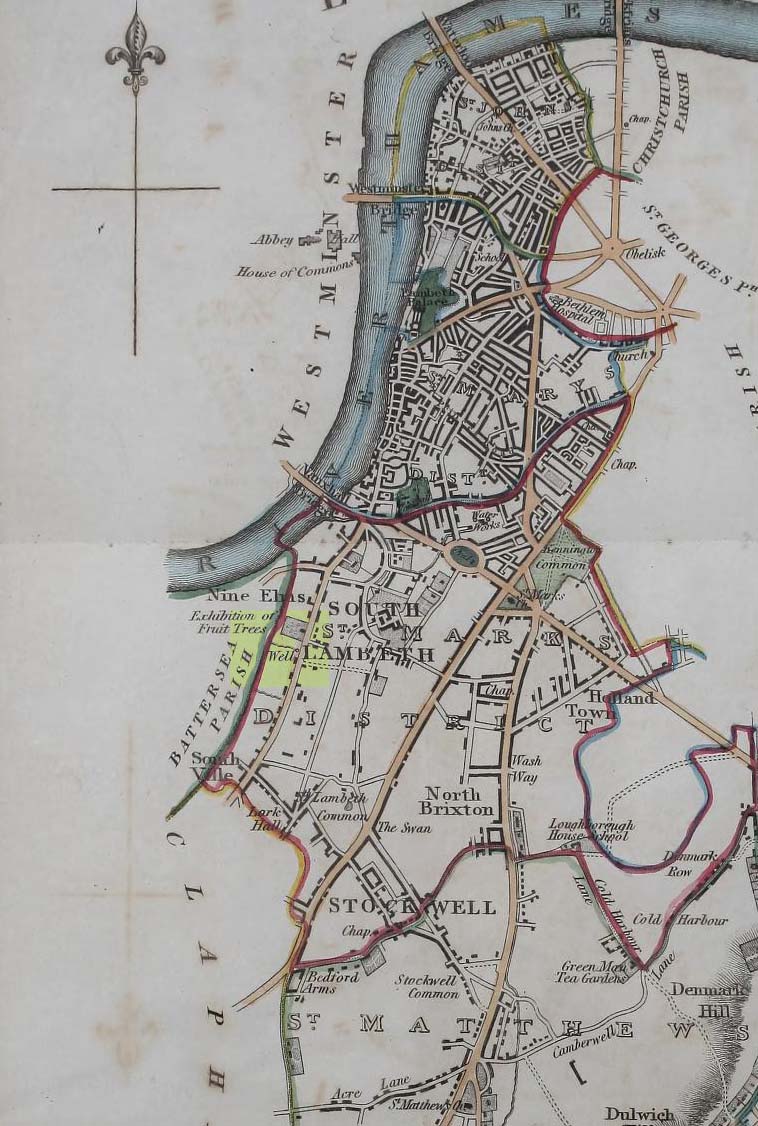
Healing Wells (destroyed):  OS Grid Reference – TQ 3094 7889

Also Known as:

  1. Lambeth Spa
  2. Near Well and Far Well

Archaeology & History

This once famous healing or spa well has long gone.  It was located where the buildings that now constitute 104-105 Lambeth Walk presently stand: an area which the great London historian William Thornbury (1878) told was already “a favourite resort of Londoners, and celebrated for the variety of sweet-smelling flowers and medicinal herbs growing there,” complementing the healing waters before and during the spa craze.  The great herbalist John Gerard did his collections here.

I can find no information regarding its early use by our peasant ancestors, so its written history simply begins when it had been appropriated by those well-to-do up-market types who took this medicinal spring for their commercial gain in the early days of the trendy spas.  Supplied by two separate springs known as the Nearer and Farther Wells respectively, the Well House built here was “formally opened in April 1696” and subsequently had almost daily accompaniments of music, including French and country dancing!  But as the popularity of the Lambeth Spa increased, so did its problems.  Phyllis Hembry (1990) told that by July 1715, one visitor to the spa,

“was so depressed to find that the many people there were mostly rakes, whores and drunkards, idlers such as Guard officers, or young pleasure-seeker like attorneys’ clerks, mingling with loose women of the the meanest sort.  The Lambeth Wells also became a public nuisance, so a dancing license was refused in 1755.”

The so-called Great Room which had been the place of great occasions by spa users ended up being the meeting place “for Methodist meetings.” Oh how the winter nights must have flown by…..

There was a decided improvement in the years that followed and social events at the spa increased again.  It became what Thornbury said “was another place of amusement.”  The Lambeth Wells, he wrote,

“were held for a time in high repute, on account of their mineral waters, which were advertised as to be sold, according to John Timbs, at “a penny a quart, the same price paid by St. Thomas’s Hospital.” About 1750, we learn from the same authority, there was a musical society held here, and lectures, with experiments in natural philosophy, were delivered by Dr. Erasmus King and others. Malcolm tells us that the Wells opened for the season regularly on Easter Monday, being closed during the winter. They had “public days” on Mondays, Thursdays, and Saturdays, with “music from seven in the morning till sunset; on other days till two!” The price of admission was threepence. The water was sold at a penny a quart to the “quality” and to those who could pay for it; being given gratis to the poor.  We incidentally learn that there were grand gala and dancing days here in 1747 and 1752, when “a penny wedding, in the Scotch manner, was celebrated for the benefit of a young couple.”

By this time, a rival St. George’s Spa of had been created a short distance away on the parish boundary and with it, the popularity and attendance at Lambeth Wells began to decline.  By the end of the 18th century, the rot had truly set in and its days were finally numbered.

As for the medicinal properties of these wells, little seems to have been recorded.  Aside from repeating the common description of them being mineral waters, William Addison (1951) simply added that they were also purgative.

References:

  1. Addison, William, English Spas, Batsford: London 1951.
  2. Allen, Thomas, The History and Antiquities of the Parish of Lambeth, J. Allen: London 1827.
  3. Allen, Thomas, A History of the County of Surrey – volume 1, Isaac Taylor: London 1831.
  4. Foord, Alfred Stanley, Springs, Streams and Spas of London: History and Association, T. Fisher Unwin: London 1910.
  5. Hembry, Phyllis, The English Spa 1560-1815, Athlone Press: London 1990.
  6. Nichols, John, The History and Antiquities of the Parish of Lambeth, J. Nichols: London 1786.
  7. Rattue, James, The Holy Wells of Surrey, Umbra: Weybridge 2008.
  8. Sunderland, Septimus, Old London Spas, Baths and Wells, John Bale: London 1915.
  9. Thornbury, William, History of Old and New London – volume 6, Cassell: London 1878.

Links:

  1. Lambeth Wells on the Vauxhall History website

© Paul BennettThe Northern Antiquarian

Southdown Cottage, Cotmandene, Dorking, Surrey

Tumulus (destroyed):  OS Grid Reference – TQ 1686 4958

The Cotmandene urn

Archaeology & History

Highlighted on the 1914 OS-map (as ‘Site of’), nothing now remains of the prehistoric structure that either covered or surrounded the ancient burial urn, found fortuitously by a Mr Turner in the garden of Southdown Cottage at the beginning of the 20th century.  Believed to be either Iron Age or Romano-British in origin, the find was noted by Mr Malden (1913) in his brief in the Surrey ArchaeologicalCollections, who wrote:   

“Early in 1913 it came to my knowledge that some years ago some discoveries had been made in the garden of a house on Cotmandene, Dorking.  Mr Turner…was digging for sand in his garden when he found a small cinerary urn (see illustration), with ashes in it.  The height is only 5 inches, the diameter across the top about 4 inches, but at the widest part 5⅜.  The urn is so small that it probably contained the ashes of a child: it is wheel-made, but badly; the diameter is not precisely the same across the top from every direction: Mr Reginald Smith attributes it to the first century BC.  Some fragments of other urns were found.  Mr Turner has kindly presented the whole specimen to the Society’s Museum.  At a lower depth in the same garden were numerous flints, some implements, many flakes, and traces of a hearth with several burnt stones. These clearly belonged to an earlier date, considerably, than the interments, but as the finds were made about 1906-7, and not investigated till this year, it is impossible to be precise about the depth at which they occurred.”

References:

  1. Malden, H.E., “A Cinerary Urn and other Matters found at Dorking and Betchforth,” in Surrey Archaeological Collections, volume 26, 1913.

© Paul BennettThe Northern Antiquarian


Bedford Hill, Tooting, Surrey

Tumulus (destroyed):  OS Grid Reference – TQ 288 726

Archaeology & History

This long lost prehistoric tomb is one of many that has fallen under the destructive hammer of the christian Industrialists in this part of the country.  Located somewhere in the parkland grounds of Bedfordhill House (also destroyed), its memory was thankfully preserved by the renowned folklorist and historian Walter Johnson (1903) who wrote of it in his work on prehistoric Surrey, where he told:

“A few years ago a supposed barrow was levelled in Bedford Park, Bedford Hill, Tooting, and no record taken of the results. The mound was enclosed in the Park for several  centuries, but when the grounds were laid out for building purposes ten or a dozen years since, it suffered rough usage, and was finally destroyed. It was nearly 100 yards long, and about 20 feet in breadth in its highest part.  It ran East and West, and had several trees growing on it before its desecration….  A moat had been made round the mound for about two-thirds of its circuit.  This moat was supplied with water by the Ritherdon, a small stream rising in Streatham.  The name is preserved in the adjacent Ritherdon Road.  The material of the mound was gravel and gravelly loam, which, in the neighbourhood, occurred only in a thin layer, thus forbidding the conclusion that the structure was merely composed of the soil dug out in making the moat. The excavated material would largely be London Clay.  As the genuineness of this barrow was, we believe, called in question after its demolition, when the subject was beyond reconsideration, we mention two shreds of collateral evidence. The ground on which the tumulus stood was about the highest in the district. The name Tooting may also have some bearing, for Mr. Clinch thinks that it was a Celtic settlement where was worshipped the deity known as Taith. (Compare also toot-hill, as exemplified in Tot Hill, Headley, Tothill Fields, Westminster, famous for fairs and tournaments, also Tutt Hill, near Thetford.)”

The ‘toot’ in Toothill however, is ascribed by Gover, Mawer & Stenton (1934) as being the usual “look-out hill”.  Although they do make note of the fact “that there is no hill in Tooting which would make a good look-out place.”  But if this was a large barrow of some type, it would explain the etymological oddity.  Any further information on this site would be welcome.

References:

  1. Gover, J.E.B., Mawer, A. & Stenton, F.M., The Place-Names of Surrey, Cambridge Univserity Press 1934.
  2. Johnson, Walter, Neolithic Man in North-East Surrey, Elliot Stock: London 1903.
  3. Smith, A.H., English Place-Name Elements – volume 2, Cambridge University Press 1954.

© Paul BennettThe Northern Antiquarian


Tumble Beacon, Banstead, Surrey

Tumulus:  OS Grid Reference – TQ 2432 5902

Archaeology & History

Tumble Beacon in 1911

This ancient “bowl barrow” as the modern archaeo’s are wont to describe it, is a Bronze Age tumulus that has seen better days.  But at least it’s still there – albeit slightly damaged and enclosed by modern housing, in the back of someone’s garden.  I expect that if you were to ask the owners, it would be OK to see this 4000 year old burial mound (in Scotland at least, we always find people very amiable when it comes to asking such things).  It’s quite a big thing too, so you can’t really miss it!  Standing more than 12 feet high, it rises like an archetypal fairy mound—now out of place—measuring some 38 yards east-west and roughly 44 yards north-south.

Highlighted on the early OS-map of the region, the name of the site indicates its multi-period usage, with the ‘beacon’ element derived  from when, in 1594, a fire was lit upon it to tell of the arrival of the Spanish Armada.  Whether it had been used as a beacon prior to that, I can find no historical accounts.  One of the early archaeological descriptions came from the pen of the old historian and folklorist, Walter Johnson (1903), who told us simply:

Tumble Beacon on 1871 map
Walter Johnson’s 1903 sketch

“About a mile South-west of Banstead Church, in a field close by Tumble Farm, on the outskirts of Nork Park, is an eminence marked on the map as Tumble Beacon.  A picturesque clump of pines stands on the mound, which, from its general character, and from the flint scraps we have found there, we have every reason to believe is a round barrow, despite the local tradition that it is a ‘sea-mark.’  The Scotch pines, in such positions as we find here, may probably, Mr. Grant Allen thought, be the descendants of trees put in by human hands when the barrow was first raised.”

Whilst this latter idea might be very hard to prove, the assertion that it’s prehistoric certainly gained favour as more antiquarians examined the site.  Johnson later told that when examining this and other sites nearby (sadly destroyed) he came across a variety of prehistoric stone utensils in the area.

References:

  1. Gover, J.E.B., Mawer, A. & Stenton, F.M., The Place-Names of Surrey, Cambridge Univserity Press 1934.
  2. Grinsell, Leslie V., The Ancient Burial Mounds of England, Methuen: London 1936.
  3. Johnson, Walter, Neolithic Man in North-East Surrey, Elliot Stock: London 1903.
  4. Lambert, H.C.M., History of Banstead in Surrey, Oxford University Press 1912.

© Paul BennettThe Northern Antiquarian


Vauxhall Well, Lambeth, London, Surrey

Healing Well (destroyed):  OS Grid Reference — TQ 3006 7734

Archaeology & History

Position of Vauxhall Well on 1824 map

In Thomas Allen’s (1827) huge survey of Lambeth parish, he told that there was little of any interest along Wandsworth Road, apart from a good orchard, “and a fine spring called Vauxhall Well.”  According to Daniel Lysons (1792), it was located “not far from the turnpike”; and according to Mr Sunderland’s (1915), was to be found “on the right-hand side of the Wandsworth Road” as you walked down it to the south.  Thankfully its position was highlighted on the 1824 map of the parish (right) that accompanied Mr Allen’s work.

It appears to have been built over in the latter-half of the 19th century, soon after William Thornbury (1878) wrote that he thought the well was still visible, but vanished soon after.

The waters were universally ascribed by all historians, from Mr Allen onwards, as being,

“esteemed highly serviceable in many disorders of the eyes, and in the hardest winter it is never known to freeze.”

The name ‘Vauxhall’ derives from that brilliantly famous family name of ‘Fawkes’ (as in Guy Fawkes), being the ‘hall of Fawkes’.  The name was first recorded here as early as 1241. (Gover et al, 1934)

References:

  1. Allen, Thomas, The History and Antiquities of the Parish of Lambeth, J. Allen: London 1827.
  2. Foord, Alfred Stanley, Springs, Streams and Spas of London: History and Association, T. Fisher Unwin: London 1910.
  3. Gover, J.E.B., Mawer, A. & Stenton, F.M., The Place-Names of Surrey, Cambridge University Press 1934.
  4. Lysons, Daniel, The Environs of London – volume 1,  T. Cadell & W. Davies: London 1792.
  5. Sunderland, Septimus, Old London Spas, Baths and Wells, John Bale: London 1915.
  6. Thornbury, William, History of Old and New London – volume 6, Cassell, Petter & Galpin: London 1878.

© Paul BennettThe Northern Antiquarian 


Stanwell Cursus, Heathrow, Surrey

Cursus (destroyed):  OS Grid Reference – TQ 0545 7431 to TQ 0448 7782

Also Known as:

  1. Heathrow Cursus

Archaeology & History

Running roughly north-to-south, this cursus was 2¼ miles long (3600 metres) and comprised of two linear sections from a field in Stanwell up through the western side of Heathrow Airport averaging, curiously, just 24 yards (22m) across.  Of course nothing of it can be seen today as the airport and surrounding industrial crap has destroyed it.  The cursus had a lengthy internal bank along its length. During excavation work done at the Perry Oaks Sludge Works section in Hillingdon, archaeologists found evidence for a short avenue of posts, about 110 feet long, apparently constructed prior to the cutting of the cursus’ ditches, following the same direction/alignment of the subsequent monument.  In Roy Loveday’s (2006) survey of cursus monuments he said this of Heathrow’s cursus:

“This site, striking across land so flat that it has been selected  for Heathrow Airport, extends for some 4km, crosses two rivers and stops by a stream — originally perhaps a more major river.  So straight and apparently narrow is it (20m) that it was originally taken to be a Roman road.  Early excavation seemed to support the idea: vestigal remains areas of gravel between the ditches were scored by shallow gullies resembling cart ruts.  Later excavation, however, demonstrated that the ditches of a Late Bronze Age field system cut across it and several scarps of Peterborough Ware (i.e., pottery – PB) were recovered from its ditches.  Evidence also emerged of a short (50m) ragged, double row of posts, removed before the ditches were dug on the same alignment.  That this was a bank barrow was hinted at by the Charlecote test and by reduction in the depth of field ditches as they crossed the central area.”

Confirmation that an earthen bank of some kind running near the middle of the cursus was confirmed by analysis of early Ministry of Defence aerial photographs.  For those who would like a more detailed description on this site, I refer you to the excellent paper by o’ Connell. (1990)

…to be continued…

References:

  1. Barclay, Alistair, et al, Lines in the Landscape, Oxford Archaeological Unit 2003.
  2. Loveday, Roy, Inscribed Across the Landscape, Tempus: Stroud 2006.
  3. o’ Connell, M., “The Heathrow-Stanwell Cursus,” in Current Archaeology, 9, 1986.
  4. o’ Connell, M., “Excavations during 1979-1985 of a Multi-Period Site at Stanwell,” in Surrey Archaeological Collections, 80, 1990.

© Paul Bennett, The Northern Antiquarian