This stone has very similar qualities to the one found upon Mullach-geal, ⅔ of a mile to the west, as a place where ritual magick was performed. And, just like the Mullach-geal stone, we only have an approximate position of its whereabouts: “behind the village”, as Mr Sands (1878) said. The same words were used by other St Kildan writers when it came to describing the whereabouts of Tobar Childe, so we must assume it to be reasonably close to the old well.
Folklore
Mr Sands seems to be the first person to write about it, telling us,
“At the back of the village is a stone, which does not differ in external appearance from the numerous stones scattered around, but which was supposed to possess magical properties. It is called Clach an Eolas, or Stone of Knowledge. If any one stood on it on the first day of the quarter, he became endowed with the second sight — could “look into the seeds of Time,” and foretell all that was to happen during the rest of the quarter. Such an institution must have been of great value in Hirta, where news are so scanty. To test its powers I stood on it on the first day of Spring (old style) in the present year, but must acknowledge that I saw nothing, except two or three women laden with peats, who were smiling at my credulity.”
Charles MacLean (1977) mentioned the stone a hundred years later, but seems to have just copied this earlier description. Does anyone up there know its whereabouts?
References:
MacLean, Charles, Island on the Edge of the World, Canongate: Edinburgh 1977.
This is a most intriguing site, whose exact location seems to have been forgotten. It was first mentioned in Macaulay’s History of St Kilda (1764) as being one of four stone altars that the islanders used for worship. Three of them were related to the early christian figure of St. Brendan, whose well and chapel remains are on the south-side of the island. However, this fourth stone altar possessed a purely magickal and heathen function. Macaulay initially gives the location as being “on top of a hill to the southwest” of St. Brendan’s chapel; but subsequently tells us it was upon “Mulach-geall” which is a mile NNW. It was an important place to the people of Hirta and its exact position needs to be found and, hopefully, the altar still exists.
Folklore
Despite Macaulay’s conflicting directions of how to get here (a common feature of early writers), he wrote:
“I have already made mention of one St. Kilda altar, that in Brendans Chapel. There are no less than four more in the island, of which three lie at considerable distances from the holy places. There is one particularly on the top of a hill to the south-weft (sic), dedicated according to tradition to the God who presides over Seasons; The God of thunder, lightning, tempests and fair weather. To avert the terrible judgments inflicted by this mighty Divinity, the ancient St. Kildians offered propitiatory sacrifices on this altar, sacrifices of different forts, much like the old Pagans, who offered a black sheep to Winter, or the Tempest, and a white one to the Spring… The place where the people of this island, offered their victims to Taranis, is called Mulach-geall, that is to say, the White eminence or hill…”
More than a hundred years later, Seton (1878) made mention of it, but added no further details.
The invocation to Nature’s elements is something we find echoed at some sites further east, such as the Well of the North Wind on Iona and its compatriot Well of the South Wind. At both these places, so-called ‘pagan’ rituals were used to both placate and invoke the gods and spirits of the wind. This one on St Kilda possessed additional magickal prowess. But where is it? Have we lost it, or is it sleeping somewhere on the edge of Mullach-Geal…?
Sacred Well (destroyed): OS Grid Reference – SE 1589 3132
Archaeology & History
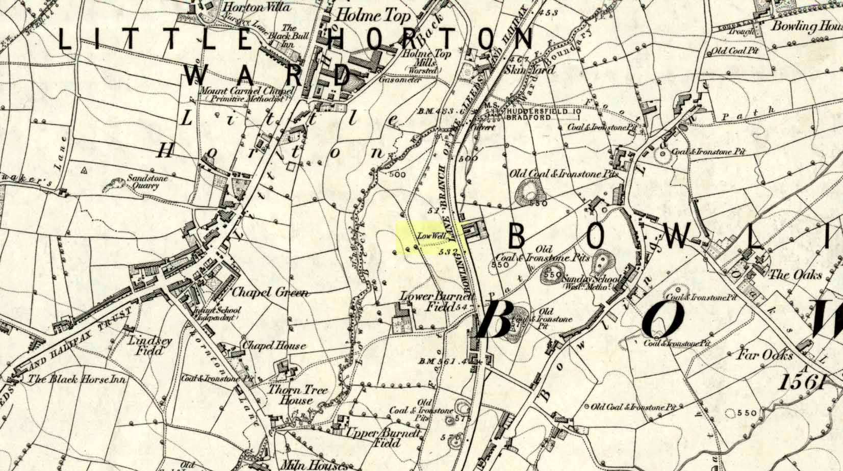
Low Well on 1852 map
Along the now-lost Low Well Road between Little Horton and West Bowling, could once be found this innocuous-sounding water source. Shown on the 1st OS-map of the area in 1852, the site was deemed to be little other than a ‘public well’. At the end of the 19th century, a small well-house was built over the waters; and the years following that saw its complete demise. Its name you would think relates to a position in the land, but the dialect word low, or lowe can mean “a flame, blaze, light, glow”, it can also refer to a prehistoric tomb. However in this case it most likely derives from “a pond or standing pool”.
…And if some of you wonder why I have given this so-called Public Well the provenance of being a “sacred well”, please keep reading…
Folklore
Although it was deemed a simple ‘public well’ by historians and the public water authority, local folk knew there was much more to it than that! In the Bradford area, this innocuously-named Well is the most promiscuously supernatural of all water sources, with a hidden history of magickians, ghosts and black dogs haunting its once ancient flow. It was a site remembered as having oracular powers, where local people used it in scrying the future. For such powers to work here, one had to gaze into the waters as they stilled at 6 o’ clock in the morning – a common time used by ritual magickians for the invocations of spirits.
The Bradford historian William Scrotum (1889) told us that in the 1860s, local people reported that the phantom black dog—or Bharguest as it was known—with its glowing red eyes, was seen coming out of the well after dark and scaring people half out of their wits. Very soon people would not even venture out after dark for fear of encountering this great harbinger of Death. Several years passed before local people called upon the abilities of a ritual magickian in the hope that he could lay the ghostly hound and bring peace and stability back to the hearts and minds of those living hereabouts. Eventually, after much work, the magickian exorcised the waters and cast the black dog back into the depths of the Earth from whence it had come and, to this day, sightings of the spectral hound have stopped.
Water sources that possess ingredients of hauntings, magic and oracular properties are universally ascribed as ‘sacred’ in one way or the other. In pre-industrial times I have little doubt that, amongst the animistic pantheon of local Bradfordians, this was no exception.
References:
Scruton, William, Pen and Pencil Pictures of Old Bradford, Thomas Brear: Bradford 1889.
Wright, Joseph, The English Dialect Dictionary – volume 3, Henry Frowde: London 1902.
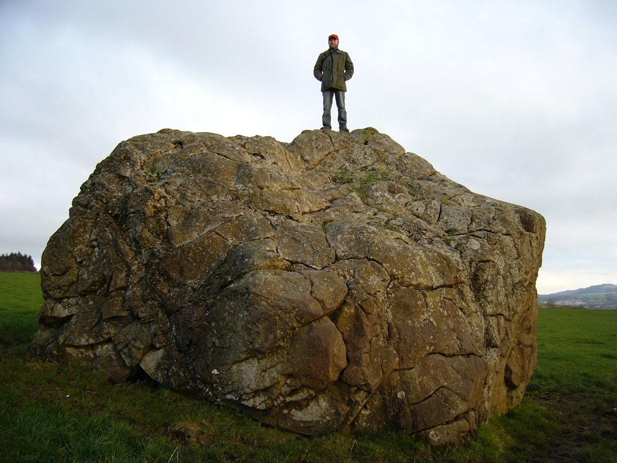
On the outer southern edge of Kilbarchan parish—right near the ancient boundary line itself—this giant stone of the druids is seems to be well-known by local folk. Located about 40 yards away from the sacred ‘St Bride’s Burn’ (her ‘Well’ is several hundred yards to the west), it was known to have been a rocking stone in early traditions, but as Glaswegian antiquarian Frank Mercer told us, “the stone no longer moves.” The creation myths underscoring its existence, as Robert Mackenzie (1902) told us, say
“This remarkable stone, thought by some to have been set up by the druids, and by others to have been carried hither by a glacier, is now believed to be the top of a buried lava cone rising through lavas of different kind.”
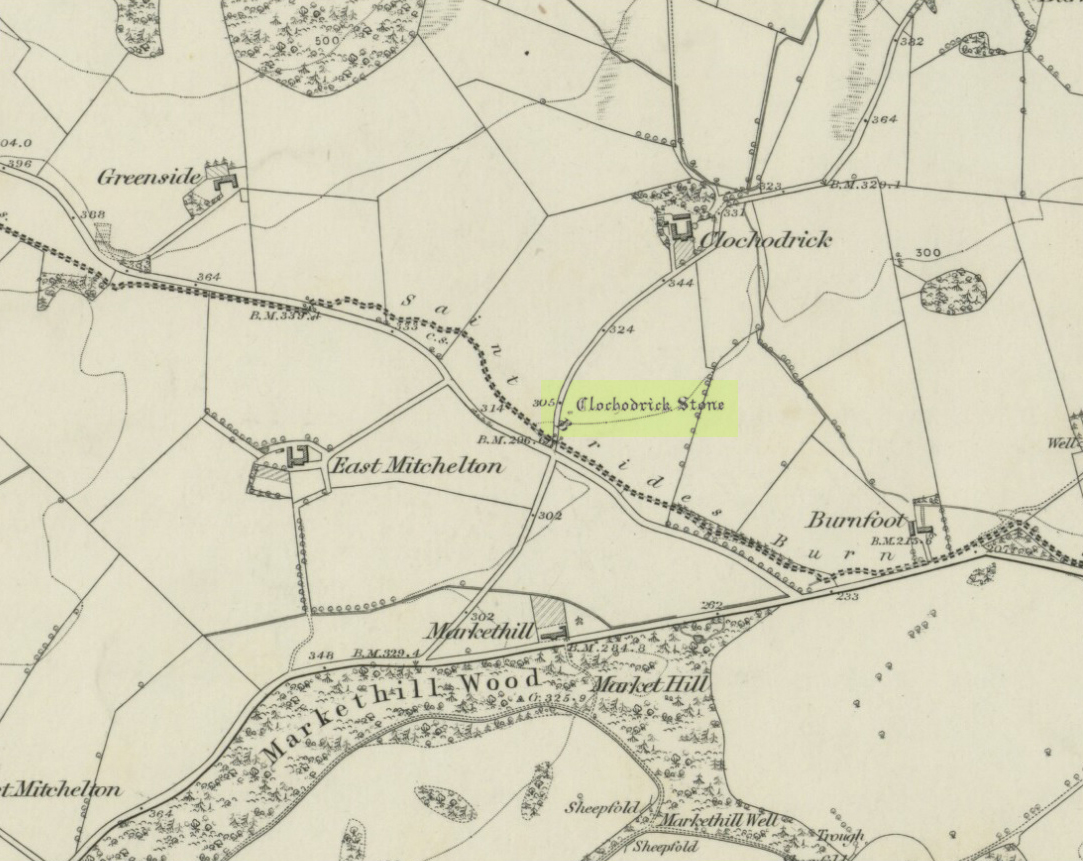
Clochoderick Stone on 1857 map
The site was highlighted on the first OS-map of the area in 1857, but the earliest mention of it seems to be as far back as 1204 CE, where it was named as Clochrodric and variants on that title several times in the 13th century. It was suggested by the old place-name student, Sir H. Maxwell, to derive from ‘the Stone of Ryderch’, who was the ruler of Strathclyde in the 6th century. He may be right.
Folklore
Folklore told that this stone was not only the place where the druids held office and dispensed justice, but that it was also the burial-place of the Strathclyde King, Ryderch Hael.
References:
Campsie, Alison, “Scotland’s Mysterious Rocking Stones,” in The Scotsman, 17 August, 2017.
MacKenzie, Robert D., Kilbarchan: A Parish History, Alexander Gardner: Paisley 1902.
Acknowledgements: Big thanks to Frank Mercer for use of his photos and catalytic inception for this site profile.
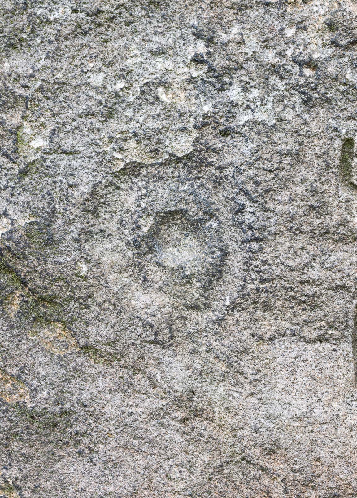
The crags of Little Almscliffe are today peppered with many modern carvings, such as are found on many of our northern rock outcrops. Yet upon its vertical eastern face is a much more ancient petroglyph – and one that seems to have been rediscovered in the middle of the 20th century. When the great northern antiquarian William Grainge (1871) visited and wrote of this place, he told us that, “the top of the main rock bears…rock basins and channels, which point it out as having been a cairn or fire-station in the Druidic days; there are also two pyramidal rocks with indented and fluted summits on the western side of the large rock” – but he said nothing of any prehistoric carvings. Curiously , neither the great historian Harry Speight or Edmund Bogg saw anything here either.
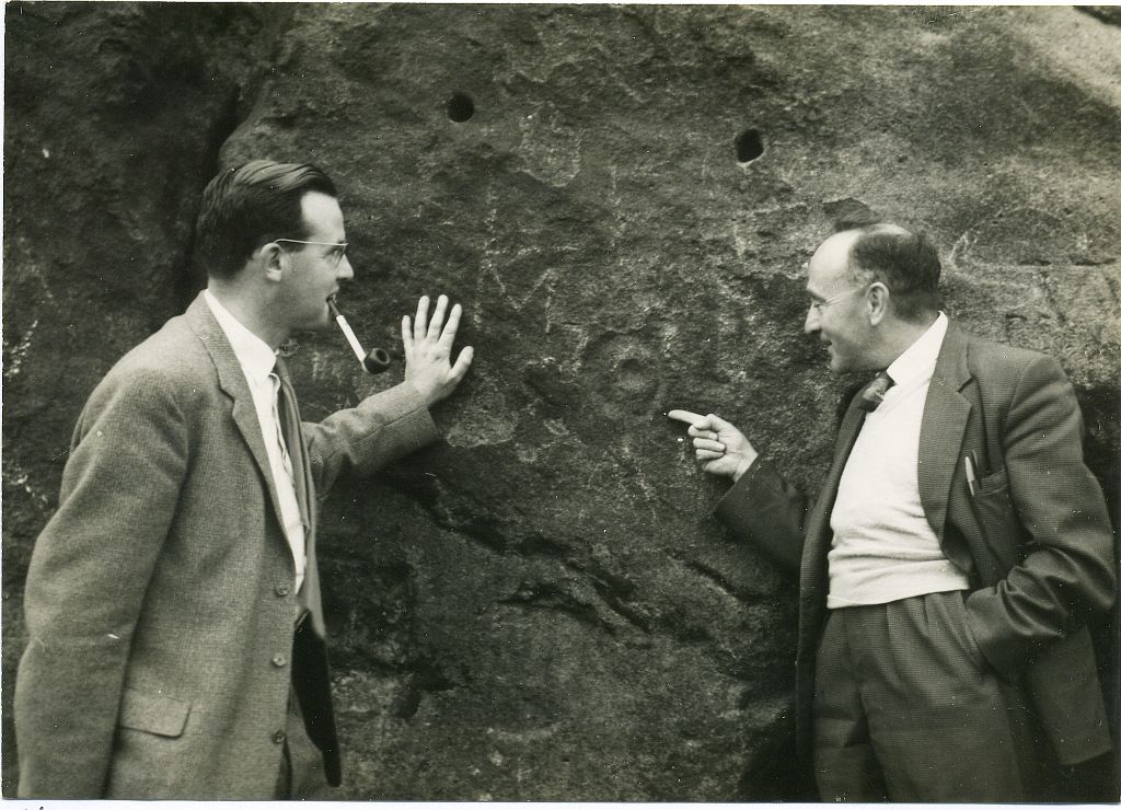
Stuart Feather & Joe Davies here, c.1955Cup&Ring, left of ‘door’ (photo by James Elkington)
This singular cup-and-ring design seems to have been reported first in E.S. Wood’s (1952) lengthy essay on the prehistory of Nidderdale. It was visited subsequently by the lads from Bradford’s Cartwight Hall Archaeology Group a few years later; and in the old photo here (right) you can see our northern petroglyph explorer Stuart Feather (with the pipe) and Joe Davis looking at the design. In more recent times, Boughey & Vickerman (2003) added it in their survey of, telling briefly as usual:
“On sheltered E face of main crag above a cut-out hollow like a doorway is a cup with a ring; the top surface of the rock is very weathered and may have had carvings, including a cupless ring.”
Close up of design
Indeed… although the carving is to the left-side of the large hollow and not above it. Scattered across the topmost sections of the Little Almscliffe themselves are a number of weather-worn cups and bowls, some of which may have authentic Bronze age pedigree, but the erosion has taken its toll on them and it’s difficult to say with any certainty these days. But it’s important to remember that even Nature’s ‘bowls’ on rocks was deemed to have importance in traditional cultures: the most common motif being that rain-water gathered in them possessed curative properties.
References:
Bennett, Paul, The Old Stones of Elmet, Capall Bann: Milverton 2001.
Bogg, Edmund, From Eden Vale to the Plains of York, James Miles: Leeds 1895.
Bogg, Edmund, Higher Wharfeland, James Miles: Leeds 1904
Cowling, E.T., Rombald’s Way, William Walker: Otley 1946.
Grainge, William, History & Topography of Harrogate and the Forest of Knaresborough, J.R. Smith: London 1871.
Parkinson, Thomas, Lays and Leaves of the Forest, Kent & Co.: London 1882.
Acknowledgements: Huge thanks to James Elkington for use of his fine photos on this site.
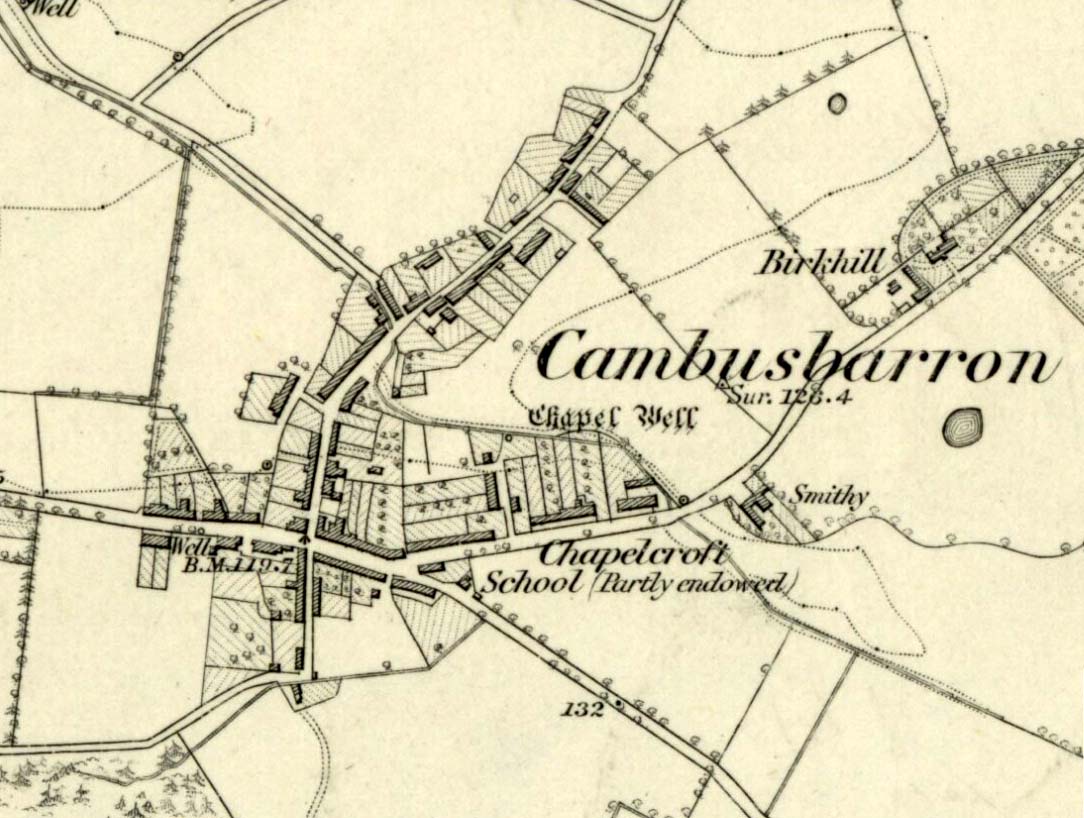
Along the Main Street in Cambusbarron, walk down Mill Hill for a hundred yards or so, to The Brae. Just here, a paved footpath goes to the right. Walk along here for about 120 yards until you reach a small footbridge crossing the stream. On the other side of this bridge you’ll notice a notice board and a sign. You’re here!
Archaeology & History
Today, all that remains of this spring of water that was sacred in the animistic pantheon of our ancestors, is a notice board and an epitaph, reading “Site of the Chapelwell (or Christ’s Well)”; but in times past this simple spring of water was a place of considerable activity. Not only did the local people of Cambusbarron get their water supply from this (and others close to the Main Street), but it was also a place of ritual and reverence. We know this from early church accounts—most of which were complaints about the traditions performed by local people, in contravention to the christian cult.
J.S. Fleming’s old drawing
The best account of the site is found in J.S. Fleming’s (1898) work, in which we find it also referred to as the ‘Christ’s Well’. This attribution adds further mystery and controversy regarding another Christ’s Well a few miles away at Blair Drummond, whose position by the academic community is questioned by local historians. Be that as it may, Mr Fleming’s words on this Chapel Well are worth reading. He wrote:
“the most famous of all the Stirling Holy Wells, was, early in this century and is still, known by the name of ‘Chapel Well,’ and its water, up till a recent date, was used for domestic purposes by the villagers. It originally consisted of a square, stone-built, open well, with parapets, but its walls are now built up and roofed, and it has a door, now shut up, however, and the well closed by the sanitary authorities of the district. The well is situated on the brink of what we assume to be Glenmoray Burn, here crossed by a rustic wooden bridge in a part of the Chapel Croft garden, containing the alleged site of the chapel, from which it is distant a few feet. The stump of an ancient thorn is shown on the right hand of the sketch. The overflow of water empties itself into the adjoining burn. The site of this famous well has been so variously described as to almost challenge its identity, but the authorities examined, all, with one single exception, afternoted, virtually agree in its situation:
“1) Sutherland, about a hundred years ago, writes: “Not far from St. Thomas’ Well there is another, on the farm of Chapel Croft, called ‘Christ’s Well,’ of great repute, and visited by women, etc.”
“2) Dr. Rogers, later, after referring to the Chapel of Cambusbarron, says ”two of the three wells connected with the establishment still exist near its site by the margin of Glenmoray stream.”
“3) Another writer says: ‘”Christ’s Well,’ now called ‘ Chapel Well,’ is at bottom of a small dell called Glenmoray, immediately adjoining Cambusbarron, and there is a tradition that here the water was got for the religious services at the Battle of Bannockburn, one redeeming quality of the superstition which would consecrate its water.”
“4) A writer, over the initials “S.I.,” in the Stirling Observer of 27th September, 1866, says: “Within its Chapel King Robert the Bruce partook of the sacrament on the eve of the Sabbath preceding the Battle of Bannockburn, and its sacred font was the resort at Beltane of the superstitious of a former age, as may be seen from extracts from kirk session records.”
“These all agree that ‘Christ’s Well’ was situated not far from St. Thomas’ Well, on Chapel Croft; that it and other two wells existed some few years ago near the site of the Chapel, on the margin of Glenmoray stream, by the name of “Chapel Well”; ” is situated in a small dell called Glenmoray, and is immediately adjoining Cambusbarron; and that it retains, and is presently known by, no other name than the “Chapel Well.” Further, a small distillery, now removed, situated a few yards from the Chapel on this burn, taking its name from the glen and burn, was called Glenmoray Distillery…”
“However, a writer in the Stirling Observer of 7th September, 1871, in an article on “Touch Glen,” says that not far from the road leading to the three reservoirs on Touch Hills, two of the three Wells connected with the Chapel (which, he states, is 1000 yards distant from Gartur Lodge) still exist, and may be seen near the brink of a little burn which trickles from the miniature glen of Glenmoray, visible on the hillside just below the lowest reservoir. This burn is crossed by a small stone bridge on the main road, and is known as “Johnnie’s Burn.” These Holy Wells, including Chapel Well, would thus, according to this writer, be about a mile, if on “Johnnie’s Burn,” and if near the lower reservoir, on Touch Hill,’ fully a mile and a half from Chapel Croft and the Chapel…
“…The Church dealt severely with the devotees—principally women—who resorted to the virtues of “Christ’s Well,” as is shown by the session records, from which we make a few extracts: —
“July 12, 1610. — The quhilk day compeirit Grissal Glen and Marioun Gillaspie quha for ther superstitione in passing in pilgrimmage to ‘Christe’s Well’ as they confessit the last day ar ordeinit to mak publick repentance the next Sonday in lining claithis.”
” 1 June, 1630. — The quhilk day compeirit Elspet Aiken, spous to Anclro Cuyngham, tinckler; Jonet Harvie, William Huttoune, cutler; Margaret Mitchell, dochter to Alex Mitchell; Jonet Bennet, dochter to James Bennet, cuick; James Ewein, son of John Ewein, wobster, Margt. Wright, James Watsoune, who confessis passing in pilgrimmage to ‘Christe’s Well’ in Mai, and thairfoir they ar ordeaned to mak publik repentance the nixt Sabbat in thair awin habeit, under the paine of disobedience.”
” Lykway I, Mr. Patrik Bell, am ordeaned to desyre the breithren of the Presbyterie to appoint ane actuale minister for to preach upon Sonday nixt for to tak ordour with the said persounes above writen.” (Note — This offence seems a mere ploy of young people observing May morning, as is done at the present day on the first of May, and the responsibility “of asking” an “actual minister’s aid” to take “order” with the accused seems treating the offence too seriously.)
“6 October, 1631. — The quhilk day compeirit Jonet Norbell, in Cambusbarron, for going for water to help her sick son; and Jonet Main, in Cambusbarron, going to ‘Christe’s Well’ for water for help to her bairns; “and for another offence are ordained” to sair the pulpit on Sonday nixt in her ain habit to mak repentance.”
Mr Fleming seemed to think the traditions of Mayday a healthy thing and wrote well of local traditions, speaking of the healing virtues of the dew on May morning, used by people all over the country; also remembering a song that would be sung in honour of “the delightful custom of maying”:
I, been a rambling all this night,
And some time of this day ;
And now returning back again,
I brought you a garland gay.
Why don’t you do as we have done
The very first day of May ?
And from my parents I have come,
And would no longer stay.
Chapel Well on 1865 map
Modern plaque at the site
The fact that Mr Fleming cites the Chapel Well to be known locally as the ‘Christ’s Well’ needs to be remembered when you visit a site of the same name 5 miles northwest of here at Blair Drummond. It was a place of considerable renown and much used by local people for a variety of indigenous rites and customs for many miles around. The ancient Scottish practices were still very much alive…
References:
Fleming, J.S., Old Nooks of Stirling, Delineated and Described, Munro & Jamieson: Stirling 1898.
MacKinlay, James M., Folklore of Scottish Lochs and Springs, William Hodge: Glasgow 1893.
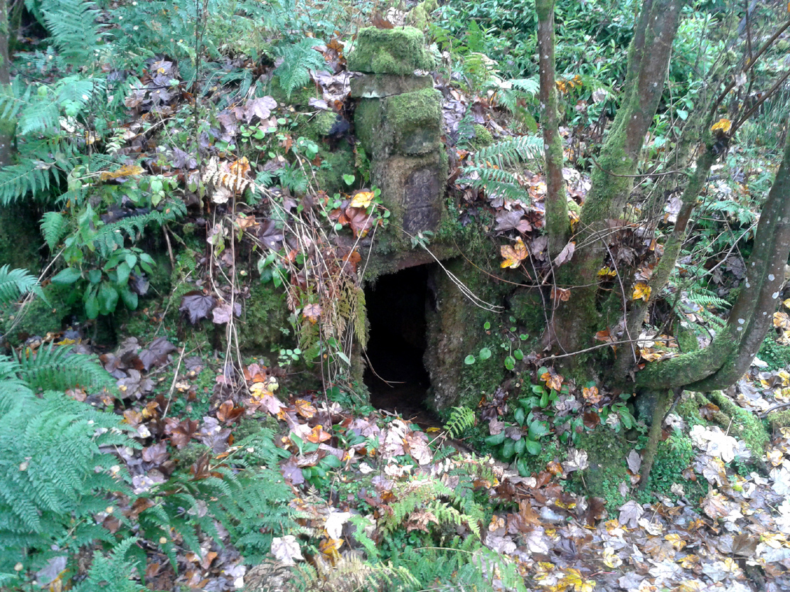
Along the A84 Stirling-Doune road, watch out for the minor Cuthill Brae road to the caravan park. Go past the caravan place (ignore the grumpy fella there who tells you “this is private”) over the cattle grid and walk immediately to your right, along the top of the field, going through the first rickety gate 150 yards along. Follow the overgrown circular woodland path around, and as you see the Safari Park and Blair Drummond House ahead of you, walk just another 100 yards or so along the path until you reach a boggy hollow in the ground with an old small building inside it. That’s it!
Archaeology & History
For a variety of reasons, this little known site hiding away and all but lost in the mythic lives of homo-profanus, is one of the most important sites in the Stirlingshire region due to it being a site where animistic rites and practices were regularly enacted by local people in the 15th century—and before, no doubt! We know this because we have a veritable list of, albeit, ranting christian accounts from some early church records, that were thankfully transcribed at the end of the 19th century by local writer R.F. Menzies. (1899) Despite the seemingly “christian” title given to this old well, the local people used it extensively for their magick, their traditions, their healing, their solace and their spirituality.
The waters within…
Before we start, it’s important to note that the geographical position stated here, in the trees at Blair Drummond, is taken from the reference at Canmore, who do not cite a literary source or oral account which affirms this to be the exact spot. I mention this as there has been a problem regarding its exact location, not only by Mr Menzies, but also in the texts by MacKinlay (1893) and Morris (1982), each of whom said that the well was in the parish of Menteith, several miles to the west. In Menzies (1905) history of Logie parish, a footnote is added in relation to the position of the site:
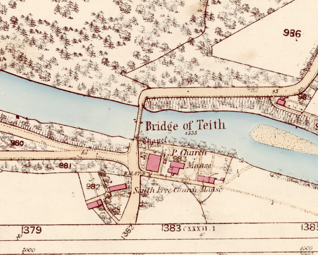
“Mr W.B. Cook considers that ‘there is no authority for saying the well was in Kincardine-in-Menteith. An exhaustive enquiry by me has narrowed its locality down to two possible places, viz. Walton (i.e., well-town) and Bridge of Teith, both sites of pre-Reformation chapels, in the parish of Kilmadock. It is as nearly certain as can be that Christ’s Well in Menteith was near the ancient chapel at Bridge of Teith, the remains of which—along with the well itself—are still to be seen.’”
This would therefore differ from the position presently cited by Canmore and the official records. The ruins of the chapel described by Mr Cook were noted by the Ordnance Survey team at the Bridge of Teith when they visited in 1862 and it was highlighted on their maps four years later. No “well” was noted however—and although we have Mr Menzies (1899) to thank for the presently accepted spot for this Christ’s Well, we don’t know for certain that this is the correct place. The situation is made more troublesome if we refer to Moray Mackay’s (1984) definitive history of the adjacent parish of Doune. Mr Mackay wrote his work in the early 1950s and, like other local historians, was both fascinated and puzzled about this well. He wrote:
“Many writers in the past have been content with placing this well “in Mentieth” and leaving it at that, but my curiosity was aroused by the fact that more than one reference indicated that it was ‘near to Doune,’ and I set about locating it. It was a somewhat involved process, but I give here a resume of my findings which I published in the Stirling Observer of April 22, 1954.
“Firstly I was led to a paper of modern origin in Blair Drummond Estate Office which gave the site of Christ’s Well as ‘in the fernery at Blair Drummond.’ I found the fernery and also a rather fine well, over which a stone covering has been raised at an unknown date, and thought my quest ended. Later however…a reference in the Register of the Secret Seal, dated 1519, very strongly indicated Bridge of Teith as the site of Christ’s Well, and I was led to a very old well between the back door of the church there and the brink of the river.
“Still later I came across a pencilled note on a map in Doune Lodge Estate Office which read ‘Walton or Christwell unentailed’ as applying to a piece of ground immediately east of the Walton or Welltown site…
“There were, therefore, three alternative sites for Christ’s Well, only one of which had all the qualifications implied in the records as being (1) near Doune; (2) associated with a chapel; (3) in Kilmadock parish. Consequently, I am convinced that the very old, dry-stone well at Bridge of Teith is, in fact, the once-famous Christ’s Well in Menteith.”
Christ’s Well (as ‘Fountain Head’) on 1866 map
Cook & Mackay’s site of Christ’s Well, by the chapel
The site that Mr Mackay and W.B. Cook believe to be the Christ’s Well is 1.5 miles (2.43km) north of the position cited by Canmore (at NN 7221 0121). As if to make things even more complicated, if we travel exactly 5 miles (8.05km) southeast to Cambusbarron, anothersite of the same name (later to be called the Chapel Well and associated with ancient ruins) is found! J.S. Fleming (1898) describes it in some detail.
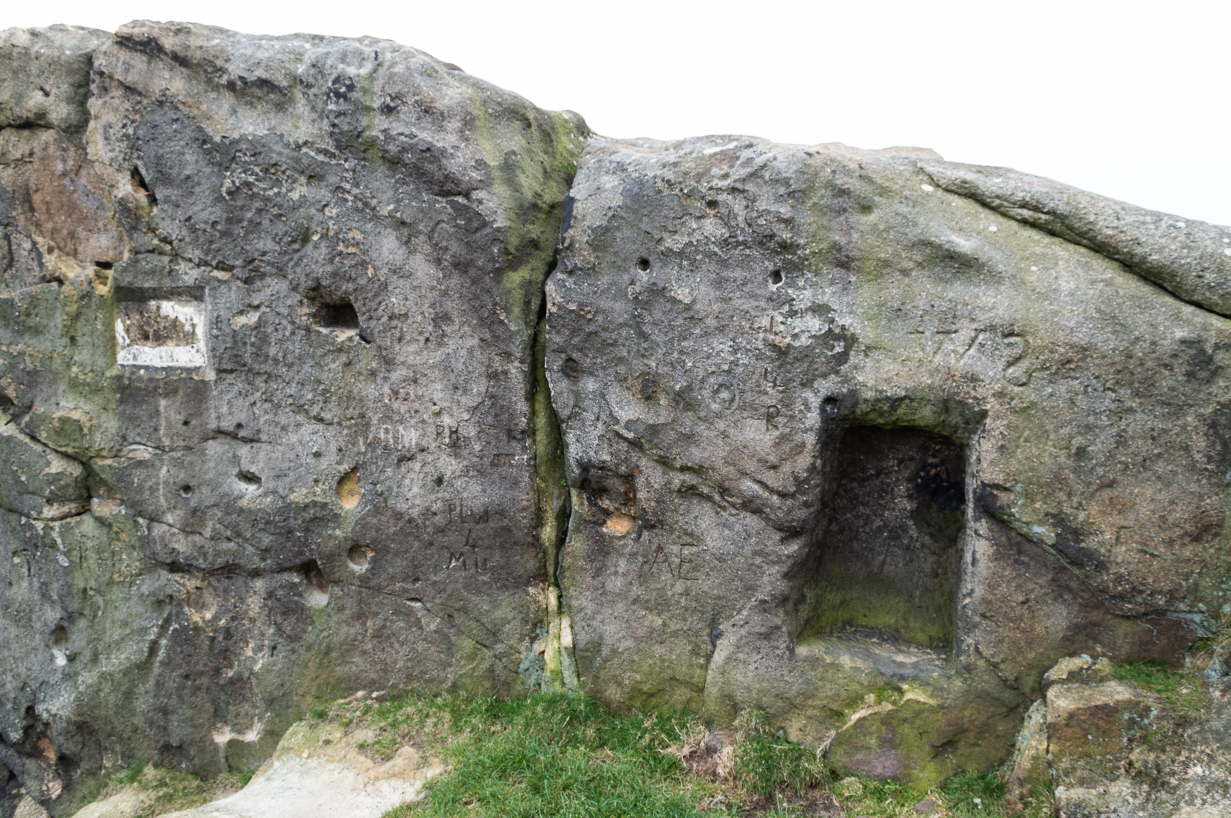
Carved stone dated 1690
Carved stone dated 1678
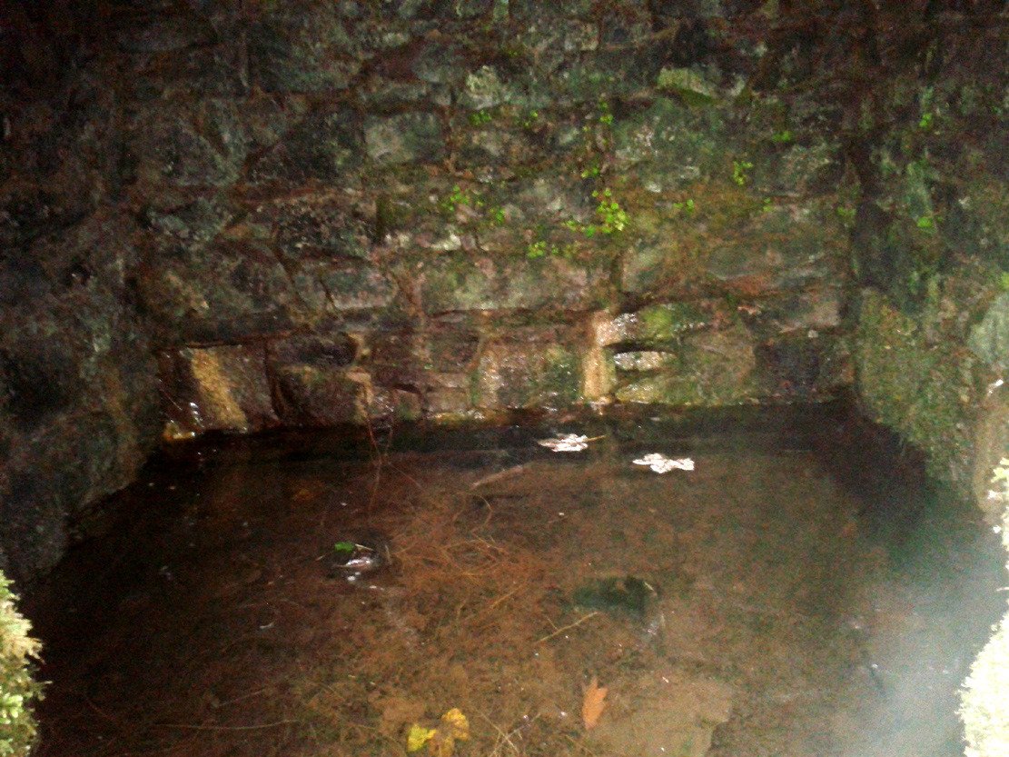
However, for the time being at least, if we assume that the Canmore entry is the real Christ’s Well, if you visit the place you will find an old well-house that has been built over a redirected spring of water which seems to have originally rose just a few yards to the rear of the structure. Above the open front of the well-house—also constructed only a few hundred years ago—are placed two separate inscribed stones: one with the letters “CD ER” and the year 1690 beneath them; and above this an older stone, with the date 1678 etched on it. These may be the dates when an earlier stone structure, whose scattered rocky edges are visible beneath the vegetation around and behind the present well-house, were demolished and then rebuilt. But this is guesswork on my behalf!
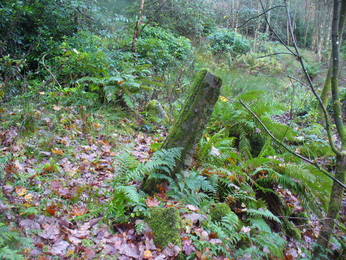
‘Standing Stone’ to the rear
The entire structure is built inside a deep hollow which has no doubt been created and eroded into being by the spring of water itself. On the rise at the back of this hollow is a curious standing stone which, as Penny Sinclair pointed out when we visited here a few days ago, was made out of a fossilized tree. This standing stone is only a few centuries old and either marks the original rise of the spring, or was erected at the same time of the well-house.
Less confusing were the activities performed here by local people in the 16th century—and way before that no doubt. We have a lengthy set of accounts that describe how local people visited the Christ’s Well at the traditional dates of Beltane, Midsummer, etc, performing a variety of rites typical of those found in animistic cultures the world over. Sadly, it was the activities of the incoming christian cult that put an end to such ancient traditions by persecuting local people, as we know it has done everywhere that its virulent tendrils have infested. Anyway, I hope that readers will forgive me citing the entire length of the accounts described by Mr Menzies (1899) about this well; but I think they give us vital insights into traditional healing practices that were just about destroyed by that corrupt institution that is the Church (for ease of reading, I’ve edited and modernized to some degree the repetitive and fragmentary language of the early written accounts):
“The brethren of the Presbytery of Stirling and various Kirk Sessions within the bounds were much exercised and troubled by frequent pilgrimages to a holy well, called Christ’s Well, situated somewhere in the neighbourhood of Ochtertyre, in the parish of Kincardine. For at least thirty years after 1581, pilgrimages were undertaken by certain people, who imagined they could obtain cures for certain diseases at this well. The wonderful thing is that tradition is dumb regarding the exact site of the holy spring. There is a fine spring situated within the grounds of Blairdrummond, which may have been the Christ’s Well, the supposed virtue of which was, on the one hand, so consequential to the public health, and on the other, so troublesome to the Kirk.
“On 20th August, 1581, the Presbytery Record runs: ‘The brethren understands that a papist pilgrimage began of late at the Christ’s Well, and ordains every minister within their own bounds to try those persons who resort to it, and to call them before the particular Sessions that they can be convicted…’
“Two years later the evil crops up again, and on 7th May, 1583, ‘The brethren understand that a great abuse by the rascal sorts of people that pass in pilgrimage to Christ’s Well and use it for great Idolatry and superstition that are expressedly against God’s law; and because the Kings Majesty with advice of his three estates of parliament, (there shall be) certain punishments as well as corporal pains as pecuniary sums of money to be executed against such persons; and for execution of which against persons passed and to the said Well, the brethren understands my Lord of Doune Stewart of Menteith has commission given to him to that effect to see that punishment is executed in conformity with the said Act. Therefore the brethren ordains and gives commission to Mr. Andro Zung (Minister at Dunblane), Mr. William Stirling (at Kilmadock), and Michael Lermonthe (at Kilbryde) to pass to my Lord of Doune to treat with him for execution of punishment against the persons according to the said Act and his commission.” On 4th May, 1583, “The brethren ordains and gives commission to the brothers dwelling in Dunblane or any three of them to pass to Christ’s Well this next Saturday evening, accompanied with such persons as you may have to espy which persons comes to the said Well and report the names of such persons you can get to the brethren.’
“On 28th May, 1583, “On which day the brethren understanding that a great number of people have resorted to, and resorts in pilgrimage to Christ’s Well, using yet superstition and Idolatry expressedly against God’s law and the acts of parliament. Therefore…the brethren ordains summons to be directed to charging of such the said persons, whose names shall be given in writing to the clerk to appear before the brethren to answer therefore, to the effect that orders may be taken with them that have been there, to the glory of God and execution of the Kings Majesty’s laws and in example of others to do the same.’
“On 4th June, 1583, “Margaret Wright in Cambus, Janet Kidstoun in Cambus, and Thomas Patersone in Black Grainge” did not appear in courtto answer “for passings in pilgrimage to Christs Well,” and were summoned the second time under pain of excommunication. On 11th June, “Janet Tailzor (spouse to Robert Cowane) in Touch, Marione Watsone in Touch, Marjorie Fargusson in Touch, Margaret Downy in Polmais,” also for the same “compeared not.” (i.e., did not appear in court, as ordered – PB)
“The depositions given in excuse referred to some disease or ailment: One, “confessed she passed there to get help for a soreness in her side and confessed she passed about the well and prayed to Christ’s Well on Sunday and drank of the Well and washed her side with the water thereof and left behind her a sown thread” (as offering). Another, “passed….because she was sick in her heart and in her head and lipnit (trusted) that the Well would have helped her sicknesses…and she passed about the Well and cast the water over her shoulder and drank of it and left one piece of silver behind her.”
Ten years later several cases of pilgrimage to Christ’s Well come before the Presbytery. 22nd May, 1593, “On which day the brethren are credibly informed that Malcolme Alexander in Menstrie, James Baird at Muckart mill, and Jonet Mairschell, his spouse, passed in pilgrimage to Christ’s Well and visit superstition and Idolatry thereat. Therefore the brethren ordains them and such others who have done such like within their bounds to be summoned to answer for the same and unduly discipline them therefore under the pain of disobedience; and ordains each Minister to travel with one or two gentlemen in his parish to pass to the said Well on Saturday evening and espy what persons come there and what they do and relate the information to the minister, and see that each minister take Inquisition in his own Eldership what passes at the said Well and relate them to the presbytery.”
29th May, 1593, *On which day the summoned James Baird…to answer for passing in pilgrimage to Christ’s Well appeared in court, the said James, and confessed that through earnest persuasion of his wife (who was also moved to be there by other people), he passed with her to Christ’s Well on Saturday the 12th day of May instant, and that she two hours before the sun went down on Saturday evening drank of the said well and washed her legs and arms in it and did no fairer; he did nothing with the water, for his errand there was only with his wife who was persuaded to go there for her healing by Issobel Scotland. He confessed that there was at the said Well this year Ewffam Wilsone in Blairhill. Alaster Leany who was some time servant to Alexander Ezat in Culross. He confesses that David More is he whom bears aqua-vitae and being oft times in David Fargus house in Alva, said to his wife that there was money brought to that Well…; and that Crystie cadzear in Alva confessed to him when he and his wife came home from the well, that he was three or four times at Christ’s Well and was the better, he confesses that his wife is sick and cannot come to court this day and obey the summons and therefore desires that his excuse for her may be admitted. The brethren having considered the said James Baird’s fault, ordains him to make repentance therefore in Dollar kirk as it is adjacent to him the next Sunday in secclayth (???), and that the plaintiff above written be summoned to answer for the said offence under the pain of disobedience.”
Another case falls to the ground for want of proof. On 5th June, 1593, “One summons upon Malcolme Alschunder in Menstrie…to answer for passing to Christ’s Well and using superstition and Idolatry there at, but there is no appearance in court. He appears on 12th June, “And denies that he passed to Christ’s Well or was bewast (to the west of – PB) Teith at any time in May, and therefore the said matter remains to be proven.” On 3rd July, “Inquisition being taken, asks if there be any witnesses that can prove Malcolme Alexander was at Christ’s Well, there is none found, and therefore it is thought good to proceed no farther against him for the said offence.”
On 14th May, 1595, James Duncansone in Fossoway, and Helen Jameson, his spouse, are charged to answer “For superstition and Idolatry in passing to Christ’s Well in pilgrimage… The said Helen confesses she passed to Christ’s Well through the year to get her bairns eye healed which was blind a month before. She washed his eye thrice with the water thereof, and alleged that the bairn saw or he come home; and confesses that she passed there this year also to give thanks for the benefit she received the year preceding, and left a shirt of the bairns behind her, which was on the first Sunday of May… The said James Duncansone denies that he passed to the said well with her, but only to Ochtertyre, where he was all night—well the morning that she come to him, and then they passed together to Dunblane. The brethren finds him also culpable as his wife in her said fault, seeing he has known thereof and past with her to Ochtertyre, which is the most part of the way, where he ought and should have stopped her, and therefore they are ordained to make public repentance in linen clothes the next three sabbath days bare-footed.”
James Duncansone’s wife appears to have refused to obey the Presbytery, and on 16th July, 1595, she is summoned to appear in court, “beand chair- git as said is to heir and sie hir self decernit to be excommunicated for not completing the injunctions to her for passing in pilgrimage to Christ’s Well two different times, who being oft times called, appeared not. Therefore the brethren ordains her to be summoned de novo to the effect aforesaid with certification.”
“As no further mention is made of this woman’s case, she must ultimately have satisfied (them). The resorting to this well comes before the Presbytery (again) on 23rd April, 1600: ‘The brethren being credibly informed of the great abuse and superstitions of visits by many people at Christs Well, namely in the night immediately preceding the Sabbaths in the month of May; for remaid thereof the brother of the Ministry within their boundaries are ordained that publicly in their kirks the next Sabbath inhibit and forbid in the name of God and his kirk that no persons shall pass to the said Well… And to the end that such abusers that go there may be stopped from their superstition. The brethren ordains the ministers of Kilmadock and Kincardine with the special gentlemen of their flocks, to await vicissim (in return) at the said well on the night preceding the Sabbath during all the month of May; and to that effect the brethren ordains the clerk to write in the names (of visitors) to the gentlemen of the said parishes.’
“The members of Presbytery were determined to put a stop to such superstitious practices, and ere long, their efforts met with success. In the meanwhile however, isolated cases came before them for judgment . Thus on 29th July, 1601, “Jonet Rob in Pendreich” is summoned to appear to answer “for disobedience to the elders of her parish church of Logie, conjoined with slandering the kirk by passing in pilgrimage to Christ’s Well.” She does not appear, and is summoned pro tertio, but apparently having satisfied the “eldership” of Logie, the matter is not again referred to.
“The last mention of Christ’s Well is at the meeting held on 1st July, 1607, when a batch of nine penitents from the parishes of Airth and Bothkennar, “Compare and confess they were at Christ’s Well to heal their diseases, and took some of the water and left something behind, every one of them, at the well. The brethren finds that they have committed superstition and have dedicated to Satan that thing they have left behind them (at the well), and are therefore ordained to make public repentance at the next adjacent kirks of Airth and Bothkennar.”
Menzies noted another mention of people using the waters here a few years later, telling:
“As late at June 6, 1630, the Kirk Session Records of Stirling contain an entry, where five women and two men, “confesses passing in pilgrimage to Christ’s Well in May, and therefore they are ordained to make public repentance at the next sabbath, in their own habit, under pain of disobedience.”
In these records we can clearly see that a bunch of incoming religious fanatics have arrived and set themselves up to engage with the Scottish people so as to undermine and destroy the indigenous traditions and practices prevalent at that time, by imposing laws against them which were not for the benefit of the local people. Indeed, the laws were preposterous! The initial description that the rituals performed by the local people were ‘papist’ in nature is, of course, a cover—as was the name, Christ’s Well—in an attempt to avert the christian cult from attacking their traditional places of healing and rites. This failed—but at least we have the accounts describing the outlandish presbyterian impositions.
Penny sits guarding the well
However, even with these accounts it is difficult to say with any certainty where the original Christ’s Well emerged. The position Penny Sinclair and I visited, as marked on the modern OS-maps, is congruous for rites of solitude as described in the church accounts; and a distinct genius loci feels to be just beneath the surface. However, it is difficult to see how people visiting here would have been noticed by the christian enforcers, as it is away from prying eyes. However, if the well was at the Bridge of Teith, it would explain how so many people were “caught in the act” of performing their rites, as an old chapel was adjacent to the well. More research is required, obviously…
In the meantime, I truly recommend visiting this place to those who enjoy the quietude of sacred sites. Tis a fine secluded place—although it could do with a good tidying-up to free its fresh waters once again…
References:
Bennett, Paul, Holy Wells and Healing Springs of Stirling and District, forthcoming
Bradley, Ian, Water—A Spritual History, Bloomsbury: London 2012.
Going north-eastish from the city of Perth, take either the A93 or A94, turning west along the A93 a mile south of Guildtown, or east at Balbeggie on the A94, until you reach St. Martin’s hamlet and park up just below the church opposite the old cottages. Walk up the track below the cottages (not the one above them!) for ⅘-mile (1.35km) [past the ruined Cupar Stone Circle], and where the land has levelled out and in the huge flat field on your left, you’ll eventually reach a gate and see the odd-looking ‘rock’ about 250 yards away in the middle.
Archaeology & History
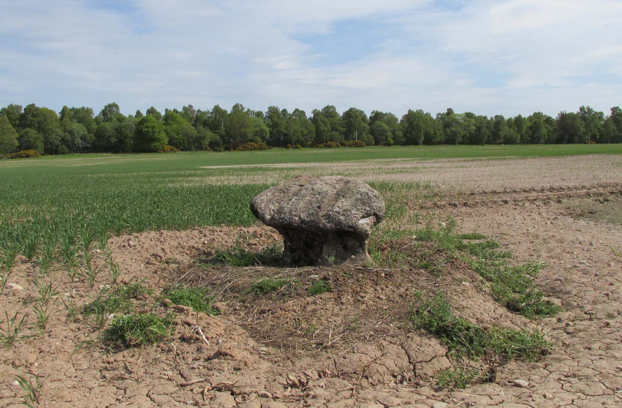
A fungal morel turned to stone
In a quiet and little-known parish that was once littered with about a dozen stone circles, there remains a most curious and fascinating stone which, in earlier days, was to be seen on the open moorlands at this spot. The area was then forested and then the agriculturalists came with their farming and destroyed the forests, leaving the old stone as it presently stands, isolated, above the hamlet of St. Martin’s to the south. Although it was described in the 19th century as being “four feet high”, it stands barely three feet tall, is very curiously-shaped—just like a morel mushroom from some angles—and in the middle of an extensive piece of flatland where the crops barely grow.
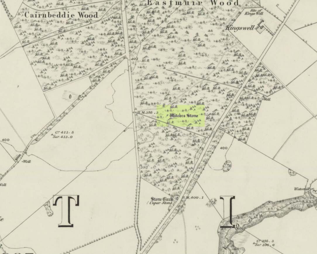
Witches Stone on 1866 map
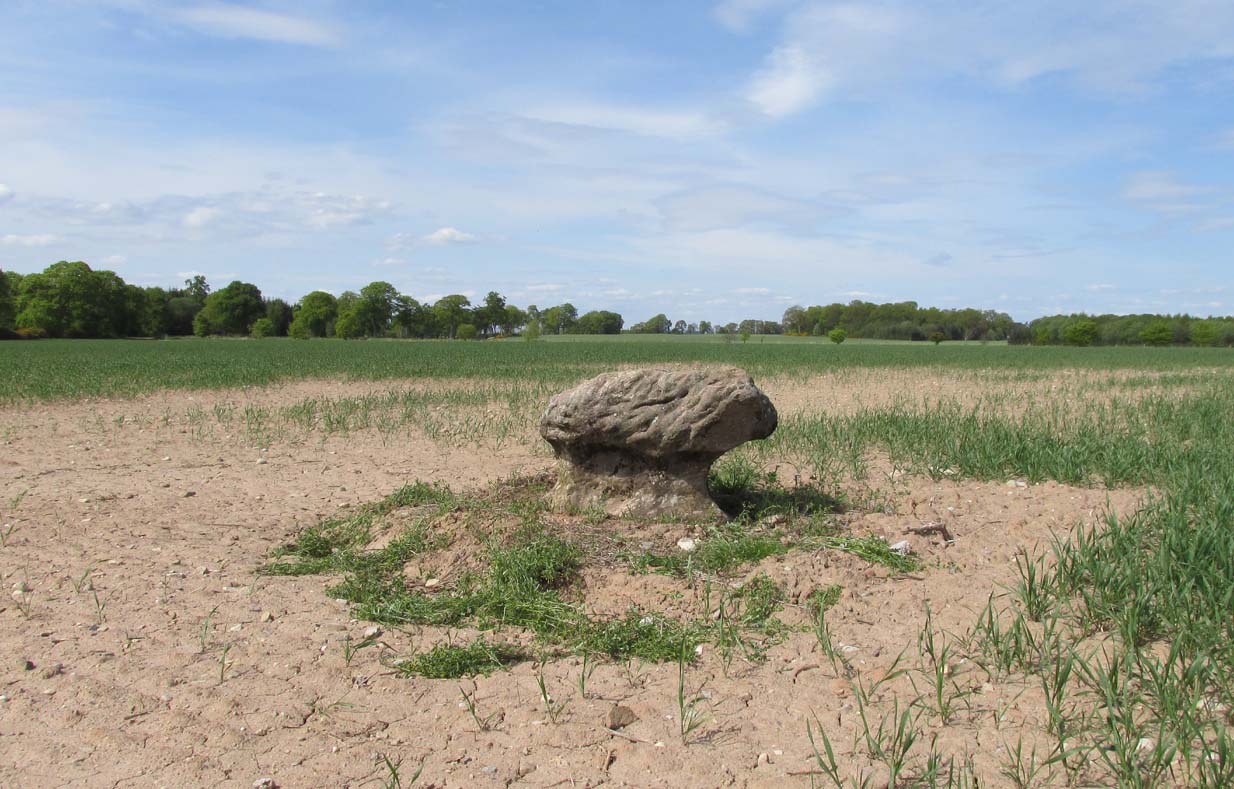
Witches Stone, looking west
The stone was highlighted on the first OS-map of the parish in 1866, showing it in the woodland plantation of Eastmuir. It may have been some sort of northern outlier related to the now-destroyed stone circle of Cupar 400 yards south; and if this was the case, its position in the landscape relative to the circle would give the Witches Stone an airt (virtue ascribed to cardinal directions) in the cycle of the year that relates to darkness and death. (Perhaps oddly—perhaps not—the name of parish St. Martin’s relates to that dark period in the calendar, as St. Martin’s day in the old calendar was Samhain or Halloween: old New Year’s Day, when the spirits of the dead moved across both land and skies.)
It was erroneously described by the Canmore lads as being little more than “a glacial erratic”, but the stone here is quite earthfast; and their idea that “its peculiar shape has probably been caused by wind erosion”, is also somewhat dubious considering the shape of other monoliths and megalithic rings in the region. The stone has an appearance similar to some Bull Stones, where the animal was chained to rocks such as this and then baited by dogs, although I can find no such lore here. Indeed, the history and archaeology of the stone seems all but silent. Its folklore however, would have the Shakespearian romanciers amongst you flocking to the place…
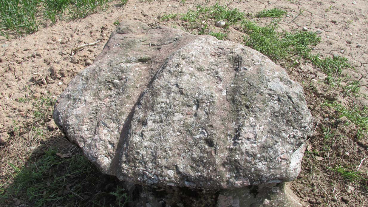
Deep grooves atop of the stone
The top of the stone has some very distinct and deep-cut lines running across it at angles, and has the appearance of being cut into at some time in the dim and distant past. By whom, and for what reason, we cannot say.
Folklore
William Richie (1845) told us that in the 11th Century when Scotland was having to deal with the english disease of stealing land and spreading its violence, King MacBeth—whose castle stood within this parish at Cairnbeddie (NO 1498 3082)—took that advice of two witches, and that
“they met him one night at a place still called ‘the Witch Stane’ (where a remarkable stone still stands), about a mile from his old residence, and warned him to beware, ‘Till Birnam forest come to Dunsinane.’”
The 1860 Name Book told us that,
“The Moor where the witches met, which is in St. Martins Parish is yet pointed out by the country people, and there is a stone still preserved, which is called the Witches Stone.”
References:
Scott, Aleander, St. Martin’s and Cambusmichael, Perth 1911.
Richie, William, “St. Martins and Cambusmichael,” in New Statistical Account of Scotland – volume 10: Perthshire, William Blackwood: Edinburgh 1845.
Acknowledgements: Huge thanks to Prof Paul Hornby for showing me this site. Cheers matey!
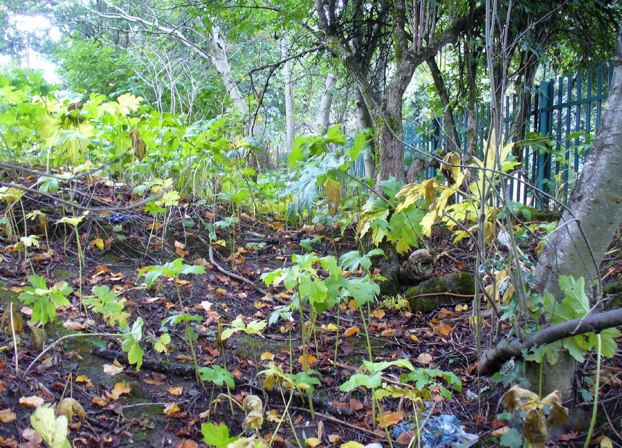
Site of St Conval’s Well, off-centre beneath the tree
This all-but-forgotten holy well was becoming nothing but a faded memory even in the middle of the 19th century. Excluded from all of the previous Scottish holy well surveys, the site is mentioned in George Campbell’s Eastwood (1902) where, in his description of the obscure saint, St. Conval or Convallus—to whom Eastwood parish was dedicated—the position of the well is mentioned. When St. Conval first came to the area, said Campbell,
“The particular spot which the saint selected for his cell would be determined, as was so commonly the case, by the then remarkable spring which can still be traced in the lower part of what was the glebe before the excambion in 1854. Within the memory of man, even of my own, as I resided for a year in the old manse, before its removal from the early site, this well, as stated in the last Statistical Account, discharged about eleven imperial pints a minute, and was perennial, affected neither by drought nor rain. Up to that date the water was sufficiently abundant to supply the manse and all the families in what was still a bit of a hamlet, the remains of the Kirkton, as it was formerly called. But coincident to the removal of the last living remains of an ecclesiastical establishment from the spot, it has well nigh dried-up, through disturbances caused, it is believed, by the working of pits and quarries in the neighbourhood; but it is confidently hoped that what remains of it may be preserved, and a memorial erected over it of the long-departed past, situated as it is within the enclosure of the now extended burial ground. There can be no doubt that in its waters our fathers were baptised when they renounced Druidism, or whatever was their pagan form of faith, and a sacredness would thus naturally attach to it in former times…”
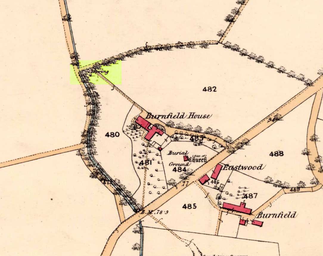
Site on 1863 map as ‘Spring’
When we sought out this well in the furthest corner of the old churchyard—where Ordnance Survey placed the ‘Spring’ on the 1863 map—we were greeted by a completely dried-up site, long since fallen back to Earth, with little hope of it ever resurfacing unless good local people choose to do something. The well was surrounded by excrement and litter and it truly needs a good clean-up and a dig down to bring the waters back to the surface.
In an Appendix to Campbell’s Eastwood, he tells that he came across a map-reference to the site, where it was shown as “St. Ninian’s Well”, but I have been unable to locate this.
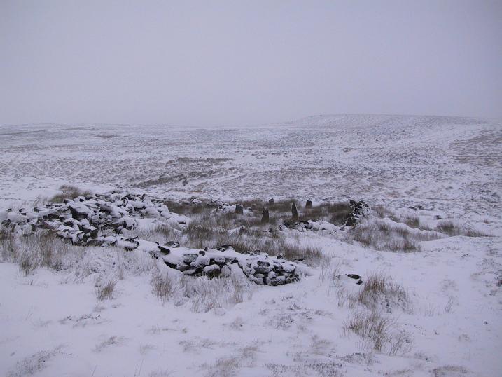
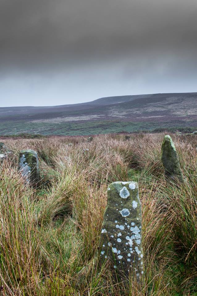
The ruins of Backstone Circle (photo, Richard Stroud)
There are many routes to get here, but this is the one I usually take. From Cow & Calf Rocks, walk up the steep hillside onto the first moorland plain, taking the path right, diagonally, across to the NW as if you’re heading to the Map Stone. From here, looking down at the stream valley below, follow the valley edge up, past the settlement, and then veer down to Backstone Beck and up on the other side till you meet with a footpath and also up in the heather ahead of you, notice the jumbled walling less than 100 yards away. That’s where you need to be!
Archaeology & History
A singular short sentence in Robert Collyer and J.H. Turner’s Ilkley, Ancient and Modern (1885) started it all off, where they told:
“There was still a rude circle of rocks on the reach beyond White Wells fifty years ago, tumbled into such confusion that you had to look once, and again, before you saw what lay under your eyes.”
…..And thankfully this is still what we see today – and in just the area they mentioned.
I’m intrigued to find there’s so much said about this site on the Net and feel I should put my recent feelings about the place to print at last (and after being badgered to gerrit done by James Elkington!). The information about its make-up and the mess it’s in, hasn’t changed since we rediscovered the place on June 3, 1989. Here, amidst the tall grasses and reeds of Juncus effusus and J. conglomeratus, our jumble of megaliths hides within a breakdown of fallen walls, that are thought to have been part of some sheep-fold or a similar animal enclosure (mebbe for the annual sheep-shagging contests that are held, quietly, on these moors each year!).
The name ‘backstone’ itself come from the adjacent beck (slowly depleting as the years pulse by) and is mentioned in the 18th century parish registers. A.H. Smith (1961) informs us that it was the “stream where bakestones were got”, and this was probably a tradition going way way back. The baking stones from the beck may even have been used by the people living in the prehistoric settlements close to the circle.
Stones amidst the reeds
In what looks today like a messy double-ring of stones, it’s likely there was originally just a single ring which has, subsequently, been knocked down and re-used for some form of sheep-fondling sessions—be it agricultural or otherwise! But for the record at least: we have small inner ‘ring’ of four upright stones, re-worked in more recent centuries, between two-and-a-half to three-and-a-half feet tall. Another stone is recumbent. The outer ring is more conspicuous. It consists of at least eight standing stones–seven of which are upright–between three and five feet tall, some of which have been re-worked in more recent times. There are several other stones either recumbent or partly covered by vegetation. The tallest of the stones is 4’11” tall. The outer circle has had at least one of the stones uprooted and used at the base of the dry-stone walling intruding the southwest side of the circle. What appears to be at least two original standing stones are embedded into earthworks on the other side of this wall, one of which was located through dowsing!
The best section of the ring can be seen on its eastern side, where an arc of upright stones between three and four feet high are still clearly in evidence, just inside a raised embankment like that found surrounding the Twelve Apostles stone circle less than a mile away.
A short while after finding the site, we contacted the Ilkley Head of Archaeology Studies, Gavin Edwards, about the circle and he subsequently included the site on one of the tourist-guides to the moors.
Alignments through this circle seem apparent in situ; and although such alignments are intriguing (to me anyhow), it’s the geometric relationship Backstone has with other circles on these moors that is rather notable. It’s position in the landscape plays an essential part in an isosceles triangle formation, 1180 yards [1.08km] from the Twelve Apostles stone circle which, as the centre point, is another 1180 yards from the Roms Law Circle. Odd….
Immediately visible from our ruinous circle across the small valley to the slopes of Green Crag, the Ilkley Archaeology Group spent more than fifteen years excavating the remains of what was initially thought of as a Bronze Age village, but their work here has proved startling, pushing the date of human occupation here into the mesolithic period! Local archaeologist Gavin Edwards opined that the Backstone circle would have been the religious site for the people who lived here. I have to concur. There are also more neolithic and Bronze Age walling, indicative of extended settlements and enclosures, less than 200 yards north of the Backstone Circle, structurally consistent with the remains across the valley at the excavated Green Crag Slack settlement.
Ten yards east of the circle is a small well which only runs following exceptional rainfall. This was probably of some ritual importance to the people who practiced rites here. Geological fault lines run not far away on three sides of the ring and an underground stream is present, quite close to the surface (as indicated by the presence of Juncus conglomeratus and J.effisus), encouraging the preponderance of regular electromagnetic variations: these in particular are likely to have some causative influence on the paranormal events described below….
Fortean History
Since rediscovering this site, a number of bizarre psychophysical anomalies have been experienced and described by more and more people — some of whom were previously very sceptical of such things. Both day and night, no doubt when Moon and water speak their subtle electromagnetic accord, a gathering corpus of all-too-familiar events keep speaking of a most disturbing resident spirit…
We begin on Wednesday, July 12, 1989, sometime around midnight, when an acquaintance and I were spending a few days here to record any possible electromagnetic anomalies at this disturbed ring of stones. We weren’t to be disappointed, as something very untoward raised its peculiar head.
As I sat barely ten yards beyond the tumbled group of stones there suddenly appeared, from nowhere, a host of figures—a dozen at most—walking ever so slowly around the old site. I could discern no physical features other than their height and humanoid shape. It was just too dark to see any details about them—they were, effectively, silhouettes. My acquaintance was terrified—although it was perhaps a minute or so before he even glanced at what I was pointing and exclaiming at, somewhat manically, stuttering and shaking my head in an attempt to make the things disappear back to my unconscious where they surely originated. Didn’t work though!
These were no psychic projections. I literally shook my head, closed my eyes and knocked my head against the walling; looked away, shook my head again, shouting at myself and looked back at the figures in front of us. It still didn’t do a damn thing! By now my friend was staring, aghast and scared shitless if the expression on his face was anything to go by.
“Wot a’ y’ seeing? Wot can y’ see?” I asked.
He murmured and mumbled something about some people he could see, walking round and round the old remains.
He was seeing exactly the same as what I could see. As the minutes passed by, this group of people, who were winding in and out of each and every stone and walking through the intrusive walling as it was not there, slowly but surely, ever so gradually, increased in speed. This was very slow and patient and went on for at least fifteen minutes — by which times they were barely visible as individual figures anymore. All we could see by now was a visual blur and a remarkable vortex that was created in the wake of their ‘dance’.
This spinning vortex of silhouettes seemed to get faster and faster until appearing to reach a sort of critical speed/energy state — and as this “critical state” occurred, what was by now a rapid spinning, energetic blur simply vanished right before our eyes! It was as if someone, somewhere, had flicked a switch and they disappeared. Yet, at the very same moment the blurred vortex vanished, several dead straight lines of orange-red appeared in their place. These were as baffling as the dance we had just watched: very thin, wavering lines of what I can only describe as subtle light, bounced off several of the standing stones. These lines—perhaps four of them—did not originate from the circle but appeared to come from further afield. One in particular seemed to come from the direction of the great boulder known as the Idol Rock, 700 yards [650m] east and continued past our field of vision in the direction of the Swastika Stone.
To be honest these “lines of energy” perturbed me more than the spinning figures which had just disappeared. Not only were these lines two-dimensional [a real screw-up that one!], I was at a loss to explain what these lines really were. The first thought was, of course, leys – but my idea of leys did not, and still does not accord with what I was seeing. Eventually the lines faded back to wherever they came, leaving both of us wondering what the hell we had just experienced.
Several minutes after talking over what had just happened, I stood up and walked into the circle. At this point, please remember it was July 12 and the night was so warm that neither of us had taken sleeping bags or a tent onto the high moors with us. As I got to the circle and took my first step inside, a tremendous shiver hit right through my body, almost like I was walking into a freezer. But I moved another step forward, unperturbed if truth be had by the probable chill wind that made me shiver. As I did so, the chill became more manifest and intense. As I took my third step forward the cold became biting and I collapsed onto my knees. [This is not like me, honest. Give me camping in the Scottish mountains in mid-February with average temperatures of -6 degrees and that’s my idea of a good night out!]
Shivering like hell, I stumbled upright and back onto my feet and virtually ran out of the circle. That, more than anything else that night, truly perturbed me.
The following morning another volunteer joined us. We told him about the events of the previous night and he thought whatever he thought; but he’d brought two thermometers with him and set them on two of the rocks: one of them about 25 yards outside the circle, the other on a stone in the circle. The two of them had the same reading: 73° F. We left them without checking for a good hour or so and then began to take readings. What transpired was bizarre to say the least: the one outside the circle was 62° F, the one in the circle was 72° F. A further reading fifteen minutes later, close to sunset, showed the temperature variations had come a little closer: the inner reading was 70° F, and outer reading still 62° F. Readings were then taken every fifteen minutes and the respective readings closed in on each other until both were the same, exactly when the sun was touching the horizon to set, at 9.05pm. But this was not the end of the anomaly. While the temperature outside the circle dropped naturally with nightfall, finally resting at 57-58° F, the inner circle reading continued falling at nearly twice the background rate! Our final reading after 11pm showed a deviation of nearly 7 degrees between the respective thermometers!
If these elements seem in anyway somewhat unbelievable, what occurred next bends the parameters of reality still further!
No further anomalous Fortean events happened at the circle that night—for us at least. However, a friend in Leeds—the internationally renowned ritual magician and author, Phil Hine—was at home with some friends, chatting.
“On the night in question,” he came to write sometime later, “I was talking to another magickian. He returned from the toilet and informed me that there was an “entity” lurking in the stairwell… This was unusual, but not sufficiently unusual to cause undue concern, and so, picking up my thunderbolt, I went out to see what was what. In the stairwell we both agreed on seeing a black amorphous shape. Since my friend had first noticed this, I asked him if he would be prepared to “open his mind” to it, so that I could question it, using him as an interface [which was one of his particular talents] and a fairly accepted procedure for questioning strange entities. “The entity declared,” I have come from the ancient hills.” It also stated that it had been “awakened” only recently due to activity around a sacred site. It said that it had come to give me “power” with which I could do something, but was reticent about the exact nature of this. When I asked what it would do if I rejected this, it said that it would return “screaming to the hills.” When I asked it to identify itself it gave the name Azathoth—which could well have sprung from the mind of my friend, although he had no particular knowledge of the Cthulu mythos entities.”
Phil continued:
“At the time I found it difficult to credit that such a powerful entity would be hanging politely about in the stairwell waiting to be noticed. Being unable to obtain a direct answer to my questions, I told it to go forth, which it apparently did. I later had to perform an intense banishing ritual on my friend who was suffering from symptoms such as feeling cold, a tight pressure on the chest, personality displacement, and motor spasms… Unbeknownst to me at the time, two friends of mine who were members of the West Yorkshire Earth Mysteries Group had experienced a strange encounter at the then newly-uncovered Backstone Circle on Ilkley Moor… It seems strange, on reflection, that the appearance of the entity claiming to originate from a newly disturbed site seems to relate to their experience.” [Hine 1994, 1997]
Other bizarre experiences at the circle itself have been reported by growing numbers of people—a lot of them quite unpleasant. One lady, Katy from Calderdale, whose interest in megaliths rarely stretched into the obscurities of their folklore or weird tales, will “probably never go there again. It terrified me. I don’t know why, there was nothing to be scared of, but the place just felt awful.”
There have been at least a dozen people who have related the same words to me—and I can empathise. On February 14, 1990, Mick N. and I went to the site for the night with intent to do a bit of sympathetic ritual magick. The night was cold and a slight fall of snow glittered across the moors as far as we could see, invoking quite healthy feelings about the forthcoming rite. But as we turned off the path and approached the stones, it was as if we had walked through an invisible gate or door just yards before the circle itself, screaming quite powerfully with gnarled teeth that we were not wanted there that night! It was overwhelming! We both acted accordingly and spent the night elsewhere, cold and querying over its genius loci. The potency of Azathoth seemed inherent in its silent voice.
This particular feeling, almost of malevolance, has been described by many people at Backstone. It occurs both day and night and is akin to what Prof Thomas Lethbridge (1961) described as ‘ghouls’: place-memories so to speak, or spirits of place. Most of the time there is no such feeling, of course. But when conditions are right, these potent subjective consumations can be quite overwhelming at some spots. They are reported worldwide in the aboriginal traditions of all races and are felt, obviously, even today by explorers, mountaineers and visitors to ancient haunted places like the Backstone Circle.
Strange lights have also been seen over and around here by a number of witnesses. On one occasion a ritual invocation of its spirit-nature brought forth a number of glowing red spheres of light. These were about the size of footballs, appearing for a minute or two, floating in front and around us, then vanishing—only to reappear yards away around the edges of the damaged ring of stones. These were very obviously living things and were examining us with equal bewilderment. Other light-phenomena that people have seen here and on this moor appear to relate to the phases of the Moon.
Although the site is quite ruinous, it is a worthwhile place to visit – just respect, and beware the Old Hag who sometimes comes forth from time to time….
References:
Bennett, Paul., “The Backstone Circle,” Earth 15, 1990.
Bennett, Paul, “Archaeological and Geometrical Applications of the Lost Stone Circle of Ilkley Moor,” Earth 15, 1990.
Bennett, Paul, Circles, Standing Stones and Legendary Rocks of West Yorkshire, Heart of Albion Press: Wymeswold 1994.
Bennett, Paul, “The Strange Case of Backstone Circle,” Right Times 1, 1998.
Bennett, Paul, The Old Stones of Elmet, Capall Bann: Milverton 2001.
Collyer, Robert & Turner, J. Horsfall, Ilkley: Ancient and Modern, William Walker: Otley 1885.
Devereux, Paul, Places of Power, Blandford: London 1990.
Gyrus T., “An Interview with Phil Hine,” Towards 2012 volume 4, 1998.
Hine, Phil, “The Physics of Evocation,” Chaos International 1990.
Roberts, Andy, Ghosts and Legends of Yorkshire, Jarrold: Norwich 1997.
Smith, A.H., The Place-Names of the West Riding of Yorkshire – volume 4, Cambridge University Press 1961.
Acknowledgements: Many thanks to Richard Stroud for his photo of Backstone at winter time; to James Elkington for saying, “Come on Paul – get yer finger out!” + his photos too…