Although this upland loch is today renowned as little more than a decent fishing spot, the waters here were long known to be haunted and the abode of a legendary water spirit. In local tradition, the loch is said to be named after “an ancient Chief of Pictish origin” — whose burial mound is nearby — and in James Kennedy’s (1928) fascinating folklore work he also told that,
“Loch Dereculich was the habitation of a ‘Tarbh Uisge’ (water bull), the dangerous water demon… This dreaded monster, as the Norwegian peasant will gravely assure a traveller, demands every year a human victim, and carries off children who stray too near its abode… Less than one hundred and twenty years ago, the Loch Derculich Water Bull was seen sauntering along its shores. At peat-making times it was observed very frequently.”
References:
Kennedy, James, Folklore and Reminiscences of Strathtay and Grandtully, Munro Press: Perth 1928.
Tumulus (destroyed): OS Grid Reference – SE 426 634
Also Known as:
Deuill Cross Hill
Devil’s Cross
Urn from Devil’s Cross tumulus
Archaeology & History
In Henry Smith’s wonderful Reliquiae (1852) on the history of Aldborough and district, this intriguingly named but forgotten site is given the greatest literary attention extant. Assumed by a couple of modern academics – without evidence – to have been little more than a natural hillock, this once great mound was undoubtedly an important burial place for some ancestral characters. Although its exact location is unknown (anyone out there know for certain?), it was said to have been located about 100 yards from where the old tracks crossed at Duel Cross.
First described by a Mr Urban in the Gentleman’s Magazine of June, 1787. He told it to be known as the Devil’s Cross and was a tumulus,
“whose elevation is about 18 feet, and circumference at the base 370 feet. It was broken into some time since to supply materials for the repair of the high road leading from Aldborough to York. The soil consists, first, of a black earth, and under that a red sandy gravel, human bones, some of which are entire, and urns of various sizes. The urns are composed of blue clay and sand, some ornamented and others quite plain; several Roman coins have also been found here.”
There were a great number of old urns found in the mound when it was dug into in 1756, leading Mr Urban to believe the site was used an ancient cemetery. Intriguingly he told that all of the urns and their ashes were found to have been placed on one side of the mound, with many human bones being deposited in another section, away from the urns. This, the finding of Roman coins next to the mound and the proximity of the Roman road led Mr Urban to believe the site was a Roman tumulus, though this seems unlikely. Years later, Henry Smith’s (1852) commentary on the Devil’s Cross hill led him to believe the mound was from a much earlier period:
“From a sketch of one of these, which is stated to have been nine inches high, there can be little doubt of these cinerary urns bring of the ancient British period, but from the great number of bones discovered, this tumulus was probably used as a cemetery during the Romano-British period, if not still later. Of its use in Roman times, evidence is unequivocally supplied in the numerous coins found here…”
Carved stone figure (from Smith’s ‘Reliquiae’)
Not far from this long lost tumulus, a curious carved stone figure was located “among ancient foundations” in a cellar! Thought to be a local deity, it may have been a carved representation of whichever figure or spirit ancestor was buried in Duel Cross Hill — though we’ll never know for sure.
Folklore
Although archaeologically, etymologically and geomantically related to the nearby Devil’s Arrows at Boroughbridge a couple of miles up the road, there is nothing specific I can find of this once important tumulus. However the place-name in both forms, Deul and Deuill, refers to the pre-christian devil (from deofol, Old English, “devil”). This name may relate to the stone figure shown in the illustration, or of long lost heathen rites enacted here in bygone times. Any further info on this place is very welcome.
References:
Hargrove, E., The History of the Castle, Town and Forest of Knaresbrough, Hargrove & Sons: Knaresbrough 1809.
Smith, Henry E., Reliquiae Isurianae, J.R. Smith: London 1852.
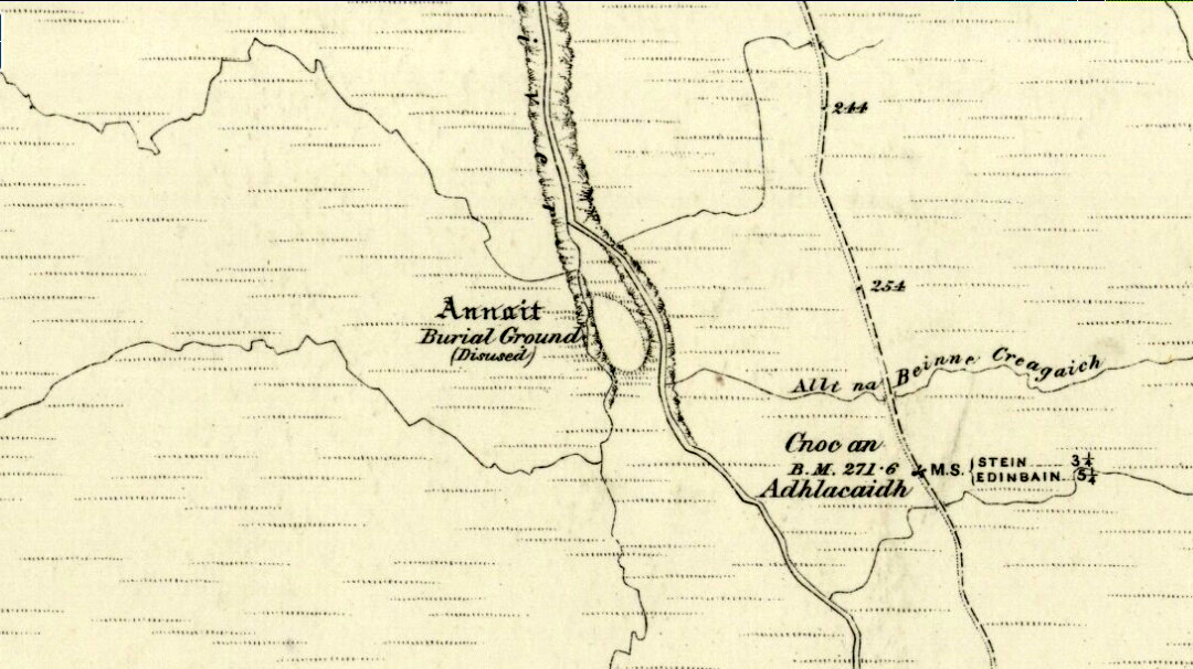
Otta Swire (1961) told how to find this place, thus: “The Waternish road turns off to the north at Fairy Bridge, whence it runs along the valley of the Bay river. On the left of the road, though at some little distance from it, where the river cleaves its way through a gorge to the sea, stands the mound which is now all that remains of the ‘Temple of Anaitis’ (so called).”
Archaeology & History
This is a curious place, full of archaeological potential if the folklore and history records are owt to go by, yet little of any substance remains to substantiate what may have been an important stone circle or other heathen site in earlier times. It seems to have been described first of all in the famous Hebridean journeys of Boswell and Johnson in the late 18th century. Amidst his insulting description of both the landscape and local people, on Friday 17th September 1773, James Boswell visited the site and told:
“The weather this day was rather better than any that we had since we came to Dunvegan. Mr M’Queen had often mentioned a curious piece of antiquity near this which he called a temple of the goddess Anaitis. Having often talked of going to see it, he and I set out after breakfast, attended by his servant, a fellow quite like a savage. I must observe here, that in Skye there seems to be much idleness; for men and boys follow you, as colts follow passengers upon a road. The usual figure of a Sky boy, is a lown with bare legs and feet, a dirty kilt, ragged coat and waistcoat, a bare head, and a stick in his hand, which, I suppose, is partly to help the lazy rogue to walk, partly to serve as a kind of a defensive weapon. We walked what is called two miles, but is probably four, from the castle, till we came to the sacred place. The country around is a black dreary moor on all sides, except to the sea-coast, towards which there is a view through a valley, and the farm of Bay shews some good land. The place itself is green ground, being well drained, by means of a deep glen on each side, in both of which there runs a rivulet with a good quantity of water, forming several cascades, which make a considerable appearance and sound. The first thing we came to was an earthen mound, or dyke, extending from the one precipice to the other. A little farther on, was a strong stone-wall, not high, but very thick, extending in the same manner. On the outside of it were the ruins of two houses, one on each side of the entry or gate to it. The wall is built all along of uncemented stones, but of so large a size as to make a very firm and durable rampart. It has been built all about the consecrated ground, except where the precipice is deep enough to form an enclosure of itself. The sacred spot contains more than two acres. There are within it the ruins of many houses, none of them large, a cairn, and many graves marked by clusters of stones. Mr M’Queen insisted that the ruin of a small building, standing east and west, was actually the temple of the goddess Anaitis, where her statue was kept, and from whence processions were made to wash it in one of the brooks. There is, it must be owned, a hollow road visible for a good way from the entrance; but Mr M’Queen, with the keen eye of an antiquary, traced it much farther than I could perceive it. There is not above a foot and a half in height of the walls now remaining; and the whole extent of the building was never, I imagine, greater than an ordinary Highland house. Mr M’Queen has collected a great deal of learning on the subject of the temple of Anaitis; and I had endeavoured, in my journal, to state such particulars as might give some idea of it, and of the surrounding scenery” —
But in all honesty it seems Mr Johnson was either too lazy to write about the place, or simply didn’t actually get there, in spite of what he alleged! But later that evening, Boswell dined with the same Mr MacQueen, who told him more of this site. In the typically pedantic tone of english supremacy (which still prevails in some idiots who visit these lands), he continued by saying:
“Mr Macqueen had laid stress on the name given to the place by the country people, Ainnit; and added, ” I knew not what to make of this piece of antiquity, till I met with the Anaitidis delubrum in Lydia, mentioned by Pausanias and the elder Pliny.” Dr. Johnson, with his usual acuteness, examined Mr Macqueen as to the meaning of the word Ainnit, in Erse, and it proved to be a water-place, or a place near water, “which,” said Mr. Macqueen, “agrees with all the descriptions of the temples of that goddess, which were situated near rivers, that there might be water to wash the statue.”
There ensued a discussion between Mr MacQueen and Samuel Johnson about the etymology of Anaitis, with one thinking it was of a goddess, and another that it represented an early christian site. To this day it is difficult to say what the word means with any certainty. In W.J. Watson’s (1993) fine work he tells us,
“Andoit, now annaid, has been already explained as a patron saint’s church, or a church that contains the relics of the founder. This is the meaning in Ireland and it is all we have to go upon. How far it is held with regard to Scotland is hard to say… They are often in places that are now, and must always have been, rather remote and out of the way. It is very rarely indeed that an Annat can be associated with any particular saint, nor have I met any traditions connected with them. But wherever there is an Annat there are traces of an ancient chapel or cemetery, or both; very often, too, the Annat adjoins a fine well or stream…”
The great Skye historian and folklorist Otta Swire (1961) also wrote about this mysterious site, mainly echoing what’s said above, but also adding:
“This name of Annait or Annat is found all over Scotland. It has been interpreted as meaning the ‘Water-place’ from Celtic ‘An’ = water, because many are near water. Others suggest ‘Ann’ = a circle (Celtic) and claim that most Annats are near standing stones. The most-favoured derivation seems to be from Ann, the Irish mother of the Gods, and those who hold this view claim that the Annats are always near a revered spot, where either a mother-church or the cell of a patron saint once stood. Probably Annat does, in fact, come from an older, pre-Celtic tongue, and belongs to an older people whose ancient worship it may well commemorate. The curious shape of the Waternish Temple of Anaitis and its survival make it seem likely that it was something of importance in its day, built with more than usual care and skill. Perhaps the Temple tradition is correct – but whose, if so, and to what gods? One cannot help wondering if cats played any part in its ritual, and if so, if any faint memory remains, for the nickname of the people of this wing was ‘Na Caits’ = The Cats, and not far off, by one of the tributary burns on the right of the roadway, there stands a small cairn, crowned by a long, sharp stone somewhat resembling a huge claw. This is the ‘Cats’ Cairn’.”
The Cats’ Cairn (NG271526) is said to mark the grave of a young boy from the 18th century, who was buried where he died and its story is told elsewhere on TNA. Another example of the Annait place-name can be found elsewhere on Skye at the megalithic site, Clach na h’annait.
References:
Boswell, James, The Journal of a Tour to the Hebrides with Samuel Johnson, National Illustrated Library: London 1899.
Swire, Otta F., Skye: The Island and its Legends, Blackie: Glasgow 1961.
Watson, W.J., The History of the Celtic Place-Names of Scotland, Birlinn: Edinburgh 1993.
This curious rounded boulder sitting outside the parish church was described by Alexander Polson in his survey of witch-lore. He told us that “when the old church was being built, the devil, as a mason out of work, came here and was employed.” But it wasn’t long before a local christian discovered his disguise and, uttering some magickal biblical words, the devil became furious.
“Immediately he heard this there was a clap of thunder and the fiend flew away to the Isle of May,” about five miles away to the south. “Here in his anger he seized a huge rock and hurled it at the church. It fell quite near, did no harm, and a part of it lay at the church’s door, with the mark of the devil’s thumb on it.”
On the north end of the Isle of May are the Altar Stanes (NT 652 997), thought to have been where the devil stood (close to the holy well of St. Andrew [NT 652 994]) and threw this stone at Crail several miles north. In pre-christian mythic terms, north is the direction or airt of greatest symbolic darkness. A variation on the creation myth for this stone tells that when it was thrown from the island, one half of it split off and it fell by the coast in Balcombie, Fife.
References:
Polson, Alexander, Scottish Witchcraft Lore, W. Alexander: Inverness 1932.
Unless you’ve got your own boat, forget it! This one’s miles out on the isolated uninhabited island of Fladda-chuain about 5 miles off the northwest tip from Duntulm, Trotternish. I wouldn’t mind a coupla weeks alone on the isle though – if anyone can get me there!
Archaeology & History
The little rocky island itself was allegedly another of the many visiting places of St. Columba in his many ventures to sell his religion to the peasants and displace the druids, who were alleged to practice pre-christian rites here and deemed it as sacred. St. Columba’s chapel on this island was built to displace the heathen traditions.
Folklore
In Otta Swire’s (1961) excellent work on the folklore and history of the Isle of Skye, she wrote:
“In Duntulm Bay lies Tulm Island and beyond it, in clear weather, Fladdachuan, Fladda of the Ocean, can be seen. In olden times this was a sacred spot, held by many to be Tir-nan-Og, the Isle of Perpetual Youth, which lay in the west; here it is always summer and the sun never sets. The puffins recognized its sacred nature and never began any venture until they had circled the island three times sunwise; this they did also on arriving in Skye and before leaving it. It was held by some to be the reason why in Skye people used to turn three times sunwise before starting a new enterprise. The Druids held it in veneration and St. Columba caused a chapel to be built there. On its altar lay a black stone which some say was the original altar stone of the Druids and which was known as the Weeping Stone because it was always wet. Until fairly recently fishermen used to land on the island and pour three handfuls of seawater on the stone to procure favourable winds or to stop bad floods. The Weeping Stone no longer exists, or at least is no longer to be found where the altar once stood.”
I can’t find anything more about this place. Does anyone know owt more about it?
References:
Swire, Otta F., Skye: The Island and its Legends, Blackie & Son: Glasgow 1961.
Found to the southwest edge of Hildenley Wood, on the west side of the track between Malton and Coneythorpe Road, the waters from the initial source of the well runs into a small well-house, and from here Nature’s blood runs into a small pool. The first reference I’ve found of the place is in T. Whellan’s (1859) huge survey, where he said,
“There is on the verge of Easthorpe Wood a copious and pure spring of water known by the name of Holy Well, which tradition affirms to have been much resorted to by the monks of Kirkham Abbey…and even to this day healing virtues are attributed to it.”
In Whelan & Taylor’s (1989) survey of the site, they noted the existence of another well a short distance away, but did “not know of any sacred associations connected with this site, but its proximity to the Holy Well may suggest the recognition of this area as a sacred spot.”
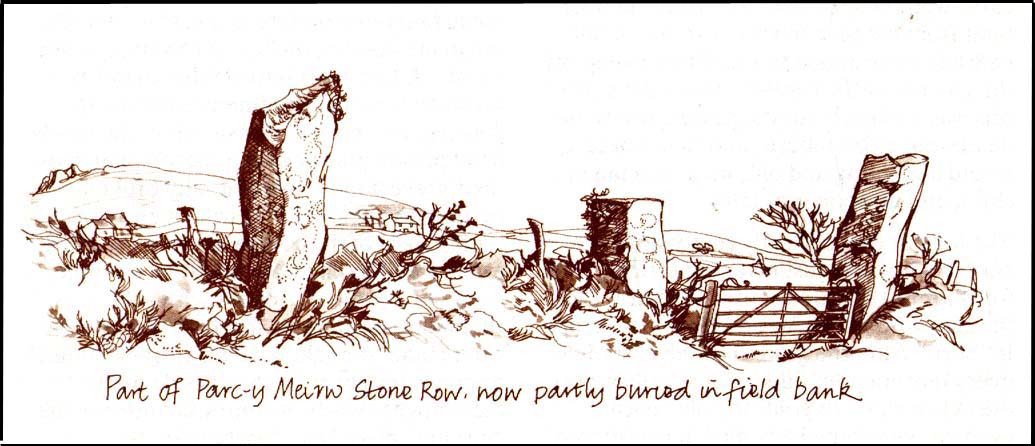
This is an impressive and well-known megalithic stone row, found just 4-5 miles inland from the coastal town of Fishguard. The drawing here is used courtesy of Elizabeth Haines, landscape artist, and gives a fine representation of the site as I’m sure you’d agree! Consisting of at least eight standing stones — four still upright and four laid down — aligning northwest to southeast, the tallest stone stands at the southerly end measuring 11 feet tall. The stone row is found in a region rich in prehistoric remains. Aubrey Burl (1993) said of the place:
“Four of the eight stones in this unusual row still stand, trapped in a field-wall, tow of them now gateposts. Thom suggested that the line, 131ft (40m) long, was laid out downhill towards the WNW and the minor northern moonset just north of Mount Leinster ninety-one miles away across the Irish Sea.”
Quite a distance! And perhaps because of this, Burl thought that the nature of this line of stones was more archaeological than astronomical, with its focal point being more likely up the slope to the ESE instead.
Folklore
There was once an adjacent chambered tomb here which, when it was “destroyed for a house in 1844 brought the owner no luck” (Thom, Thom & Burl 1990) – which is damn good to hear! There was a piece of folklore mentioned by E.L. Barnwell (1868) and other writers that the fields here marked the fall of three Welsh princes in the Battle of Mynydd Carn in 1084. In Roger Worsley’s (1988) fine tour of Pembrokeshire’s historical sites, he tells how these megaliths in the “field of the dead” are also haunted, saying:
“A local tale tells of Ladi Wen, a ghostly White Lady wandering about the fields at night, and who will kill anyone who ventures near; it was enough to keep villagers away from the site well into this century, though the stone row is over five thousand years old.”
References:
Barber, Chris & Williams, John Godfrey, The Ancient Stones of Wales, Blorenge: Abergavenny 1989.
Barnwell, E.L., “Alignments in Wales,” in Archaeologia Cambrensis, volume 14, 1868.
Burl, Aubrey, From Carnac to Callanish, Yale University Press 1993.
Thom, Alexander, Thom, A.S. & Burl, Aubrey, Stone Rows and Standing Stones, BAR 560: Oxford 1990.
Worsley, Roger, The Pembrokeshire Explorer, CCP: Abercastle 1988.
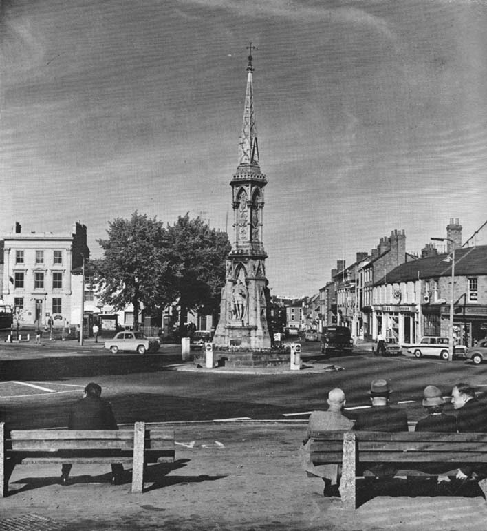
The original stone monolith that stood here has long since been destroyed (by christians arguing amongst themselves) and the ornate edifice that we see today was erected in 1859 to commemorate the marriage of Queen Victoria’s eldest daughter, Victoria Adelaide Mary Louisa, to Friedrich Wilhelm of Prussia. Standing more than 52 feet tall, it is of a neo-Gothic design and is one of the tallest crosses in the country. Originally there were going to be six carved statues cut into the niches of the cross, but this was later reduced to three.
First mentioned in place-name records from 1478, the original stone cross was itself very prominent, rising some 20 feet tall and sitting upon a square base of eight steps. It was described by John Leland in his Itinerary when he visited the town sometime between 1535 and 1545, who said:
“At the west part of the street…is a large area, having a goodly cross with many degrees (steps) about it. In this area is kept every Thursday a very celebrated market.”
The old cross was also a site where public notices and proclamations were dispensed to local people and seems to have been an old meeting place. Whether it had a prehistoric predecessor isn’t known.
Folklore
The nursery rhyme we’ve all recited when we were kids and growing-up, has much of its origins around this ornate edifice and in the 20th century was thought to have its origins in pre-christian practices hereby, but this is questionable. The rhyme, to those who don’t know it, goes:
Ride a cock-horse to Banbury Cross,
To see a fine lady upon a white horse,
With rings on her fingers and bells on her toes,
She shall have music wherever she goes.
As Kirsten Ayles (1973) told:
“This rhyme was first recorded in 1784, but it probably originated much earlier. The Banbury Cross mentioned was destroyed at the turn of the 16th century by the Puritan inhabitants of Banbury. It has been suggested that “bells on her toes” points to the fifteenth century, when a bell was worn on the long tapering shoe of each shoe. It has (also) been thought that the “fine lady” was Queen Elizabeth I, or Lady Godiva.”
Another option identifying the “fine lady” in the rhyme is perhaps a member of the Fiennes family, ancestors of Lord Saye and Sele who owns nearby Broughton Castle.
References:
Ayles, Kirsten, “A Short History of Nursery Rhymes,” in This England, 6:3, Autumn 1973.
Gelling, Margaret, The Place-Names of Oxfordshire (2 volumes), Cambridge University Press 1954.
Vallance, Aymer, Old Crosses and Lychgates, Batsford: London 1920.
Acknowledgements:
To Ronald Goodearl, for use of his 1973 photograph of the Banbury Cross.
From the village of Midgley, high above the A646 Halifax-to-Todmorden road, travel west along the moorland road until you reach the sharp-ish bend in the road, with steep wooded waterfall to your left and the track up to the disused quarry of Foster Clough. Go up the Foster Clough track for 100 yards and, when you reach the gate in front of you, go over it but follow the line of the straight walling uphill by the stream-side (instead of following the path up the quarries) all the way to the top. Here you’ll see the boundary stone of Churn Milk Joan.
Archaeology & History
The present large standing stone you see before you isn’t prehistoric. However, the small broken piece on the ground by its side may have been its prehistoric predecessor; and there is certainly something of an archaic nature here — albeit a contentious one — as we find old cup-markings cut into its eastern face.
Two ‘cup-marks’ on eastern face
The upright is roughly squared and faces the cardinal points. It was described in Mr Heginbottom’s (1977) unpublished survey on Calderdale rock art, where he described there being a few cup-markings inscribed on its east- and south-facing edges, some of which may be prehistoric — though they would obviously have had to have been carved upon the upright stone when it still lay earth-fast. However, we must posit the the notion (unless some of you have better ideas) that the tradition of etching cup-marks onto rocks was still occurring in this part of Yorkshire until the late Middle Ages, as this stone was, as we know from boundary records, only placed upright to mark the meeting of the three boundaries of Wadsworth, Hebden Royd and Sowerby.
Churn Milk Joan’s other name, Saville’s Low, originates from the great Saville family who owned great tracts of land across the region in the fourteenth century, possibly when the Churn Milk Joan we see today was created. The word “lowe” may derive from the old word meaning, “moot or gathering place,” which this great stone probably served as due to its siting at the junction of the three townships.*
Folklore
In modern times the stone has become a focus for a number of local pagans and New Agers who visit and ‘use’ the site in their respective ways at certain times of the day, albeit estranged (ego-bound) from the original mythic nature of the site.
The name of the stone comes from an old legend about a milk-maid named Joan who, whilst carrying milk across the moors between Luddenden and Pecket Well, got caught in a blizzard and froze to death. When her body was found many days later, the stone we see here today was erected to commemorate the spot where she died. Although such a scenario is quite likely on these hills, as Andy Roberts (1992) said,
“Considering the sheer amount of sites with similar legends this explanation is unlikely to be true and we should looker deeper for the meaning behind Churn Milk Joan, to be found in its positioning in the landscape and ourindividual feelings about it.” [see profiles for the Two Lads and the Lad o’ Crow Hill sites)
The monolith’s other title, Churnmilk Peg, is the name given to an old hag who is said to be the guardian of nut thickets. How this female sprite came to find her abode upon these high hills is somewhat of an enigma, but it was first stated as such in an article by Andy Roberts (1989) in “Northern Earth Mysteries” magazine. E.M. Wright (1913) noted this supernatural creature in her work on folk dialect, describing it as a West Yorkshire elemental who, along with another one known as Melsh Dick:
“are wood-demons supposed to protect soft, unripe nuts from being gathered by naughty children, the former being wont to beguile her leisure by smoking a pipe.”
Another legend of the stone tells how it is said to spin round three times on New Year’s Eve when it hears the sound of the midnight bells at St. Michael’s church (St. Michael was a dragon-slayer) at Mytholmroyd in the valley below. Another piece of folklore tells that coins used to be left in a small hollow at the very top of the stone which, according to Haslem (1981), was “a gift to the spirit world, to bring luck” – a common folk motif. It may equally originate from the custom of it as a plague stone. This tradition of leaving coins atop of the stone is still perpetuated by some local folk.
Mr Haslem also made some interesting remarks about the nature of Churn Milk Joan standing as a boundary stone, representing something which stands not just as a physical boundary, but as a boundary point between this and the Other- or spirit world. In folklore, streams and rivers commonly carry this theme. But here on Midgley Moor, as a standing stone at the junction of three boundaries, we may be looking at the place as an omphalos: a centre point from which the manifold worlds unfold. (see Almscliffe Crags, the Ashlar Chair and the Hitching Stone)
The other motif here, of milk and snow [both white], have been speculated to represent power of the sun at midwinter, and geomantically we find the position of the stone in the landscape exemplifying this: it stands midway in the moorland scenery facing south, the direction of solar power, yet is bounded as an equinox marker from east and west. The winter tales it has nestled around it are merely complementary occult augurs of its more wholesome elements at this point in the hills.
There is however, another much more potent element that has not been conveyed about the site and its folklore—and one which has more authenticity and primary animistic quality. Regardless of ‘Joan’ or ‘Peg’ being the elemental preserved in the landscape title, the ‘churning’ in its name and the ‘spinning’ of the stone in myth at the end of one year and the start of the next at New Year, are folk memories of traditional creation myths that speak of the cyclical seasons endlessly perpetuated year after year after year, in what Mircea Eliade (1954) called the ‘myth of the eternal return.’ As season follows season in the folk myths of our ancestors, everything related to the natural world: a world inhabited (as it still is) by feelings and intuitions learned from an endless daily encounter, outdoors, with the streams, hills, gales, snow and fires. Their entire cosmology, as with aboriginal people the world over, saw the cycles of the year as integral parts of their daily lives. Here, at Churn Milk Joan with its central landscape position along an ancient boundary, the churning and turning of the year was commemorated and mythologized year after year after year; with maybe even the Milky Way being part of the ‘milk’ in its title, from which, in the shamanistic worlds that were integral to earlier society, the gods themselves emerged and came down to Earth.
References:
Bennett, Paul, The Old Stones of Elmet, Capall Bann: Milverton 2001.
Eliade, Mircea, The Myth of the Eternal Return, Bollingen 1954.
Haslem, Michael, “Churn Milk Joan: A Boundary Stone on Midgley Moor,” in Wood and Water, 1:8, 1980.
Heginbottom, J.A., “The Prehistoric Rock Art of Upper Calderdale and the Surrounding Area,” Yorkshire Archaeology Society 1977.
Ogden, J.H., “A Moorland Township: Wadsworth in Ancient Times,” Proceedings of the Halifax Antiquarian Society, 1904.
Robert, Andy, “Our Last Meeting,” in NEM 37, 1989.
Robert, Andy, Ghosts and Legends of Yorkshire, Jarrold: Sheffield 1992.
Wright, Elizabeth Mary, Rustic Speech and Folk-Lore, Oxford University Press 1913.
* The great stone at the cente of the Great Skirtful of Stones, Burley Moor, which previously stood at the centre of the Grubstones Circle, was just such a moot stone. Upon it is carved the words “This is Rumble’s Lawe”.
Cup-and-Ring Stone: OS Grid Reference – NM 027 487
Also Known as:
Kettle Stone
Ringing Stone
Singing Stone
Archaeology & History
This is a fascinating large coastal boulder with around 53 cup-markings on it — but whether these are all man-made is a matter of debate. Some of them may be natural. However some of the cups have lines and faint rings around them, showing that at least they’re man-made; and also in one of the large cups are placed small pebbles, similar in form to the well-known Butter Rolls, or bullaun stone at Feaghna, Ireland.
Folklore
This large boulder (suggested to have been dragged and dropped here from the Isle of Rhum in an earlier Ice Age) is known in the modern tongue as the ‘Ringing Stone’ because, allegedly, if you knock the surface hard with another stone it supposedly chimes with a metallic noise. As one of the links below shows, however, it doesn’t necessarily do the trick! Local folklore tells that if the stone is ever destroyed, or falls off its present platform of smaller stones, Tiree itself will sink beneath the waves. Other lore tells that this great rock is hollow; and another that it contains a great treasure. According to Otta Swire (1964),
“Some believe this to be a treasure of gold, others claim it to be the resting place of the Feinn who there await the call to rescue Scotland.”
References:
Royal Commission on the Ancient & Historical Monuments of Scotland, Argyll – volume 3: Mull, Tiree, Coll and Northern Argyll, HMSO: Edinburgh 1980.
Swire, Otta F., Inner Hebrides and their Legends, Collins: London 1964.