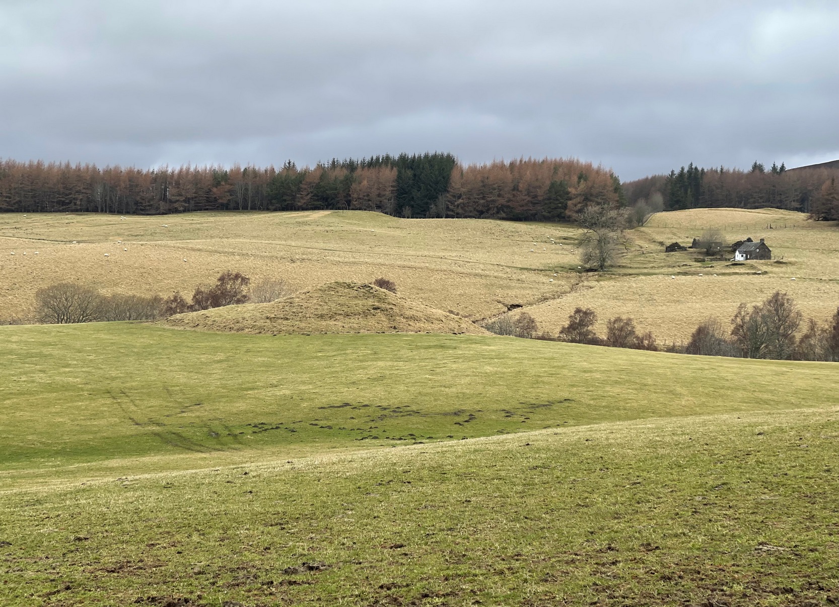
Along the B8079 road in Blair Atholl village, take the minor road signposted to the Bridge of Tilt. After half-a-mile, where the road splits, keep to the right and head further uphill and, where the almost-track-like road splits again another quarter mile up, bear to the right again and just keep going uphill for nearly two miles until your reach the large car-park on the left. Park here and then take the dirt-track to the farm (truly friendly helpful folk) where, in the field to the rear of the buildings, a large unmissable mound rises up!
Archaeology & History
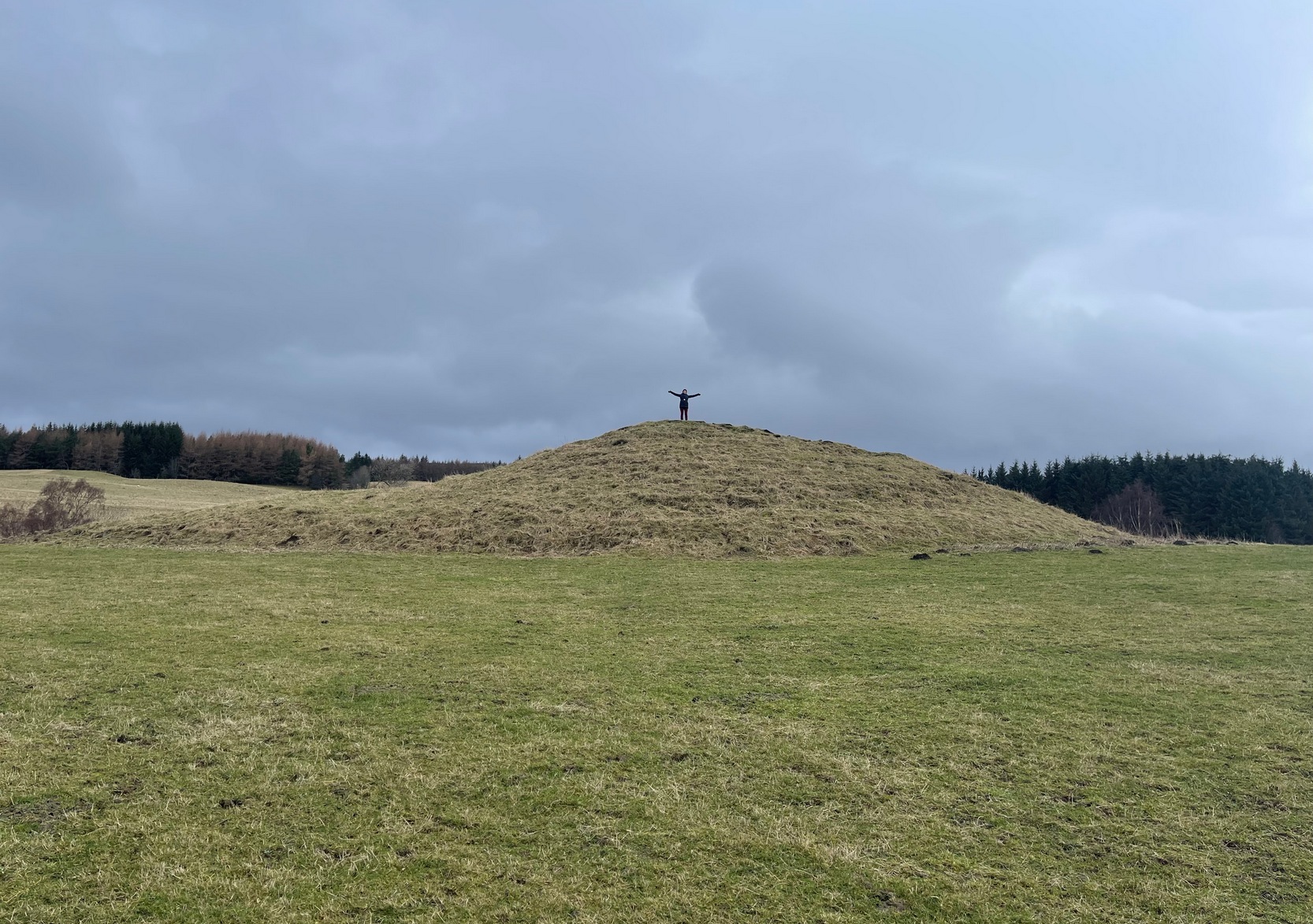
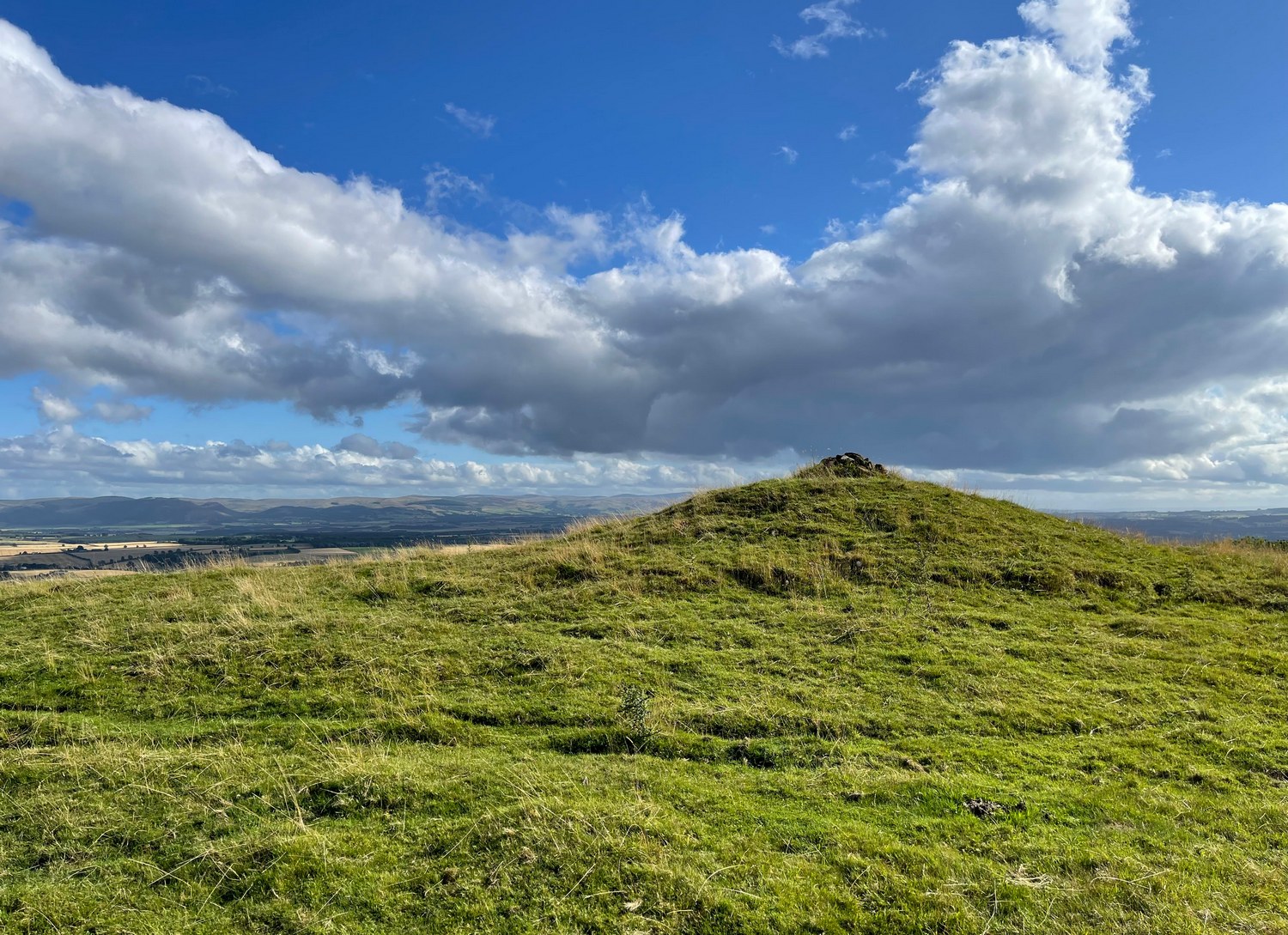
This is a bit of a beauty! Hiding away on the southern edges of the Cairngorms we find this huge archetypal burial mound, 35 yards across and all but covered nowadays in deep layers of soil. But it looks good. When you walk onto its crown, about twelve feet up, you see and feel beneath you the scattered mass of small rocks and stones that comprise the monument as a whole, from top to bottom. On its south-western side, the cairn is lower and elongated: this is due, on the whole, to where field clearance stones were pushed up against the monument many decades ago, making that side of it look bigger than it originally was.
Naomi on top for size!Monzie cairn, looking W
Curiously perhaps, no archaeological attention of any worth has been give to the site apart from the usual estimates of its size and a guesstimate of it being neolithic or Bronze Age in nature (an easy thing to suggest). On top, just beneath the grasses, is what may be the section of a small cist, but this may just be a fortuituous formation. Excavation is required! It’s one of a small number of old cairns and tombs in this locale, but this seems to be the biggest — unless, of course, the lost but legendary Carn Deshal, less than a mile to the south, stood larger…
Acknowledgements: To my awesome Naomi – for getting us up here.
Cup-Marked Stone (lost): OS Grid Reference – NU 2299 2989
Archaeology & History
Tait’s 1971 sketch of the carving
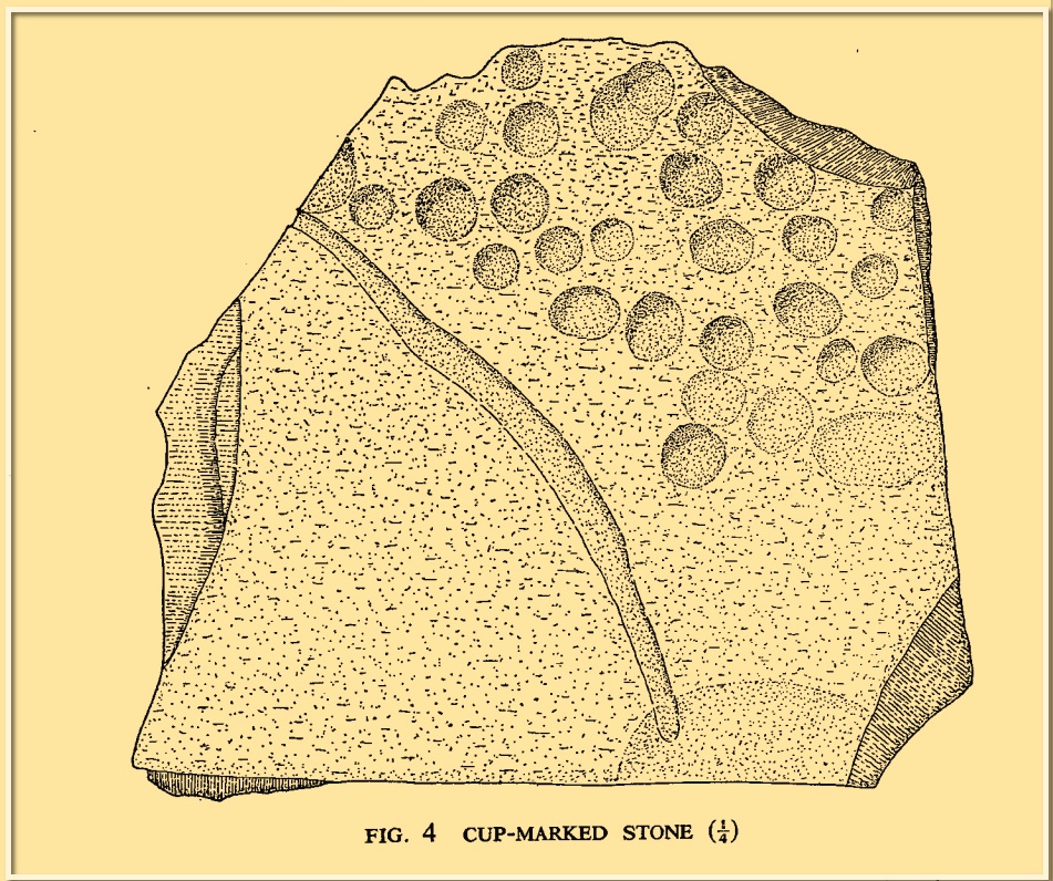
When the Beadnell Caravan Park was being constructed in 1970, in cutting into the Earth the workmen destroyed a couple of prehistoric tombs—but not before one of them (the northernmost one of the two) was thankfully excavated. It was looked at by John Tait (1971), who described the covering cairn as measuring “nineteen feet in diameter and four feet high”. Beneath it, within a cist that had been modified at two very different periods in time, were a large number of human remains that had been deposited over equally extended periods, suggesting it was a place of considerable importance to either one family lineage or the tribal lineage (unless it was just a dumping spot for any old Tom, Dick and Harry!). Outside of the cist itself, but within the rocky mass of the cairn, this cup-marked stone was found (illustrated). It had already been moved by the workmen before Tait came to excavate it, so he was unable to ascertain its precise position in the tomb. Carved into a piece of sandstone were a number of odd-sized cup-marks, smaller than usual. Tait wrote:
“It measures 38cm by 36cm and bears 29 small cup-marks and one slightly sinuous duct leading into what may be part of an earlier and larger cup. It also seems probable that additional cups were added in antiquity, since some are distinctly more shallow than others and, in one instance, two cups impinge upon one another. The stone had been broken in antiquity and may have come from a larger inscribed slab, as is perhaps the case with some other “portable” stones of burials or cairns and other monuments of the second this nature.”
It is thought that the carving was laid back in the ground whence it was found.
References:
Beckensall, Stan, Prehistoric Rock Motifs of Northumberland – volume 1, Abbey Press: Hexham 1991.
Beckensall, Stan, Prehistoric Rock Art in Northumberland, Tempus: Stroud 2001.
Tumulus (destroyed): OS Grid Reference – SX 0309 5227
Archaeology & History
More than two hundred years ago, an impressive prehistoric burial mound lived in an area that used to be known as Gwallon Down, not far from the impressive Long Stone monolith, about half-a-mile west of Charlestown on the southern edges of St. Austell, but it was completely destroyed in 1801. Thankfully there was a lengthy account made of the site in John Whitaker’s (1804) huge work, but there seems to be little else known of it. He told us:
“In the middle of that extended waste, the downs of St. Austle, was, what was called One Barrow. This waste, in 1801, was resolved to be enclosed, and the barrow was obliged to be levelled. In this operation, the single workman came near the centre, and there found a variety of stones, all slates, ranged erect in an enclosure nearly square. The stones were about one foot-and-a-half in height, apparently fixed in the ground before the formation of the barrow. The stones were all undressed, but had little stones carefully placed in the crevices at the joints of the large, in order to preclude all communication between the rubbish without and the contents within. On the even heads of these stones was laid a square freestone, which had evidently been hewn into this form, which seemed to rest with its extremities on the edges of the others, and was about eighteen or twenty inches in diameter. The summit of the barrow rose about eight or ten feet above all. In the enclosure, the leveller found a dust, remarkably fine, and seemingly inclining to clay. On the surface it was brown, about the middle downwards it took a dark chestnut colour, and at the bottom it approached towards a black. On stirring it up, a multitude of bones appeared, different in the sizes, but none exceeding six or seven inches in length. Among them were some pieces about the largeness of a half-crown, which, from their concave form, convinced him they were parts of a skull. The whole mass of bones and ashes might (he thought) be about one gallon in quantity. On touching the bones, they instantly crumbled into dust, and took the same colour with the same fineness as the dust in which they were found. They were exceedingly white when they were first discovered, but remarkably brittle; the effect assuredly of their calcination in a fire, antecedent to their burial. Much in fineness and in colour with these ashes, appeared several veins of irregular earth on the outside of the enclosure; which, from their position without, yet adjoining, and from the space occupied by them there, he conjectured to have been bodies laid promiscuously upon the funeral pile, but which I conjecture to have been only the ashes adhering to the ground, and not possible to be separated from it, for a burial with the rest within the enclosure. They had nothing of sand in them, but seemed inclining to clay, and even more so (from the adhering soil probably) than the dust of the enclosure. And, as the workman was fully convinced of what every one else must acknowledge, that the ashes and the bones of the enclosure had once belonged to a human body, he very properly took up the whole with care, placed the stones nearly in their original posture within an hedge contiguous, then in building, placed also the bones with the ashes within their original enclosure there, and even placed the covering-stone over both.”
One wonders where precisely the hedgerow happened to be where the stones were placed “nearly in their original posture”, and if this reconstruction was ever recovered.
The site was subsequently mentioned in Polwhele’s (1816) massive survey, reiterating Whitaker’s description, simply telling how:
“With respect to the monumental remains in the neighbourhood of St Austel, a very ingenious correspondent says in one of the mounds of earth on our downs which was lately levelled a kind of urn was discovered which evidently contained human ashes many of the bones were entire but appear to have been calcined I am well acquainted with the man who dug this up.”
References:
Borlase, William Copeland, Nænia Cornubiæ, Longmans Green Reader: Truro 1872.
Hammond, Joseph, A Cornish Parish: Being an Account of St. Austell, Skeffington & Sons: London 1897.
Polwhele, Richard, The History of Cornwall – volume 2, Law & Whittaker: Truro 1816.
Whitaker, John, The Ancient Cathedral of Cornwall – volume 2, John Stockdale: London 1804.
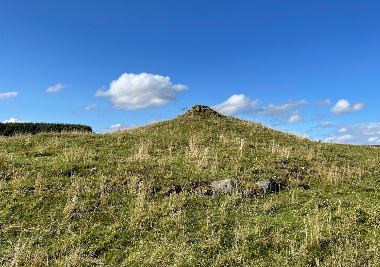
Make a day out for this one! You could, of course, go barely half-a-mile straight up the hill (southwest) from Ossian’s Stone in the Sma’ Glen below – but it’s steep as fuck and I know that most of you wouldn’t do it. So, park-up and take the gradual 3 mile walk into the mountains. Coming via Crieff, along the A85 road east, turn left up the A822 Dunkeld road at Gilmerton. 2½ miles on, you reach the Foulford golf course on the right-hand side of the road, whilst directly across the road a dirt-track leads you into the fields, past the large Foulford cup-and-ring stone. Keep along this track, bearing right just before Connochan Lodge and follow this dirt-track uphill on and on for another 2 miles where you’ll eventually see the cairn-peak in the distance. Another shallow track leads uphill after about 2 miles: we walked up to where the ground levels out, walked across the dodgy swamp-land and up again to the tomb. It’s well worth it!
Archaeology & History
Visible for many miles round here from the surrounding hills, this somewhat mutilated giant cairn, highlighted on the earliest Ordnance Survey map of the area in 1867, hasn’t fared well in archaeology tomes. Apart from a passing note in Margaret Stewart’s (1966) summary article on prehistoric remains in central Perthshire—where she erroneously told it to be 400 feet lower down that it actually is—almost nothing has been said of this place. Most odd.
Cairn spoil, looking SENew cairn atop of the old
Despite it being ransacked over the centuries, it was obviously of some considerable size in its early days. Today, surmounting it, is a very large walker’s cairn which, no doubt, has accrued some of its own foundations from the prehistoric tomb on which it sits. To the side of this recent cairn, another one is growing, thanks to stones brought from near and not-too-far. But the original creation can still be seen in outline and mass all around. Indeed, as you walk all round the modern cairn, you’re walking over much of the early collapsed stonework sleeping gently beneath the moorland vegetation, and once you walk away and below the cairn mass itself, looking back up at it you’ll notice the very ancient raised plinth of stone on which our modern one now lives.
Low walling on NW side
Its amorphous shape is somewhat amoeboid, measuring more than 22 yards across east-west, by 15 yards north-south, with a curious arc of low walling, very old indeed, on its northwestern side. Whether this walling outlines the original edge of the tomb, only an excavation will tell. The most notable remaining mass of ancient cairn material reaches out on its south-east to eastern edges, where some of it is beginning to fall away down the edge of the mountain slope.
Folklore
Local tradition assigns this cairn to be where the bones of the great hero-figure Ossian was removed to, when they were disturbed by the unruly mob of General Wade and his cohorts in the middle of the 18th century. Notes of the event were written at the time by one of Wade’s mob, a Captain Edward Burt, who told,
“the Highlanders, they assembled from distant parts, and having formed themselves into a body, they carefully gathered up the relics, and marched with them, in solemn procession, to a new place of burial, and there discharged their fire-arms over the grave, as supposing the deceased had been a military officer.”
This was essential, said Burt, as
Site shown on 1867 mapNew cairn on old, looking W
“they (the Highlanders) firmly believe that if a dead body should be known to lie above ground, or be disinterred by malice, or the accidents of torrents of water, &c. and care was not immediately taken to perform to it the proper rites, then there would arise such storms and tempests as would destroy their corn, blow away their huts, and all sorts of other mis-fortunes would follow till that duty was performed. You may here recollect what I told you so long ago, of the great regard the Highlanders have for the remains of their dead…”
Oral tradition tells us that this cairn, high above Ossian’s Stone, is where the rites occurred. It makes sense too.
References:
Finlayson, Andrew, The Stones of Strathearn, One Tree Island: Comrie 2010.
Acknowledgements:Huge thanks for use of the Ordnance Survey map in this site profile, reproduced with the kind permission of the National Library of Scotland.
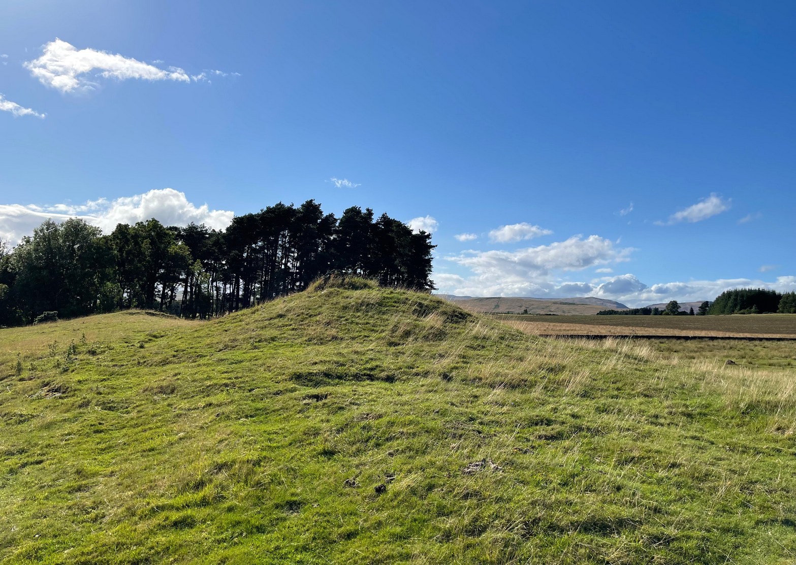
You need to hit the village of Fowlis Wester, which is easiest to approach from both east and west along the A85, between Crieff and Perth: nearly 3 miles east of Gilmerton and about 6½ mile west of Methven. Keep your eyes peeled and take the road up (north) where the large rounded tree-covered tumulus stands and up to the village. Go through the village and uphill for literally ½ a mile (veering sharp left at a junction) where a gate on your right leads into the fields. (a large parking spot is 300 yards further uphill) Walk ¼-mile east and through the other side of the small woodland, over the fence, you’ll see the mound of a typical tumulus. That’s it!
Archaeology & History
If you’re going to visit the megalithic remains of Fowlis Wester ¾-miles to the west, the antiquarians amongst you might as well give this old burial mound your attention too. It’s not grandiose by any means, but its position in the landscape is quite superb. It’s built upon a long geological promontory with extensive views that reach from south-east to south to south-west for many miles into the distance with the Ochils framing the majority of the southern horizon, but also with the notable pap of the West Lomond hill 20 miles to the south-east mimicking the shape of the tomb itself. It was obviously built here with the extended landscape having some ancestral importance. Visit it and see for yourself!
Despite being a notable mound, this tumulus-cum-cairn only seems to have been written about for the first time as recently as 1998, when archaeologist Ian Armit visited the site. Roughly circular in form, it’s about 12 yards across and more than six feet in height. A small pile of stones crowns the very top, placed here in much more recent times. At ground level on its northern side, an arc of low lying stones define the edge of the tomb. The stones probably continue all the way round the entire structure, but it’s overgrown by centuries of soil and vegetation and we lose sight of it as we walk round. When Mr Armit (1998) wrote about the site, he and colleague wrote:
Seat Knowe, looking NWSeat Knowe, looking north
“A grassed-over stony cairn lies on the highest point of Seat Knowe, a ridge commanding extensive views to the south. The cairn has a diameter of c.10m and is up to 2m high. A modern cairn occupies it summit. The low turf foundations of a rectilinear structure, some 6 x 8m, occupy its south flank, and thee are extensive cultivation and field system remains in the vicinity.”
Check it out! You won’t be disappointed.
Folklore
An interesting piece of relatively recent folklore about Seat Knowe, described in the Perthshire Name Book around 1862, told that,
“One of the Earls of Strathearn, desirous of having a church in the vicinity of his Castle, stood on an eminence, on which he had a summer seat, and resolved to erect it where the sun first shone, which was on the spot where it now stands.”
References:
Armit, Ian & Hall, M., “Seat Knowe (Fowlis Wester parish): Cairn,” in Discovery & Excavation Scotland, 1998.
Cup-Marked Stones (lost): OS Grid Reference – SE 9657 8840
Archaeology & History
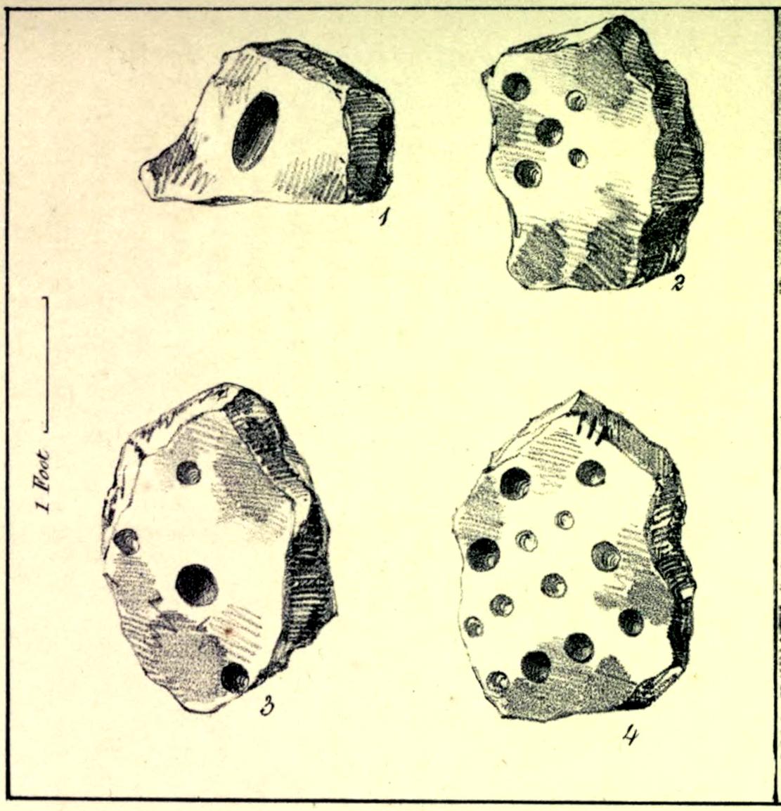
In the autumn of 1848, antiquarian John Tissiman (1850) and his associates took to uncovering two burial mounds amidst a large cluster of them on the eastern edge of West Ayton Moor. This one at Way Hagg was quite a big fella, measuring 36 yards across. When they cut into its northern edge towards the centre, 8-10 feet in, they came across an upright stone, nearly two feet high, on which five cup-marks had been cut. (see sketch, no.2) Slightly beyond this were three other stones (in sketch, nos.1, 3 & 4), each with cup-marks on them, beneath which was a tall urn. Whether or not the carvings had been deliberately positioned to cover the urn, we do not know. Nonetheless, we can be reasonably assured that these petroglyphs had some mythic association with death when they were placed here.
Tissiman gave us the following detailed measurements of the respective carvings:
“1: Nearly even surface. Length, from 16 to 18 inches; breadth, 10 to 20 ditto; depth, 8 to 9 ditto; with large oval hole cut in the centre, 7½ inches long, 4 inches broad, and 3½ inches in depth. On the opposite side are three holes, from 2 to 3 inches in diameter, and from 1 inch to 1½ deep. 2: Uneven surface. Length, 23 inches; breadth, 14 inches; depth, 13 inches; with five holes, from l½ to 3½ inches in diameter, and 1 to 1½ inches in depth. 3: Uneven surface. Length, 33 inches; breadth, 22 inches; depth, 10 inches, with four holes, the largest being 4½ inches in diameter and 3 inches deep; the others, from 1½ inches to 2 inches in diameter, and 1 to 1½ inches deep. 4: Uneven surface. Length, 27 inches; breadth, 23½ inches; depth, 10 inches, with 13 holes, from 1½ inches to 5 inches in diameter, and ¾ of an inch to 3 inches in depth; also three lines at the end of the stone.”
The carvings were included in Brown & Chappell’s (2005) fine survey, but they weren’t able to find out what happened to them after Tissiman’s excavation. They remain lost. If anyone has any information as to where they might be, please let us know.
References:
Brown, Paul & Chappell, Graeme, Prehistoric Rock Art in the North York Moors, Tempus: Stroud 2005.
Tissiman, John, “Report on Excavations in Barrows, in Yorkshire,” in Journal British Archaeological Association, April 1850.
Acknowledgements:Huge thanks for use of the Ordnance Survey map in this site profile, reproduced with the kind permission of the National Library of Scotland.
Round Barrows (destroyed): OS Grid Reference – NZ 692 214
Archaeology & History
Tumuli shown on 1920 map
On top of the large plateau that is Warsett Hill, on the southwest side of the old trig-point, could once be seen a cluster of at least seven burial mounds or tumuli. The mounds are shown on the first OS-map of the area, but merely as mounds. It wasn’t until there’d been a subsequent investigation here by local historian J.C. Atkinson in the 19th century that they were highlighted on the 1920 map as “Tumuli.” Sadly, since then, they’ve all been destroyed.
Very brief notes were written on six out of the seven tombs here by William Hornsby (1917), with only one of them receiving any real attention. “Of the other six,” Crawford (1980) wrote,
“there is very little information; all were excavated by Atkinson prior to 1893, but his excavations revealed no finds and he stated that all of the mounds had been previously disturbed. They were later dug by Hornsby, who stated that although he found no sepulchral deposits, all the mounds contained flints.”
In medieval times this became a beacon site, where bonfires were lit. I can find no further information about this. (NB: This site should not to be confused with another Warsett Hill that exists two miles southeast of here above Skinningrove.)
References:
Crawford, G.M., Bronze Age Burial Mounds in Cleveland, Cleveland County Council 1980.
Hornsby, William & Stanton, R., “British Barrows near Brotton,” in Yorkshire Archaeological Journal, volume 24, 1917.
Acknowledgements:Huge thanks for use of the Ordnance Survey map in this site profile, reproduced with the kind permission of the National Library of Scotland.
Tumulus (destroyed): OS Grid Reference – SE 234 336
Archaeology & History
Today, Hough Hill has almost completely given way to modern housing; but in bygone centuries, this hilltop once housed a prehistoric burial mound—albeit an inconspicuous one. It was mentioned briefly in Faull & Morehouse’s (1981) magnum opus, but we know very little of its overall appearance and stature. Its existence was recorded posthumously thanks to the antiquarian John Holmes, without whose notes it would have been lost to history.
During quarrying operations at Hough Hill in December 1879, an ornamental urn was found,
“filled with calcined bones (that) was placed on a dish shaped hollow, some two or three feet deep, with charcoal and burnt earth.”
Holmes compared some markings that were upon this urn to one that was uncovered in Acrehowe Hill above Baildon by J.N.M. Coll in 1845. Unfortunately the Hough Hill urn was broken into fragments shortly after being uncovered. All remains of the burial mound have been completely destroyed.
References:
Faull, M.L. & Moorhouse, S.A. (eds.), West Yorkshire: An Archaeological Guide to AD 1500– volume 1, WYMCC: Wakefield 1981.
Holmes. John, “A Sketch of the Pre-Historic Remains of Rombalds Moor,” in Proceedings of the Yorkshire Geological & Polytechnic Society, volume 9, 1886.
Wardell, James, Historical Notes of Ilkley, Rombald’s Moor, Baildon Common, and other Matters of the British and Roman Periods, Joseph Dodgson: Leeds 1869. (2nd edition 1881).
Tumulus (destroyed): OS Grid Reference – TQ 222 709
Archaeology & History
It seems that a great number of prehistoric remains used to exist in and around the Wimbledon Common area. This one is mentioned only briefly in Thomas Stackhouse’s (1833) rare work on early British remains, where he wrote:
“Near an old single-trenched Camp at the South West comer of Wimbledon Common, is a very small flat Barrow cut into the form of a cross: I don’t know that it has been noticed by any writer.”
The “single-trenched Camp” he described is today known as Caesar’s Camp hillfort. By the time the Wimbledon historian William Bartlett (1865) came to write his survey, the site had been destroyed. In Mr Johnson’s (1903) survey, he seems to confuse this site with the large barrow cemetery that used to exist on the northern edges of Wimbledon Common described by William Stukeley and others.
(the grid-reference to this site is an approximation).
References:
Bartlett, William A., The History and Antiquities of Wimbledon, Surrey, J. & S. Richards: Wimbledon 1865.
Johnson, Walter, Neolithic Man in North-East Surrey, Elliot Stock: London 1903.
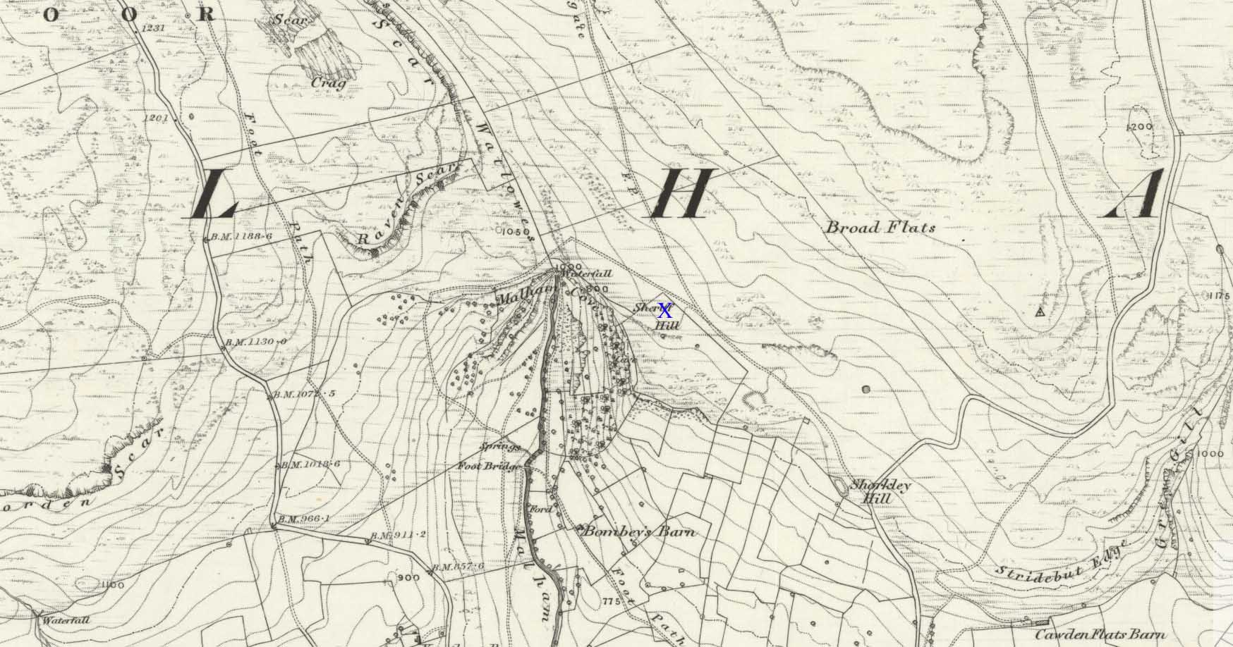
There’s nowhere to park any vehicles anywhere near this place if you wanna reach this site. And so, from Malham village, take steep eastern road up Malham Rakes (ask a local if needs be) for exaclt half-a-mile (0.81 km) where, at a bittova sharp turn in the road, there’s a footpath on your left. Walk along here for about 350 yards until you hit a straight line of walling on your left. Follow this along, about 30 yards before it turns at a right-angle. On the other side of the wall from here, a barely discernible denuded heap is in the overgrown field. That’s it!
Archaeology & History
To be found above the grand rise of Malham Cove—on its eastern side—the earliest mention I’ve found of this once-large prehistoric burial cairn was in the Cravendale travelogue of William Howson (1850). His description was only a brief one, telling us how,
“The workmen engaged on the fences have lately opened a large barrow, which is known by the local as the Friars’ Heap, near the eastern arm of the Cove, and a quantity of human bones were found.”
In Howson’s opinion he thought “the spot is much more likely to be connected with the marauding Scots than the peaceful monks”; but he was wrong on both counts. When the site was later visited and described by the great northern antiquarian, Harry Speight – aka, Johnnie Gray (1891) – he told us that the place “was much more likely to have been a British or Danish burial mound.”
Originally standing to a height of more than six-feet, the tomb has subsequently been reduced to half that height. The most lengthy descriptions of it were written by the regional antiquarian Arthur Raistrick. In his topographical literary meanderings across the Malham landscape, he gives a fine overview of its features and locale:
“Across the clints the old valley which leads to the edge of the Cove is seen, and looking upstream a grand impression of the Dry Valley, properly called Watlowes, is obtained. Across the foot of the valley a stile crosses rhe wall, and a footpath goes up the hill near to the boundary wall of the Cove; this is Sheriff Hill. At the prominent corner of the wall where the path resumes a level course, it joins the path from Malham Lings called Trougate. Between here and the road there are abundant traces of the Celtic fields, nestling under the small limestone crags that offer shelter from the northeast, evidently as unwelcome a quarter for the wind when these were occupied as today. Where the wall turns at right-angles again towards the Cove, there is a very prominent circular mound nearly a hundred feet in diameter. This is a burial mound of late Iron Age. It was dug into about the year 1845 and in addition to many human bones , fragments of an iron spearhead were found. It is to be regretted that no careful account of this excavation was preserved, as there seems no doubt that this was a multiple burial of some importance. Like other burial mounds in this district, the site was well chosen with a most extensive view which includes many notable hill summits…”
This latter remark could well have come from the pen of the old ley-hunter, Alfred Watkins (1925), who noted time and again how landscape features would seemingly connect one site with another, and another. (the modern idea of leys as ‘energy-lines’ is an American invention and wholly without merit)
A few years after Raistrick gave us his initial description, the cairn was excavated. In his short work on the archaeology of Malham Moor (1961), he wrote:
“A burial mound (that was) three-quarters removed at the time of the enclosures (about 1845) when the mound was dug as a quarry for walling stones. The remaining fragment was trenched right through and was found to be built entirely of stone with a kerb of large flaggy stone laid on the slope at the foot of the mound. Many fragments of decorated pottery were founmd under the turf cover and were associated with what appeared to be discarded gravel from the original quarrying, so may have come from the centre. At the inner edge of the kerb and under a carefully placed cover-stone, a smal oval vessel was got. This is of thick bluey-grey paste, red outside and very flaky so that part of the surface is lost on the two-thirds of the vessel which remains. Prof Stuart Piggott has reported on the pottery. Of this vessel he says — “an oval cup of the so-called ‘Incense Cup’ class: one sherd is of the wall and base of one end, the other a piece spalled off from the inside of the base. I only know of one paralle to this remarkable pot, another oval incense-cup from Far Fields, Lockton, N.R. Yorks, in the York Museum. A very odd little oval ‘cup’ of sandstone from Defford, Bredon, Worcs, in the Hastings Muesum at Worcerster is a stray find and might be of any age, and anyway only provides a vague parallel.”
Another “vessel is represented by sherd of what appears to be a small cinerary urn of collared or overhanging-rim type with the yellow-brown surface characteristic of so many pots of this class. The decoration appears to be in alternating panels of vertical and horizontal lines of uncertain width, the whole forming the so-called ‘hurdle’ pattern. The ornament is made of double lines of twisted cord, one with a right-hand and the other with a left-and twist: such ornament is widely distributed on such vessels…
“A third “vessel is represented by a few sherds with purple-red exterior, decorated with impressed cord, whipped cord and grooving. It is diffcitul to say what sort of pot is represented, but I suspect something within the food vessel class… The whole assemblage could well be contemporary and would fall withini the Middle Bronze Age of conventional nomenclature, somwhat in the middle of the second millenium BC…”
The most striking feature of this site is its position in the landscape, typical of large cairns in the Pennines and much further afield. The view to the south is extensive and would have had some bearing on its construction, as such heights allow for the spirits of the dead to move across the landscape. The huge cliffs of Malham Cove below may also have been an important factor. In the days when this tomb was built, a great waterfall existed at the Cove that has subsequently fallen back to Earth. In many traditional cultures, water is an extremely important element. Its relationship to life is obvious; but also in the Lands of the Dead water feeds the spirit on its journeys. These animistic and geomantic features are essential in looking at the nature of the placement of sites—and this at Sheriff Hill would have been no exception.
Enjoy your sojourns and meditations here…
References:
Gray, Johnnie, Airedale, from Goole to Malham, 1891.
Howson, William, An Illustrated Guide to the Curiosities of Craven, Whittaker: London 1850.
Raistrick, Arthur, Malham and Malham Moor, Dalesman: Clapham 1947.
Raistrick, Arthur & Holmes, Paul F., Archaeology of Malham Moor, Headley Bros: London 1961.