Cup-and-Ring Stone: OS Grid Reference – NM 027 487
Also Known as:
Kettle Stone
Ringing Stone
Singing Stone
Archaeology & History
This is a fascinating large coastal boulder with around 53 cup-markings on it — but whether these are all man-made is a matter of debate. Some of them may be natural. However some of the cups have lines and faint rings around them, showing that at least they’re man-made; and also in one of the large cups are placed small pebbles, similar in form to the well-known Butter Rolls, or bullaun stone at Feaghna, Ireland.
Folklore
This large boulder (suggested to have been dragged and dropped here from the Isle of Rhum in an earlier Ice Age) is known in the modern tongue as the ‘Ringing Stone’ because, allegedly, if you knock the surface hard with another stone it supposedly chimes with a metallic noise. As one of the links below shows, however, it doesn’t necessarily do the trick! Local folklore tells that if the stone is ever destroyed, or falls off its present platform of smaller stones, Tiree itself will sink beneath the waves. Other lore tells that this great rock is hollow; and another that it contains a great treasure. According to Otta Swire (1964),
“Some believe this to be a treasure of gold, others claim it to be the resting place of the Feinn who there await the call to rescue Scotland.”
References:
Royal Commission on the Ancient & Historical Monuments of Scotland, Argyll – volume 3: Mull, Tiree, Coll and Northern Argyll, HMSO: Edinburgh 1980.
Swire, Otta F., Inner Hebrides and their Legends, Collins: London 1964.
There are a number of sacred and healing wells on this small island, but this site in particular was deemed magickal by folk from far and wide. Found on the northwest slopes of Cnoc Largie (around which are other heathen spots) this legendary site had an attendant keeper of the well:
“an aged female direach, or guardian, whose uncanny powers could be commanded by a small offering of silver. Following this the cover of the sacred well would be removed in order that its waters might be ceremonially cleansed with a white clamshell prior to being stirred three times, sunwise, to the accompaniment of ritual incantations. Then three shell-fulls of the sacred water would be hurled aloft in the direction of the desired wind which, before the day was out, invariably appeared.”
This simple ritual obviously tells that it was a heathen site, seemingly one for divination and magick. Another piece of folklore (found at other wells) told that if the cover on the well were left unattended, its waters could overflow and flood the entire island.
References:
Anonymous, Exploring Historic Kintyre and the Isle of Gigha, Harlequin Press: Oban n.d.
On this “Isle of the Gods” — as some historians proclaim Gigha to mean — the ancient rites and ceremonies of local folk continued until pretty recent times. One writer narrated some intriguing pre-christian events connected to this curious and little-known place, speaking of indigenous heathen rites:
“These are in fact known to have persisted on the island until well into the early part of the (19th) century when Irish fishermen could still be seen climbing the little hill of Moinean Sitheil, in the sacred Moss of Peace below Ardminish, to pay homage to the “Old Ones” of Gigha: a pair of ancient legend-shrouded stones known as the Bodach and the Cailleach, that from time immemorial have stood upon a low green knoll below the farm of Achamore.
“Through the countless ages the strange jug-headed little Bodach and his smaller consort have kept steadfast vigil over Gigha: their mysterious aura said to guarantee its continuing fertility and prosperity as they link the thriving island of today with beliefs and traditions having roots in the earth-cults and sun-worship of primeval times. In the past folk would have honoured them with offerings of meal or milk and even now they still command considerable local affectation and respect, albeit expressed in less overtly pagan ways. And so they stand as ever upon their tiny hillock gazing out across tumbling terraces of old Cantereoch and beautiful Ardlamey Bay, inscrutable and silent, yet with a strangely ‘knowing’ air impossible to define.”
References:
Anonymous, Exploring Historic Kintyre and the Isle of Gigha, Harlequin Press: Oban n.d.
Go up Jura’s only road until it becomes a dirt-track and head along the track to the east to the natural hillock on the coast. You’ll pass the three standing stones of Knockrome before you get to this one, right by the end house.
Archaeology & History
Found in a beautiful setting, this is a thick little stone but is less than four feet tall and it may have had some shapely relationship with one of the hills (Corra Bheinn) on Jura. The Royal Commission (1984) described it merely as, “an erratic boulder measuring 3.1m in girth at the base, and 1.2m in height with its longer axis aligned roughly east and west.” Several other stones can be found nearby.
References:
Royal Commission on the Ancient & Historical Monuments of Scotland, Argyll – volume 5: Islay, Jura, Colonsay and Oronsay, HMSO: Edinburgh 1984.
Stone Circle (destroyed): OS Grid Reference – NG 552 172
Also Known as:
Cille Mhaire
Folklore
Omitted from Burl’s (2000) magnum opus, the great Scottish folklorists Otta Swire (1961) is the singular reference to the forgotten stone circle that once existed here. She wrote:
“The site of the old church of Kilmarie and of the stone circle whose proximity no doubt originally called it into being are now no longer to be seen. The ruins of the old church, I am told, were swept away by the sea during that great storm in the 1920s which also blew down the Dunvegan woods. The storm followed not long after the burial near the old church of an unknown sailor taken from the sea, and there were those who believed this to be the cause of the church’s disappearance, for, as the old Gaelic rhyme says: “The sea will search the four russet divisions of the universe to find her children,” and Kenneth MacLeod advises that a body taken from the sea should always be buried near the water’s edge, or the sea, desiring to recover her own, will flood much land in search of it.
“This church is said to have stood on the site of an older church of St. Maelrhuba (Servant of Peace) who was the patron saint of south-eastern Skye.”
References:
Burl, Aubrey, The Stone Circles of Britain, Ireland and Brittany, Yale University Press 2000.
Swire, Otta F., Skye: The Island and its Legends, Blackie & Son: Glasgow 1961.
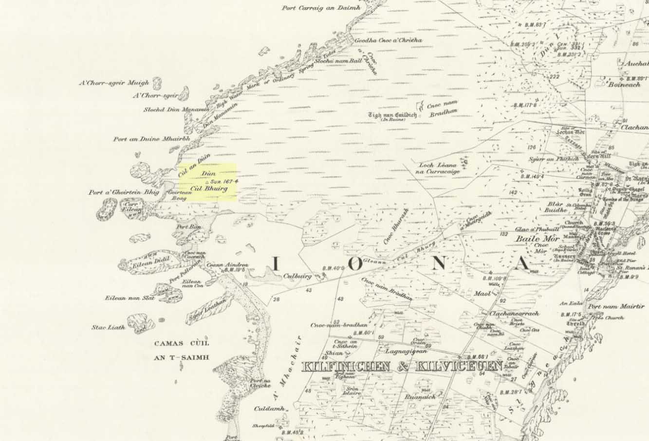
Take the road that cuts across the island, west, until you reach the stupid golf-course. Walk across it, heading for the coast (not the building at Culbuirg), then follow the little footpath up until you reach the large rocky rise about 500 hundred yards north. That’s it!
Folklore
Dun Bhuirg on 1881 map
Shown on the 1881 OS map of the region, the small remains of this Iron Age hillfort was said to be the place where St. Columba saw a rain-cloud which he predicted would bring a plague of ulcers to the people of Ireland. To prevent such a plague, Columba thence dispatched a monk called Silnan to Ireland, armed with some bread which he’d blessed. This bread was then dipped in consecrated water and given to those afflicted with the plague, who were thereafter cured.
Wee-ird……
Another tradition told that this old fort was once an important meeting place for the druids, though Geoff Holder (2007) writes that this is little more than a “spurious nineteenth century tradition” which he dismisses as without foundation. Though a short distance from here, he also told how one “Fiona MacLeod” (real name, William Sharp) one night watched the ghost of the Culdee, Oran, a couple of hundred yards away, “and so he never went that way again at night.” In truth, traditions of druidism tend to be animistic traits: legends remembered from pre-christian days, and blanket dismissals of such folklore are themselves untrustworthy—especially on this Isle of the Druids.
References:
Holder, Geoff,The Guide to Mysterious Iona and Staffa, Tempus: Stroud 2007.
Although ascribed as a holy or healing well, this site is actually a curious natural water-filled depression near the top of Dun I, on the northern side of the island. It is one of three magickal wells to be found hereby. F.M. McNeill (1954) described this Well of Eternal Youth as having a fame that had spread far and wide, saying,
“Here, through ages past, pilgrims of each generation have lingered at the enchanted hour of dawn, ‘to touch the healing water the moment the first sun-ray quickens it.'”
In doing so, devotees would recover the energies of youth once more and live a longer healthy life.
References:
Hannan, Thomas, Iona and some Satellites, W. & R. Chambers: London 1928.
McNeill, F. Marion, Iona, Blackie & Sons: Glasgow 1954.
Way off from seemingly anywhere this one – on the southern foothills of the great Cuillins, by the western edge of a seemingly unnamed loch. (most unusual) Take the Elgol road (A881) south from Broadford, nearly to its end, keeping an eye out for Kirkibost a few miles from the very end of the road. Just past here, stop and walk the track west to Camasunary a half-mile along, through the small forestry-bit, then follow the line of the trees north and keep going a bit more till y’ reach the nice stream that feeds that unnamed loch. Cross the stream!
Archaeology & History
Alexander Thom’s 1967 drawing
A fascinating little site this one! Perhaps consisting of as many as eight stones at one time, only three stand visible today. Alexander Thom (1967) reported finding other stones in this circle “being buried in the peat, but prodding revealed their position roughly” — as shown on his drawing here. There may at one time have been as many as eight stones here, but the site itself is quite small, making a ring of stones only 21-feet across (or 8 megalithic yards as Thom had it). The ruinous state of the site was put down to the stupidity of the Church of Scotland issuing “instructions that all stones in Skye were to be thrown down” a few centuries back.
Aubrey Burl’s later ‘four-poster’ summary
Aubrey Burl reported that “there were once at least 4 stones here, the tallest being of 6ft 6ins (2m) high,” and wondered whether this was one of the many ‘four-poster’ stone circles that scatter Scotland and elsewhere. An issue he seemed comfortable to proclaim a few years later in his survey of such sites. (Burl 1988) Of those stones still standing, the tallest is just 5 feet high; but there’s the impressive 11½-foot long monolith laying on the southeast edge of the ring! Mr Burl also pointed out that some
“casual digging inside the ring around 1860 uncovered a blackpolished stone about 1½ ins (4cm) long, ‘somewhat resembling a small pestle.'”
I found the proximity of the Cille Mhaire burial ground a mile west of here more than a bit intriguing (though didn’t have time to assess its geomantic relationship further). And the reported presence of prehistoric cairns nearby imply that the Na Clachan Bhreige ‘circle’ had some relationship with death and burial.
Folklore
The folkname of ‘The False Stones’ comes from that well-known tale of the site “supposedly being the remains of three men turned into stone for deserting their wives.” Something which Otta Swire (1964) thought was likely told by christian converts. It would have probably replaced an earlier tale of the stones being the site where some ancestral spirits lived. Swire also told that,
“these were once, if tradition is to be believed, Stones of Wisdom who could both foretell the future and show justice as between man and man.”
Burl (1988) also points out how,
“The name, Na Clachan Bhreige, has been variously pointed translated as ‘the judicial stones’, a place where medieval law courts were held, as in several other Scottish rings. It has also been interpreted as ‘the stone of lies, or falsehood.'”
References:
Burl, Aubrey, Four Posters: Bronze Age Stone Circles of Western Europe, BAR: Oxford 1988.
Grinsell, L.V., Folklore of Prehistoric Sites in Britain, Hale: Newton Abbot 1976.
Swire, Otta F., Skye: The Island and its Legends, Blackie & Sons: Glasgow 1961.
Thom, Alexander, Megalithic Sites in Britain, Oxford University Press 1967.
Thom, A., Thom, A.S. & Burl, Aubrey, Megalithic Rings, BAR: Oxford 1980.
This ‘hill of the big cairn’ is near the top end of the island, past the cup-marked stones of An Carn, just beneath the top of the prominent knoll, a half-mile east of the track. It’s about 200 yards from the summit on the southern side of the hill. More than 50 feet across and about 3 feet high, what may be kerb-stones can be seen on the west-side of the tomb. The Royal Commission (1984) lads tell us that,
“its northern edge is buried under field-gathered stones, and a small enclosure of comparatively recent date overlies the cairn.”
References:
Royal Commission on the Ancient & Historical Monuments of Scotland, Argyll: volume 5 – Islay, Jura, Colonsay and Oronsay, HMSO: Edinburgh 1984.
Very close to being at the top of the island. If you do manage to get here take a gander at the legendary Gulf of Corryvreckan: one of the largest whirlpools on Earth, where the cailleach swirled her stuff when angry! This is the ‘hill where sorrel grows,’ and where George Orwell wrote 1984 – but more important for us is where the Royal Commission for Historic & Ancient Monuments of Scotland (Argyll, vol.5) designated that,
“a stony mound about 5.5m in diameter and 0.5m high, situated on the crest of the ridge east of Barnhill, appears to be a prehistoric burial cairn.”
Sadly I never managed to check this out when I was last up here as I didn’t know it was here!
References:
Royal Commission on the Ancient & Historical Monuments of Scotland, Argyll: volume 5 – Islay, Jura, Colonsay and Oronsay, HMSO: Edinburgh 1984.