From Pitlochry town centre, walk down the A924 high street as if you’re going to the Blair Atholl Distillery, but just before it take the right-turn and go over the river, and just keeping walking along this road for a third-of-a-mile (0.5km) until your reach a small small on your left that swerves up the hill (there’s a little signpost here saying Cluny Path to Strathtay). Go up and across the main road, then just keeping walking up the dirt-track, which becomes a footpath, and heads further uphill into and through the woodland. Make a bittova daydream from the walk up here, making sure to keep to the path closest to the burn (stream) on your left. Eventually when it levels out, you’re very close. Just keep on the same track and, where it meets up with another, bear left and about 100 yards along, on a small rise in the trees on your right, you’ll see these old stones peeking out. Keep your wits about you!
Archaeology & History
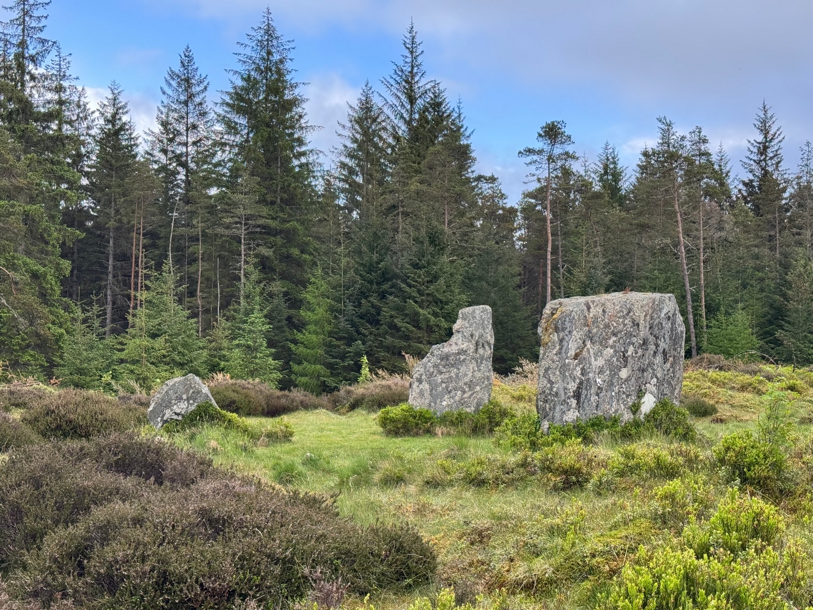
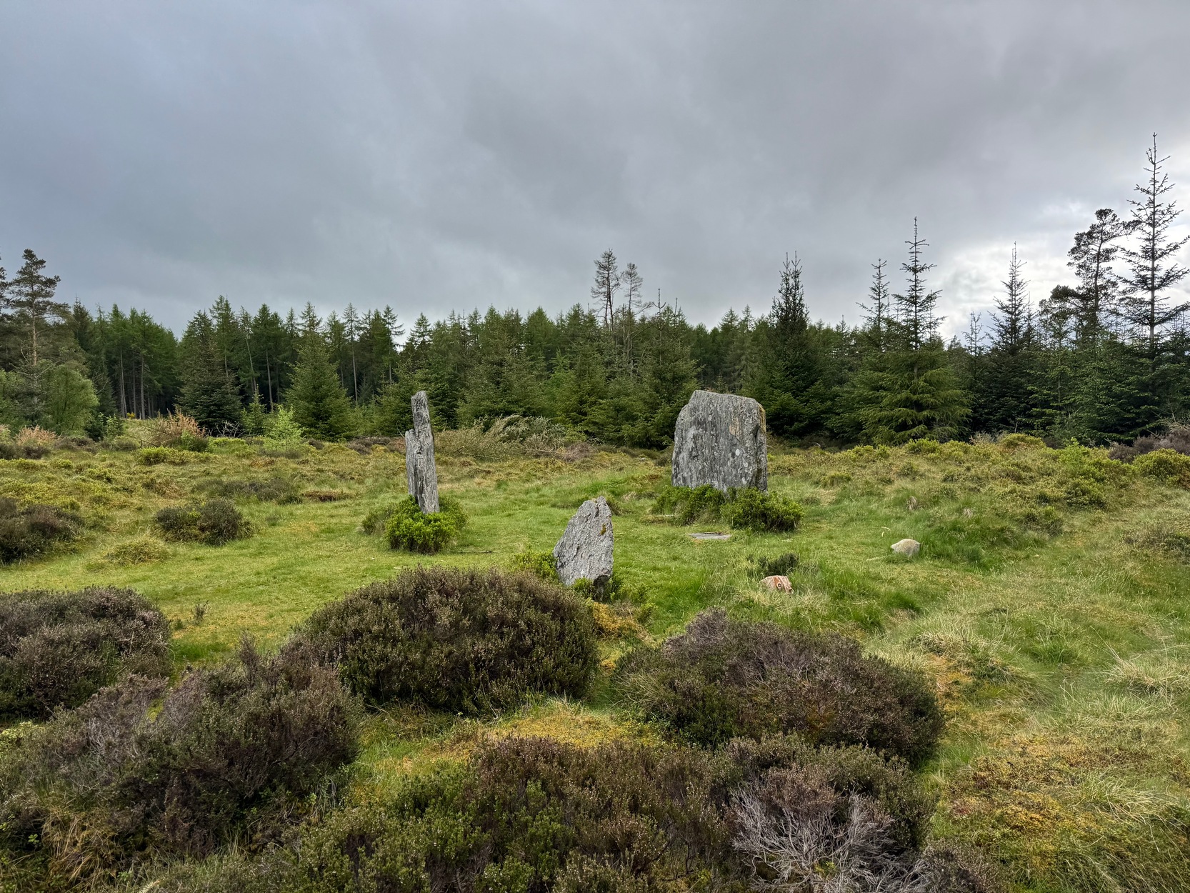
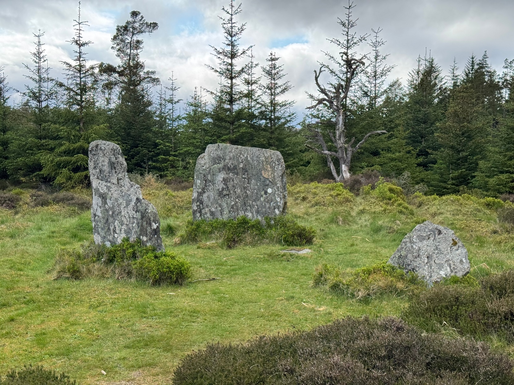
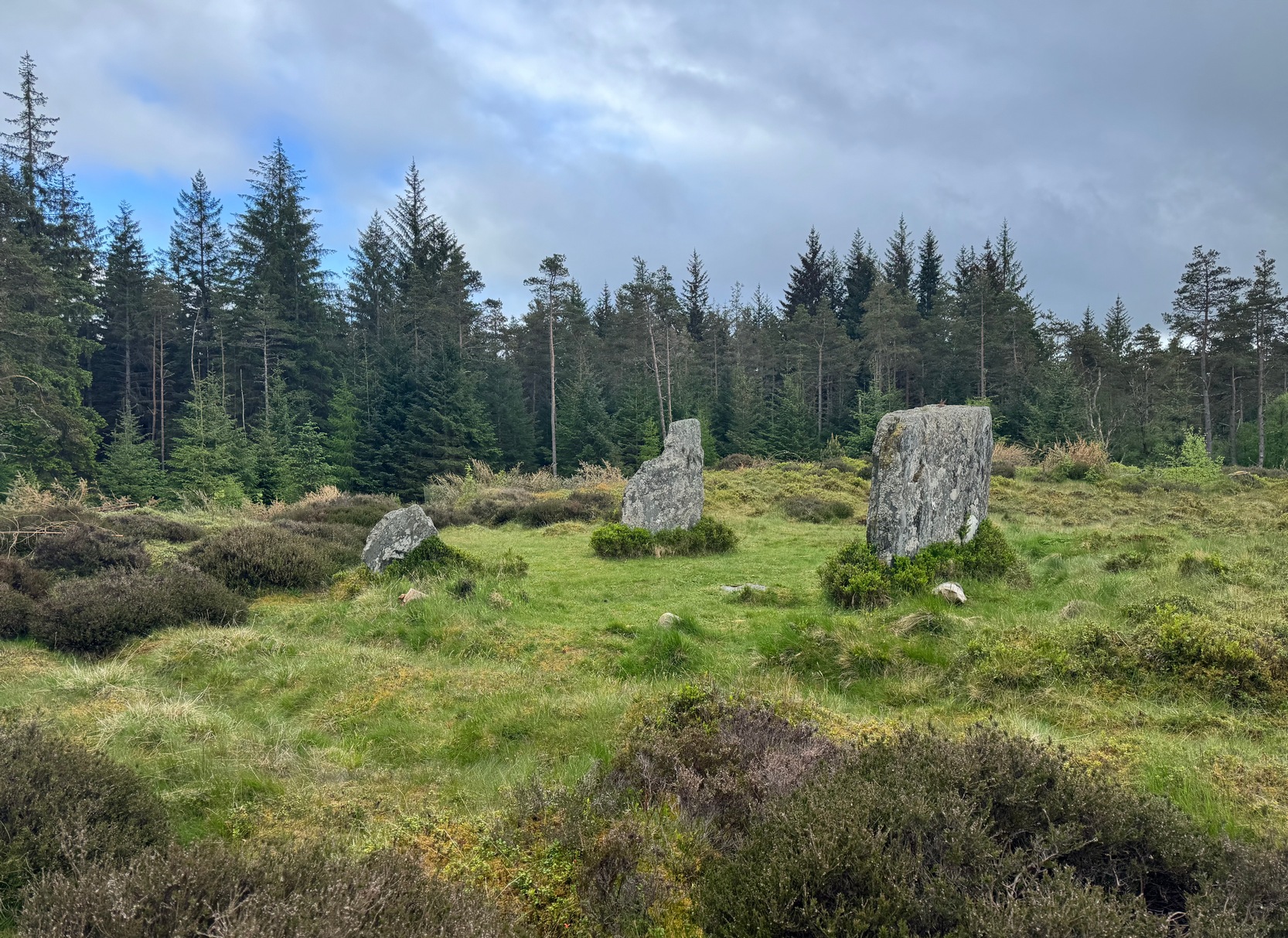
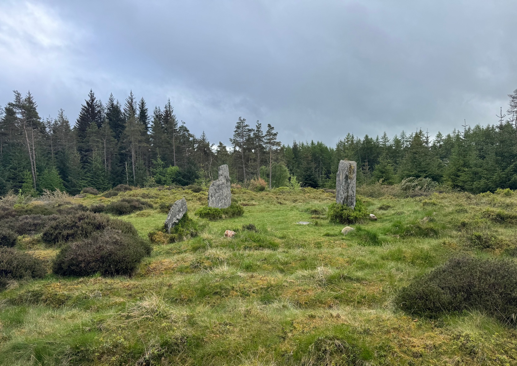
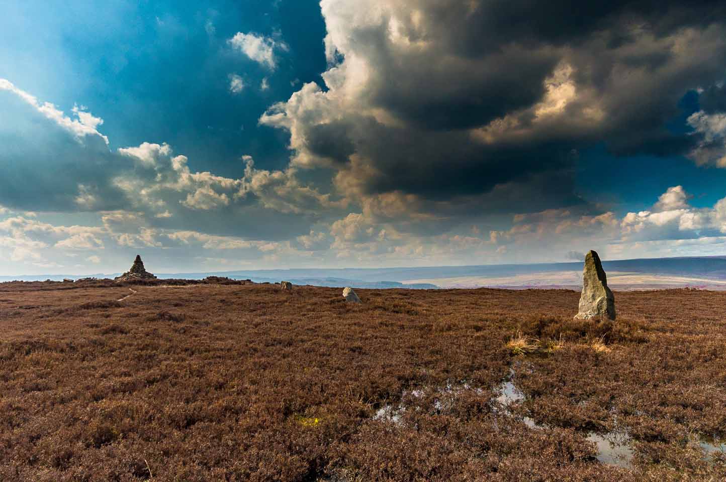
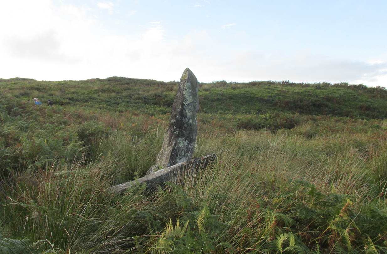
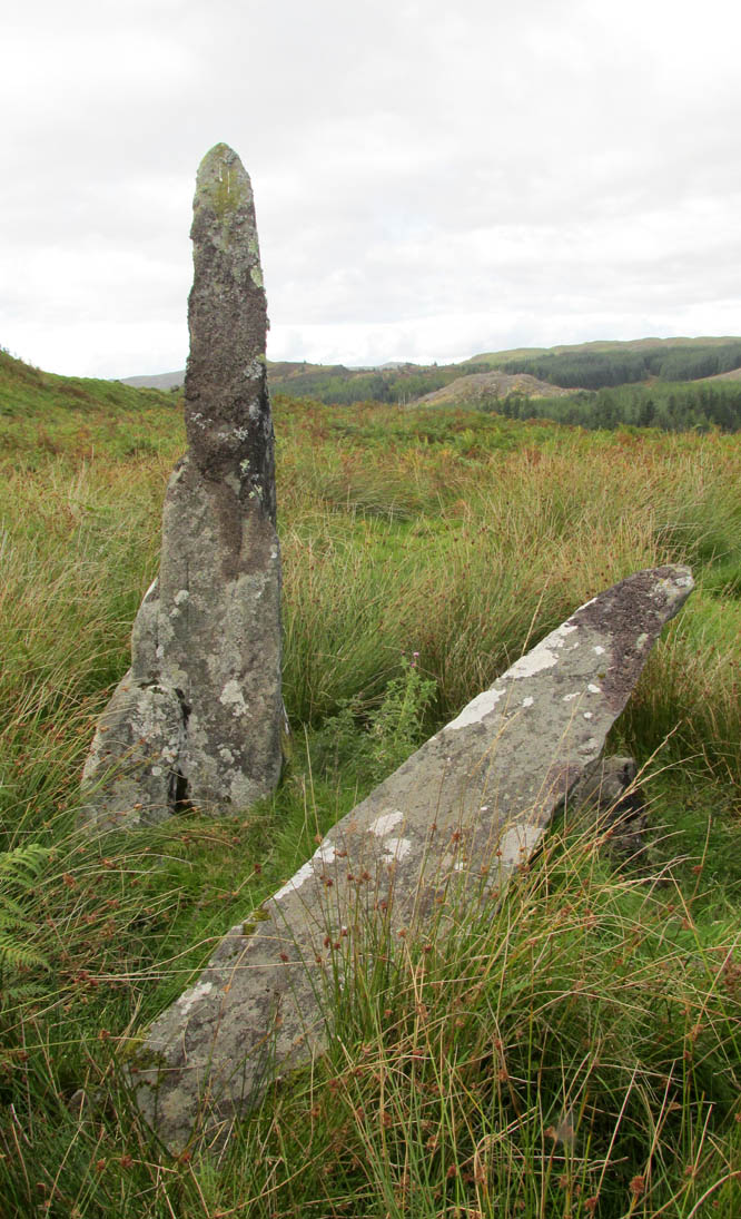
Clachan an Diridh looking E
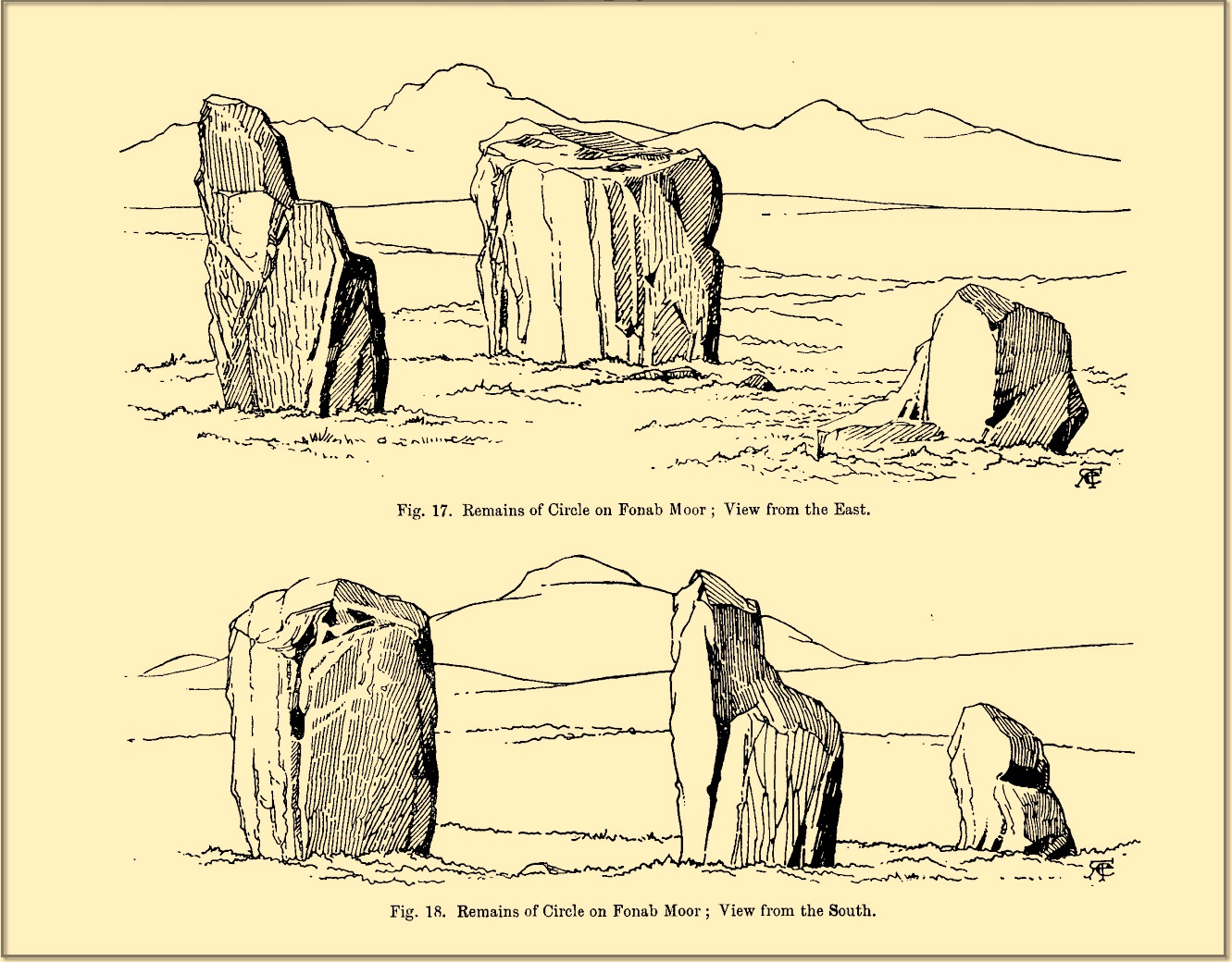
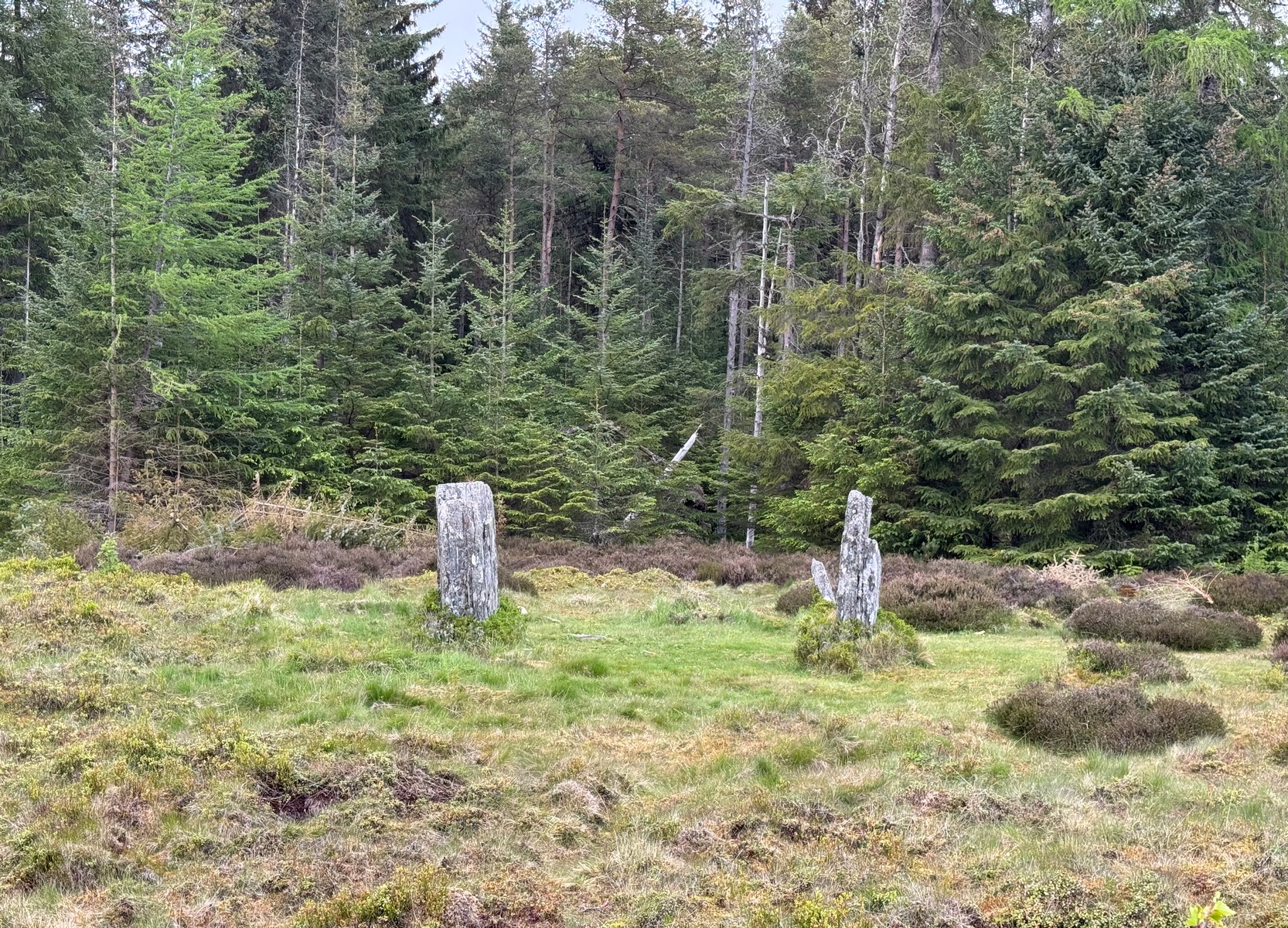
Sat high up on open moorlands with views all round… is what this site used to look like. Sadly, the forestry commission have almost completely enclosed this prehistoric site, making any view of the surrounding landscape all but impossible. I’m not the first and won’t be the last person to be pissed-off by such thoughtlessness. Alexander Thom made mention of it too. After making an initial assessment of the astronomical alignments at these stones in 1967, “when we returned to measure the horizon we found that trees had been planted round the stones and so we failed.” (Thom 1990) Not good.
On my first visit here, as I entered this “stone circle” my first impression was that it wasn’t a circle at all, but the remnants of a megalithic stone row! Thom thought the same. It’s the slender thin stature of the stones that do it to you: they almost cut the air and point the enquiring nose dead straight along the same angle that all the stones have been deliberately aligned to. I assume they’ve had a similar effect on other people over the years.
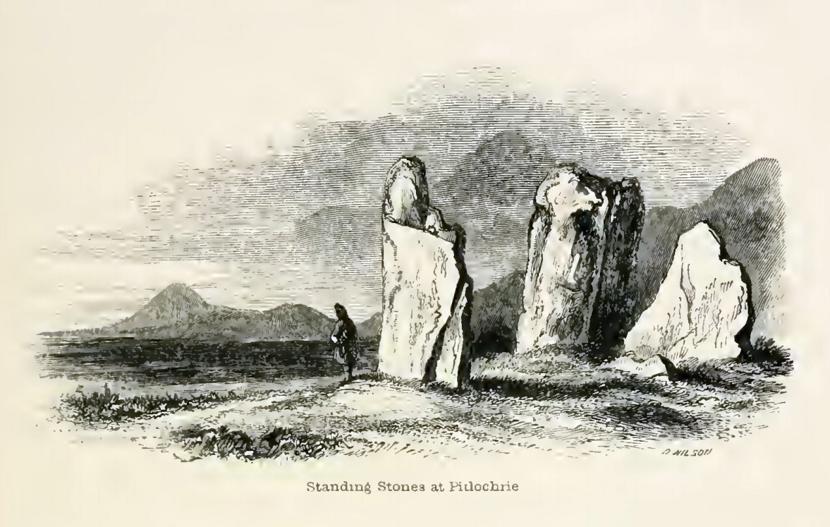
The Clachan an Diridh, or the Stones on the Ascent, were first mentioned in Dan Wilson’s (1851) major survey and who was so impressed by the view from here and its setting in the landscape that he compared its visage to Stonehenge. Were it not for the short-sightedness of the Forestry Commission destroying the view, most would no doubt agree with Wilson’s sentiments. From these olde stones, he told:
“One of the great level Highland moors stretches away beneath the eye, like a dark waveless lake, contrasting with the distant heights, among which Ben Lawers rears its pyramidal summit to an elevation of upwards of 4000 feet above the level of the sea. Amid this wild Highland landscape the huge standing stones, grey with the moss of ages, produce a singularly grand and imposing effect; and from the idea of lofty height which the distant mountains suggest, they convey a stronger impression of gigantic proportions than is produced even by the first sight of the giant monoliths of Salisbury Plain.”
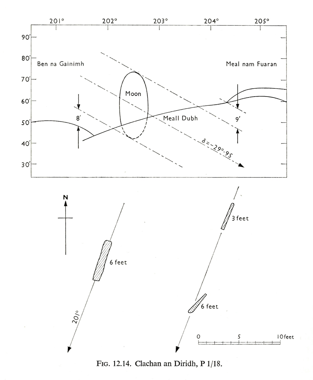
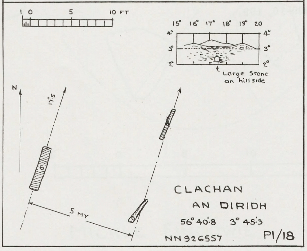
Thom’s initial moonset alignmentThom’s 1980 ground-plan with marker stone
The giant figure of Ben Lawers, if we could see it today, would rise to the southwest 20 miles (32km) from here; and the great pyramidal fairy mountain of Schiehallion would be equinox west, 13 miles (21km) away. Yet curiously when Alexander Thom surveyed the outlying hills, he didn’t think either of these mountains had any worth, astronomically speaking that is. Yet Lawers in particular would be the largest point on the southwestern horizon, rising in the distance, way beyond the wide rolling U-shaped glen of Strathtay to where the landscape changes into more rugged dynamic uplands. And the importance of Lawers as a place in prehistory is shown by the mass of petroglyphs across its slopes—particularly the side you could see from Clachan an Diridh.
Instead, Thom (1967) looked much further to the southwest—south-southwest in fact—where he initially thought that there was an alignment to the major southern moonset ten miles away above the rugged hill of Meall Dubh, framed on either side by the mountain peaks of Meall nam Fuaran and Beinn na Gainimh. Aubrey Burl (1988) told how Thom later discounted this alignment and instead turned his attention a full 180° where a large stone on the hillside to the north-northeast caught his theodolytic eye. This marked an alignment towards the peak of Ben Vrackie:
“There is little doubt,” he wrote, “that this is a lunar site showing perhaps…at the major standstill. Could one side of the southern 6ft high stone possibly have indicated the setting point of the Moon at minor standstill?” (Thom 1990)
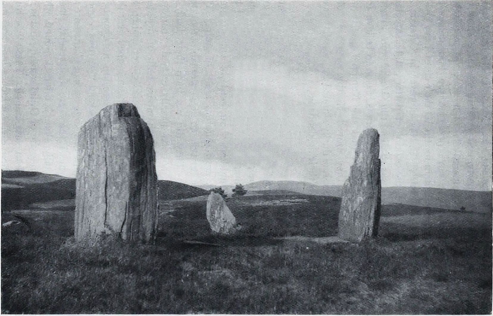
Clachan an Diridh in 1851Clachan an Diridh, c.1920
Thom looked at these stones and the landscape with the mind of an astronomer, whereas I’m more in preference of the aborigine who sees the feel of the landscape to discern relationships and meanings. Sometimes, of course, the sky and the landscape come together and that universal mythic union of heaven and Earth finds importance at a site. I have little doubt that such a mythos was once known here, on the moorland plateau, under the clear stars with the darkness reaching to speak with Lawers and other bones of landscape in the solid darkness of mountain silhouettes and fading horizons. Many a sleep at this site would have touched minds with Wonder…
Anyway, all that aside…
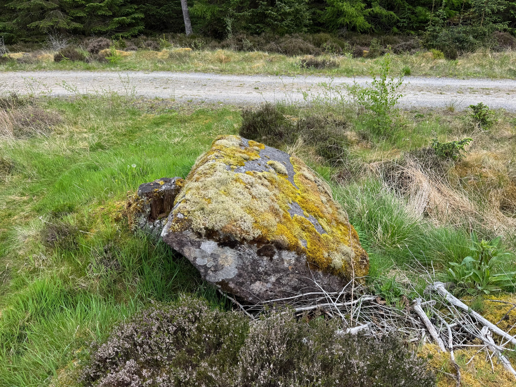
Large fallen stoneSite on the 1899 OS-map
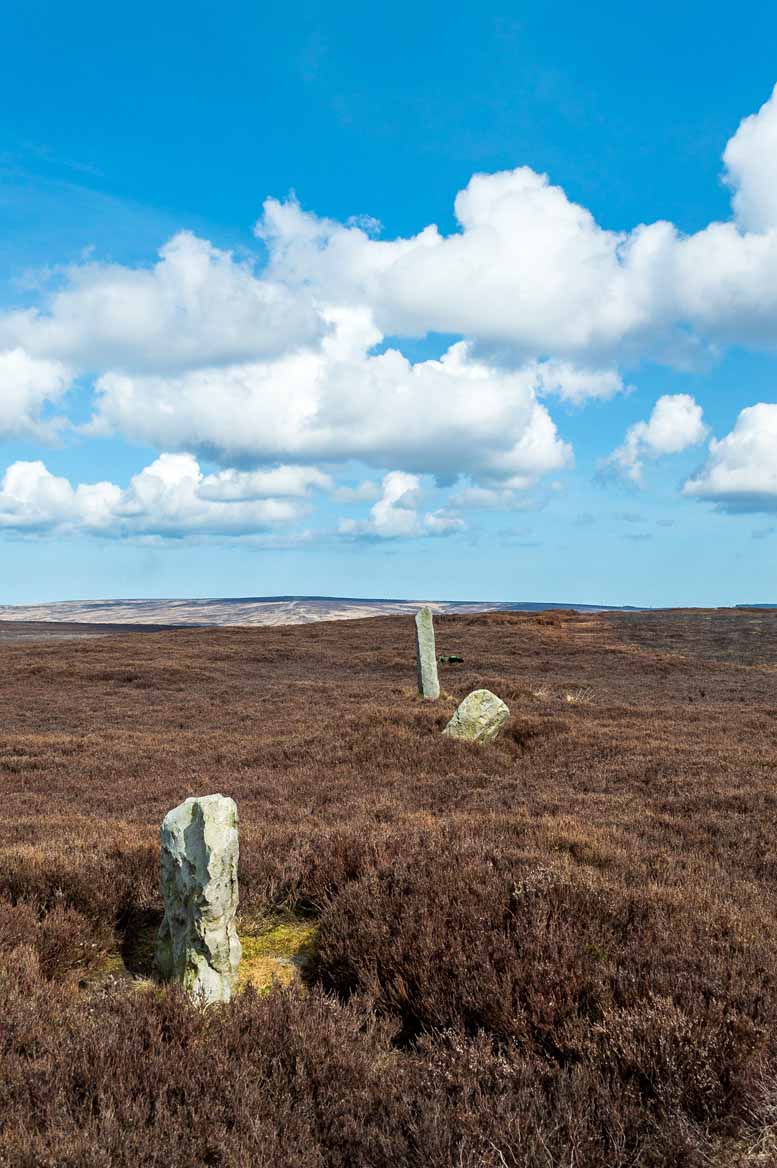
These megaliths have been classified as one of Aubrey Burl’s “four posters”, i.e., a rough square of four megalithic uprights, in spite of there only being three standing stones here. Even when Dan Wilson (1851) wrote about the place there were just three of them. However, down the slope from the stones, just off the recent trackside, there’s a decent contender for the fourth stone lying on its side in the undergrowth, half-covered in moss. It’s certainly fallen or rolled down the slope and its size and shape suggest that it may once have stood upright. Have a thoughtful fondle of it while you’re here.
The ‘circle’ was highlighted on the 1899 OS-map and, a few years later, was visited and surveyed by the great Fred Coles (1908) and like Dan Wilson before him, told the view from here to be “very grand.” He continued:
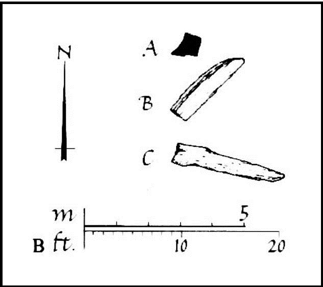
Coles 1906 planColes’ views, from S & E
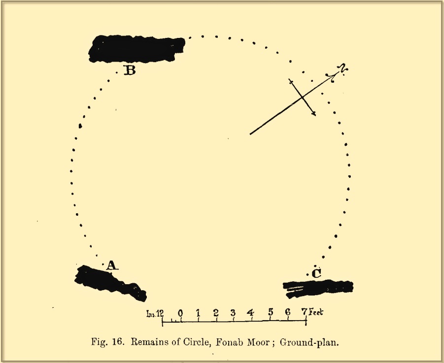
“In local parlance this group is known as the Four Stones. This must be a fairly old name handed down through some generations; because, for at least fifty-seven years past, only three Standing Stones have remained in situ. These three Stones are arranged as shown in the plan…in a group forming in its now imperfect condition a triangle which, measured from the centres of the Stones, has its SE side 11 feet 6 inches long; its SW side 12 feet 3 inches ; and its north side 16 feet 3 inches. Fragments of the demolished fourth Stone lie about the ground; but there is no clear indication of its original position. The South Stone, A, is 3 feet 7 inches in breadth, 5 feet 10 inches in height, and from 12 to 4 inches in thickness. The West Stone, B, 6 feet in height, measures 5 feet at the back, and 4 feet 10 inches at the front, and is 18 inches in thickness. The East Stone, C, at its outer angle is 3 feet 3 inches above ground, and leans inward. All the blocks are of quartziferous gritty sandstone, the East Stone being particularly rough and fissured. A large fragment lying near it seems to be a portion of it. The Stones are set upon a fairly true Circle with a diameter of 15 feet 4 inches. One feature quickly arrests notice: this is, that the broader faces of these Stones are not set even approximately upon and in line with the circumference, but nearly parallel with each other—an arrangement quite unlike the setting of Stones in the many other Circles hitherto surveyed.”
When Burl (1988) added this site to his Four Posters survey he merely echoed Coles’ early description, adding that, in his view, the standing stones that we see today were probably, originally, “set out on the circumference of a circle 20ft (6.1m) in diameter.”
I think it’s likely that there would have been more prehistoric sites in the vicinity, but a notable oddity is the almost complete absence of other recorded sites anywhere nearby. Of course, if there was anything, those thoughtful Forestry Commission heads would have destroyed it. We are left, simply, with the old but reliable notes of Messrs Dixon (1923) and Mitchell (1925) who told that, in their days, other remains did exist nearby in the form of ancient cairns and hut circles—‘Pictish’ according to tradition. If we’re lucky, some damaged parts of them might still be found at the edges, a short distance to the north west…
Folklore
In Hugh MacMillan’s (1901) gorgeous literary sojourn along Strathtay, he strayed somewhat from his otherwise historical notices by telling that here,
“on the highest part of the moorland…is a group of ‘clachan iobairt’, or stones of worship, where the Druids of old performed their mysterious rites, going round the circle of standing stones from east to west with the sun, or the ‘car deasal’, the lucky side, when they wished to invoke a blessing upon their friends, and going round the circle in the opposite direction, from west to east, the ‘car tuathsel’, or unlucky side, when they wished to pronounce a curse upon their foes.”
Whether this was what Hugh Mitchell (1923) meant when he referred to the traditions surrounding Clachan an Dirirdh we don’t know, but he echoed MacMillan’s account (though made no reference of his words), also adding that it was a site that “was visited on the first of May” or Beltane by some local people….
References:
Burl, Aubrey, Four Posters: Bronze Age Stone Circles of Western Europe, BAR 195: Oxford 1988.
Burl, Aubrey, A Guide to the Stone Circles of Britain, Ireland and Brittany, New Haven & London 1995.
Burl, Aubrey, The Stone Circles of Britain, Ireland and Brittany, Yale University Press 2000.
Dixon, John H., Pitlochry, Past and Present, L. Mackay: Pitlochry 1925.
Kennedy, James, Folklore and Reminiscences of Strathtay and Grandtully, Munro Press: Perth 1927.
Liddell, Colin, Pitlochry – Heritage of a Highland District, PKDL: Perth 1993.
MacMillan, Hugh, The Highland Tay: From its Source to Dunkeld, H. Virtue: London 1901.
Mitchell, Hugh, Pitlochry District: Its Topography, Archaeology and History, L. Mackay: Pitlochry 1923.
Omand, Donald (ed.), The Perthshire Book, Birlinn: Edinburgh 1999.
Stevenson, J., “Prehistory,” in Omand’s The Perthshire Book, Edinburgh 1999.
Thom, Alexander, Megalithic Sites in Britain, Oxford University Press 1967.
Thom, Alexander, Megalithic Lunar Observatories, Oxford University Press 1971.
Thom, A., Thom, A.S. & Burl, H.A.W., Megalithic Rings, BAR: Oxford 1980.
Thom, A., Thom, A.S. & Burl, Aubrey, Stone Rows and Standing Stones – volume 2, BAR: Oxford 1990.
Wilson, Daniel, The Archaeology and Prehistoric Annals of Scotland, Sutherland & Knox: Edinburgh 1851.
Acknowledgements: Huge thanks for use of the Ordnance Survey map in this site profile, reproduced with the kind permission of the National Library of Scotland.
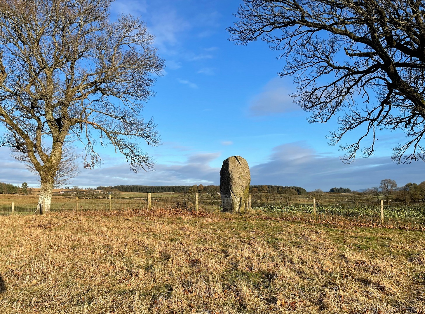
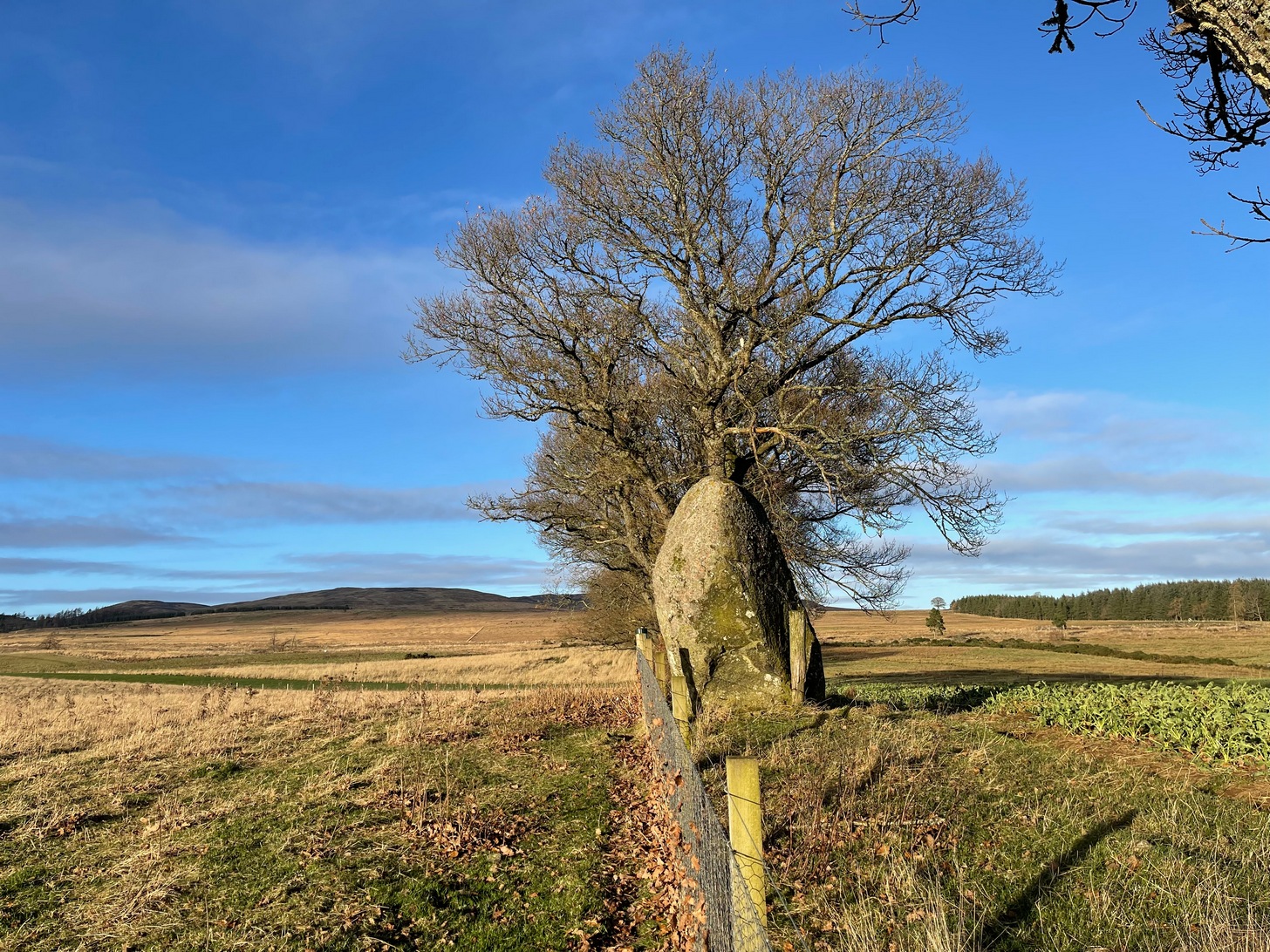
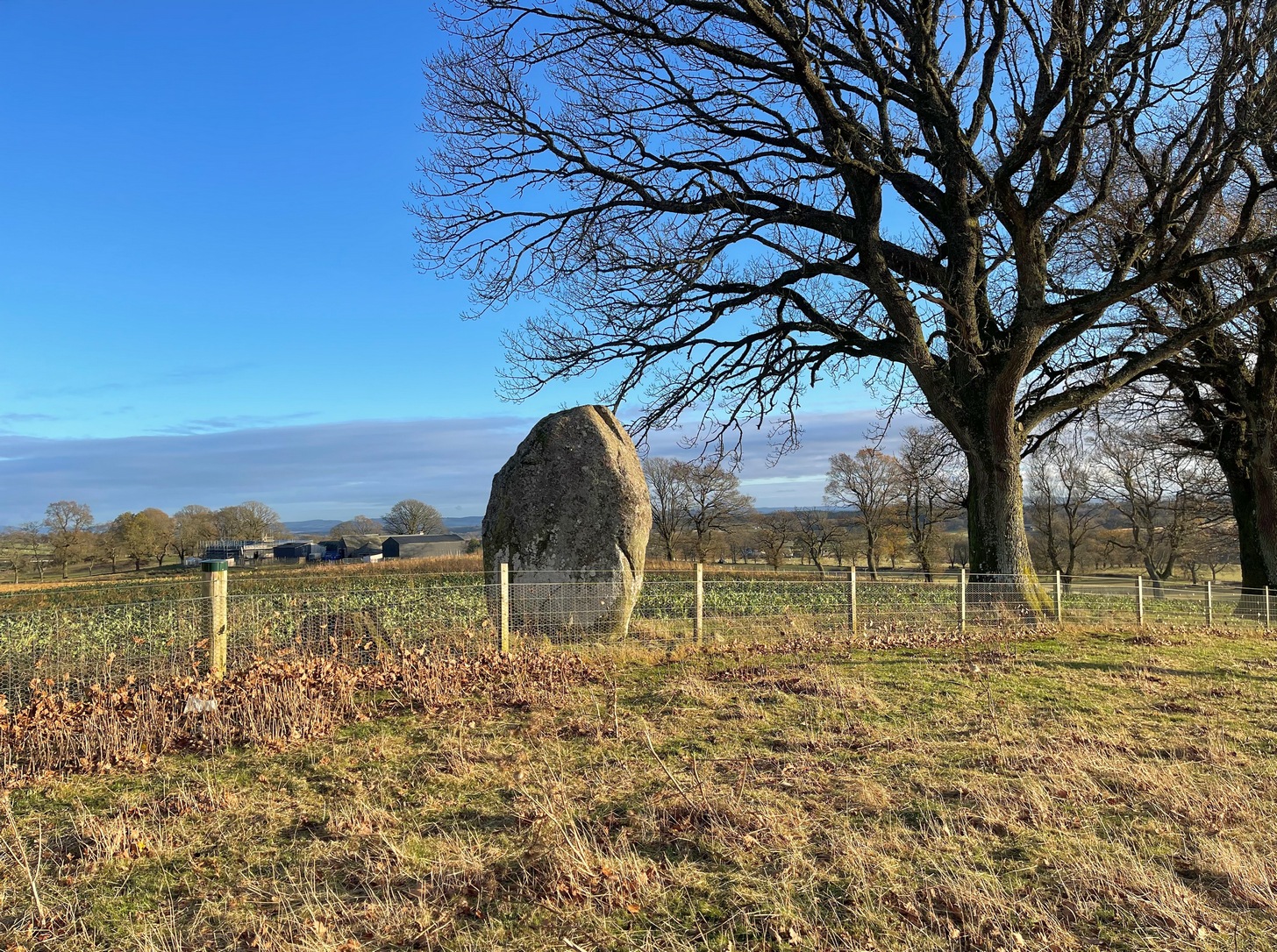
Take the tiny long winding B8063 road that runs west off the A9 at Luncarty, meandering eventually to the entry of the Sma’ Glen. If you’re coming via Luncarty, after going west for 8 miles (12.9km) you pass the hamlet of Harrietfield and just a few hundred yards further a dirt-track on your right goes uphill to Milton. If you’re coming via Crieff/Sma’ Glen direction, along the B8063 road, cross the Bridge of Buchanty and after nearly 3 miles (4.7km) just past a bit of a hairpin, you’ll see the track up to Milton on your left. Walk up, past all the newly modernised houses and go through the gate, bearing right where, in the field on your right (thru another gate) you’ll see this big fella standing alone 200 yards to the east along the fence-line.
Archaeology & History
Looking N to Crochan Hill
This is a bit of a hidden beauty! Standing nearly ten feet tall on the crest of an elongated ridge with the land ever so gently declining either side of its proud stand, it beckons the impression of partners long since gone (or something truly olde)… and so it proved to be. Very little has been written about the place, despite its impressive stature. It seems to have been described firstly in J.W. Thomson’s essay on the local parish in April 1837 (subsequently published in the NSA in 1845) where, ascribing it as usual to the druids of olde, he told that,
“at the western extremity of Logiealmond, there is one remarkable block about 12 feet high and 18 feet in circumference, standing upon its narrow end, with three other stones in its immediate vicinity. It is commonly called the Kor Stone.”
Kor Stone, looking SEFred Coles’ 1911 sketch
William Marshall (1880) also mentioned these three additional standing stones, saying that they were “apparently part of a row.” But they are long gone and we know not what became of them. They were probably uprooted and included in some of the nearby walling or buildings (quite a lot of suspicious-looking stones scatter the edges of many fields around Logiealmond). If we look closely at the surface of our Kor Stone, in earlier times someone has fixed metal loops into the monolith to make it part of an early fence or gate.
The stone was highlighted on the 1867 OS-map of the area and described in the accompanying Name Book,
“Carse” Stone on 1867 map
“A stone about ten feet high, supposed by some people to be the remains of a Druidical Circle, by others to be a mark on a division of lands: in support of the latter supposition they bring forward the fact of a large stone at Dunkeld and one near Fowlis – both similar to this one – and The Carse Stane being in the same straight line.”
The great Fred Coles (1911) also gave the place his attention, but apart from a brief description of its size and position, he found no additional lore about the other three stones, telling us simply:
“It is an imposingly large and erect block of rugged whinstone, 9 feet 9 inches in height, with a basal girth of 15 feet 10 inches, but at about midway of its height the girth increases to fully 17 feet. The view…shows the Stone as seen from the east.”
In truth, the location of this giant stone on the ridge strongly suggests it was once part of a much greater megalithic neolithic monument. But whatever that might have looked like, we may never know. It’s an awesome site though. Well worth checking out if you’re in the area.
Finlayson, Andrew, The Stones of Strathearn, One Tree Island: Comrie 2010.
Marshall, William, Historic Scenes in Perthshire, William Oliphant: Edinburgh 1880.
Thomson, J.W., “Parish of Moneydie,” in New Statistical Account of Scotland – volume X: Perth, William Blackwood: Edinburgh 1845.
Acknowledgements:Huge thanks for use of the Ordnance Survey map in this site profile, reproduced with the kind permission of the National Library of Scotland.
From Pickering take the moor road towards Whitby (A169) for approx. 12 miles. After passing the Fylingdales Early Warning radar on the right (you can’t miss it), the road dips down to cross Eller Beck as a dog leg. After a half mile turn off left (west) towards Goathland (signposted). Follow the road under the North Yorks Moor railway bridge and after a third-of-a-mile the road turns slightly left. Park in the little layby and follow the track onto the moors. Cross the small stream and walk along the narrow track through gorgeous heather for a mile and a half. Ahead you will see Simon Howe prominent on a ridge, with a stone row leading to it.
Archaeology & History
Not included in either of the giant megalithic alignments surveys of Burl or Thom, it seems that the first archaeological reference to this site was made by Raymond Hayes (1988). He visited the site in 1947, shortly after a moorland fire had cleared away all the vegetation, allowing for a clearer view of the stones and, after his brief description of the adjacent Simon Howe tomb, he told that,
“The ridge is also the site of what is an unusual feature for the moors: a stone alignment consisting of three, formerly five upright stones that lead to a low eroded cairn c.65m to the south(west). A moor fire in 1947 revealed the fourth, fallen stone, and I was able to locate the socket of a fifth.”
Raymond Hayes 1947 photoStone row on GoogleEarth
From hereon, Hayes seemed to more interested in seeking out and describing a large number of flints that he found scattered on the ground around Simon Howe and its associated monoliths than the stones themselves. Very sad… The exact position of the missing fifth stone seems to be shown on Hayes’ plan as being closest to the cairn, about 10-15 yards away, but no trace of this remains. However, of the remaining monoliths, they are all clearly visible from the air on Google Earth!
The most southerly of the four stones (SE 83016 98119) stands just over 3 feet tall and the second upright, leaning at an angle, is just slightly taller, with the tallest of the three uprights at the northeastern end, being some 6 feet tall. The fourth fallen stone (SE 83031 98142) lies just beyond this in the heather and which, if resurrected, would stand some 4 feet in height. The length of the row, stone-to-stone, is just over 29 yards (26.6m). I’m not aware if this site has ever been assessed as having an astronomical function, but its angle to the northeast might suggest a lunar rising. Perhaps more pertinent would be another prehistoric cairn that can be seen less than 100 yards away past the northern end of the stone row: as North is the cardinal direction symbolizing Death in traditional lore…
Roughly halfway between the staggering standing stone at Kintraw and the farmhouse of Salachary a coupla miles east along the A816 road to Kilmartin, a small overgrown car park nearly hides on the south-side of the road, just below the forestry. 50 yards west of this, a small track winds uphill. 650 yards (0.6km) up here, once it levels out, a hairpin in the track veers NW; ignore it, instead walking into the marshy grass in front of you (south) for 50-60 yards up and round the small rocky crag. Once you get round the edge of this, immediately east, you’ll see one of the tall monoliths 50 yards ahead of you.
Archaeology & History
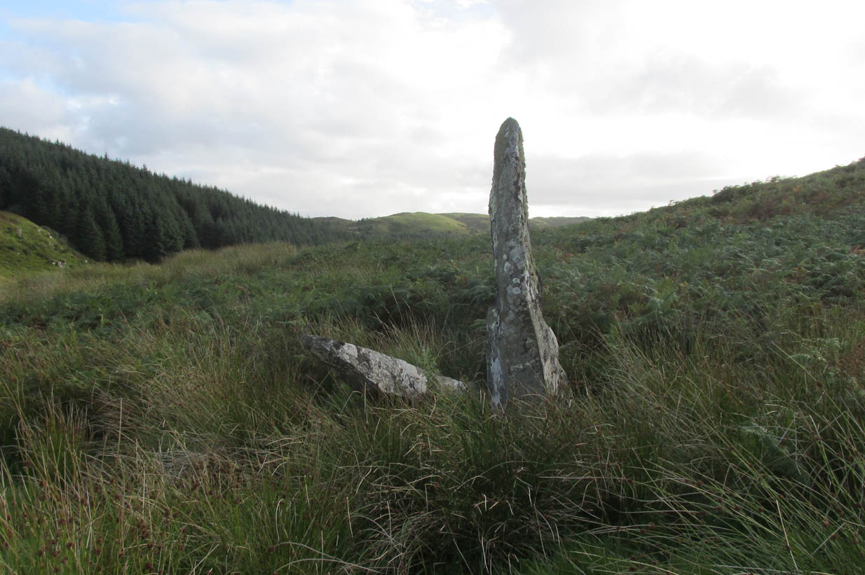
Rediscovered in recent times by Marion Campbell (1962), this damaged row of three tall standing stones is cited in Swarbrick’s (2012) poorly-arranged survey as being “difficult to find in broken ground”; although patience brings the stones clearly into sight for any explorer. They’re big too! Sadly only one of them still remains fully upright—but that one’s nearly 9 feet tall!
In Miss Campbell’s initial description of the site, following their rediscovery, she told how,
“A chance sighting led to the discovery of a group of three monoliths, one erect, one sloping and one prostrate, on the West side of a wide glen leading S from the upper part of the Bealach Mor; the site commands a fine view into the northern hills. The spot is about 550ft above sea level and this is therefore the highest group of standing stones so far recorded in the area.
“The erect stone is 8ft 4in x 2ft x 1 ft, lozenge-shaped in section, with a pointed top. The leaning stone, also lozenge-shaped, is 10ft x 1ft 8in x 1ft, and pointed. The fallen stone is over 11ft x 2ft wide, too deeply buried in turf for the thickness to he measured. The stones appear to have stood in line, the nearest points of the first and third stones 9ft apart and the line joining them running north and south. Along a ridge running S behind the stones are a number of small ruins, oval and rectangular, in old cultivations. No surviving placename has been recovered for the site so far.”
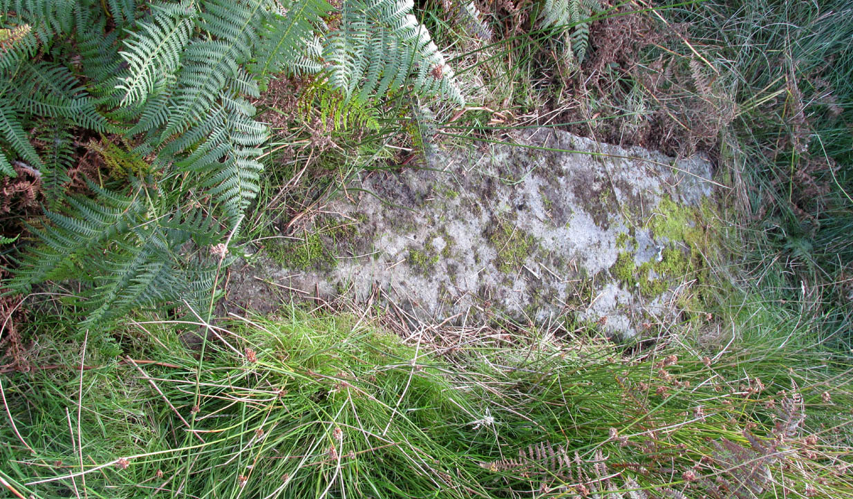
Section of the fallen stoneLooking west
Indeed, no subsequent investigation has led to either an early name nor any traditions about the site, and the stones cannot be found on any early maps of the area. A pity, as they’re quite impressive stones and would have had some old stories known of them in ages gone by.
Twenty years after Miss Campbell’s discovery, in May 1982, the stones were visited and surveyed by the Royal Commission lads. Their description very much tallied with Miss Campbell’s, but it’s worth citing anyway. They told us that:
“On a terrace on the W side of an unnamed valley to the S of Bealach Mor and about 850m SW of Salachary, there is a setting of three large standing stones which is aligned from N to S. Only the N stone is still upright; it measures 0.7m by 0.72m at the base and rises with straight sides to a pointed top at a height of 2.75m. The central stone is of similar proportions, but it now leans to the NE at an angle of about 15° to the horizontal. The S stone, which measures 3.4m by 0.65m has fallen with its top to the SE.”
Royal Commission planAlexander Thom’s plan
Around the same time, Clive Ruggles (1984) assessed the Salachary stones for any potential astronomical alignments and found—as Alexander Thom & Aubrey Burl did in their own survey (1990)—that as they pointed virtually north-south they stood beyond any solar or lunar functions. Thom found the stones align almost perfectly north-south, with a notch in the southern horizon at 178°, and on the northern horizon the hilltop of Meall Reamhar at 2° west of north. This northern line may relate to the airt of death, although no other immediate archaeological remains have been found to fortify this idea (however, other unrecorded standing stones are close by and their relationship with Salachary has yet to be adequately assessed).
Aubrey Burl’s first description of this stone row told us:
“There are three stones in a N-S row situated on a terrace on the W side of a glen. The N stone, with a pointed top, stands 8ft 4 (2.5m) high. The central stone leans dramatically at 20°. It is 10ft (3m) in length. The S stone is prostrate and half-buried. It is 11ft (3.4m) long. The row is about 13ft (4m) long. From the site there is a fine view of the northern hills.”
Looking north
In truth, the main north-south axis relates to the more open geological avenue of the landscape. Both the east and west are all but blocked by crags and hills, and the stones seem to have been positioned to echo the hollowed section of the landscape. The land runs in curious geological folds and has a distinct genius loci which I enjoyed in differing (usually wet) conditions when I used to live nearby. The site is well worth a walkabout if you’re in the area – and there are more unrecorded stones still hiding in Nature’s rocky folds nearby.
References:
Burl, Aubrey, From Carnac to Callanish, Yale University Press 1993.
Campbell, M. & Sandeman, M., “Mid Argyll: An Archaeological Survey,” in Proceedings Society Antiquaries Scotland, volume 95, 1964.
Campbell, Marian, ‘Salachary, Kintraw’, in Discovery & Excavation Scotland, 1962.
Ferguson, Lesley, “A Catalogue of the Alexander Thom Archive Held in the National Monuments Record of Scotland,” in Records in Stone (ed. C. Ruggles), Cambridge University Press 1988.
Royal Commission on the Ancient & Historical Monuments of Scotland, Argyll – volume 6: Mid-Argyll and Cowal, HMSO: Edinburgh 1988.
Ruggles, Clive L.N., Megalithic Astronomy, BAR: Oxford 1984.
Ruggles, Clive L.N., “The Stone Alignments of Argyll,” in Records in Stone (ed. C. Ruggles), Cambridge University Press 1988.
Swarbrick, Olaf, A Gazetteer of Prehistoric Standing Stones in Great Britain, BAR: Oxford 2012.
Thom, A., Thom, A.S. & Burl, Aubrey, Stone Rows and Standing Stones – volume 1, BAR: Oxford 1990.
Weston, Garth, Monuments and Mountains, Ashridge: Bakewell 2007.
Acknowledgements: This site profile could not have been written without the help and of Nina Harris, Paul Hornby, Frank Mercer and Belinda Sales.
Take the same directions as if you’re visiting the Dunruchan A standing stone, taking the small track up across the other side of the road from the Craigneich standing stone. As you walk up the field from the roadside, don’t go through the gate, but just walk straight uphill, following the fence through boggy & overgrown vegetation. When you get to where the hill starts to level out and the fence cuts across in front of you, notice the small standing stone on the other side of the fence, about one hundred yards up. That’s it!
Archaeology & History
Fred Coles’ 1911 drawing
This, the smallest of the six Dunruchan standing stones, is what Fred Coles (1911) described as “the North-West Stone,” or Dunruchan B. In size alone it has a very different character to the others on the hillside immediately above and almost seems out of character when compared to the rest. Standing amidst typical moorland vegetation, this pointed upright is more than five feet tall, and from here its huge companions can be seen rising from the Earth to both east and south. Coles’ description of this monolith was as follows:
“This block of conglomerate, not half the height of (Dunruchan A)…occupies a rather lower position 385 yards to the west. Its basal girth is 8 feet 10 inches and its height 5 feet 1 inch, the south being the smoothest of its four sides. It is not now quite vertical, having a lean to the south. Like the great North-east Stone, this one tapers to a rather fine point… From this Stone the other four in the group as well as that at Craigneich are visible. ”
Dunruchan B, looking NWDunruchan B, looking S
However, we couldn’t make out all the standing stones in this complex like Coles reported. The huge leaning monolith of Dunruchan C is the closest of the others from here and, perhaps, would be the reason the cluster have been added to the lists of megalithic stone rows by Burl (1993) and Thom (1990), as a spacious curved row geometrically links them together – but I’ve gotta say, I’m sceptical about this as a deliberate megalithic alignment. However, I’ve no doubt that Alfred Watkins and his fellow ley hunters would add this to their inventory of Perthshire ley lines.
Folklore
According to an account in the Ordnance Survey Name Book of 1860, “these stones are believed to mark the graves or commemorate the death of Roman soldiers who fell in a battle fought here between the Romans and the Caledonians.”
References:
Burl, Aubrey, From Carnac to Callanish, Yale University Press 1993.
Cole, Fred, “Report on Stone Circles in Perthshire, Principally Strathearn,” in Proceedings of the Society of Antiquaries, Scotland, volume 45, 1911.
Finlayson, Andrew, The Stones of Strathearn, One Tree Island: Comrie 2010.
Hunter, John, Chronicles of Strathearn, David Phillips: Crieff 1896.
Thom, A., Thom, A.S. & Burl, Aubrey, Stone Rows and Standing Stones – 2 volumes, BAR: Oxford 1990.
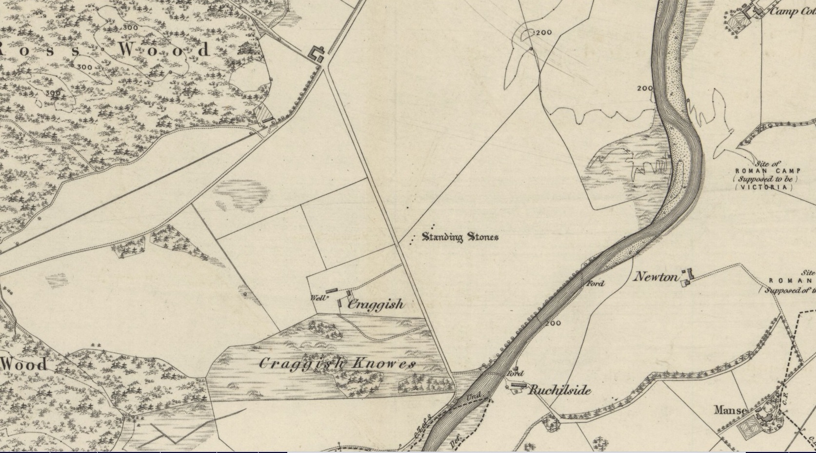
Standing Stones (destroyed): OS Grid Reference – NN 7643 2086
Archaeology & History
Site shown on 1886 OS-map
Highlighted on the 1866 OS-map was an impressive cluster of standing stones that sadly met their demise sometime around at the end of the 19th century. They were mentioned to “still exist” when the local writer Samuel Carment passed them in 1882, but had been destroyed by the time the Ordnance Survey lads resurveyed here in 1899. Altogether there were at least six of them, standing aligned sharply northeast-southwest and were described in one of Fred Coles’ (1911) essays, who lamented their passing. Listed in the stone row surveys by Burl (1993) and Thom (1990), the prime description we have of them was by Cole himself, who told:
“This site has also been wantonly bereft of its group of megaliths. Up to so recent a date as 1891 there were several. These were shown on the (Ordnance Survey map) as three in one line and two in another, on a field about one furlong NE of Craggish farmhouse, close to the road coming down from Ross, and nearly a quarter-mile NW of the ford across the Ruchil at Ruchilside.”
In Finlayson’s (2010) colourful survey of the local megaliths he told that the stones,
“Stood, by the road, in what is now ‘The Whinney Strip’: a boulder-strewn strip of land 20m wide dividing up otherwise flat and even grazing land.”
References:
Burl, Aubrey, From Carnac to Callanish, Yale University Press 1993.
Cole, Fred, “Report on Stone Circles Surveyed in Perthshire, Principally Strathearn,” in Proceedings of the Society of Antiquaries, Scotland, volume 45, 1911.
Thom, A., Thom, A.S. & Burl, Aubrey, Stone Rows and Standing Stones – 2 volumes, BAR: Oxford 1990.
Acknowledgments: Big thanks for use of the early edition OS-map in this site profile, Reproduced with the kind permission of the National Library of Scotland.
Take the B824 road that runs between Dunblane and Doune and, whichever direction you’re coming from, watch out for the large statue of David Stirling by the roadside (y’ can’t really miss it!). Stop here. Then, walk along the dirt-track into the field by the side of the statue, keeping your eyes peeled 50 yards along, for the upright stones in the field on your right, at the top of the brow of the hill.
Archaeology & History
Glenhead Farm standing stones
A few hundred yards south of the large Glenhead Standing Stone, we come across this curious small row of three reasonably large standing stones which — the more you look at them — give the distinct impression that they may be the remains of a large prehistoric tomb. But archaeology records are silent on this matter and we must contend with what we can see. At the northernmost end of the row, a fourth stone lays amongst the vegetation: it may have once stood alone, or maybe been snapped from its fellow monolith. 20 yards south is a large mass of stone; perhaps from an old building, perhaps cairn spoil (does anyone know?)
The local historian Moray Mackay (1984) thought that the line of stones here were once a part of something larger, saying:
“Originally it was probably a circle of six stones, with a seventh in the middle, and this central stone can still be identified by its flat top on which are the mysterious and well known cup-marks, much weathered but plainly visible. Close to the site, urns and stone hammers were unearthed last century.”
Glenhead stone row, looking north
Of the three remaining upright stones, it is the central one which has the cup-markings visible on its top and side (Allen 1882), with a lovely covering of almost luminous lichen giving it extra effect! (a separate TNA Site Entry for the cup-marked stone will be written in due course)
The famous astroarchaeologist Alexander Thom and his son (1990) described the place as,
“A three stone alignment showing about 33° N declination in one direction and 31° S in the other, but the azimuth comes from the stones only and so cannot be accurate. Perhaps the line is lunar to the hill in the SW…”
In Thom’s (1967) earlier work he posited that the alignment may relate to the rising of the star Capella around 1760 BC, but this is untrue. Thom’s error however, was not of his making, but due to the false dates that archaeologists ascribed to megalithic ruins at the time – dates which Thom used in his research, believing that the archaeological fraternity would know what they were talking about! In their collaborated text, Aubrey Burl added how,
“these stones stand on a hill summit at 360ft (110m) OD. The row is on a north-facing slope. Three stones stand. A fourth, prostrate, 6ft 6 in (2m) long, lies against the NE pillar. The row has a NNE-SSW axis. The northernmost stone is 3ft 6in high, the centre 4ft, and the SSW, characteristically the tallest, 6ft 6in… The line is about 27 feet (8.3m) long. The central stone has 23 cupmarks on its top and 4 more on its western side.”
…to be continued…
References:
Allen, J. Romilly, “Notes on some Undescribed Stones with some Cup-Markings in Scotland,” in PSAS 16, 1882.
Burl, Aubrey, From Carnac to Callanish, Yale University Press 1993.
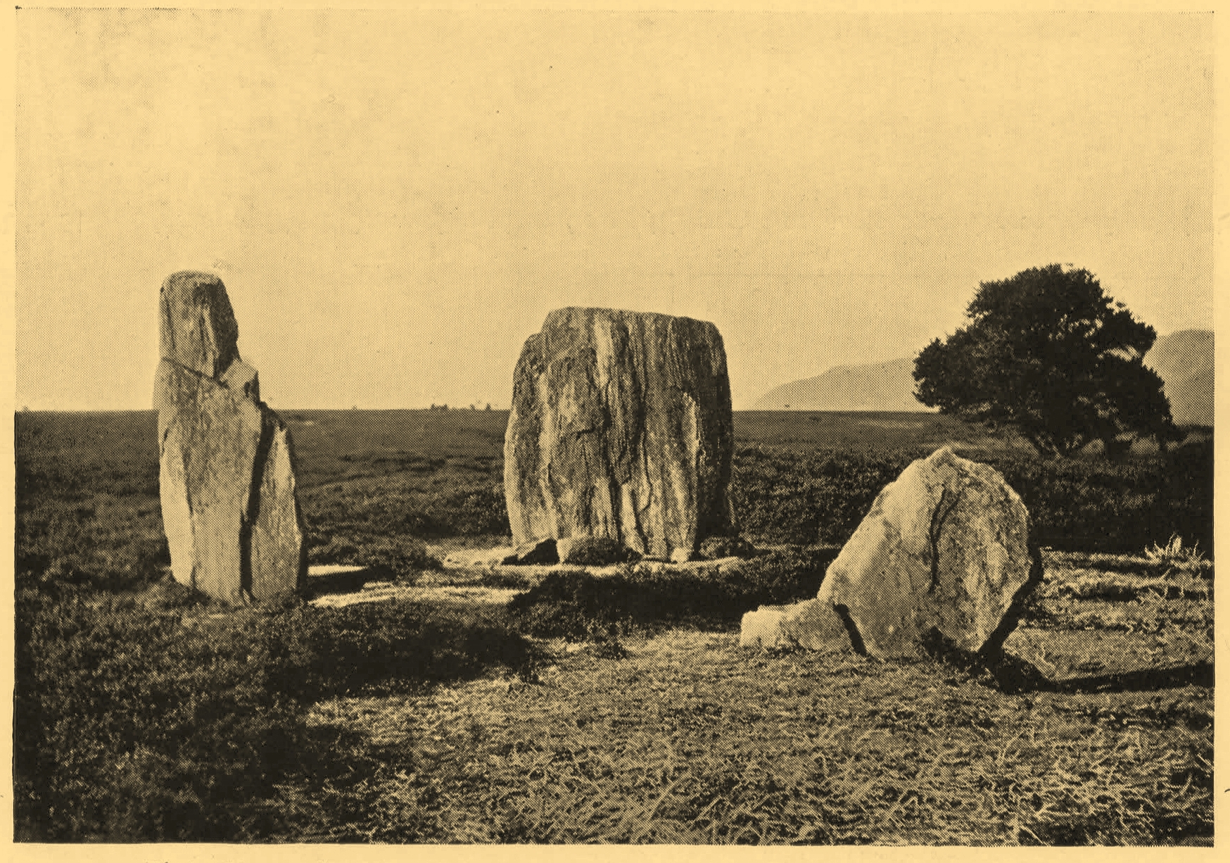
This is an impressive and well-known megalithic stone row, found just 4-5 miles inland from the coastal town of Fishguard. The drawing here is used courtesy of Elizabeth Haines, landscape artist, and gives a fine representation of the site as I’m sure you’d agree! Consisting of at least eight standing stones — four still upright and four laid down — aligning northwest to southeast, the tallest stone stands at the southerly end measuring 11 feet tall. The stone row is found in a region rich in prehistoric remains. Aubrey Burl (1993) said of the place:
“Four of the eight stones in this unusual row still stand, trapped in a field-wall, tow of them now gateposts. Thom suggested that the line, 131ft (40m) long, was laid out downhill towards the WNW and the minor northern moonset just north of Mount Leinster ninety-one miles away across the Irish Sea.”
Quite a distance! And perhaps because of this, Burl thought that the nature of this line of stones was more archaeological than astronomical, with its focal point being more likely up the slope to the ESE instead.
Folklore
There was once an adjacent chambered tomb here which, when it was “destroyed for a house in 1844 brought the owner no luck” (Thom, Thom & Burl 1990) – which is damn good to hear! There was a piece of folklore mentioned by E.L. Barnwell (1868) and other writers that the fields here marked the fall of three Welsh princes in the Battle of Mynydd Carn in 1084. In Roger Worsley’s (1988) fine tour of Pembrokeshire’s historical sites, he tells how these megaliths in the “field of the dead” are also haunted, saying:
“A local tale tells of Ladi Wen, a ghostly White Lady wandering about the fields at night, and who will kill anyone who ventures near; it was enough to keep villagers away from the site well into this century, though the stone row is over five thousand years old.”
References:
Barber, Chris & Williams, John Godfrey, The Ancient Stones of Wales, Blorenge: Abergavenny 1989.
Barnwell, E.L., “Alignments in Wales,” in Archaeologia Cambrensis, volume 14, 1868.
Burl, Aubrey, From Carnac to Callanish, Yale University Press 1993.
Thom, Alexander, Thom, A.S. & Burl, Aubrey, Stone Rows and Standing Stones, BAR 560: Oxford 1990.
Worsley, Roger, The Pembrokeshire Explorer, CCP: Abercastle 1988.
This site hasn’t been located. However, if it hasn’t been destroyed by the quarrying on the SW side of the moor, remains of it should still be found amidst the heather and would be a good discovery for any enthusiast.
Archaeology & History
The first notes I found about this place were those by archaeologist Sydney Jackson in 1956, who wrote:
“It would be interesting to know what Dr Richard Richardson, of Bierley Hall, Bradford meant when, writing about 1709, he said that Mr Benjamin Ferrand show him a ‘skirt of stones’ on Harden Moor, near to a row of stones placed in a line nigh two hundred paces in length some two feet above the heath, others hidden beneath it.” (my italics)
The undoubted man-made nature of this row of stones was emphasized by Dr Richardson when he wrote,
“That these stones were placed here by design, no person can doubt; but for what I end cannot conjecture, having never seen anything of this kind before.”
The great Yorkshire historian Harry Speight (1898) also came across the same antiquarian notes many years before and speculated how,
“it may be inferred from this that it had been a double row of stones, like the avenue of Maiden Castle in Swaledale.”
The ‘skirt of stones’ that were described here may be the well-preserved Harden Moor Circle. However in recently finding the short essay of Peter Craik (1907) of Keighley, this idea may need re-assessing, as Craik clearly shows in his survey of the the nearby Catstones Ring earthwork, what he described as the “remains of a cairn” on the northern edge of that ring, giving us a different location for this lost stone row.
However, another potential position for our lost stone row that needs exploring is the one described by Butler Wood following an exploratory visit here with the Bradford historian, William E. Preston, at the beginning of the 20th century. Mr Wood (1905) told of them both coming across some sort of earth-and-stone line “half-a-mile north of” the Catstones Ring, telling:
“Mr W.E. Preston and myself traced a short time ago on Harden Moor, remains of an entrenchment for a distance of 80 or 90 yards. It faces south, and lies near Spring Head Heights. The wall consisting of boulder and earth rising three feet above the soil, but there is no trace of a ditch.”
This is obviously half the length described by Richardson and Ferrand in 1709, but nearly two centuries separate the two accounts (the position of Mr Woods’ line is roughly SE 072 387; whilst that nearer to the Catstones Ring would be nearer SE 069 383).
I’ve searched the tops of this moorland a number of times hoping to locate this seemingly important megalithic stone row, obviously without success. Further searches on the moor are needed after the heather’s been burnt back.
Get to the Twelve Apostles stone circle, then walk just 100 yards down the main footpath south, towards Bingley, and watch out for a small footpath immediately to your left. Walk on here and head for the rocky outcrop a half-mile ahead of you. Once past the outcrop, take the first footpath right and walk down for another 100 yards. Stop! – and walk into the heather. The circle’s about 50 yards away! You can of course come from the Menston side of the moor, following the same directions for the Great Skirtful of Stones, but keep walking on for another 200 yards, towards the rocky outcrop again, turning left down the path for 100 yards, before stopping and walking 50 yards into the heath again!
Archaeology & History
Roms Law circle
This is one of my favourite sites on these moors. I’m not 100% sure why – but there’s always been something a bit odd about the place. And I don’t quite know what I mean, exactly, when I say “odd.” There’s just something about it… But it’s probably just me. Though I assume that me sleeping rough here numerous times in the past might have summat to do with it, playing with the lizards, and of course…the sheep… AHEM!!! Soz about that – let’s just get back to what’s known about the place!
Grubstones is an intriguing place and, I recommend, recovers its original name of Roms or Rums Law. It was described as such in the earliest records and only seems to have acquired the title ‘Grubstones’ following the Ordnance Survey assessment in the 1850s. The name derives from two compound words, rum, ‘room, space, an open space, a clearing’; and hlaw, a ‘tumulus, or hill’ – literally meaning here the ‘clearing or place of the dead,’ or variations thereof. But an additional variant on the word law also needs consideration here, as it can also be used to mean a ‘moot or meeting place’; and considering that local folklore, aswell as local boundary records tell of this site being one of the gathering places, here is the distinct possibility of it possessing another meaning: literally, ‘a meeting place of the dead’, or variations on this theme.
The present title of Grubstones was a mistranslation of local dialect by the Ordnance Survey recorders, misconstruing the guttural speaking of Rum stones as ‘grub stones.’ If you wanna try it yourself, talk in old Yorkshire tone, then imagine some Oxford or London dood coming along and asking us the name of the ring of stones! It works – believe me….
The site has little visual appeal, almost always overgrown with heather, but its history is considerable for such a small and insignificant-looking site. First described in land records of 1273 CE, Roms Law was one of the sites listed in the local boundary perambulations records which was enacted each year on Rogation Day (movable feast day in Spring). However in 1733 there was a local boundary dispute which, despite the evidence of written history, proclaimed the Roms Law circle to be beyond the manor of Hawksworth, in which it had always resided. But the boundary was changed – and local people thenceforth made their way to the Great Skirtful of Stones on their annual ritual walk: a giant cairn several hundred yards east to which, archaeologically, there is some considerable relationship. For at the northern edge of the Roms Law circle is the denuded remnants of a prehistoric trackway in parts marked out with fallen standing stones and which leads to the very edge of the great cairn. This trackway or avenue, like that at Avebury (though not as big), consists of “male” and “female” stones and begins – as far as modern observations can tell – several hundred yards to the west, close to a peculiar morass of rocks and a seeming man-made embankment (which I can’t make head or tail of it!). From here it goes past Roms Law and continues east towards the Great Skirtful, until it veers slightly round the southern side of the huge old tomb, then keeps going eastwards again into the remnants of a prehistoric graveyard close by.
In my opinion, it is very likely that this trackway was an avenue along which our ancestors carried their dead. Equally probable, the Roms Law Circle was where the body of the deceased was rested, or a ritual of some form occurred, before taken on its way to wherever. It seems very probable that this avenue had a ceremonial aspect of some form attached to it. However, due to the lack of decent archaeological attention, this assertion is difficult to prove.
A previously unrecognised small single tomb is in evidence to the immediate southeast (5 yards) of the circle. There is also another previously unrecognised prehistoric trackway that runs up along the eastern side of the circle, roughly north-south, making its way here from Hawksworth Moor to the south. The old legend that Roms Law was a meeting place may relate to it being a site where the dead were rested, along with it being an important point along the old boundary line. Records tell us that the chant, “This is Rumbles Law” occurred here at the end of the perambulation – which, after the boundary change, was uttered at the Great Skirtful. This continued till at least 1901.
Northern section of the Ring
Modern archaeological analysis of the site is undecided as regards the actual nature of Roms Law. Ordnance Survey maps show it as an “enclosure” (which is vague); Faull & Moorhouse’s survey (1981) erroneously tell us it had no funerary nature, contrary to Eric Cowling’s (1946) report of finding bones and ashes from the small hole in near the centre of the ring, aswell as the 1880 drawing of the site in Collyer & Turner’s survey (above). And we find the single cairn on the south-eastern edge of the ring indicating burial rites of sorts definitely occurred here. Described variously by previous archaeologists as a stone circle, a ring cairn, cairn circle, an enclosure, aswell as “a rubble-fill wall of a circular house” (by some anonymous member of the West Yorkshire Archaeology Service, who didn’t respond to my queries about this curious assumption), the real nature of Roms Law leans more to a cairn circle site. A fine example of a cup-and-ring stone — the Comet Stone — was found very close to the circle, somewhere along the Grubstones Ridge more than a hundred years ago, and it may have had some relevance to Roms Law.
This denuded ring of stones is a place that has to be seen quite blatantly in a much wider context, with other outlying sites having considerable relationship to it. Simple as! (If you wanna know more about this, check out my short work, Roms Law, due out shortly!)
Describing the status and dimensions here, our great Yorkshire historian Arthur Raistrick (1929) told that:
“The larger stones still standing number about twenty, but the spaces between them are filled with stones of many intermediate sizes, so that one could with only considerable detail of size, etc, number the original peristalith.”
…Meaning that we’re unsure exactly how many stones stood in the ring when it was first built! Although a little wider, the Roms Law is similar in form to the newly discovered ‘Hazell Circle‘ not far from here. The site has changed little since Raistrick’s survey, though some halfwits nicked some of the stones on the southwestern edge of the site in the 1960s to build a stupid effing grouse-butt, from which to shoot the birds up here! (would the local council or local archaeologist have been consulted about such destruction by building the grouse-butt here? – anyone know?) Thankfully, this has all but disappeared and the moorland has taken it back to Earth.
There is still a lot more to be told of Roms Law and its relationship with a number of uncatalogued sites scattered hereby. Although it’s only a small scruffy-looking thing (a bit like misself!), its archaeology and mythic history is very rich indeed. “Watch This Space” – as they say!
Folklore
Alleged to be haunted, this site has been used by authentic ritual magickians in bygone years. It was described by Collyer & Turner (1885) “to have been a Council or Moot Assembly place” — and we find this confirmed to a great extent via the township perambulation records. Considerable evidence points to an early masonic group convening here in medieval times and we are certain from historical records that members of the legendary Grand Lodge of All England (said to be ordained in the tenth century by King Athelstan) met here, or at the adjacent Great Skirtful of Stones giant cairn 400 yards east.
The boundary perambulations which occurred here on Rogation Day relate to events just before or around Beltane, Mayday. Elizabeth Wright (1913) said of this date:
“These days are marked in the popular mind by the ancient and well-known custom of beating the parish bounds, whence arose the now obsolete name of Gang-days, and the name Rammalation-day, i.e., perambulation-day, for Rogation-Monday. The practice is also called Processioning and Possessioning… The reason why this perambulation of the parish boundaries takes place at Rogationtide seems to be that originally it was a purely religious observance, a procession of priest and people through the fields to pray for a fruitful Spring-time and harvest. In the course of time the secular object of familiarizing the growing generation with their parish landmarks gained the upper hand, but the date remained as testimony to the primary devotional character of the custom.”
And the calling of, “This is Rumbles Law” maintained this ancient custom when it used to be uttered here.
“One of the great level Highland moors stretches away beneath the eye, like a dark waveless lake, contrasting with the distant heights, among which Ben Lawers rears its pyramidal summit to an elevation of upwards of 4000 feet above the level of the sea. Amid this wild Highland landscape the huge standing stones, grey with the moss of ages, produce a singularly grand and imposing effect; and from the idea of lofty height which the distant mountains suggest, they convey a stronger impression of gigantic proportions than is produced even by the first sight of the giant monoliths of Salisbury Plain.”

 I think it’s likely that there would have been more prehistoric sites in the vicinity, but a notable oddity is the almost complete absence of other recorded sites anywhere nearby. Of course, if there was anything, those thoughtful Forestry Commission heads would have destroyed it. We are left, simply, with the old but reliable notes of Messrs Dixon (1923) and Mitchell (1925) who told that, in their days, other remains did exist nearby in the form of ancient cairns and hut circles—‘Pictish’ according to tradition. If we’re lucky, some damaged parts of them might still be found at the edges, a short distance to the north west…
“on the highest part of the moorland…is a group of ‘clachan iobairt’, or stones of worship, where the Druids of old performed their mysterious rites, going round the circle of standing stones from east to west with the sun, or the ‘car deasal’, the lucky side, when they wished to invoke a blessing upon their friends, and going round the circle in the opposite direction, from west to east, the ‘car tuathsel’, or unlucky side, when they wished to pronounce a curse upon their foes.”


")