In the lovely village that is the Crook of Devon, go down Church Lane, past the houses, until you meet with the dirt-track on your left that runs straight up beneath a grove of trees heading into the green fields. Go up here 100 yards until you meet another track that goes sharp left. Just here, 10 yards along, a solitary tree sits by the wall; and just past it is a large boulder up against the walling. This is the Bull Stone!
Archaeology & History
Bull Stone, Crook of Devon
If you didn’t know owt about this place, you wouldn’t even give it a second-thought. A decent-sized rock, obviously broken-up and then plastered back together again, is innocuously resting up against the wall. But it appears to have had some significance in bygone centuries, although its full story has yet to be recovered. It was described in the Royal Commission (1933) report for antiquities, where they told:
“Built against the dike on the north side of an old roadway, half a mile to the south of Crook of Devon, is a huge sandstone boulder known as ‘The Bull Stone.’ It is probably an old boundary mark or, like the Leslie Stone…it may have some association with the old-time pastime of bull-baiting. The stone was broken up a number of years ago, and the fragments were carted away to be built up in another dike hard by, but, in response to public agitation, they were returned to the original site and cemented together. The boulder rises 3½ feet above ground and has a girth of about 13 feet at the base. It is not set up vertically, but lies on its side.”
It may originally have been a standing stone as local lore tells that it once stood as high as a grown man, but is now only half that size. It may have been one of the meeting places of the legendary witches at the Crook of Devon, but this is guesswork on my behalf (so best ignored!).
References:
Royal Commission on the Ancient & Historical Monuments of Scotland, Fife, Kinross and Clackmannan, HMSO: Edinburgh 1933.
One helluva climb to reach this little fella. I simply started at Dalgirdy cottage, some 5 miles along Glen Lochay, on the right-hand side of the road. Then, walk right up the burnside, all the way up until it begins to level out and the old shielings appear. When you’ve got to where they just about finish, about 50-70 yards on the east side of the burn, you’ll see the small stone standing upright, all alone. You can’t really miss it!
Archaeology & History
Allt Ghaordaidh, looking south-ish!
No previous written records exist that describe this small standing stone, whose nature and age may be akin to that at nearby Tirai, found amidst the derelict village a couple of miles east, lower down the slopes — i.e., it may have simply been part of some of the ancient village remains and shielings found close by, either side of the rushing burn. But whether it’s only medieval or much more ancient than that, its position in the landscape alone (much like Tirai’s uprights), deserves to be known about.
There are considerable amounts of ancient remains scattering the mountains slopes all round here: some have been catalogued, but a lot of it has not. This little standing stone is at last alive again! (take good food and kit when visiting here)
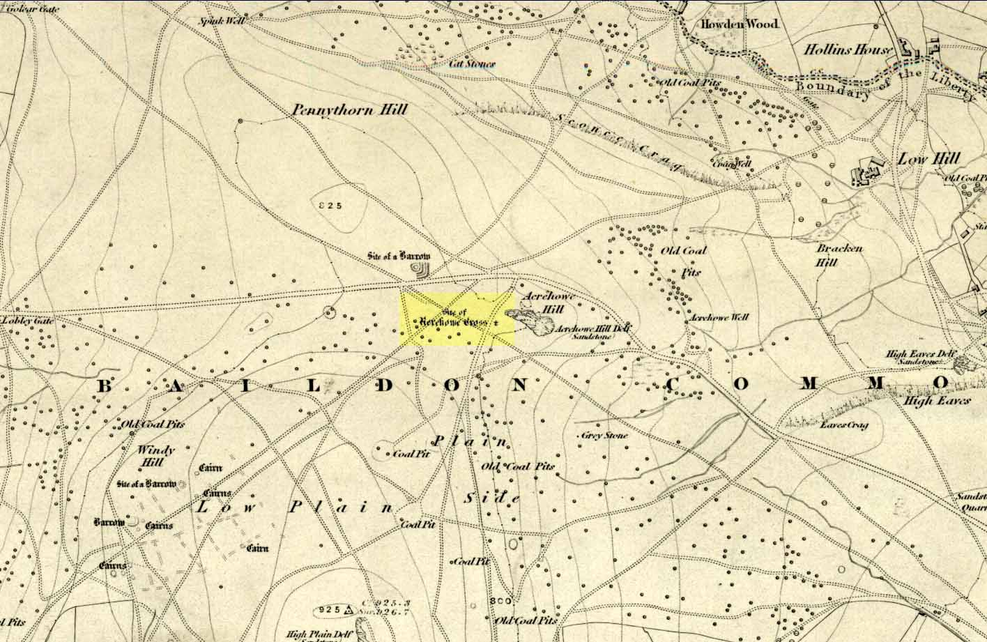
Once found on the other side of the road from the prehistoric circle of Acrehowe Hill, this old cross was destroyed sometime in the first half of the 19th century by one of the stewards to the Lady of the Manor of Baildon, a Mr Walker. It’s unlikely that Mr Walker would have performed this act without direct orders from the Lady of the Manor, so the destruction should really be laid at the feet of the land-owner, who’ve got a habit of destroying archaeological sites up and down the land, even today.
Found near the crown of a small hill on the horizon whether you’re coming from Eldwick- or Baildon-side, the cross was erected (probably between the 12th and 14th centuries) amidst a cluster of heathen burials and cup-and-rings, many of which would have been known by local peasants as having old lore or superstitions about them. So the church commandeered this spot, desacralized it and no doubt enacted profane rites around it under the auspice of some spurious christian law. They did that sorta thing with every non-christian site they ever came across—or simply vandalised it, much as many of them still do today. Sadly we know not the exact history of the old cross: whether it was an old standing stone on the crown of this hill which they defaced and made into a cross, or whether they erected their own monument, we’ll never know. But the idea of a once-proud monolith standing here is a strong possibility, considering its position in the landscape and the stone rings of Pennythorn and Acrehowe close by (cup-and-ring stones such as carving no.184 are also close by).
The cross itself once gained an additional incorrect title by the cartographers of the period, who named it Rerehowe Cross—but this was simply a spelling mistake and its newly-found title didn’t last long. The local industrial historian William Cudworth (1876) described the lost cross in his large work, where he told that,
“many of the inhabitants can remember and point out the exact spot where it stood, and no doubt could find some of the stones of which it was composed. It was destroyed by one of the overseers and a large portion of it used for fence stones.”
Harry Speight (a.k.a. ‘Johnnie Gray’) and others also mentioned the passing of this old stone, but give no additional information.
Folklore
In William Cudworth’s description of this site he told how “the village tradition is that it was put up in commemoration of a great battle that was fought on the Moor” at Baildon; but W.P. Baildon (1913) thought this was unlikely. Instead, he cited an 1848 Name Book reference dug out by W.E. Preston, which told that on the summit of Acrehowe Hill,
“Here stood a cross which, according to traditional evidence was erected at the period that markets were held at Baildon, in consequence of a plague which prevented the country people from visiting the village with provisions, etc. The site of its base is very apparent, being circular, about 8 feet in diameter. A large flag stone with the stump of the cross remaining in its centre, was pulled up and destroyed by Mr Walker (Baildon Hall) a few years since.”
References:
Baildon, W. Paley, Baildon and the Baildons (parts 1-15), St. Catherines: Adelphi 1913-26.
Bennett, Paul, The Old Stones of Elmet, Capall Bann: Milverton 2001.
Colls, J.M.N., ‘Letter upon some Early Remains Discovered in Yorkshire,’ in Archaeologia, volume 31, 1846.
Cudworth, William, Round about Bradford, Thomas Brear: Bradford 1876.
Gray, Johnnie, Through Airedale from Goole to Malham, Walker & Laycock: Leeds 1891.
From the famous Dick Hudson’s pub on the south side of Ilkley Moor, take the road right (east) for a half-mile until you reach the large Weecher Reservoir just off the roadside on your right. Less than 300 yards past the reservoir, a footpath takes you onto the moor itself. Walk up the path for about ⅔-mile — crossing one wall, then walking roughly parallel with another on your right — until you reach a crossing of paths where there are 2 gates or stiles. Take the lower of the two stiles, through the wall, but below the fence. You’ll see an awful Yorkshire Water cover, which has just about destroyed the once-fine well that had always flowed here. Below this, by the wallside, are the trickling remains of our old healing spring.
Archaeology & History
When I was a young boy, Horncliffe Well was the site we would visit every weekend as our first stopping-spot on our regular ventures exploring these moorlands — “from Wrose to Rombalds,” as we use to call it! The old well was always very plentiful, strong-flowing, cold and truly refreshing. It was undoubtedly the best water source on the entire Rombalds Moor region, never drying up. Even in the great droughts of 1976 and 1995, after all others had just about failed, the waters at Horncliffe were still flowing as strong as ever, as they had always done. But not anymore…
Edna Whelan’s old drawing
First described in land records of 1273 CE, this has always been a well of great repute and oral tradition told that this great old well never ran dry. It marked the ancient boundary point where the moorlands of Hawksworth, Burley and Bingley all meet. By name alone it is associated with the nearby and curious Horncliffe Circle, whose status itself is unclear (the circle seems more a place of refuge or living than a true ritual site).
Horncliffe House around 1801
The remains of old buildings on the flat just above where the waters once flowed were built in much more recent centuries. The building appears to have been started around 1799, for E.E. Dodds (1985) told that in 1800 it was used as a school for several years by local teacher Joshua Briggs. J. Horsfall Turner (1907) published a copy of an old drawing of the school, as it was soon after construction.
Horncliffe Well was dug into by the privatized water company known as Yorkshire Water (owned by rich greedy fuckers) in the 1990s, who channelled most of its endless supply away for commercial benefit. When their company was stealing the water from the moors, the workmen snapped an old markstone at its base next to the adjacent Horncliffe House (in ruins). The waters had always flowed fast and freely, but after Yorkshire Water had finished their ‘work’ here, the great majority of Horncliffe’s water supply subsided considerably, leaving walkers, birds and animals to suffer from its demise. In all sincerity, it’s to be hoped that good people someday will visit this once-fine site and return it to its previous healthy status.
Folklore
When we were kids we came here every weekend and got to know the old ranger who we’d meet either here or at the adjacent Horncliffe Circle, 250 yards NNE, where we’d sit and eat. In the mid-1970s, he told us that the old well was once a site where the fairy-folk would play, around Mayday (beltane). And though in later years I’ve sought for any information about this in all early antiquarian books that cover this area, I’ve never found any mention of this tale in print. The old ranger knew the moors and its history better than anyone I’ve ever known and many old stories died with him after his death.
References:
Bennett, Paul, The Old Stones of Elmet, Capall Bann: Chieveley 2003.
Dodd, E.E., Bingley: A Yorkshire Town through Nine Centuries, M.T.D. Rigg: Guiseley 1985.
Laurence, Alastair, A History of Menston and Hawksworth, Smith Settle: Otley 1991.
Turner, J. Horsfall, Idle Upper Chapel Burial Registers and Graveyard Inscriptions, Harrison & Son: Bingley 1907.
Whelan, Edna, The Magic and Mystery of Holy Wells, Capall Bann: Chieveley 2001.
Whelan, Edna & Taylor, Ian, Yorkshire Holy Wells and Sacred Springs, Northern Lights: Dunnington 1989.
On the A657 road, a half-mile past Greengates towards Calverley, just before the road starts going uphill, take the lower dirt-track of Eleanor Drive on your left into Calverley Woods (here known as West Woods). About 150 yards along the track, note the small footpath on the right which goes up diagonally further into the trees. Go along here until you reach the remains of a dried-up pond on your left. The carved stone is about 10 yards before the pond, just above the footpath.
Archaeology & History
Rubbing of the 2 cupmarks
Another stone only for the puritans amongst you! This (and the West Woods 2 carving) was one we found in 1985 when we were exploring the woods looking for the Calverley Woods cup-marked stone reported by Sid Jackson in the 1950s. The stone is a small roughly oblong, earthfast rock, about 2ft by 1ft across, and has two distinct but faded cup-marks on its slightly sloping face. That’s it!
Soon after first finding this, we made a couple or rubbings of the stone, one of which I reproduce here and which shows the two cup-marks. You’ll note the measurement and note of the cups being 2 megalithic inches (MI) in diameter. The MI was a statistical unit of measure suggested by the late great Alexander Thom, who found regular integers of 2.07cm in many of the cup-and-rings he examined, and so surmised it as a deliberate numeric system. At the time when we found this cup-marked stone, I was exploring Thom’s idea and was very much taken up with it. However, after a few years doings numerous rubbings of the many cup-and-ring stones in West Yorkshire, and exploring the simple size of the human hand and how we execute cup-markings on rocks, I found Thom’s idea didn’t seem to be realistic. (though I still love Thom’s works: the man was an outstanding researcher, far exceeding all the archaeologists of his period in terms of his exploratory methods)
References:
Bennett, Paul, “The Undiscovered Old Stones of Calverley Woods,” in Earth 2, 1986.
Dead easy! Just about in the middle of the village, by the side of the road where a seat allows the weary walker a chance to sit and rest, the Tarry Stone stands before it, with a plaque on the wall above the seat. The old postcard here shows its situation clear enough!
Archaeology & History
The history of this large rock near the middle of Cookham village is important in the history of the old village, though there is no direct evidence to give it a prehistoric pedigree. It was known to be an ancient boundary stone and is included in perambulation records of the area, where local people would annually walk and redefine the landscape of Cookham: a pastime known across the land, but which fell into disuse in Victorian times. Such perambulations are thought to trace way back into the mythic lands of prehistory — so the Tarry Stone here may well have an archaic provenance.
The known history of the stone was gathered and described in Stephen Darby’s (1899) rare work on the place-name history of Cookham. He wrote:
“A stone 3½ ft high, by 4 ft long, and 2½ ft thick. This formerly stood in Cookham village, about two feet from Dodson’s fence, where the roads parted to the church and the ferry. It is now in the Mill Garden at Cookham, where it was removed by the late George Venables when he was church-warden. This stone was formerly known as Cookham Stone.
“A.D. 1506: The tithing man presents that the Warrener ought to hold sports at Cookham Stone on the day of Assumption; and he has not done so (Cookham Manor Court Rolls).
“The stone was originally a boundary stone to the property of the Abbot of Cirencester, whose house was close by, as is shown in the will of John Luffenham, A.D. 1423.”
An old plaque that was once attached to the rock told, “The Tarry Stone at which sports were held before 1507 AD, stood formerly 50 yards NNE and was replaced here AD 1909 by order of the parish council.” The position described “50 yards away” was next to an old pub with the fascinating legendary name of ‘Bel and the Old Dragon’!
Folklore
Dennis Curran’s 1976 drawing
One of the main reasons this site has been included here is the legendary attachments. When the stone was moved from its original position in 1839 by a certain George Venables, to nearby Mill House Gardens, local people told how the Venable family thereafter were cursed. It was thereafter moved back to its earlier site!
The stone has been suggested as a meteorite — a theme that was echoed in Peter Ackroyd’s Thames (2007), but the Tarry Stone is a regional sarsen rock, albeit peppered with erosion holes, giving a more ‘foreign’ look to it!
Cookham was also the village where the spirit of the god Herne “winds his horn and the music of his hounds can be heard from across the common.” (Yarrow 1974) The stone was also the focal point of village games in earlier centuries.
References:
Ackroyd, Peter, The Thames: Sacred River, Chatto & Windus: London 2007.
Darby, Stephen, Place and Field-Names of Cookham, Berkshire, privately printed: London 1899.
Hallam, Elizabeth, Domesday Heritage, Arrow: London 1986.
Triangulation & cairn atop of Rye Loaf Hill on a truly foggy eve
Best way is to take the Settle to Kirkby Malham road: a tiny little thing running steep from Settle up and around the hills, making sure you don’t miss the turn-off to Kirkby and head down to Airton instead. About 100 yards along from the road-junction to Kirkby, there’s a small copse of trees and a gate just before it. Walk up through that and head right to the top of the nice hill a mile or so ahead of you to the north. It can be boggy, slippy and well good! A decent Barmy Bennett expedition this way lies! Get to the top of the hill and you can’t miss the cairn!
Archaeology & History
First shown on the 1771 Greenwood map, this is another intriguing little-known antiquity in our Yorkshire hills. It’s intriguing as the precise age and nature of the site doesn’t appear to have been ascertained. On top of this lovely rounded hill is not only a stunning view for many miles in all directions (unless you climb it on a very cloudy foggy day, like we did!), but the rock-pile which someone in recent years has turned into a wind-break has been taken from a much larger, and much older rock-pile on the very summit.
The cairn stands about a yard tall at the highest and measures roughly 12 yards in diameter, but the edges of the site seem to disappear further beneath the peat and vegetation on the hilltop. A section in the middle of the cairn has obviously been dug into, probably to create the stone shelter on its southern side, but it also gives the impression of having been dug into by treasure-seekers in the past — similar to the trenches found in the Snowden Crags cairn circle, the Great Skirtful of Stones and other prehistoric tombs.
The site has been marked on Ordnance Survey maps as a simple marker cairn (non-antiquated writing on the maps), but I have strong suspicions after visiting this peak that the cairn in question is a lot older than has previously been assumed. So I contacted local archaeologist Robert White and asked if he knew of any archaeological data about the cairn, but he said there was nothing that he knew. However, an additional piece of information that adds potential to the antiquity of the cairn came from the awesome pen of Harry Speight (1895) who told that,
“The original name of this eminence is Inglehow, which suggests like Ingleborough and ancient look-out post or beacon hill.”
The suffix how or howe is well-known to place-name students in northern England and beyond as a burial mound or tumulus. We must be cautious however, for as Gelling (1988) says, the word “is frequently applied to a tumulus, but it can refer to a natural hill.” But Speight’s idea that the name may have had something to do with beacons was mentioned — albeit without reference to Rye Loaf Hill, whose history and features he ignored — in Thomas Whitaker’s (1878) huge survey, where he wrote:
“In this parish was an immemorial custom, continued within the memory of many persons yet alive, of kindling fires on the tops of the surrounding hills on St. Laurence’s Eve, the 9th of August. This night was called the Kennel or Kennelk night; and the tradition of the place is, that the fires were intended as a memorial of the beacons kindled by the Saxons to alarm their countrymen on the sudden approach of the Danes.”
The parish in question that Whitaker described was Giggleswick, which is right next door to Settle, in whose parish Rye Loaf Hill lives.
On the southern edge of Rye Loaf are a couple of other archaeological place-names that need looking at. We have a couple of ‘Stone Haws’, which are probably cairns, close to which we find extensive evidence of human activity at some time in the past. But close to one of these piles of stones is another, far more fabled rock whose history appears to have long since been neglected: the Dragon Stone of Scosthrop Moor. Never heard of it? That’s not surprising…
References:
Gelling, Margaret, Signposts to the Past, Phillimore: Chichester 1988.
Smith, A.H., English Place-Name Elements – volume 1, Cambridge University Press 1956.
Speight, Harry, Tramps and Drives in the Craven Highlands, Elliot Stock: London 1895.
Whitaker, Thomas Dunham, The History and Antiquities of the Deanery of Craven in the County of York, (3rd edition) Joseph Dodgson: Leeds 1878.
Carlie Craig is the tree- covered cliff, centre of photo
If you’re coming from Blairlogie, a half-mile west of the village, take the B998 road to the university, but turn right up the first road that runs uphill into the trees. But if you’re coming from Stirling or Bridge of Allan, keep your eyes peeled for the barely visible B998 at the crossroads and go up the hill, and along, for a good mile, below the Uni, past the factory, then up the small road on your left. Up this road go past the church another 100 yards and you’ll see the derelict ruins of Logie Kirk on your right. Right above the ruin you’ll see the tree-lined cliff immediately behind. This is the Carlie Craig!
Folklore
Carlie Craig on the 1862 map
The tree-covered Carlie Crags above the old ruined church and graveyard of Logie Kirk immediately below (thought to have been built in 1684) has long been associated with legends of old witches. Deriving its name from ‘carlin’, a witch or old woman (cailleach), the Crags were traditionally the place of heathen rites (authentic ones, not your plastic pagan types). In David Morris’ (1935) essay on the local township, he told the common story that “an elder in Logie Kirk was of the opinion that the Carla’ Craig…was haunted.” At the end of the 19th century, Morris remembered a local lady known as ‘Ailie’, who was said by many old folk to be the traditional “witch of Logie.”
“Sickly children were brought to her for her blessing. Occasionally people came from as far as Stirling on this errand. Her method of giving the blessing was to blow her breath on the child, and this was supposed to ward off evil. It was also said that anyone buried in Logie Kirkyard on the first day of May, Hallowe’en, or other days of that kind, without her blessing, would not rest in his grave…”
Another legend told that,
“around 1720 witches were believed to rendezvous with the Evil One (i.e. the devil) who would appear in the form of a large black dog.”
A lengthier account of the belief in witchcraft and animistic pre-christian rites above the crags was told by Charles Rogers (1853):
“About the second decade of last century, there lived in the parish of Logie several ill-favoured old women, to whom the reputation of witchcraft was confidently attached. They were believed to hold nocturnal dialogues and midnight revels with the Evil One, and Carlie Crag was regarded as one of their places of rendezvous. Satan, though he was believed to appear to them in various forms, was understood, in his interviews with the dreaded sisterhood, to appear most frequently in the aspect of a large shaggy dog, in which form it was alleged he had repeatedly been seen by the minister. An elder of the kirk had been returning of an evening from a shooting excursion among the hills, with a trusty musket, which he had picked up some years before on the field of Sheriffmuir, and discovering on the top of Carlie an animal realizing the description of the Satanic mastiff, resolved to try upon it the effects of a shot. He knelt down cautiously near the foot of the crag, and after ejaculating a short prayer, and slipping into his musket a silver coin, fired with trembling heart but steady aim. His victim, evidently shot dead, tumbled to the base, and the delighted and astonished elder lost no time in personally communicating to the minister the success of his wonderful adventure. Though not a little superstitious, the minister was somewhat sceptical as to the mysterious dog being really dead. He however agreed to accompany his elder next morning to the foot of the crag to inspect the carcase; but on reaching the spot, they found the remains of no shaggy dog or evil genius, but the lifeless form of the beautiful pet goat of a poor and aged woman, a much respected parishioner. The minister and elder both shed tears. The wicked dog still lived, the innocent goat had perished. The elder however took credit to himself for his good intentions and valorous intrepidity ; and the minister deemed it proper to improve the subject in his pulpit prelections on the following Sabbath. Discoursing on the subject of resistance to the Devil, he remarked, that the Evil One might assume numerous shapes and forms; that he went about as a roaring lion was declared in the Word, but he might take to himself various other aspects. He might even appear as a black colley dog.” But whatever form he may assume,” added the minister, ” he cannot be overcome or destroyed by powder and shot. There is a gun, however, that will shoot him, and it is this — it is the Bible. Shoot him then, every one of you, with this gun, and he shall be shot.”
Whether the vicar’s biblical superstitions were adopted by local people—who were so much more used to the living animism of landscape and natural cycles—is questionable. The crag is a fine site for ritual magick and its associative devil-lore probably derives from Pictish shamanistic practices, remains of which are evident across the Scottish hillls and northern England, where they survived for some considerable time…
References:
Morris, David, B., “Causewayhead a Hundred Years Ago”, in Transactions of the Stirling Natural History and Archaeological Society, 1935.
Roger, Charles, A Week at Bridge of Allan, Adam & Charles Black: Edinburgh 1853.
Watson, Angus, The Ochils – Placenames, History, Tradition, Perth & Kinross District Libraries 1995.
Not included in Burl’s (2000) magnum opus, it looks as if this place has long since gone – but perhaps a local or a wanderer might find remnants of it still there somewhere. The only thing I’ve so far found about it is in Martin Martin’s journey here in 1695, where he described this “stone circle in the sea” thus:
“On the east-side of the village Rowdil, there is a circle of stone, within 8 yards of the shore: it is about 3 fathoms under water, and about 2 stories high: it is in form broader above than below, like to the lower story of a kiln: I saw it perfectly on one side, but the season being then windy, hindered me from a full view of it. The natives say that there is such another circle of less compass in the Pool Borodil, on the other side of the bay.”
Local people say that the structure is a natural one, with others of a similar nature found close by. Does anyone know more about this – and perhaps about the other apparent circle at Borasdal, less than a mile to the west?
References:
Martin, Martin, A Description of the Western Islands of Scotland in 1695, Eneas Mackay: Stirling 1934.
From Mytholmroyd, go up the Cragg Vale Road, then 2 miles up take the road steep on your right down and round St. John’s Church, then keep going along the road up to Withens. About a mile up, a road turns sharply right. Go up here for a few hundred yards, past the trees, and 100 yards on the road splits in a ‘V’. Stop here. Go into the field on your left which slopes downhill and less than 100 yards down you’ll see the large long stone laid in the grass. That’s it!
Archaeology & History
The fallen stone, with Teddy! (image courtesy ‘QDanT’)
Included in the Addenda of The Old Stones of Elmet (p.222), here is a recumbent monolith more than 8 feet long and 6 feet across which really needs to be resurrected as it would be an impressive sight! Found halfway up Withens Clough, a local land-owner told me it was one in a row of several such stones, though no trace of the others can be found. Found in the appropriately called Standing Stone Fields, it was last shown on the 1850 OS-map, as the attached illustration shows and is positioned just above the “S” of the smaller highlighted “standing stone”, just where the little blob is! The small valley to its immediate west is called Rudstoop, from which I give the stone its name.
A description of the site is given in F.A. Leyland’s scarce commentary on the History of Halifax (c.1867), where he wrote:
“Standing Stone Fields: Not far distant from Hill Top, in this township (Erringden), there is a rough piece of ground known by this name. It is situated on the slope of the same hill as the remain last described and commands a view of the northern side of Sowerby, with the outlines and rocks of Langfield and the Withens. The locality was anciently the site of a number of upright single stones: most of these have been broken up and used in the construction of the adjoining fences. But one, the last of the series, which the quarrying operations on the spot respected during the whole time they were carried on, was undermined and overthrown a few years ago, by a number of mischievous boys. The rock is a slab of millstone grit, measuring upwards of 9 feet in length, 7 feet 8 inches in width, at the base, and 4 feet 9 inches at the top: at the latter point it is 9 inches thick, and is 1 foot 6 thick at the base. The remain has, originally, been pyramidal in form, but the apex has been either broken off by violence or reduced to its present dimensions by decay.”
An impression of the land here indicates the other, lost monoliths, were in a row which headed east from here, towards the cup-and ring-marked ‘Upper Lumb Stone’. There is also the possibility that these monoliths were aligned with the enigmatic Two Lads cairns less than a mile SW of here.
Well worth checking out!
References:
Bennett, Paul, The Old Stones of Elmet, Capall Bann: Milveton 2001.
Leyland, F.A., The History and Antiquities of the Parish of Halifax, by the Reverend John Watson, M.A., R.Leyland: Halifax n.d. (c.1867)


")
")


