Standing Stone Hill, Heptonstall, West Yorkshire

Standing Stone:  OS Grid Reference – SD 95355 30184

Getting Here

Standing Stone Hill monolith

From Hebden Bridge, go up the Heptonstall road, going round the village and onto and through Slack, keeping straight on the road until it goes uphill for a short distance, then levels out; then watch out for the small right-turn and the single-track road heading to a dead-end.  Go right to the end, the very end, and go through the gate and walk up the track onto the moor.  As you reach the ridge and the moorlands north open-up before you, note the small ‘standing stone’ on your right, about 10 yards off-path.  Go up past it, following the path up the small hill and keep going till you hit the triangulation pillar.  From here, keep walking on the same path ESE for another 200 yards.  Y’ can’t miss it!

Archaeology & History

The name of the place rather gives the game away a bit, yeah…?  When I first moved to nearby Hebden Bridge in the 1990s, I noted the conspicuous place-name ‘Standing Stone Hill’ on the maps — so when I met local earth-mystery enthusiast John Billingsley and asked him about any remains up here, he said, with conviction, “there’s nowt up there!” (or words to that effect)

“Are y’ sure?” I asked. To which he repeated his dictum. But I wasn’t convinced of his words and, like any decent chap with energy for old stones and such things, wouldn’t take ‘no’ for an answer and went to check for myself – and wasn’t too surprised when I found this lovely looking standing stone — and a fine specimen of a monolith it is indeed!

Standing stone, looking south
Standing Stone, looking east

Although not a tall specimen by any means, this rounded and weather-worn upright has fine character and age to it.  Standing more than 3 feet in height and nearly as wide, the stone has a faded but distinct artistic carving of the letter ‘T’ on its western face (which you can make out on the photo, hopefully).  It was thought this may have been an old boundary marking, but the stone aint on any boundary line so possibly relates to some local family who marked it with that deluded notion of ‘ownership’ of this part of the desolate moors.

It’s a beautiful spot up here, out on its own.  I’ve sat here many times, both alone and with good heathen friends, gazing across the endless silence on days coloured with snows, mists, bright sunshine and heavy rains.  It has that feeling of solitude, of being forgotten, of being truly untouched.

Standing Stone Hill on 1851 map

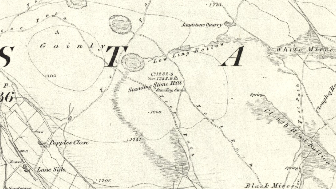
There are a couple of other possible standing stones on this section of moorland.  One in particular appears to have been taller in bygone times and is marked on the 1851 OS-map of the region about 100 yards southwest of the triangulation pillar (you’ll notice it on your right, off-path, as you’re walking towards the pillar—shown at the position on the map here, right).  Further west is the tall medieval Reaps Cross, where corpses were rested in their journey over the moors.

References:

  1. Bennett, Paul, The Old Stones of Elmet, Capall Bann: Milverton 2001.

© Paul Bennett, The Northern Antiquarian


Nanny’s Grave, Steeton, West Yorkshire

Tomb:  OS Grid Reference – SE 022 448

Archaeology & History

Until we’ve isolated this site, it’s difficult to suggest an age for it.  It’s an all-but forgotten grave of some sort, last mentioned by John Clough (1886) in his rare work on Steeton township.  Although the folklore indicates some medieval date here, the site may have been a prehistoric tomb, as it was located in the same valley a mile east of another little-known prehistoric burial at Crosshills.  Mr Clough wrote the following of the site:

“Until AD 1790 the road to Kildwick would be down Pot Lane and past ‘The Lion’.  Near a field, now called Nanny Grave Hill; there were four land ends; there are three lane ends yet; there was what i’s called Devil’s Lane, the lanes towards Eastburn and Steeton, and Wood Street… The junction of these four lane ends is the scene of one of Steeton’s tragedies.  At this place is buried a suicide called Nanny, with “a stake in her inside.”  Some people point out the mound under which she’s buried.  When the suicide took place isn’t known, but it would certainly not occur later than the 17th century.”

But there are no records telling of the said ‘nanny’ and her death, nor archaeological accounts of any excavations hereby.  The epithet nanny is sometimes used in northern counties to mean a witch, and although we have no remaining lore telling of such a character, the old name Devil’s Lane certainly infers some pre-christian or supernatural history hereby, common to many ancient burial mounds throughout Britain and across the world.  Also a burial at an old crossroads is another heathen indicator; and the legend of the body having “a stake in her inside” is highly suggestive of further archaic death rituals, fixing the spirit of the dead at the site to prevent transmigration of any form, effectively ending the lineage of shaman or other heathen priestess.  Any further information about this site would be most welcome.

References:

  1. Clough, John, History of Steeton, S. Billows: Keighley 1886.

© Paul Bennett, The Northern Antiquarian


Burhill Kiln Allotment (415), Appletreewick, North Yorkshire

Cup-and-Ring Stone:  OS Grid Reference – SE 07792 61829

Also Known as:

  1. Carving no.415 (Boughey & Vickerman)
Burhill’s cup-and-ring stone (image courtesy ‘QDanT’)

Getting Here

Probably the easiest way is to park up at Stump Cross Caverns on the B6265 road, then walk down the road for 200 yards till you reach the track on your left running over the fields in the direction towards Simon’s Seat.  Walk along the track past the Skyreholme Wall carving, where it starts going downhill and, 100 yards before you reach the fork in the tracks, look in the field on your left.  The other route is to go east through Appletreewick village up to and through Skyreholme as far as you can drive, where the dirt-track begins.  Keep going up till you hit the fork in the tracks.  Go left, then thru the first gate you come to and walk up into the second field up where the notable rock stands out.  If you can’t see it at first, look around!

Archaeology & History

Boughey & Vickerman’s plan of the carving

This carving was rediscovered by Stuart Feather (1964) in one of his ambles in the area — and he would have been pretty pleased when he found this one!  It is the most complex and ornate of all the prehistoric carvings in and around this large open field.  With at least nine cup-and-rings and more than fifty other cups etched onto its rounded upper surface, there are various other lines and grooves linking up some elements of this mythic design. The best ones are on the upright and sloping east-face of the rock, into the rising sun.  In animistic terms the rock is distinctly female in nature.

Illustrated in one of Stan Beckensall’s (1999) works, the rock art students Boughey & Vickerman (2003) also include it in their survey, but give an inaccurate grid reference for the site.  They nevertheless describe it as:

“Large upstanding rock with slightly domed top surface. Most of top surface decorated but weathering makes detail uncertain: over sixty cups, eight or more with rings, many grooves.”

Many other carvings can be found in the area.

References:

  1. Beckensall, Stan, British Prehistoric Rock Art, Tempus: Stroud 1999.
  2. Boughey, Keith & Vickerman, E.A., Prehistoric Rock Art of the West Riding, WYAS: Wakefield 2003.
  3. Feather, Stuart, “Appletreewick, W.R.” in ‘The Yorkshire Archaeological Register, 1963’, Yorkshire Archaeological Journal, 41 (part 162), 1964.
  4. Morris, Ronald W.B., “The Prehistoric Rock Art of Great Britain: A Survey of All Sites Bearing Motifs more Complex than Simple Cup-marks,” in Proceedings of the Prehistoric Society, volume 55, 1989.

Acknowledgements:  Huge thanks to the pseudonymous ‘QDanT‘ for use of the photo in this profile.  Cheers Danny!

© Paul Bennett, The Northern Antiquarian


Lowlands Well, Wycoller, Lancashire

Healing Well:  OS Grid Reference – SD 9317 3944

Archaeology & History

Lowlands Well

The huge stone trough at the side of the Wycoller Beck further down than the old bridge had a pipe leading to it from a spring on the other side of the beck.  Cookson & Hindle (1974) told that this was “the only source of drinking water” — which wasn’t quite true.  In the old photo shown here, the groove in the supporting vertical stone once held a lid over the top of the trough, “to prevent animals, dead leaves, etc, from fouling it.”  In addition to the old photo shown here, the well is also illustrated in Folley’s Romantic Wycoller (1949) with two young girls drinking the running water.

References:

  1. Bentley, John, Portrait of Wycoller, Nelson Local History Society 1975.
  2. Cookson, Stanley & Hindle, Herbert, Wycoller Country Park, H. Hindle: Colne 1974.
  3. Folley, E.W., Romantic Wycoller, Coulton & Co.: Nelson 1949.

© Paul Bennett, The Northern Antiquarian


Foulscales Stone, Newton, Lancashire

Carved Stone:  OS Grid Reference – SD 692 492

Also Known as:

  1. Bonstone
  2. Yolstone

Archaeology & History

An intriguing and little-known carved stone whose existence has been brought to our attention by historian and author John Dixon.  Its precise history and nature seems unknown; but aspects of the carving possess symbols that are found on early christian remains, as well as some cup-and-ring designs.  John wrote:

Artist’s impression
Foulscales Stone

“This enigmatic stone (27 inches height, 12 inches wide, 6 inch thickness), anciently known as the Yolstone and later as the Bonstone, once stood behind Foulscales Farm, near Gibbs.  For some reason the stone was removed from this site and taken into the cellars of Knowlmere Manor under the authority of the Peel Estate.

The stone displays possible early native chi-rho symbols that may have a 6/7th century provenance. The lettering ‘HT’ look to be of 16/17th century origin and may refer to the Towneley family who held lands in Bowland.”

Was it a boundary stone?  A gravestone?  Was it an early christian stone?  A Romano-British stone?  The carved circles with ‘crosses’ inside them are typical Romano-British period designs, covered extensively in the early works of J. Romilly Allen and found to be widespread across Britain.  Any further information on this stone would be greatly appreciated.

References:

  1. Dixon, John, Slaidburn and Newton, Bowland Forest, Aussteiger Publications: Clitheroe 2003.

© John Dixon & Paul Bennett, The Northern Antiquarian


Rudston Monolith, East Yorkshire

Standing Stone:  OS Grid Reference – TA 09803 67740

Getting Here

Rudston’s monolith (photo by ‘QDanT’)

To get to the monolith travel along the B1253 road to the west of Bridlington for about 5 miles or from York take the A166 in an easterly direction then onto the B1251 and at Fridaythorpe take the B1253 east again toward Bridlington. The huge stone cannot be missed from the road and from the surrounding area. It stands within the graveyard of All Saints’ church at the north-eastern side of Rudston village.

Archaeology & History

Located in the graveyard of All Saints’ church, this huge and mighty monolith or menhir stands at 25 foot 9 inches high (7.7 metres), and is the tallest prehistoric standing stone in Britain. It is estimated to weigh 40 tons, and it is thought to be the same in height below ground as what it is above the ground, though I don’t know whether anyone has ever checked that theory out. It probably dates from the Bronze-Age about 1,600 BC. Because of vandalism and erosion the top of the stone now has a lead cap, so it is said the stone could have originally been 28 feet high. So where has the top part gone to, I wonder. We are told that the stone was dragged, or rolled on logs, all the way from an outcrop at Cayton Bay some 10 miles as the crow flies to the north.

Royston’s 1873 drawing
Rudson Monolith (Louise Hutchinson 1988)

Rudston monolith stands at the end of at least one cursus monument on an old prehistoric alignment (see the Rudston B Cursus entry).  It would appear to have played an important ingredient in a huge ceremonial landscape on the Gypsey Race.  Also in the churchyard (north-east corner) there is a large slab-stone cist which was removed from a nearby round barrow and also a gritstone. At Breeze Farm about one mile to the south-west of the village is the site of a Roman villa.

Folklore

The folklore elements tell us that this is, in fact, a phallic stone and in pagan times some form of ritual was held around the monolith, but then the Christian church was built around it in the Dark Ages – it was a case of Christianity adopting the pagan religion and allowing the stone to stay where it was, but what else could they do because the stone was to big to move, so a lot of tolerance was in order here. The present church of All Saints’ dates from the Norman period. In any case the stone had stood here for a good 2,000 years or more before any church was established in the village. According to the legend, the devil hurled the huge stone at the first Christian church on the site, but as usual he just missed – doesn’t he always!

References:

  1. Bord, Janet & Colin, Ancient Mysteries of Britain, Diamond Books: London 1991.
  2. Anderton, Bill, Guide To Ancient Britain, Foulsham: London 1991.
  3. Darvill, Timothy, AA Glovebox Guide – Ancient Britain, AA Publishing Division: Basingstoke 1988.
  4. Royston, Peter, Rudston: A Sketch of its History and Antiquities, George Furby: Bridlington 1873.

© Ray Spencer, The Northern Antiquarian 2011


Two Lads, Withens Moor, West Yorkshire

Cairns: OS Grid Reference – SD 98394 22116

Getting Here

Best way here is, from Mytholmroyd go up the Cragg Vale road for a coupla miles, then turn right and heading down, then up, towards Withens Clough reservoir.  Once there, walk onto the moor to your left (south) until you’re on the ridge above you.  Keep walking until y’ see the rocky cairn-like creatures stood in isolation on a flat moorland plain.

Archaeology & History

Two Lads – on a dark, rainy, windy day

Truly weird spot this one, but I love it! Seemingly miles from anywhere, it’s one helluva walk to most folk, but utterly worthwhile when your arrive.   On a clear day you can see for miles and the landscape is adorable!  On a cloudy rainy day, the feel of the place changes if you take care to stay with the site, saturated, meditating (as no other people ever turn up when She’s like that – so you and the place get the best from each other!).

The site comprises of two boulders, each crowned with a cairn of stones.  The westernmost one of the two (SD 98392 22111) is intriguing as it has, carved upon the rock beneath the stone cairn on the northwestern edge of the stone, what looks like a singular cup-marking, plus a large water-worn bowl on its northern edge, and a very distinct deeply-cut cross-base, several inches deep, near the northeastern corner of the rock.  This cross-base seems slightly more rectangular in form than square; although the large covering of stones makes an accurate ascription difficult.  If this cross-base and cup-markings are authentic, we would have here a clear example of the christianization of a previously heathen site.

A cursory examination of the easternmost of the Two Lads (SD 98397 22117) doesn’t indicate any artificial workings on the rock surface.

Two Lads on 1853 OS-map

Although the two ‘cairns’ on top of these two rocks are not prehistoric in nature, about 20 yards behind the Two Lads (south) may once have been the severely denuded remains of a once large prehistoric cairn.  Although the position in the landscape is perfect for such a construction, this is somewhat tentative, it’s gotta be said!  Further examinations are obviously necessary here.

The studious A.H. Smith (1961-63) believes that a field-name record from 1624, describing some ‘Lad Stones’ in the parish of Heptonstall relates to this site.  We know with certainty however, that this site was first illustrated on Greenwood’s 1771 map of Yorkshire, then highlighted on more recent 19th century Ordnance Survey maps as ‘cairns.’

Folklore

Drawing of the Lads in 1877

The creation myth behind this place is that two lads were walking over the moor in midwinter and got caught in a blizzard. Losing all sense of visibility they tried to shelter from the wind and snow by hiding behind these rocks, but perished. Sometime later their bodies were found and the curious “cairn” of rocks were mounted onto the boulders to mark where they’d died.  This is a folktale we find at many other old stone remains on the hilltops of northern England and Scotland.

The Two Lads seems to be very close to a midwinter alignment (or izzit a lunar standstill line?), linking it with the huge Rudstoop Standing Stone and, eventually, Robin Hood’s Penny Stone on Midgley Moor – which might be the root of the folktale. (i.e. midwinter, snow, death)  Any archaeoastronomy buffs out there wanna check this one out?  Then we can confirm or dismiss it.

References:

  1. Anonymous, “The ‘Two Lads’, Withens Moor,” in Todmorden & Hebden Bridge Historical Almanack, T. Dawson: Todmorden 1877.
  2. Bennett, Paul, The Old Stones of Elmet, Capall Bann: Milverton 2001.
  3. Smith, A.H., The Place-Names of the West Riding of Yorkshire, Cambridge University Press 1961-63.

© Paul Bennett, The Northern Antiquarian 


Rocking Stone, Meltham Moor, West Yorkshire

Legendary Rock (destroyed):  OS Grid Reference – SE 0728 0944

Archaeology & History

The Rocking Stone in 1720

Here we have the case of yet another rocking stone destroyed by a bunch of morons in bygone days.  Although marked on the first Ordnance Survey of the region around 1850, the site had already been destroyed by then — but at least the surveyors had recorded its position in the landscape. And a dramatic and barren landscape it sat within!

It could be found high up in the middle of the moors above Brow Grains by the Wicken Stones, nearly 1400 feet above sea level, heading towards West Nab, and had lived here, safely, for untold thousands of years.  But then, on Whitsun Monday morning in either 1827 or 1828, there came, wrote Joseph Hughes (1866),

“some half-dozen masons (who) planned and executed the work of destruction for a frolic.  They first endeavoured to accomplish it by blasting it with gunpowder and, on the failure of this scheme, they fetched tools from Deer Hill, with which they drilled a hole and then wedged it, when the stone fell with a tremendous crash, hardly allowing the man on its summit who was drawing in the wedge to escape without injury.”

It’s a huge pity that the boulder didn’t crush him to death for his actions.  At least it would have taught the halfwits a lesson (forgive me if I sound a bit harsh – but I have an increasingly lower opinion of selfish humans the older I get).  Thankfully though, one hundred years before the stone was destroyed, Mr John Warburton of the Somerset Herald visited the region in 1720 and on one of the days here, took a long walk up to the Rocking Stone, from where we have this rare old drawing of the site.  As Mr Ahier (1942) told us,

“His sketch plainly shows one stone superimposed upon another, and it is conceivable that the uppermost stone could be rocked on the lower one.”

There was also another Rocking Stone in the locale, it too destroyed, this time “by a former gamekeeper” no less, using the time-honoured excuse:

“because persons going to see it crossed the moor, and, in doing so during the nesting season, were liable to tread on eggs or upon young birds.”

This excuse is an even poorer one these days (as any honest ranger will tell you – which includes me in my former capacity as an assistant moorland ranger), as walking the moors causes much less damage than the moorland “management” of draining the bogs, dyke cutting, grouse-shooting, bracken control, letting the Snoots drive their vehicles over the heathlands, upgrading modern footpaths, etc.  (God – I’m on a rant!)

References:

  1. Ahier, Philip, The Legends and Traditions of Huddersfield and District, Advertiser Press: Huddersfield 1942.
  2. Hughes, Joesph, The History of the Township of Meltham, John Russell Smith: London 1866.

© Paul Bennett, The Northern Antiquarian


Rocking Stone, Golcar, West Yorkshire

Legendary Rock (destroyed):  OS Grid Reference – SE 076 163

Also Known as:

  1. Holed Stone
  2. Holy Stone
  3. Whole Stone

Archaeology & History

Golcar rocking stone, 1799

Like many old rocking stones, this was destroyed due to quarrying operations many years ago and sadly, I believe, we have no illustrations of the place to show the site.  This legendary site—also known as the ‘Holed’ or ‘Holy Stone’—is preserved in the place-name of Rocking Stone Hill and, unlike many other alleged rocking stones, actually swayed to and fro if the old records are owt to go by.  Not far away (and also destroyed some 200 years back) were two stone circles which probably had some mythic relationship to this legendary rock.

The stone was first described by John Watson in his monumental History of Halifax (1775), where he told that is was,

“so situated as to be a boundary mark, dividing the two townships of Golcar and Slaightwait in the Parish of Huddersfield, adjoining to the Parish of Halifax on Wholestone Moor.  The stone as measured by the late Thomas Perceval, or Royton…is 10½ feet long, 9ft 4in or 5in broad, and 5ft 3in thick.  Its weight…is 18 tons, 190lbs.  It rests on so small a centre, that at one particular point, a man may cause it to rock; though some years ago it was damaged a little, in this respect, by some masons, who endeavoured, but in vain, to throw it off its centre, in order to discover the principle on which so large a weight was made to move.”

Mr John Crabtree (1836) included it in his survey, and it was illustrated on the very first Ordnance Survey map in the 1840s where it was described as ‘Supposed Druidical’.  But the old stone sadly didn’t last much longer.  Once the self-righteous Industrialists got here, round about the year 1886, the Rocking Stone was destroyed by quarrying operations.  All that remains of the place today is a small cluster of place-names..

Folklore

Thought by Watson (1775) and his contemporaries to have had druidic associations (without evidence), when Philip Ahier (1942) came exploring this area in 1936, he came upon “an old resident (who) informed me that he had sat upon the stone when a youth and had caused it to rock.”

References:

  1. Ahier, Philip, The Legends and Traditions of Huddersfield and District, Advertiser Press: Huddersfield 1942.
  2. Bennett, Paul, The Old Stones of Elmet, Capall Bann: Milverton 2001.
  3. Crabtree, John, Concise History of the Parish & Vicarage of Halifax, Hartley & Walker: Halifax 1836.
  4. Watson, John, The History and Antiquities of the Parish of Halifax, T. Lowndes: London 1775.

© Paul Bennett, The Northern Antiquarian 


Shorey Well, Burnley, Lancashire

Healing Well:  OS Grid Reference – SD 844 330

Also Known as:

  1. St. Audry’s Well
  2. Whitaker’s Well
  3. Whittaker’s Well

Archaeology & History

Shorey Well, Burnley (T.Ormerod, 1906)

Recently a good turn of fortune has brought about the discovery of a number of previously unpublished manuscripts detailing a number of prehistoric remains, holy wells and old stone crosses that existed in and around east Lancashire, Burnley, Cliviger and Todmorden.  Many of these papers are the all-but-lost writings of historian and antiquarian Clifford Byrne of Nelson.  Having never previously been published, I think his works deserve greater attention and so I’ll be slowly, gradually, sticking them on the internet and give them the wider audience they deserve.  Not all of his notions are necessarily accurate, but the extent of this mans local history knowledge on the sites he describes in his essays is considerable.  The following is his short essay—with minimal editing—on this all-but-forgotten site:

“Shorey Well, or rather its stone housing, was originally situated in the bank of the River Brun slightly upstream of the parish church at Burnley, at a spot now within the grounds of the Burnley Technical College.  From within the stone housing issued the spring proper, which then ran down the brookside into the river.

“From time immemorial until the late 19th century, Shorey Well supplied part of the town of Burnley with its drinking water, then the water was impounded into a pipe and the stone housing removed to a place of safety.  This housing was thought by our Victorian forebears to have sufficient merit to save it for posterity, and this act I feel implies more than a certain interest in the old stones which I suggest the movers of the Well probably did not themselves fully understand, and it is with this concept that I hope now to deal.

“The present location of the stones of Shorey Well is in the little triangle of greenery outside Prestige Ltd at Burnley.  This spot is bounded on Colne Road and Bank Parade.  Behind it squats the base of Burnley Market Cross and the remains of the stocks with — a little to one side — the shaft of the Godley Lane Cross standing out of a huge square pedestal.

“An old map in Burnley Library shows Shorey Well in situ with a well-defined row of stepping stones crossing the river directly in front.  This line of stones went to the site of a still existing property called Shorey Fold — a spot that was probably once called St. Audry’s Fold, as we shall see.

“Godly Lane Cross is an Anglo-Saxon monolith with a somewhat damaged head.  This damage was probably done around the time of the Reformation in the 16th century, when the anti-Catholic movement was at its height.  The name Godly implies a god-like, or god-inspired or religious tone to the area, and Godly Lane — now Ormerod Road — certainly lived up to its name for there stood the parish church, the Cross itself, the Market Cross, another cross dedicated to a priest in the 16th century and now standing in the rear of Townley Hall, “Foldy’s Cross”, with nearby Shorey Well.

“There is a strong possibility that the Godly Lane Cross — sometimes called the Paulinus Cross — was a preaching cross and that it also marked the way to Shorey Well which issued close by.

“No one to the knowledge of the writer has attempted to explain the name Shorey Well.  I therefore suggest that the Well was used for baptism and that it was dedicated to St. Audry.  The parish church was erected prior to the Reformation and thus certainly had its Holy Well close by, from which the priests obtained water for baptism and blessings, etc.  Because of its propitious nature and close proximity to the church, such a Well would almost certainly have been the Shorey Spring.

“A study of the name may be fruitful.  Holy wells are almost always dedicated to some christian saint.  However, many of them have undergone a slight change in name over the centuries, so that it is not always easy to recognise the dedication.  For instance, the Ransible Well near Colne was dedicated to Our Lady of Ransome, or the Virgin Mary; Stellern Well was dedicated to St. Helen; Maudlin Well near Lathom House was dedicated to St. Mary Magdalen; Pewter Well at Sabden  would be St. Peter’s Well; Mattus Well at Sawley Abbey is St. Matthew’s Well; whilst Cooks Well at Colne was surely dedicated to St. Luke the physician.  Thus Shorey Well in the same context is almost certainly dedicated to St. Audry, and this saint we find was one of the most revered saints in Anglo-Saxon times, from which date the Godly Lane Cross stems.

“The close proximity of church, well and cross surely imply that one showed the way to the other, and that all three were at one period of time one unit: the Cross being a preaching place prior to the Church, and the holy well being a place of baptism and healing.”

Mr Byrne’s etymological reasoning may or may not be right here (Mr Ekwall says nothing in his place-name survey and I’m unaware of local dialect analysis that may account for the word), but the description of this and numerous other lost and forgotten sites in his various papers is hugely worthwhile and is a source of considerable study for us over the coming months.

Ormerod (1906) described the site in his tome, but even in his day this once great well with its “abundance of sparkling water” was “disused and neglected.” (the image above is taken from his work) However, as if to dispel any notions of an earlier saintly dedication, we find that in Walter Bennett’s (1948) magnum opus, the site had a more prosaic title in bygone years:

“Whittaker’s Well, or Shorey Well as it was later known, was situated on the riverbank opposite Dawson Square, and was apparently the only public source of drinking water for the inhabitants of tge Top o’ th’ Town.”

References:

  1. Bennett, Walter, The History of Burnley – volume 3, Burnley Corporation 1948.
  2. Byrne, Clifford H., “A Short Study of Shorey Well, Burnley,” unpublished manuscript 1976.
  3. Ormerod, T., Calderdale, Lupton Bros: Burnley 1906.

© Paul Bennett, The Northern Antiquarian