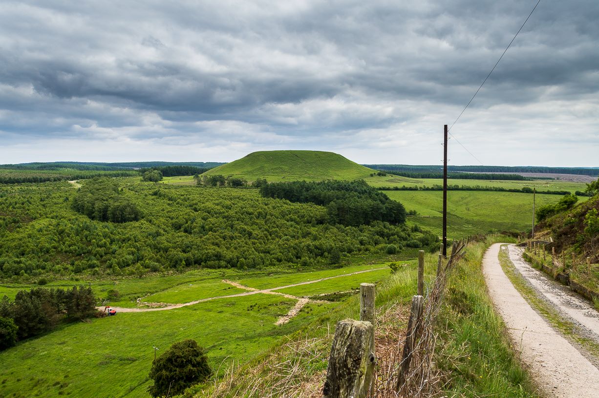
From Pickering, take the A169 towards Whitby. When you get to the Car Park at the ‘Hole-of-Horcum’ – (you can’t miss it), park the car and walk North along the side of the road towards Whitby. After 60 yds, take the track East. Follow this for approximately a mile until the track splits. Take the concrete track left towards the farmhouse of ‘Newgate Foot’. Go through the yard past the house on the right, and you will come to a stream and a gate and there, ahead of you, rises Blakey Topping…
Archaeology & History
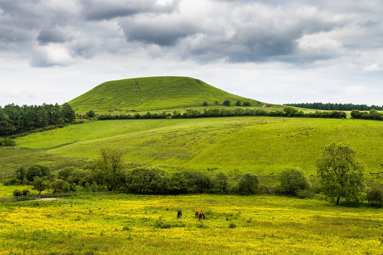
The giant hill of Blakey Topping was recorded as early as 1233 CE and in a simplistic style just means the ‘black mound’; but this derivation has additional ingredients, implying it as a ‘black meeting-place’ or moot. Black in the etymological sense also implies ‘shining’ and it may also relate to the northern airt of black (meaning death, darkness, north, etc), when you’re stood at the ruined stone circle 400 yards to the south. But I’m speculating here…
Several 19th century antiquarians suggested there may have once been a cairn on top of the hill, but others who’ve explored this idea seem to have put it to bed.
Folklore
This great hill is well recognised amongst local people and, to this day, its animistic creation myths and other folklore elements are still spoken. When the photographer James Elkington recently visited the nearby standing stones, he bumped into the old farmer who told him how his father had seen the faerie-folk on the hill many years back. And its modern reputation as a gorgeous site adds to such lore, which dates way back.
In Frank & Harriett Elgee’s (1933) archaeology work, they narrated the old creation myth that local people used to tell of this great hill,
“A witch story related by a native 25 years ago attempts to explain two conspicuous natural features two miles apart on Pickering Moor; Blakey Topping, an isolated hill, and the Hole of Horcum, a deep basin-shaped valley. The local witch had sold her soul to the devil on the usual terms, but when he claimed it, she refused to give it up, and flew over the moors, with the devil in hot pursuit. Overtake her he could not, so he grabbed up a handful of earth and flung it at her. he missed his aim and she escaped. The Hole of Horcum remains to prove where he tore up the earth and Blakey Topping where it fell to the ground.
“From our point of view the significance of this story lies in the fact that between the Hole and the Topping there is a Bronze Age settlement site at Blakey Farm, with its stone circle. The rough trackway leading from the Hole to the circle is known as the Old Wife’s Way, presumably also marking the witch’s flight. This, together with other Old Wife’s Ways, preserves as it were Bronze Age church tracks”.
Looking up from the SW (James Elkington)
A relative variation on this tells that the Hole of Horcum was made by the local giant, Wade. He was having a row with his wife, Bell, and got so angry that he scooped out a lump of earth and threw it at her. The huge geological feature known as the Hole of Horcum is the dip left where he scooped out the earth, and Blakey topping, the clod itself, resting in situ where it landed. A christian appropriation of the story replaces Wade and his wife with their ‘devil’: a puerile element unworthy of serious consideration.
In more recent times, the old geomancer Guy Ragland Phillips (1976; 1985) found that a number of alignments, or leys (known as a ‘node’), centred on Blakey Topping: twelve in all, reaching out and crossing numerous holy wells, prehistoric tumuli, standing stones, etc. The precision of the alignments is questionable, yet the matter of the hill being a centre-point, or omphalos, would seem moreso than not.
References:
Elgee, F. & H.W., The Archaeology of Yorkshire, Methuen: London 1933.
Phillips, Guy Ragland, Brigantia, RKP: London 1976.
Phillips, Guy Ragland, The Unpolluted God, Northern Lights: Pocklington 1987.
Smith, A.H., The Place-Names of the North Riding of Yorkshire, Cambridge University Press 1928.
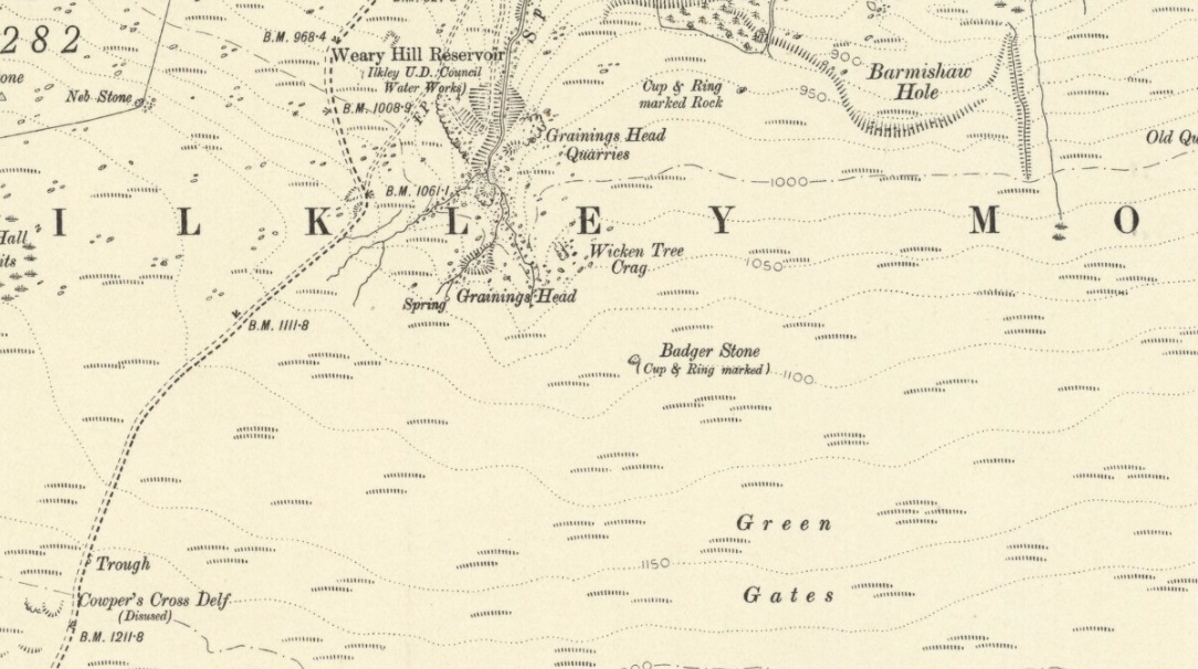
Although there are several routes to this site, for those who are not used to walking or find maps difficult to read [get a life!], it is best approached from the Ilkley side of the moor. Follow the old track that cuts the moor in half past the remains of Graining Head quarry where the moor begins to level out. Once here cut straight east until you find the footpath which, after a while, you will see leads to a wooden seat right in the middle of nowhere. Here is our Badger Stone.
Archaeology & History
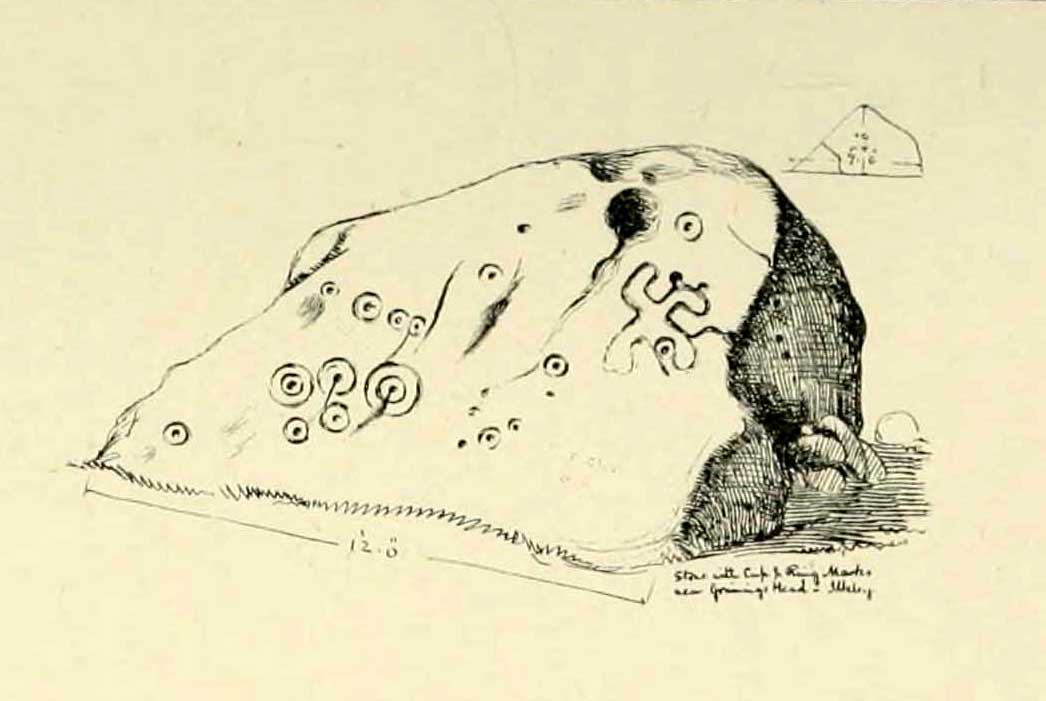
An eroded but quite excellent cup-and-ring stone — one of the very best on Ilkley Moor — comprising nearly a hundred cups, ten rings, what seems to be a half-swastika design, plus a variety of other odd motifs. It’s one of the best carvings on the entire moor and has been written about by many folk over the years. First described in an early essay on cup-and-ring stones by J. Romilly Allen (1879) — who must have visited it in poor light, as some elements of the carving weren’t noticed — he described it as a “sculptured stone near Grainings Head”, saying:
“This stone…is a block of gritstone 12ft long by 7ft 6in broad, by 4ft high. The largest face slopes at an angle of about 40° to the horizon, and on it are carved nearly fifty cups, sixteen of which are surrounded with single concentric rings. At the west end of the stone are a group, three cups with double rings and radial grooves. At the other end, near the top, is a curious pattern formed of double grooves, and somewhat resembling the “swastika” emblem… At the highest part of the stone is a rock basin 8in deep and 9in wide. On the vertical end of the stone are five cut cups, three of which have single rings. This is one of the few instances of cup and ring marks occurring on a vertical face of rock.”
Badger Stone on 1910 map
The title “badger” dates back to at least medieval times when, as the Yorkshire historian Arthur Raistrick (1962) explained, the word represented “a corn dealer, corn miller or miller’s man.” It is likely that this traditional title goes much further back, probably into prehistory, as grain was one of the earliest forms of trade. Very close to this sacred old stone are place-names verifying this, like Grainings Head and Green Gates. A little higher upon the moor is the twelfth century Cowper’s Cross (which used to have cup-markings etched upon it) where, tradition tells, a market was held that replaced an older one close by.
The Badger Stone carvingClose-up of cup-and-rings
Our Badger Stone rests beside the prehistoric track which Eric Cowling termed “Rombald’s Way” (after the legendary giant, Rombald, who lived with his old wife upon these hills): an important prehistoric route running across the mid-Pennines. This ancient route runs east-west, traditionally the time of year when agricultural needs are greatest at the equinoxes. This may have been the time when any ancient grain traders met here. (In modern times a number of archaeologists have emphasized such routes as “trade routes”: a notion that derives from the modern religion of Free Market Economics in tandem with the rise of Industrialism and social Darwinism, much more than the actuality of them as simple pathways or means of accessible movement).
There are accounts from other places in Yorkshire about these badger men. We find a number of other “badger” stones, gates, ways, stoops and crosses on our Yorkshire hills. One of them in North Yorkshire, wrote Raistrick (1962), “is an ancient trade way.” In Richmond, North Yorkshire, around the time of the autumn equinox, Badger men from across the Dales followed the old routes over the hills into town, held annual festivities and sold their grain. (see Smith 1989; Speight 1897) It is perhaps possible that our old Badger Stone would have been a site where some form of indigenous British Demeter was revered.
Sketch of Badger Stone carving
Some elements of the Badger Stone carving have what could be deemed as primitive human images (anthropomorphic) mainly on the northwestern side of the rock, emerging from the Earth Herself. And certainly amidst the same portion we have a very distinct ‘solar’ symbol, very much like the ones found at Newgrange and, for that matter, many other parts of the world.
Some New Age folk have given the fertility element to the Badger Stone a deeper status, using imagination as an aid to decode these old carvings. When feminist New-Age writer Monica Sjoo visited Badger Stone she described it as “erotic”, with the carvings giving her a distinct impression of “vulvas” and she also thought orgies of sorts had been enacted here. (Billingsley & Sjoo, 1993) The vulva imagery is a well-known idea to explain cup-and-rings and in some cases this will be valid; but when I passed an illustration of this rock-art to a number of people (all women), there was not a vulva to be mentioned — merely the OM symbol, sperm entering the egg, a snail, a bicycle, a willy, a paw-print, eyes, a face, a tadpole, cartoon breasts, the rear end of a dog, grapes, letters, numbers, ears and a snake! Awesome stuff! Take a look at the design yourself and see what you can see in it. Answers on a postcard please! (The dilemma of making specific interpretations of these carvings is that we tend to approach them with dominant ego perspectives, many of them reflecting little more than our own beliefs or search for identity, imposing unresolved journeys and conflicts on that which we encounter, as with the above case.)
As with prehistoric rock-art in general, they are a number of things: functional, ritual, history, spirit; different at each and every site. As if to exemplify this at Badger Stone, note how the detailed carvings have been executed mainly on the southern face of the stone. The northern face has little if anything to show on it. It would suggest therefore, that this stone had some mythic relationship with events during daylight hours. But we have to be careful here…
At sunrise on a good morning, we note how the eastern edges of this stone show up very clearly indeed. If Nature’s conditions are damp and wet (as they tend to be each morning on the hills), the visible outline of these cup-and-rings show up very clearly indeed. Oddly, as the sun then passes through the daytime sky each and every day on its cyclical movement, the petroglyphic content becomes a little less visible unless the stone is wet. Indeed at sun-high (midday period) the carving doesn’t show up as well as it did in the morning light. And we find the same characteristic as the sun goes to set in the west: where that part of the carved stone shows up very clearly again — much clearer than during full daytime hours. If rain has fallen, the glyphs stand out very clearly indeed.
As all cultures imbued the natural world with animistic, living qualities, it seems probable that these periods of the day (sunrise and sunset) were significant at this particular carving. It may be, very simply, that the Badger Stone “came to life” with the sunrise and its mythic nature was alive during this period; whereas with many other carvings (both on these moors and elsewhere in Britain) their strong mythic associations related to the northern Land of the Dead. But then, I could be talking bullshit!
The Badger Stone is also a strong contender for it being a painted stone. Many petroglyphs like this in other cultures were ceremonially coloured-in using lichens and other plants dyes at certain times of the day or year, relating specifically to important mythic relationships between the people and the spirit of the rock at such places. This probably occurred here.
References:
Allen, J. Romilly, “The Prehistoric Rock Sculptures of Ilkley,” in Journal of the British Archaeological Association, volume 35, 1879.
Bennett, Paul, The Old Stones of Elmet, Capall Bann: Milverton 2001.
Billingsley, John & Sjoo, Monica, “Monica Sjoo in West Yorkshire,” in Northern Earth Mysteries, no.53, 1993.
Boughey, Keith & Vickerman, E.A., Prehistoric Rock Art of the West Riding, WYAS: Leeds 2003.
Hedges, John, The Carved Rocks on Rombald’s Moor, WYMCC: Wakefield 1986.
Cowling, Eric T., Rombald’s Way, William Walker: Otley 1946.
Raistrick, Arthur, Green Tracks on the Pennines, Dalesman: Clapham 1962.
Smith, Julia, Fairs, Feasts and Frolics: Customs and Traditions in Yorkshire, Smith Settle: Otley 1989.
Speight, Harry, Romantic Richmondshire, Elliot Stock: London 1897.
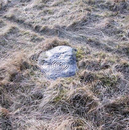
Best approached from the south, up Hardings Lane, then where its bends and the track of Parks Lane goes onto the moor, follow it. Onto the moor, keep on the track as it follows the walling until you reach the gate on your right. From here you’re close: head into the grasses and heather (left) not far off the western edge of the footpath at the eastern end of Dryas Dike. Look around!
Archaeology & History
This lovely looking carving “quite near to the footpath and enclosed fields above March Ghyll reservoir,” was first described by Stuart Feather. (1965) It can be found on a small flat stone and is easily obscured if the grasses are long – but it’s worth searching for. It’s an archetypal cup-and-ring stone, consisting of a cup-and-five rings, a cup-and-ring, and a cup-and-three rings — though they are rather faint and can be missed in bad light. As with other carvings, it’s best to splash water over it (as me & Richard did in the photo above) so you can see it a bit clearer. Feather (1965) told us:
“The symbols are very fine, consisting of three cup-and-rings. One of them, a quadruple, concentrically-circled cup with part of a fifth, unfinished ring. The cup is very shallow, 1 inch across, and the circles…½ inch wide and shallow, with an overall diameter of 8 inch for the four circles; 9 inch with the other unfinished section. The single cup-and-ring has a cup ¾-inch in diameter, ½-inch deep and a 4-inch diameter ring somewhat broader than the other rings on the rock and abutting on the north side against a slightly raised part of the rock surface.”
The triple-ringed cup is of similar dimensions to the larger example, with the cup being 1½ inch across and deep, with the circles being 7 to 7½-inch across.
About a half-mile northeast of here is the old Langbar Stone where I got the distinct impression that the same person was responsible for both of these carvings. God knows why!
References:
Boughey, Keith & Vickerman, E.A., Prehistoric Rock Art of the West Riding, WYAS 2003.
Feather, Stuart, ‘Mid-Wharfedale Cup-and-Ring Markings: No.32-3, Middleton Moor,’ in the Cartwright Hall Archaeology group Bulletin, February 1965.
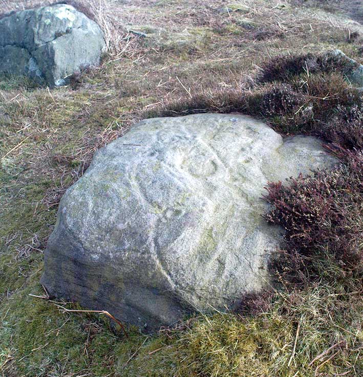
Best visited in winter and spring – thereafter the vegetation can hide it a little – but even then, it’s not too hard to find. Start from the Cow & Calf Hotel and walk across the road onto the moor, and head over as if you’re gonna walk above the Cow & Calf Rocks, onto the moorland proper. When you’ve gone a few hundred yards, walk up the slope (there are several footpaths – you can take your choice). Once on the ridge on top of the moor proper, you’ll see the Haystack Rock: it’s on the same ridge, right near where the moor drops down the slope about 250 yards west of here, just about next to the footpath that runs along the edge. Look around!
Archaeology & History
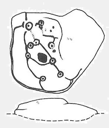
Unlike some folk who’ve seen this old stone, I find this carving superb. Its one of my favourites up here! Its alternative name – the Planet Stone – perhaps lends you to expect something more, but this is down to the astronomer who thought this was some type of heavenly image (which is most unlikely). I prefer to call it the ‘Map Stone’ because the correlates this carving has with indigenous aboriginal cup-and-rings is impressive and — to Aborigines anyway — would have all the hallmarks of a map. But not a ‘map’ in the traditional sense of modern humans. The incidence of cups and rings linked by curvaceous lines, typifies routes between water-holes or settlement spots made by ancestral beings — which is just what we find at this carving here. These ancestral beings need to be seen in a quite mythic sense: they may be creation deities (giants, gods, etc), animal spirits, the routes of shaman spirits, or other expressions of homo-religiosus.
Map Stone (note the carved line along the very edge of the rock)…and again from another angle
In the Map Stone here, we see that the very edge of the rock (fig.2 & 3) is ‘encircled’, perhaps (and I say perhaps) symbolic of the edge of the world. The lines and rings upon the top of the rock may symbolize journeys to and from important places. Another impression I get of this carving, with the “map” idea, is that the large pecked diamond-shaped ‘cup’ near the middle of the carving is a large body of water around which the archaic routeways passed. The next time anyone visits this stone, have a look at it with this idea in mind. Its simple, straightforward and makes sense (mind you – that doesn’t mean to say it’s right!).
The first account I’ve found of this comes from the pen of J. Romilly Allen (1882), where this stone “measuring 5ft 3in by 5ft, and 1ft 9in high” was described thus:
“On its upper surface, which is nearly horizontal, are carved thirteen cups, varying in diameter from 2 to 2½ in, eleven of which are surrounded by rings. There is also an elaborate arrangement of connecting grooves.”
Although we can only work our nine cup-and-rings here today, Mr Allen seemed suitably impressed with this old carving. Stan Beckensall (1999) seemed to have a good feel of this design too, describing it thus:
“Two thirds of the surface of this earthfast sandstone have been used in a design that partly encloses the marked part of the rock with long curvilinear grooves along its edge, and the inner grooves link single rings around cups. The effect is one of inter-connection and fluidity.”
Hedges 1986 sketch
The Map Stone was also looked at to examine the potential for Alexander Thom’s proposal of a megalithic inch: a unit of measure speculated to have been used in neolithic and Bronze Age times for the carving of cup-and-ring stones. Using nine other carvings on these moor as samples, Alan Davies (1983, 1988) explored this hypothesis and gave the idea his approval. However the selectivity of his data, not only in the carvings chosen, throws considerable doubt on the idea. Unfortunately the idea doesn’t hold water. The ‘geometry’ in the size of cup-and-rings relates more to the biometrics of the human hand and not early scientific geometry, sadly….
References:
Allen, J.R., ‘Prehistoric Rock Sculptures of Ilkley,’ in Journal British Arch. Assoc., 35, 1879.
Allen, J.R., ‘Notice of Sculptured Rocks near Ilkley, with some Remarks on Rocking Stones,’ in Journal British Arch. Assoc., 38, 1882.
Allen, J.R., ‘Cup and Ring Sculptures on Ilkley Moor,’ in Reliquary Illus. Archaeology, 2, 1896.
Beckensall, Stan, British Prehistoric Rock Art, Tempus: Stroud 1999.
Boughey, K.J.S. & Vickerman, E.A., Prehistoric Rock Art of the West Riding, WYAS: Exeter 2003.
Collyer, Robert & Turner, J.H., Ilkley: Ancient and Modern, William Walker: Otley 1885.
Cowling, E.T., Rombald’s Way, William Walker: Otley 1946.
Davis, Alan, ‘The Metrology of Cup & Ring Carvings near Ilkley in Yorkshire,’ Science Journal 25, 1983.
Davies, Alan, ‘The Metrology of Cup and Ring Carvings,’ in Ruggles, C., Records in Stone, Cambridge 1988.
Hedges, John, The Carved Rocks on Rombald’s Moor, WYMCC: Wakefield 1986.
Alan Davies’ image of the carving – with carved ‘lake’ near centre