River Avon Stone, Bulford, Wiltshire

Standing Stone (lost):  OS Grid Reference – SU 161 432

Archaeology & History

In William Stukeley’s Stonehenge, he described a number of monoliths outlying Salisbury Plain that also possessed a prehistoric pedigree.  Most of them have been recorded, but this one seems to have been forgotten about — perhaps by virtue of it having fallen into the River Avon!  Edgar Barclay (1895) described it in his fine survey, saying:

“In the bend of the river below the village, is a large submerged stone; only during drought is any portion of it visible above water; it can, however, in ordinary times, be dimly seen from the bank, which is of chalk, here very steep and overgrown.  The country people assert that a metal ring, “turning always,” is let into its upper end.  Legend relates that when the Devil brought the rocks of Stonehenge from Ireland, tied together with withes, this stone escaped from the bundle and fell into the river.  Its position forbids the belief that it got fixed in the bed of the stream when its passage to Stonehenge was being attempted, for it lies immediately beneath the crest of a very steep bank, and at its most inaccessible point; as the stream sweeps against this, the water must always have been deep at this spot, the open valley would everywhere offer more favourable points for such an operation, especially would this be the case before the Avon was dyked.  A boundary stone would have been placed on the brow of the hill; if the stone be a grey-wether, as report says, and as is probable, it may originally have stood on the bank, and “once upon a time”, a ring having been fixed in it, it may have been dragged into the stream to moor a ferry-boat.  It lies closely midway between the stone on Bulford Down and that in Durrington fields.”

One wonders if any local people might know more about this…

References:

  1. Barclay, Edgar, Stonehenge and its Earth-works, D. Nutt: London 1895.

© Paul BennettThe Northern Antiquarian

Woodhenge Circle (4), Durrington, Wiltshire

Round Barrow (destroyed):  OS Grid Reference — SU 1510 4330

Also Known as:

  1. Durrington 70

Archaeology & History

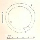
Cunnington’s sketch of the barrow remains

This was one of four ploughed-out round barrows (or ‘ring ditches’ in modern archaeo-jargon) that once existed immediately southeast of the well-known Woodhenge and was the closest of the four to the monument, being just 60 yards away. It was first noticed as a faint crop mark in an aerial survey photograph taken in 1926 of the fields hereby.  When it was investigated at ground level by Mr & Mrs Cunnington in August 1928, “no trace could be detected on the surface” of any extant monument—which they described as ‘Circle  IV’ in their superb survey.

The Cunnington’s (1929) account of the excavation they did here was pretty brief, telling:

“The soil was removed and the chalk brushed over that part of the area enclosed within firm lines.  Beyond a few shards of pottery in the soil, nothing whatever was found.  As the ditch was comparatively shallow and the filling-in was in patches dark in colour, with much ash and some burnt flints in it, a considerable length was dug out, as shown (in the sketch, above).  A few fragments of pottery similar to some of that from Woodhenge were found in and below the old turf line.

“The only find of interest was that of a piece of glass slag on the actual bottom of the ditch.  It is true it was at the shallowest point, but there was no evidence of disturbance.

“Conclusion — Like those of the other rings (Woodhenge Circles 1, and 3, PB) this ditch may have originally surrounded a Bronze Age burial, placed on the surface and covered with a mound, both of which were destroyed when the ground was levelled.”

References:

  1. Cunnington, M.E., Woodhenge, George Simpson: Devizes 1929.
  2. Royal Commission Historical Monuments, England, Stonehenge and its Environs, Edinburgh University Press 1979.
  3. Wainwright, G.J. & Longworth, Ian, Durrington Walls: Excavations 1966-1968, Society of Antiquaries: London 1971.

© Paul Bennett, The Northern Antiquarian

Woodhenge Circle (3), Durrington, Wiltshire

Round Barrow (destroyed):  OS Grid Reference — SU 1511 4327

Also Known as:

  1. Durrington 69

Archaeology & History

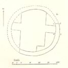
Cunningham’s sketch of Woodhenge-3 barrow

This was one of four ploughed-out round barrows (or ‘ring ditches’ in modern archaeo-jargon) that once existed immediately southeast of the well-known Woodhenge complex, constructed approximately 95 yards away.  As with others in this field, the site was first noticed as a faint crop mark in an aerial survey photograph taken in 1926.  When it was subsequently investigated at ground-level by Mr & Mrs Cunnington in August 1928, “no trace could be detected on the surface” of the monument in question—which they described as ‘Circle  III’ in their superb survey.

Very little was found in the Cunnington’s (1929) excavation, as their following brief account indicates:

“The soil was removed and the surface of the chalk brushed, over the whole of the area enclosed within this ditch.

“Only one small oval-shaped hole was found, near the edge of the ditch at “a” (above), 33in x 22in, and only 5in deep in the chalk; in it were a number of fragments of bones of a small ox and pig, a piece of burnt clay and a flint scraper weathered white.

“As there was nothing dateable in the circle it was not thought worth while to excavate more than a short section of the ditch.  Pottery comparable with that found at Woodhenge came from the old turf line and from the bottom of the ditch.

“Conclusion — Like those of the other circles (Woodhenge circles 1, 2 and 4, PB) it is probable that this ditch was originally made round a Bronze Age burial that had been placed on the surface, and that it was destroyed together with the covering mound when the ground was levelled.”

References:

  1. Cunnington, M.E., Woodhenge, George Simpson: Devizes 1929.
  2. Royal Commission Historical Monuments, England, Stonehenge and its Environs, Edinburgh University Press 1979.
  3. Wainwright, G.J. & Longworth, Ian, Durrington Walls: Excavations 1966-1968, Society of Antiquaries: London 1971.

© Paul Bennett, The Northern Antiquarian