Barley Cross, Richmond, North Yorkshire

Cross (destroyed):  OS Grid Reference – NZ 1709 0085

Archaeology & History

This was one of at least four old stone crosses that used to exist in Richmond.  It was accompanied by other functional edifices nearby known as the Oat Cross and Wheat Cross.  Like its companions, the Barley Cross is thought to have been the site where this grain was traded.  An early reference to it is Chris Clarkson’s (1814) survey, where he told us that not far from the old Market Cross,

“was formerly another, which went by the name of Barley Cross, perhaps so named from that sort of corn being sold there: it was a lofty Pillar of one large stone upon a small flight of steps with a cross at the top: rings were fastened to it, where criminals were punished by whipping: it is not long since it was taken down.”

Barley Cross (centre left) on 1724 town plan

Similar punishments were also administered to people at the original old Market Cross.  The grand masters of of Yorkshire history, Edmund Bogg (1908) and Harry Speight (1897) also mentioned this antiquity, but added nothing more.

The cross was highlighted on a 1724 plan of Richmond, just below the larger Market Cross.  In 1780 the local council ordered it to be demolished and, at a later date, large weighing scales were erected on the spot next to where it had stood, on the south-west side of the Trinity Church in the market square.

References:

  1. Bogg, Edmund, Richmondshire, James Miles: Leeds 1908.
  2. Clarkson, Christopher, The History of Richmond, T. Bowman: Richmond 1814.
  3. Home, Gordon, Yorkshire Dales and Fells, A. & C. Black: London 1906.
  4. Speight, Harry, Romantic Richmondshire, Elliot Stock: London 1897.

© Paul BennettThe Northern Antiquarian

Devil’s Stone, Addlebrough, Bainbridge, North Yorkshire

Legendary Rock:  OS Grid Reference – SD 943 880

Getting Here

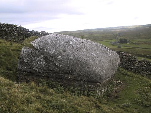
From the small town of Bainbridge, head south down the Carpley Green Road. Less than a mile before the end, look to the west-facing slope of Addlebrough Hill and this huge Devil’s Stone can be seen resting halfway up the slope.

Archaeology & History

Devil's Stone, Addlebrough
Devil’s Stone, Addlebrough

One of the legends of this place suggested there might be cup-and-ring markings on the stone, but the curious markings on top of the rock seem to be natural.  It’s a superb stone though, dropped here no doubt by some great glacier as it retreated north, in ages truly olde…

There’s a lot of archaeology round here that aint in the books.  We’ve come across some intriguing stuff of late, which you’ll read about soon enough.

Folklore

One legend tells that long ago Addlebrough was the home of a great unnamed giant — but a friendly giant by all acounts.  However, one day the devil turned up and wanted possession of the giant’s hill and so a fierce row broke out between them.  Perched on the top of the crag — which is the rough ridge to the west of here — the giant who lived here hurled huge boulders down at the devil, but they fell short and landed at the side of Lake Semerwater (itself an important spot in local prehistory).  In return, Old Nick himself began throwing boulders back — and one of those which the devil threw landed here, halfway up the western flank of Addlebrough Hill (a couple of the large granite boulders which the giant threw can be seen on the edge of Semerwater and are known as the Carlow and Mermaid stones).  Hence it’s name of the Devil’s Stone!

In Edmund Bogg’s Richmondshire (1908), he told how, “the curious markings on (the Devil’s Stone) are accounted due to the pressure of the devil’s fingers” which were caused when he threw this giant stone from somewhere to here.

This is a theme we find at countless other stone sites, i.e. the Devil burning holes into rock — and in some cases these devil’s “fingerprints” have turned out to be prehistoric cup-markings.  Such tales relate to the pre-christian Creation Myth of a place and would, before the “devil” was supplanted onto a site, have had wider significance in the landscape as a whole, in a manner known to the local people.  Devils usually replaced legendary giants, or hero-figures, who created the land in primordial times according to the myths of our ancient ancestors.  A greater examination of the nearby sites in association with the folklore of the region would no doubt be quite profitable…

References:

  1. Bogg, Edmund, Richmondshire, James Miles: Leeds 1908.

© Paul Bennett, The Northern Antiquarian

Hood Hill Stone, Kilburn, North Yorkshire

Legendary Rock:  OS Grid Reference – SE 503 812

Getting Here

From Kilburn village, take the north road up past the church for about 300 yards, bearing up the track on your left and walk up into the wooded hill a mile ahead of you.  It’s in there!

Folklore

In this region there’s a teeming cluster of druid, fairy, devil and spook-lore, along with numerous prehistoric remains. Not sure this site has such an archaic pedigree, though the creation myth told of this rock (marked on the 1st edition OS-map as an antiquity) seems to imply as such. Our old devil disguised himself as a druid many moons ago in an attempt to gain favour with the old priests, but was discovered in his plans and so, in anger, flew out across the hills carrying a great stone with him which he dropped from the skies and it landed where the Hood Hill Stone still remains. Also in anger he jumped down and stood on the great rock, and in doing so left his footprint impressed upon the stone. (There’s the possibility this is an unrecognised cup-marking – having not been here I can’t say misself).  Edmund Bogg (1906) also tells us that,

“The monk’s hood-like configuration of the crest is said to have originated its name. The busy tongue of tradition, however, says that the name commemorated Robin Hood who, with his merry men, affected the hill-fastnesses hereabouts; but the hill was named ‘Hode’ long, long before the famous Robin came this way at all.”

The same writer also told how,

“legend, too, has it that the happy valley just north of Hood Hill…was a secluded and sacred retreat of the druids, and at the introduction of christianity into these parts, a great assembly gathered to consider which of the two religions should in future be adopted.”

Yet another legend – and an old one, says Bogg – is “that when the dinner-bell rang at Osgodby Hall the stone rolled down for its repast, and regularly returned to the crest after the meal.”

It’s blatantly obvious that something of antiquity this way hides.  The “enclosure” shown on the modern OS-maps here could do with being looked at little closer.

References:

  1. Bogg, Edmund, Richmondshire and the Vale of Mowbray (volume 1), James Miles: Leeds 1906.

© Paul Bennett, The Northern Antiquarian