Standing Stone (lost): OS Grid Reference – SU 161 432
Archaeology & History
In William Stukeley’s Stonehenge, he described a number of monoliths outlying Salisbury Plain that also possessed a prehistoric pedigree. Most of them have been recorded, but this one seems to have been forgotten about — perhaps by virtue of it having fallen into the River Avon! Edgar Barclay (1895) described it in his fine survey, saying:
“In the bend of the river below the village, is a large submerged stone; only during drought is any portion of it visible above water; it can, however, in ordinary times, be dimly seen from the bank, which is of chalk, here very steep and overgrown. The country people assert that a metal ring, “turning always,” is let into its upper end. Legend relates that when the Devil brought the rocks of Stonehenge from Ireland, tied together with withes, this stone escaped from the bundle and fell into the river. Its position forbids the belief that it got fixed in the bed of the stream when its passage to Stonehenge was being attempted, for it lies immediately beneath the crest of a very steep bank, and at its most inaccessible point; as the stream sweeps against this, the water must always have been deep at this spot, the open valley would everywhere offer more favourable points for such an operation, especially would this be the case before the Avon was dyked. A boundary stone would have been placed on the brow of the hill; if the stone be a grey-wether, as report says, and as is probable, it may originally have stood on the bank, and “once upon a time”, a ring having been fixed in it, it may have been dragged into the stream to moor a ferry-boat. It lies closely midway between the stone on Bulford Down and that in Durrington fields.”
One wonders if any local people might know more about this…
References:
Barclay, Edgar, Stonehenge and its Earth-works, D. Nutt: London 1895.
Round Barrow (destroyed): OS Grid Reference — SU 1510 4330
Also Known as:
Durrington 70
Archaeology & History
Cunnington’s sketch of the barrow remains
This was one of four ploughed-out round barrows (or ‘ring ditches’ in modern archaeo-jargon) that once existed immediately southeast of the well-known Woodhenge and was the closest of the four to the monument, being just 60 yards away. It was first noticed as a faint crop mark in an aerial survey photograph taken in 1926 of the fields hereby. When it was investigated at ground level by Mr & Mrs Cunnington in August 1928, “no trace could be detected on the surface” of any extant monument—which they described as ‘Circle IV’ in their superb survey.
The Cunnington’s (1929) account of the excavation they did here was pretty brief, telling:
“The soil was removed and the chalk brushed over that part of the area enclosed within firm lines. Beyond a few shards of pottery in the soil, nothing whatever was found. As the ditch was comparatively shallow and the filling-in was in patches dark in colour, with much ash and some burnt flints in it, a considerable length was dug out, as shown (in the sketch, above). A few fragments of pottery similar to some of that from Woodhenge were found in and below the old turf line.
“The only find of interest was that of a piece of glass slag on the actual bottom of the ditch. It is true it was at the shallowest point, but there was no evidence of disturbance.
“Conclusion — Like those of the other rings (Woodhenge Circles 1, and 3, PB) this ditch may have originally surrounded a Bronze Age burial, placed on the surface and covered with a mound, both of which were destroyed when the ground was levelled.”
References:
Cunnington, M.E., Woodhenge, George Simpson: Devizes 1929.
Royal Commission Historical Monuments, England, Stonehenge and its Environs, Edinburgh University Press 1979.
Wainwright, G.J. & Longworth, Ian, Durrington Walls: Excavations 1966-1968, Society of Antiquaries: London 1971.
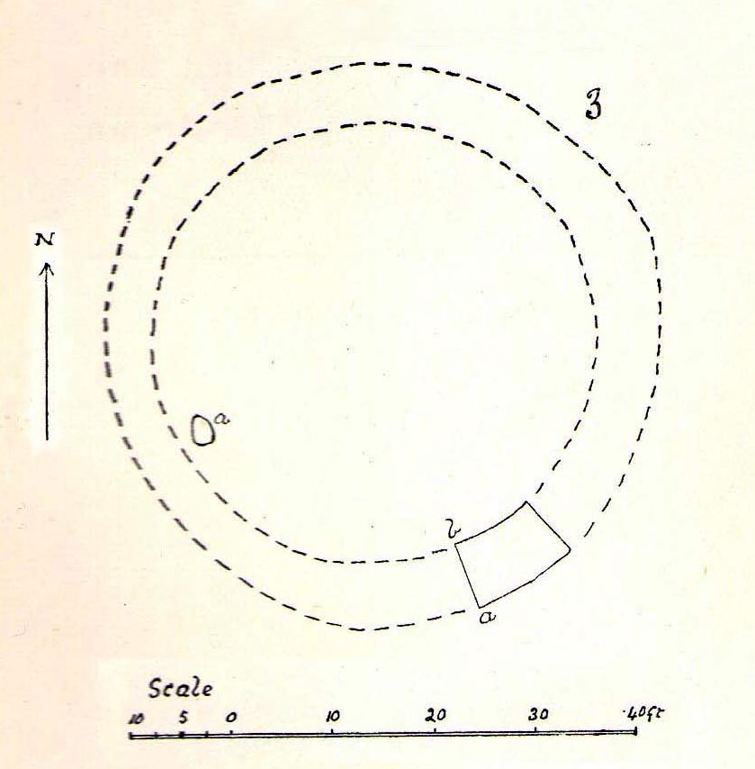
Round Barrow (destroyed): OS Grid Reference — SU 1511 4327
Also Known as:
Durrington 69
Archaeology & History
Cunningham’s sketch of Woodhenge-3 barrow
This was one of four ploughed-out round barrows (or ‘ring ditches’ in modern archaeo-jargon) that once existed immediately southeast of the well-known Woodhenge complex, constructed approximately 95 yards away. As with others in this field, the site was first noticed as a faint crop mark in an aerial survey photograph taken in 1926. When it was subsequently investigated at ground-level by Mr & Mrs Cunnington in August 1928, “no trace could be detected on the surface” of the monument in question—which they described as ‘Circle III’ in their superb survey.
Very little was found in the Cunnington’s (1929) excavation, as their following brief account indicates:
“The soil was removed and the surface of the chalk brushed, over the whole of the area enclosed within this ditch.
“Only one small oval-shaped hole was found, near the edge of the ditch at “a” (above), 33in x 22in, and only 5in deep in the chalk; in it were a number of fragments of bones of a small ox and pig, a piece of burnt clay and a flint scraper weathered white.
“As there was nothing dateable in the circle it was not thought worth while to excavate more than a short section of the ditch. Pottery comparable with that found at Woodhenge came from the old turf line and from the bottom of the ditch.
“Conclusion — Like those of the other circles (Woodhenge circles 1, 2 and 4, PB) it is probable that this ditch was originally made round a Bronze Age burial that had been placed on the surface, and that it was destroyed together with the covering mound when the ground was levelled.”
References:
Cunnington, M.E., Woodhenge, George Simpson: Devizes 1929.
Royal Commission Historical Monuments, England, Stonehenge and its Environs, Edinburgh University Press 1979.
Wainwright, G.J. & Longworth, Ian, Durrington Walls: Excavations 1966-1968, Society of Antiquaries: London 1971.
James Fergusson’s drawing of both cursus monuments
Just like its much larger companion, the Stonehenge Cursus earthwork a short distance to the south, this Lesser or Small Cursus is generally deemed by archaeologists to “speak of a clear religious or ritual aspect to this patch of downland that…reaches back generations before the first Stonehenge was built.” (Pitts 2001) The monument was aligned roughly east-west, showing possible relationships with the rising and setting of both sun and moon. (though I wouldn’t get too carried away with that misself…)
When Fergusson (1872) described this and its larger cursus companion a few hundred yards away, he thought they may have been dug to mark out lines of battle in prehistoric times, denouncing the horse-racing course hypothesis that was still in vogue at the time. His theory drew evidence from the numerous prehistoric tombs scattering this area of Salisbury Plain, but seemed more influenced by notions of prehistoric barbarism and warfare than ideas relating to a cult of the dead — which was yet to reach it heights in the archaeological minds of Victorian England. But, like other cursus monuments all over the British Isles, this one also seemed to have a distinct relationship with monuments of the dead: for at its western extremity (until being ploughed out of existence) was a large round barrow, catalogued as the “Winterbourne 35” tomb. Tim Darvill (2006) tells its wider tale:
“Levelled by ploughing between 1934 and 1954, the Lesser Cursus was investigated in 1983 as part of the Stonehenge Environs Project… Three trenches were cut into different parts of this large monument, showing that there were at least two main phases to its construction. Phase 1 comprised a slightly trapezoidal enclosure 200m by 60m, whose ditch may have been recut more than once and in part at least deliberately back-filled. In Phase 2 this early enclosure was remodelled by elongating the whole structure eastwards by another 200m. This extension comprised only two parallel side ditches, making the whole thing about 400m long with a rectilinear enclosure at the west end with entrances in its northeast and southeast corners giving access into a second rectilinear space, in this case open to the east.”
Lesser Cursus aerial viewGround-plan of the Lesser Cursus (after Richards 1990)
The entire structure had finds dating from the periods between 3650-2900 BC; and the aerial imagery showing an oval-shaped structure near the eastern end was confirmed by geophysical surveys — though precisely what this is has yet to be ascertained.
It seems likely that this and other cursus monuments were, to a very great degree, not only related to mortuary practices but — as their development occurred at the same time as the destruction of Britain’s great forests began — to be monuments to the gods themselves. This seems very evident at a couple of cursus monuments where animal deposits were made in some of the great mounds at their terminii, where archaeologists had previously assumed— incorrectly — the mounds to have been human burial mounds. More about this in due course…
References:
Darvill, Tim, Stonehenge: The Biography of a Landscape, Tempus: Stroud 2006.
Devereux, Paul, The Haunted Land, Piatkus: London 2001.
Fergusson, James, Rude Stone Monuments in all Countries, John Murray: London 1872.
Loveday, Roy, Inscribed Across the Landscape, Tempus: Stroud 2006.
North, John, Stonehenge, Harper-Collins: London 1997.
Pitts, Mike, Hengeworld, Arrow: London 2001.
Richards, Julian, The Stonehenge Environs Project, English Heritage: London 1990.
Not far south of the smaller Lesser Cursus monument, this huge linear earthwork was the very first cursus to be described, by William Stukeley no less, who thought it to be an old race-course for charioteers and the like! He stumbled upon this: a curious gigantic linear earthwork feature, stretching for nearly two miles roughly east-west and as wide a football field, cut into the Wiltshire Earth, betraying all notions of ‘primitive’ histories as proclaimed by the ‘intellectuals’ of his day. They were clearly wrong! This immense enigmatic structure, still baffles the same creed of intellectuals to this day — but at least our old ancestors have been granted greater abilities than previously believed. In his book on Stonehenge in 1740, Mr Stukeley described this,
“most noble work, contriv’ed to reach from the highest ground of two hills, extended the intermediate distance over a gentle valley; so that the whole cursus lies conveniently under the eye of the most numerous quantity of spectators. To render this more convenient for site, it is projected on the side of more rising ground, chiefly looking towards Stonehenge. A delightful prospect from the temple, when this vast plain was crowded with chariots, horsemen and foot, attending these solemnities with innumerable multitudes.”
Sir Norman Lockyer propounded its function as astronomical, aligning with the Pleiades around 2000 BC — a date we now know to be inconsistent with its construction, although as John North said in his Stonehenge (1997):
“Lockyer’s chronology was certainly better than the general archaeological consensus at the time.”
But further archaeological alignments and leys have been suggested running eastwards from here. And as Paul Devereux pointed out, “In the case of this cursus, archaeology got there first.” J.F.S. Stone, who carried out some excavations at the cursus in 1947, noted that
“its axis, if projected 1500 yards east, strikes Woodhenge and passes the Cuckoo or Cuckold Stone by the way.”
This was endorsed in 1981 by archaeologists John Hedges and David Buckley:
“In addition to aligning upon Woodhenge, the Greater Stonehenge cursus also sights upon the Cuckoo or Cuckold Stone.”
Alignment to Beacon Hill
In Roy Loveday’s (2006) survey of cursus monuments he told how this alignment goes much further, telling how it aligns “on the lower, northernmost prominence of Beacon Hill 8km away”, crossing Woodhenge on its way. Such suggestions used to bring outcries of derision from the archaeological fraternity, but it seems archaeologists themselves are making such claims more and more these days. At the forefront of modern alignment research in previous decades was Paul Devereux — and it was he who first noted the line-up with the distant Beacon Hill from the Great Cursus, telling:
“The course of the alignment can be extended eastwards a few miles beyond Woodhenge to cross the barrow-dotted ridge of Beacon Hill — a perfect example of a Wakins-style ‘initial point.’ The ridge is highly visible from Woodhenge. It disappears from view as one walks westwards down the cursus, but reappears clearly as the west end is approached. Indeed, the west end is so placed that it is at about the furthest point from which the Beacon Hill ridge , and the intermediate on which the eastern end of the cursus fall, can be seen together.”
…to be continued…
References:
Burl, Aubrey, A Brief History of Stonehenge, Robinson: London 2007.
Hedges, John & Buckley, David G., The Springfield Cursus and the Cursus Problem, Essex County Council 1981.
Loveday, Roy, Inscribed Across the Landscape, Tempus: Stroud 2006.
North, John, Stonehenge, Harper-Collins: London 1997.
Pennick, N. & Devereux, P., Lines on the Landscape: Leys and other Linear Enigmas, Hale: London 1989.
Stone, J.F.S., ‘The Stonehenge Cursus and its Affinities,’ in Archaeological Journal, 104, 1947.

")

")
")
")