Churn Milk Joan, Midgley Moor, West Yorkshire

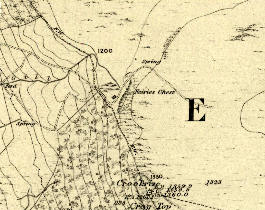
Standing Stone:  OS Grid Reference – SE 01974 27684

Also Known as:

  1. Saville’s Low

Getting Here

Churn Milk Joan, Midgley

From the village of Midgley, high above the A646 Halifax-to-Todmorden road, travel west along the moorland road until you reach the sharp-ish bend in the road, with steep wooded waterfall to your left and the track up to the disused quarry of Foster Clough.  Go up the Foster Clough track for 100 yards and, when you reach the gate in front of you, go over it but follow the line of the straight walling uphill by the stream-side (instead of following the path up the quarries) all the way to the top. Here you’ll see the boundary stone of  Churn Milk Joan.

Archaeology & History

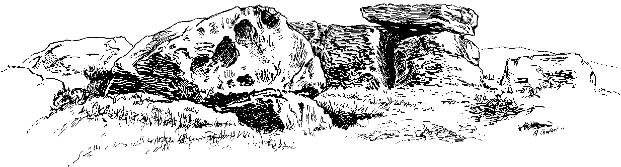
The present large standing stone you see before you isn’t prehistoric.  However, the small broken piece on the ground by its side may have been its prehistoric predecessor; and there is certainly something of an archaic nature here — albeit a contentious one — as we find old cup-markings cut into its eastern face.

Two ‘cup-marks’ on eastern face

The upright is roughly squared and faces the cardinal points.  It was described in Mr Heginbottom’s  (1977) unpublished survey on Calderdale rock art, where he described there being a few cup-markings inscribed on its east- and south-facing edges, some of which may be prehistoric — though they would obviously have had to have been carved upon the upright stone when it still lay earth-fast.  However, we must posit the the notion (unless some of you have better ideas) that the tradition of etching cup-marks onto rocks was still occurring in this part of Yorkshire until the late Middle Ages, as this stone was, as we know from boundary records, only placed upright to mark the meeting of the three boundaries of Wadsworth, Hebden Royd and Sowerby.

Churn Milk Joan’s other name, Saville’s Low, originates from the great Saville family who owned great tracts of land across the region in the fourteenth century, possibly when the Churn Milk Joan we see today was created.  The word “lowe” may derive from the old word meaning, “moot or gathering place,” which this great stone probably served as due to its siting at the junction of the three townships.*

Folklore

In modern times the stone has become a focus for a number of local pagans and New Agers who visit and ‘use’ the site in their respective ways at certain times of the day, albeit estranged (ego-bound) from the original mythic nature of the site.

The name of the stone comes from an old legend about a milk-maid named Joan who, whilst carrying milk across the moors between Luddenden and Pecket Well, got caught in a blizzard and froze to death.  When her body was found many days later, the stone we see here today was erected to commemorate the spot where she died.  Although such a scenario is quite likely on these hills, as Andy Roberts (1992) said,

“Considering the sheer amount of sites with similar legends this explanation is unlikely to be true and we should looker deeper for the meaning behind Churn Milk Joan, to be found in its positioning in the landscape and ourindividual feelings about it.”  [see profiles for the Two Lads and the Lad o’ Crow Hill sites)

The monolith’s other title, Churnmilk Peg, is the name given to an old hag who is said to be the guardian of nut thickets.  How this female sprite came to find her abode upon these high hills is somewhat of an enigma, but it was first stated as such in an article by Andy Roberts (1989) in “Northern Earth Mysteries” magazine.  E.M. Wright (1913) noted this supernatural creature in her work on folk dialect, describing it as a West Yorkshire elemental who, along with another one known as Melsh Dick:

“are wood-demons supposed to protect soft, unripe nuts from being gathered by naughty children, the former being wont to beguile her leisure by smoking a pipe.”

Another legend of the stone tells how it is said to spin round three times on New Year’s Eve when it hears the sound of the midnight bells at St. Michael’s church (St. Michael was a dragon-slayer) at Mytholmroyd in the valley below.  Another piece of folklore tells that coins used to be left in a small hollow at the very top of the stone which, according to Haslem (1981), was “a gift to the spirit world, to bring luck” – a common folk motif.  It may equally originate from the custom of it as a plague stone.  This tradition of leaving coins atop of the stone is still perpetuated by some local folk.

Mr Haslem also made some interesting remarks about the nature of Churn Milk Joan standing as a boundary stone, representing something which stands not just as a physical boundary, but as a boundary point between this and the Other- or spirit world.  In folklore, streams and rivers commonly carry this theme.  But here on Midgley Moor, as a standing stone at the junction of three boundaries, we may be looking at the place as an omphalos: a centre point from which the manifold worlds unfold. (see Almscliffe Crags, the Ashlar Chair and the Hitching Stone)

The other motif here, of milk and snow [both white], have been speculated to represent power of the sun at midwinter, and geomantically we find the position of the stone in the landscape exemplifying this: it stands midway in the moorland scenery facing south, the direction of solar power, yet is bounded as an equinox marker from east and west.  The winter tales it has nestled around it are merely complementary occult augurs of its more wholesome elements at this point in the hills.

There is however, another much more potent element that has not been conveyed about the site and its folklore—and one which has more authenticity and primary animistic quality.  Regardless of ‘Joan’ or ‘Peg’ being the elemental preserved in the landscape title, the ‘churning’ in its name and the ‘spinning’ of the stone in myth at the end of one year and the start of the next at New Year, are folk memories of traditional creation myths that speak of the cyclical seasons endlessly perpetuated year after year after year, in what Mircea Eliade (1954) called the ‘myth of the eternal return.’  As season follows season in the folk myths of our ancestors, everything related to the natural world: a world inhabited (as it still is) by feelings and intuitions learned from an endless daily encounter, outdoors, with the streams, hills, gales, snow and fires.  Their entire cosmology, as with aboriginal people the world over, saw the cycles of the year as integral parts of their daily lives.  Here, at Churn Milk Joan with its central landscape position along an ancient boundary, the churning and turning of the year was commemorated and mythologized year after year after year; with maybe even the Milky Way being part of the ‘milk’ in its title, from which, in the shamanistic worlds that were integral to earlier society, the gods themselves emerged and came down to Earth.

References:

  1. Bennett, Paul, The Old Stones of Elmet, Capall Bann: Milverton 2001.
  2. Eliade, Mircea, The Myth of the Eternal Return, Bollingen 1954.
  3. Haslem, Michael, “Churn Milk Joan: A Boundary Stone on Midgley Moor,” in Wood and Water, 1:8, 1980.
  4. Heginbottom, J.A., “The Prehistoric Rock Art of Upper Calderdale and the Surrounding Area,” Yorkshire Archaeology Society 1977.
  5. Ogden, J.H., “A Moorland Township: Wadsworth in Ancient Times,” Proceedings of the Halifax Antiquarian Society, 1904.
  6. Robert, Andy, “Our Last Meeting,” in NEM 37, 1989.
  7. Robert, Andy, Ghosts and Legends of Yorkshire, Jarrold: Sheffield 1992.
  8. Wright, Elizabeth Mary, Rustic Speech and Folk-Lore, Oxford University Press 1913.

* The great stone at the cente of the Great Skirtful of Stones, Burley Moor, which previously stood at the centre of the Grubstones Circle, was just such a moot stone.  Upon it is carved the words “This is Rumble’s Lawe”.

© Paul Bennett, The Northern Antiquarian


Dragon Stone, Steeton, West Yorkshire

Cup-and-Ring Stone:  OS Grid Reference – SE 03590 43677

Also Known as:

  1. Hollins Bank Farm Carving

Getting Here

Dragon Stone carving

Go northwest along the country lane running between High Utley (on the outskirts of Keighley) and Steeton known as Hollins Lane, which then becomes Hollins Bank Lane.  You’ll see the fine castle building as you go along, known simply as The Tower arising from the top of the tree-line.  As you get to the driveway leading down to the Tower, a less impressive farm building is on the other side of the road, known as Hollins Bank Farm.  On the right-hand side of this house is an old overgrown road.  Walk along here to the end, going into the field immediately left where a small group of stones can be seen halfway up the field by the tree.  You’re here!

Archaeology & History

First discovered one sunny afternoon on April 7, 2010, in the company of Buddhist scholar Steve Hart, this is a really curious carving, inasmuch as it seems to have been deliberately carved around what may be curious naturally eroded cup-forms.  You’ll have to visit it to see what I mean.  They’re a bit odd.  Almost too perfect as cups to be the ancient eroded ones we’re used to looking at.  But this aside….

…and again
Dragon Stone, looking NW

It’s a lovely flat stone, with curvaceous lines running across the middle and edges and into cup-markings.  Although some of the cups give an impression of being natural, others have the authentic-looking ring to them, with at least one of them possessing a near-complete ring encircling it (as you can faintly see in the close-up photo here).  There are at least 19 cup-markings on this stone, and four main ‘lines’ running roughly in north-south directions, with the cups interspersed between them.  At the top (north) end of the rock, separated by a crack, the lines stop and we just have some cup-markings.  The crack in the stone may have been functional here.

Although graphically different, the carving has a similar feel in design (for me at least) to that of the Wondjina Stone at Rivock Edge, on the other side of the Aire Valley a couple of miles east of here — though this newly found carving is in a better state of preservation.  The small scatter of rocks around it seem to have been unearthed or moved recently by the land-owner (who aint keen on you looking on his land, so be careful) and the good state of preservation may be that they were only unearthed sometime this century.  We must also keep in consideration that the lines that run across the surface of this stone are water-lines and may be more the result of Nature’s hand than humans.  It’s obvious that some human intervention has occurred here, but it may be difficult to ascertain the precise degree of affectation between the two agencies.

Close-up of cups & lines

According to the archaeological record-books there are no carvings here, but another simple cup-marked stone accompanies this more extravagant serpentine design just a few yards away; a simple cup-marked stone may be seen at the top of the hill; and the faint Currer Woods carving can be found 0.68 miles (1.09km) due west of here, on the other side of the small valley.  Other outcrop stones scatter the fields and slopes here, some of which still need checking to see whether or not further carvings exist.

…And for those who may bemoan my seemingly romantic title of the carving: remember! — close by in Steeton township, between the years 1562 and 1797, there was an old field-name known well to local folk, of “one parcel of arable land in town field called Drakesyke, 3 acres”, i.e., the dragon’s stream or dyke. (Gelling 1988; Smith 1956)

References:

  1. Clough, John, History of Steeton, S. Billows: Keighley 1886.
  2. Gelling, Margaret, Signposts to the Past, Phillimore: Chichester 1988.
  3. Smith, A.H., English Place-Names Elements – 2 volumes, Cambridge University Press 1956.

© Paul Bennett, The Northern Antiquarian


Middleton Moor Carving (484), North Yorkshire

Cup-Marked Stone:  OS Grid Reference – SE 11650 51623

Getting Here

Go over Ilkley Bridge and take your first left, on & over the roundabout, then follow the road as it bends uphill.  Keep going until you reach the fields and moors either side of you, up Hardings Lane, stopping at the bend in the land where it meets a couple of dirt-tracks.  Go up the track onto the moor and follow this right into the moorland (avoiding the path to your right after a few hundred yards) where it follows the edge of the walling again.  After a few hundred yards there’s a gate on your right.  Go thru this and, after 40-50 yards, walk up into the heather.  You’re damn close!

Carving no.484

Archaeology & History

This is another cup-marked stone that’ll only be of interest to the petroglyphic purists amongst you, as it’s another one of those incredibly interesting single cup-marked rocks — this time with an additional single line running from it!  WOWWWW….! The photo here just about does it justice, as in some light conditions you wouldn’t even notice it.  There’s also the possibility that this ‘carving’ was actually Nature’s handiwork.

It was first described by our old mate Stuart Feather in 1965, and was then included in Boughey & Vickerman’s (2003) survey as stone 484, describing it as, “medium-sized, approximately square rock of fairly smooth grit.  One cup with groove leading from it.”

References:

  1. Boughey, Keith & Vickerman, E.A., Prehistoric Rock Art of the West Riding, WYAS: Wakefield 2003.
  2. Feather, Stuart, “Mid-Wharfedale Cup-and-Ring Markings: Nos. 36, 37 and 38, Middleton Moor, Ilkley,” in Cartwright Hall Archaeology Group Bulletin, volume 10, 1965.

ACKNOWLEDGEMENTS: to Richard Stroud for use of his photo

© Paul Bennett, The Northern Antiquarian 


Askwith Moor (529), North Yorkshire

Cup-Marked Stone:  OS Grid Reference – SE 17396 50745

Getting Here

To be found a couple of hundred yards west of Askwith Moor Road, head towards the bottom of the row of grouse-butts, following the fence that runs into the moorland across from the dusty car-park.

Archaeology & History

Single cup-marked stone

This single cup-marked stone — list as carved stone no.529 in Boughey & Vickerman’s (2003) survey — was reported when some English Heritage doods came here and found this small upright stone (probably part of a larger prehistoric monument, e.g., walling or cairn) and gave the cup-marking their “all clear” stamp and thought it authentic.  But if memory serves me right (which it doesn’t always do these days!), I’m pretty sure Graeme Chappell came across this possible carving in the early 1990s during one of our many forays over these moors.  It’s a cute little thing — though only for the purists amongst you perhaps — but, of course, needs to be seen in the context of its proximity to the many other prehistoric monuments across this moorland plain.

References:

  1. Boughey, Keith & Vickerman, E.A., Prehistoric Rock Art of the West Riding, WYAS: Wakefield 2003.

© Paul Bennett, The Northern Antiquarian


Lippersley Pike Rock, Denton Moor, North Yorkshire

Cup-Marked Stone:  OS Grid Reference – SE 1471 5233

Also Known as:

  1. Carving no.506 (Boughey & Vickerman)
1992 drawing of CR506

Getting Here

Stuck in the middle of the moor, at the bottom (southern) side of the Lippersley Ridge promontory.  Head towards it from the Askwith Moor Road, along the track past Sourby Farm and onto the end.  Then walk along the easy footpath which that takes you below the southern side of the ridge and, about 100 yards before getting to the end of the rise, look around in the heather.  You’ll find it.

Archaeology & History

Graeme Chappell’s early photo of the carving

Graeme Chappell rediscovered this seemingly isolated cup-marked stone during one of our many exploratory ambles upon these moors in the early 1990s.  The carving is a pretty simple one, consisting of between 10 and 12 cupmarks on the upper surface of a reasonably large elongated stone.  No discernible rings or other lines seem to be visible.  There are no other cup-and-ring stones close by; but two small prehistoric cairns can be found along the same sloping ridge east and west of here when the heather is low, and the larger Lippersley Pike Cairn stands out on the western end of the ridge 450 yards away.  A more detailed exploration of this part of the moor may bring other previously unknown findings to light.

References:

  1. Boughey, Keith & Vickerman, E.A., Prehistoric Rock Art of the West Riding, WYAS: Wakefield 2003.

© Paul Bennett, The Northern Antiquarian


Clach a’ Choire, Vaul, Tiree

Cup-and-Ring Stone:  OS Grid Reference – NM 027 487

Also Known as:

  1. Kettle Stone
  2. Ringing Stone
  3. Singing Stone

Archaeology & History

This is a fascinating large coastal boulder with around 53 cup-markings on it — but whether these are all man-made is a matter of debate.  Some of them may be natural.  However some of the cups have lines and faint rings around them, showing that at least they’re man-made; and also in one of the large cups are placed small pebbles, similar in form to the well-known Butter Rolls, or bullaun stone at Feaghna, Ireland.

Folklore

This large boulder (suggested to have been dragged and dropped here from the Isle of Rhum in an earlier Ice Age) is known in the modern tongue as the ‘Ringing Stone’ because, allegedly, if you knock the surface hard with another stone it supposedly chimes with a metallic noise.  As one of the links below shows, however, it doesn’t necessarily do the trick!  Local folklore tells that if the stone is ever destroyed, or falls off its present platform of smaller stones, Tiree itself will sink beneath the waves.  Other lore tells that this great rock is hollow; and another that it contains a great treasure. According to Otta Swire (1964),

“Some believe this to be a treasure of gold, others claim it to be the resting place of the Feinn who there await the call to rescue Scotland.”

References:

  1. Royal Commission on the Ancient & Historical Monuments of Scotland, Argyll – volume 3: Mull, Tiree, Coll and Northern Argyll, HMSO: Edinburgh 1980.
  2. Swire, Otta F., Inner Hebrides and their Legends, Collins: London 1964.

Links:

  1. Images of the Clach a’ Choire, from the Images of Tiree website.
  2. Brief video of Tiree’s Ringing Stone (which doesn’t seem to work too well!)

© Paul Bennett, The Northern Antiquarian


Fairies Chest, Embsay Moor, North Yorkshire

Legendary Rocks:  OS Grid Reference – SD 98696 56105

Also known as:

  1. Fairy’s Chest

Getting Here

Fairies Chest on 1853 map

This is an awesome beast! You can either approach it from Nettlehole Ridge ‘stone circle’ as I did, or take the more sensible approach and begin from Embsay village, walking up the path towards Embsay reservoir and onto the moorland heights of Crookrise Crag, 1350 feet above sea level. Worra view! But keep walking a little more, downhill, and it’ll hit you right in the face!

Archaeology & History

Fairy’s Chest, Embsay Moor

Known as an abode of the little people in the 19th century and shown on the earliest Ordnance Survey map of the region, I know of no previous accounts of this giant elongated boulder, forty feet long and nearly the same size as our legendary Hitching Stone that’s nestled below the small cliffs.  The boulder is surrounded by what seems like cairn-material on all sides (though it doesn’t look prehistoric). You’re looking straight west from here, right at the three small paps of Sharp Haw, Rough Haw and Flasby Fell.  If you like huge rocky outcrops, this (and others nearby) will make your day!

Folklore

Said to have been the abode of the little people in ages gone by; though even an old chap we met on our wander here told us how the legends it once held “have died with the old folk it seems.”

© Paul Bennett, The Northern Antiquarian


Alcomden Stones, Stanbury Moor, West Yorkshire

Legendary Rocks: OS Grid Reference – SD 97313 35737

Also Known as:

  1. Oakenden Stones

Getting Here

The ‘druidic’ Alcomden Stones

Takes a bitta getting to this spot, but it’s worth the effort!  Make a day of it and walk up here via the little-known Cuckoo Stones monoliths.  From here the walk gets steeper!  Follow the footpath from the standing stones, uphill, to the legendary Wuthering Heights building of Bronte-fame a half-mile ahead of you.  Then walk immediately up the slope at the side of the derelict house higher onto the moor (there’s no real footpath to follow) until the moorland levels out.  From here, look west and walk that way for a few hundred yards where you’ll be seeing a large rock outcrop ahead of you.  That’s where you’re heading! (if you reach the triangulation pillar, take the small path from there along the top of the moor towards this large rock outcrop)

Archaeology & History

Alcomden’s Altar Stone

To those of you who like a bitta wilderness, or healthy normal people I suppose, this is a stunning place!  Even though there’s little by way of archaeology here — save the usual expectations of a few flints and arrowheads — its geomancy, its position in the landscape, makes it excel as a once important ritual site for our ancestors in not-so-distant centuries.  Although local tradition gave these great rocks a prehistoric pedigree, the archaeological record doesn’t say as much — but that doesn’t really mean much up here.  We’ve found a singular Bronze Age cairn on the level at Middle Moor Flat 400 yards northwest (not in the record books), some prehistoric walling on the flat east of here (not in the record books), so a lot more attention is needed hereby to see what more may be hiding in this rocky heathland area.

The main feature amidst this extensive scattering of rocks is the large rocking stone, said to weigh six- or seven-tons, resting upon other glacial deposits.  The rock itself can be made to rock very slightly.  It was described in Lewis’ Topographical Dictionary as a

“cromlech, an evident druidical remain, (which) consists of one flat stone, weight about six tons, placed horizontally upon two huge upright blocks.”

But the placement here was done by Nature and not humans — making it much more important to our ancestors.  This was a site for solace, for ritual and to commune with the gods themselves.  A few visits to this place show this quite clearly — unless you’re unable to relax that is! It’s a place I wanna spend more time working with, as the mythic history around these stones feels strong, despite their absence from written records.

The ‘altar’ resting on rocks
Alcomden’s “altar”

The druidic sentiments espoused by Lewis were all but echoed by our otherwise sober historian, J. Horsfall Turner, in his history of Haworth (1879), where he describes the Alcomden Stones as “the remains of a Druid’s Altar.”  On top of the main ‘altar stone’ are what could be ascribed as worn cup-markings, but it seems they’re Nature’s handiwork once again; though this wouldn’t deny them as having some significance to our ancestors.  A number of other boulders amidst this mass of rocks also have what seem like cup-markings, but none of them can be said with any certainty to have been carved by people.  Indeed, the entirety of this legendary rock outcrop seems to have been created solely by the spirits of Nature.

One view of Earth, from Alcomden
View of Earth, from Alcomden

It was first described as ‘Alconley’ in 1371, then in the 1379 Poll Tax returns as ‘Halcom’, the etymology of which is difficult.  Al- is a cliff or rock, many of which occur here; den is certainly a valley, over which we look to the northeast (to Ponden Kirk, 500 yards away); but the central element of ‘com‘ is the greatest puzzle.  Blakeborough (1911) tells of the old Yorkshire word ‘con’ — found in the 1371 spelling — meaning “to scan, or observe critically,” which one can certainly apply here in a topographical sense, i.e., “observation stones above a valley.”  It’s simple, succinct, and makes sense!

Folklore

As Elizabeth Southwart (1923) rightly said,

“Our forefathers, instinct and imagination more highly developed than knowledge, peopled their woods with fairies and their valleys with ghosts.  On the high, wind-swept spaces they built their altars to Unknown Gods.”

Turner's 1913 drawing
Turner’s 1913 drawing

And such she thought was done at this “heap of rocks called Oakenden Stones.”  It seems likely, as this place is superb for ritual magick and meditative systems.  But all we have are the repeats of numerous old historians, from Whiteley Turner (1913) and his namesake J. Horsfall, to James Whalley, J.W. Parker and more, who recorded what the old locals said: that is was a place of the druids.  There may be a grain of truth in it somewhere…

References:

  1. Bennett, Paul, The Old Stones of Elmet, Capall Bann: Milverton 2001.
  2. Blakeborough, Richard, Wit, Character, Folklore and Customs of the North Riding of Yorkshire, W. Rapp: Saltburn 1911.
  3. Parker, J.W., Guide to the Bronte Country, J.W. Parker: Haworth n.d. (c.1971)
  4. Southwart, Elizabeth, Bronte Moors and Villages: From Thornton to Haworth, John Lane Bodley Head: London 1923.
  5. Turner, J. Horsfall, Haworth, Past and Present, Hendon Mill: Nelson 1879.
  6. Turner, Whiteley, A Spring-Time Saunter round and about Bronte Lane, Halifax Courier 1913.

© Paul Bennett, The Northern Antiquarian


Castle Hill, Kirklees, Brighouse, West Yorkshire

Enclosure:  OS Grid Reference – SE 173 216

Getting Here

Along the Brighouse to Mirfield A644 road, a half-mile east of M62’s junction 25 on Wakefield Road, note the woodland on your left-hand side, above the walling.  Although on allegedly private land, you can approach by hopping over the wall by the main road into the woods. Wander up the slope until it levels out and, just at the edge of the tree-line, past the brilliant overgrown folly amidst a mass of rhododendrons, you’ll see the denuded edges of this earthwork.  Though you might need a bitta patience seeking it out…

Archaeology & History

Very first sketch of this site (John Watson, 1775)

The remains of this low earthwork is found on the private land of Kirklees Hall and appointment is supposed to be made to explore, both this and the more famous Robin Hood’s Grave, a few hundred yards away. But if you can’t be bothered with that and find this little-known earthwork, you’ll see that it’s roughly squared in shape, though pretty overgrown.  In Bernard Barnes’ survey (1982) he described it as a “square or five sided enclosure, 2-3 acres in size, with bank and external ditch”, wondering whether it was used to enclosure cattle and stretching its possible origin between the Iron Age to the medieval.

Although the classical Roman archaeologist Ian Richmond (1925) believed the site to be from that period, the archaeologist J.J. Keighley thought that the site was “more likely to be Iron Age than Roman.”  He wrote:

“The earthwork in Kirklees Park is a square or five-sided enclosure with bank and external ditch… The site lies on Richmond’s trans-Pennine route.  According to Armitage and Montgomerie, the earthwork is 0.5 hectares in area, but it is actually nearer 0.8 to 1.2 hectares.  They compare its construction with the fort at Wincobank (South Yorkshire), stating that the bank on the counterscarp when excavated, revealed “a very rudely composed wall of undressed dry stone.”

Earlier local writers such as John Watson (1775) — whose early sketch of the site is reproduced above — and others also opted for the Roman date.  But, unless you’re a bit of an earthwork fanatic, this site may not be too much your cuppa tea. If you are gonna check this out though, make sure you check out Robin Hood’s old tomb in the trees not far away. Very odd.

References:

  1. Barnes, Bernard, Man and the Changing Landscape, Merseyside County Council & University of Liverpool 1982.
  2. Keighley, J.J., “The Prehistoric Period,” in West Yorkshire: An Archaeological Survey to AD 1500 (WYMCC: Wakefield 1981).
  3. Richmond, I.A., Huddersfield in Roman Times, Tolson Memorial Museum: Huddersfield 1925.
  4. Watson, John, The History and Antiquities of Halifax, J. Lowndes: London 1775.

© Paul Bennett, The Northern Antiquarian


Netherfield, Lockington, Leicestershire

Cup-Marked Stone:  OS Grid Reference – SK 471 291

Also Known as:

  1. Lockington Cupmarks

Archaeology & History

Prehistoric petroglyphs are rare things indeed in Leicestershire!  But the example that was found here — at the now destroyed prehistoric tomb  which archaeologists catalogued as ‘Lockington Barrow VI’ in this small graveyard — shows that such ritual art spreads further afield than previously reported by archaeologists.  Yet as with countless other cup-marked stones, it should come as no surprise to be found associated with a tumulus.   Death and petroglyphs are common bedfellows – even in this part of Britain!

Lockington cup-marking (courtesy Gwilym Hughes)
Lockington cup-marked stone

Found on the northern edge of a ring ditch surrounding this once-fine tomb, the carving was found on a small, triangular-shaped, broken piece of rock , less than 12 inches across along its longest side.  The small stone has what seems to be eight cup-marks (5 seem certain) pecked onto the stone: simple, without additional ingredients, akin to the basic forms found at Baildon and other more northern climes.  The stone itself didn’t seem to be local and was thought by Hughes (2000) “to be from one of the outcrops of millstone grit to the north of the site in southern Derbyshire.”

Less than 7 feet from this petroglyph, inside the barrow, was a pit containing a hoard of ancient gold and copper ware — though any likely relationship between the carving and the treasure hoard is doubtful.  The carving was probably a “portable” relic, carried some distance and put here for some reason or other: perhaps as an offering; perhaps a magickal artifact — we’ll probably never know…

References:

  1. Hughes, Gwilym (ed.), The Lockington Gold Hoard: An Early Bronze Age Barrow Cemetery at Lockington, Leicestershire, Oxbow: Oxford 2000.
  2. Hughes, Gwilym, “The Cup Marked Stone,” in The Lockington Gold Hoard, Oxford 2000.

© Paul Bennett, The Northern Antiquarian