Mount Zion, Illingworth, Halifax, West Yorkshire

Cist (destroyed):  OS Grid Reference – SE 068 297

Archaeology & History

Mount Zion’s prehistoric urn

As with a number of prehistoric burials in the Halifax district, there is no longer any trace of the original site here.  It was a place that I wrongly attributed as being a dolmen in my early survey on West Yorkshire’s megalithic remains (Bennett 1994) — but at least I got the prehistoric tomb part of it right!  It was first found, quite accidentally, in February of 1877, when a grave-digger working in the grounds of the Mount Zion Chapel at Ovenden (as it was known in them days) hit upon a large stone beneath the earth he was digging.  Thankfully the grave-digger was a conscientious chap and, instead of just digging up the obstruction, decided to inform others of his discovery.  A temporary halt was made on his grave-digging and thereafter a careful dig was organized to explore what he’d found.  Some years later an account of the discovery was reported in H. Ling Roth’s (1906) work on the history of Halifax, where he told:

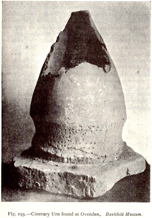
“On digging about 2ft (61cm) below the surface of the ground, a slab of stone impeded the work, and on its removal, a square cavity, formed of four upright stones, was discovered, in which the urn had been placed bottom upwards (see old photo, PB), and the mausoleum filled with gravel… The urn had not been disturbed since its removal from its present site, but still remains on its original base: a rude stone which formed the floor of its ancient sepulchre.  The urn measured when first discovered 19in (48cm) in height by 13in (32.5cm) in diameter at its orifice, but only 4in (10.2cm) at its base.  Below its rim it has the usual curved division which is here ornamented with dots made with a pointed instrument when the clay was in a soft state.”

Mr Roth went on to tell how a Dr Dolan of Halifax examined the broken bones and contents within the urn and found them to be human.  Intriguingly it seems there was some evidence of prehistoric dental practice from the remains!  Dr Dolan told:

“There is unmistakable evidence on this point from some of the bones of the skull, particularly from the preserved portions of the petrous part of the temporal bone showing meatus auditorius, from the right malar bone, and from fragments of the flat bones of the cranium.  The teeth offer confirmatory evidence.  I have found several which had evidently been subjected to great heat, as they were completely calcined.  But there was one which had been only partially burnt, the burnt part being quite black; and another, unburnt, which seems to have dropped from the jaw before the fire had reached it.  One of the teeth seems to me to have been ‘stopped’, and this opens out a question  whether the art of dentistry was known to the inhabitants before the Roman invasion.  From the size and structure of the bones, I believe the majority of them to have belonged to a female of adult age.  There are certain bones, particularly some phalanges, which seem to me to be those of a child.  As we do not however possess the whole of the original contents of the urn — much having been extracted from it on its discovery — there may probably have been, when first interred, the relics of others than those we at present possess.”

The remains of the urn were eventually presented to the care of the Bankfield Museum by the Halifax antiquary, F.A. Leyland.

A definitive account of this little-known site was recently published by Raymond Varley (2021), and all interested readers can refer to his work here.

References:

  1. Bennett, Paul, Circles, Standing Stones and Legendary Rocks of West Yorkshire, Heart of Albion Press: Loughborough 1994.
  2. Leyland, F.A., The History and Antiquities of the Parish of Halifax, by the Reverend John Watson, M.A., R.Leyland: Halifax n.d. (c.1867)
  3. Roth, H. Ling, The Yorkshire Coiners, 1767-1783; and Notes on Old and Prehistoric Halifax, F.King: Halifax 1906.
  4. Varley, Raymond, “A Large Bronze Age Collared Urn found at Mount Zion Chapel, Ovenden, near Halifax, West Yorkshire,” Academia 2021.
  5. Watson, Geoffrey G., Early Man in the Halifax District, HSS: Halifax 1952.

© Paul Bennett, The Northern Antiquarian


The Carrs, Ovenden, Halifax, West Yorkshire

Enclosure:  OS Grid Reference – SE 0555 2993

Also Known as:

  1. Rough Carrs

Getting Here

Aerial view of enclosure & outlying earthworks

Troublesome to get to if you don’t know the area. You can get here rom Halifax, up through Highroad Well towards Wainstalls, keeping to the road that leads to the Oxenhope windmills.  A short distance before the windmills, as the road levels out, keep your eye out on the right where the valley drops down (east) to the Halifax golf-course.  If you’re coming from Oxenhope, walk up past the windmills at Nab End until the road starts going back downhill.  As you look down and walk past the valley with the golf course in it, a footpath is on your left running diagonally over a field.  Cross the stile and walk alongside the wall for about 200 yards until you reach a gate on your left.  Go through this and walk along until you see the ditched earthworks that make up this little-known monument…

Archaeology & History

Not to be confused with the large circular enclosure that once crowned the nearby Hunter Hill, the nature and age of this large D-shaped earthwork has long been a source of speculation, with the majority of it centring around a Roman origin — and for good reason, it has to be said!

NW section of earthworks
Southern section of ditch

More than 280 yards (260m) in circumference, its north-south axis measures 82 yards (75m) at the greatest and 88 yards (81m) east-west.  Its main feature is a decent ditch that averages 8-10 feet across round most of the D-shaped feature, and between 2-3 feet deep.  It would obviously have been deeper than this when the ditches were first dug, but it’s now very overgrown across the entire site with Juncus grasses and tribbles (tussocks). A small internal ditch runs into the enclosure from the northern side.  Its function is unknown.  A small mound near the centre of the site has been posited by Calderdale archaeologists to be modern remains.

Carrs enclosure on 1852 map

Although the main feature is the D-shaped earthwork, other features are apparent.  For example, what looks like another man-made dyke cutting into the site on the southwestern side is in fact a natural stream channel.  This natural feature may have been an integral part of the enclosure when it was first built.  Above the northwestern edge of the ditch (as can be seen on the aerial photo) are other earthworks that run around the western edge of the main feature.  This is probably what F.A. Leyland (1867) meant when he described there to be “the remains of several lines of intrenchments” here.  Also coming into the southwestern side are what are thought to be the remains of a Roman Road.  Early OS-maps (above) show the road running within yards of this enclosure — and it was this which, logically, led many earlier researchers to posit the notion that this site was in fact Roman.  However, a dig here in 1951 recovered prehistoric pottery, which knocked the date back to the Iron Age.

Northern line of ditch

On the south and east sides, parts of the ditch and embankment have been removed by quarrying and farm-workings, with the walling on the eastern side completely ruining that part of the monument.   A great number of flints have been found on the hills above here.  I’m unable to give a more detailed exposition on the archaeological finds at this site as I don’t have a copy of Mr Varley’s (1997) essay that he wrote for the Transactions of the Hunter Archaeological Society, which apparently gives more info.  When I manage to get a copy of the journal/essay, I’ll add the relevant data to this profile.

A note must also be made of another, previously unrecognized enclosure on the same hilltop a couple of hundred yards to the west from here.  Very little trace of it is still visible at ground level, but the outline of the curvaceous quadrilateral ditch form can be seen from the air.  It would appear from its form to be consistent with an Iron Age enclosure, though without further research this has to be proclaimed as hypothetical.  No excavations are planned here in the near future.

Folklore

In F.A. Leyland’s (1867) superb commentary to Mr Watson’s History of Halifax, he told us:

“There is a well-preserved tradition amongst the inhabitants that a battle in which numbers fell was fought at a place called the Slaughters or Slaughter Gap, in the hollow between the Carrs and Hunter-hill.  Fragments of gun-barrels and locks, with human bones, have been found about the place…”

But Leyland deemed the armoury finds here — that appeared to substantiate the folklore — were from a much later period in history than the enclosure.  But I must draw attention to the remarkable Mixenden Finds, as they’ve become known: a collection of finely polished prehistoric axes and other stone remains a few hundred yards below The Carrs and which may relate to such folklore.

References:

  1. Leyland, F.A., The History and Antiquities of the Parish of Halifax, by the Reverend John Watson, M.A., R.Leyland: Halifax n.d. (c.1867)
  2. Varley, Raymond, “The Excavation of Castle Stead at Manywells Height, near Cullingworth, West Yorkshire,” in Transactions of the Hunter Archaeological Society, volume 19, 1997.
  3. Varley, Raymond A., “Lost Neolithic and Bronze Age Finds from Mixenden, near Halifax, West Yorkshire,” in Yorkshire Archaeological Journal 70, 1998.

© Paul Bennett, The Northern Antiquarian