Cup-and-Ring Stone (lost): OS Grid Reference – NY 5019 2776
Also Known as:
Archaeology & History
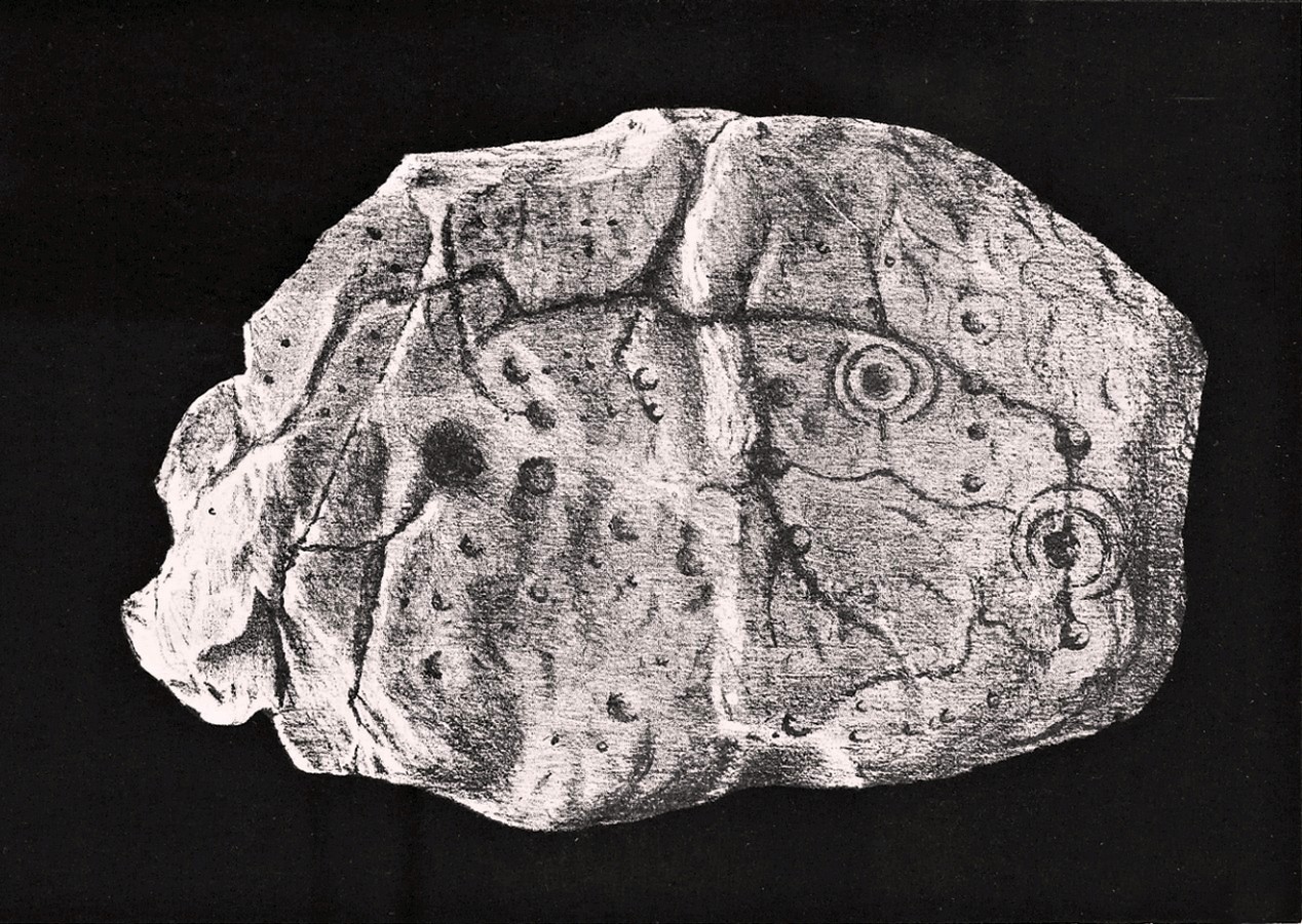
Taylor’s 1883 sketch
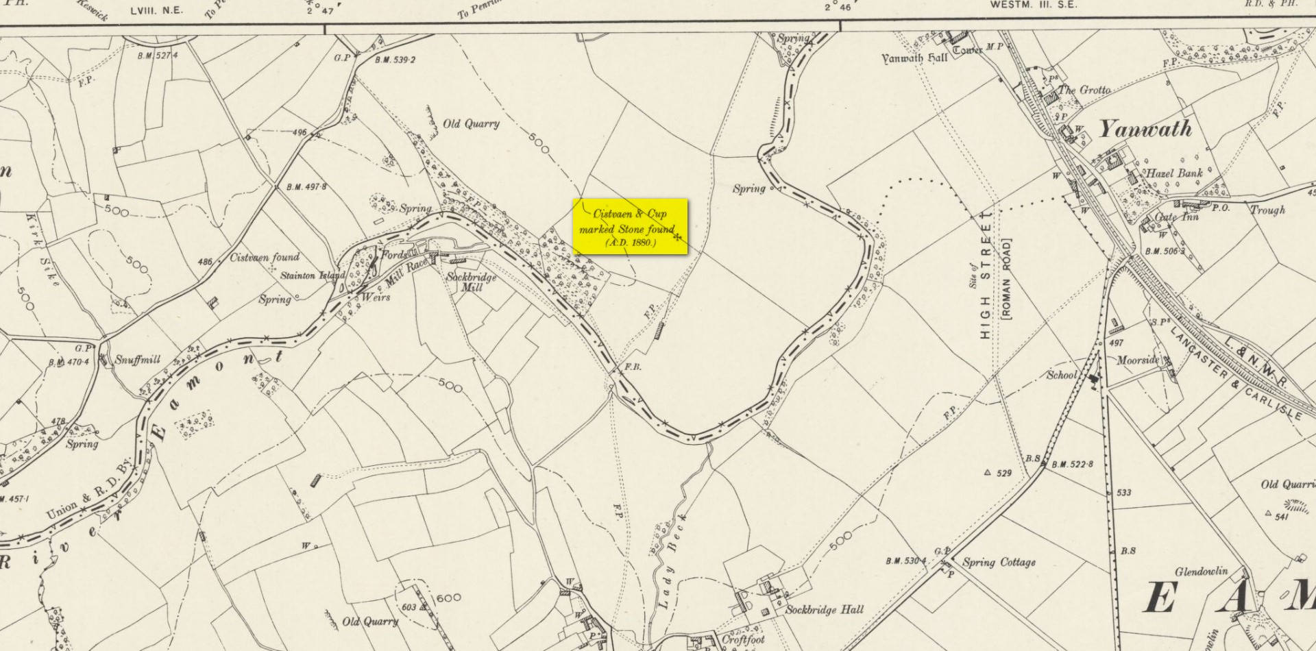
The geographical position of this site was shown on the 1897 Ordnance Survey map, albeit in the past tense as it had been destroyed not long after after being uncovered. Thankfully however, local antiquarian Mick Taylor (1882; 1883) did a damn good job recording what had been found here, and although he had remains of the stone in his possession shortly after it had been found, the carving has subsequently been lost. Thankfully Mr Taylor left us with a good drawing of the design (right).
Located a short distance west of the grand henges of Mayburgh and King Arthur’s Round Table, the carving was found some ten inches below the ground during work that was being done to lay some new fencing. The lads doing the work hit some stone and found it to be covered with a number of standard cup-and-ring motifs facing downwards. This carved stone, wrote Taylor (1882), was in fact “the cover of a kist-vaen”, a.k.a, prehistoric stone burial cist. He then proceeded to give a lengthy account of the site and the carving, telling:
Site shown on 1897 map
“There are traces of ancient occupancy, and vestiges of cairn structure still to be discerned on the hill-side on which it was found, but no barrow nor mound covered this particular grave. A space had been excavated for the interment dipping into the limestone rock to a depth of about 3 feet; the length of the grave was 4 feet, and the breadth about 3 feet 6 inches. Cobble stones had been used partially to line the cavity, but there was no flagging at the sides or bottom. The space was filled with blackish soil, amid which was a quantity of burnt bones, all in a fragmentary state. No implement nor shreds of pottery could be found, but there were several pieces of charcoal. It had evidently been an interment of cremated remains.
“The massive stone which formed the cover of the kistvaen I saw in situ immediately after its discovery.
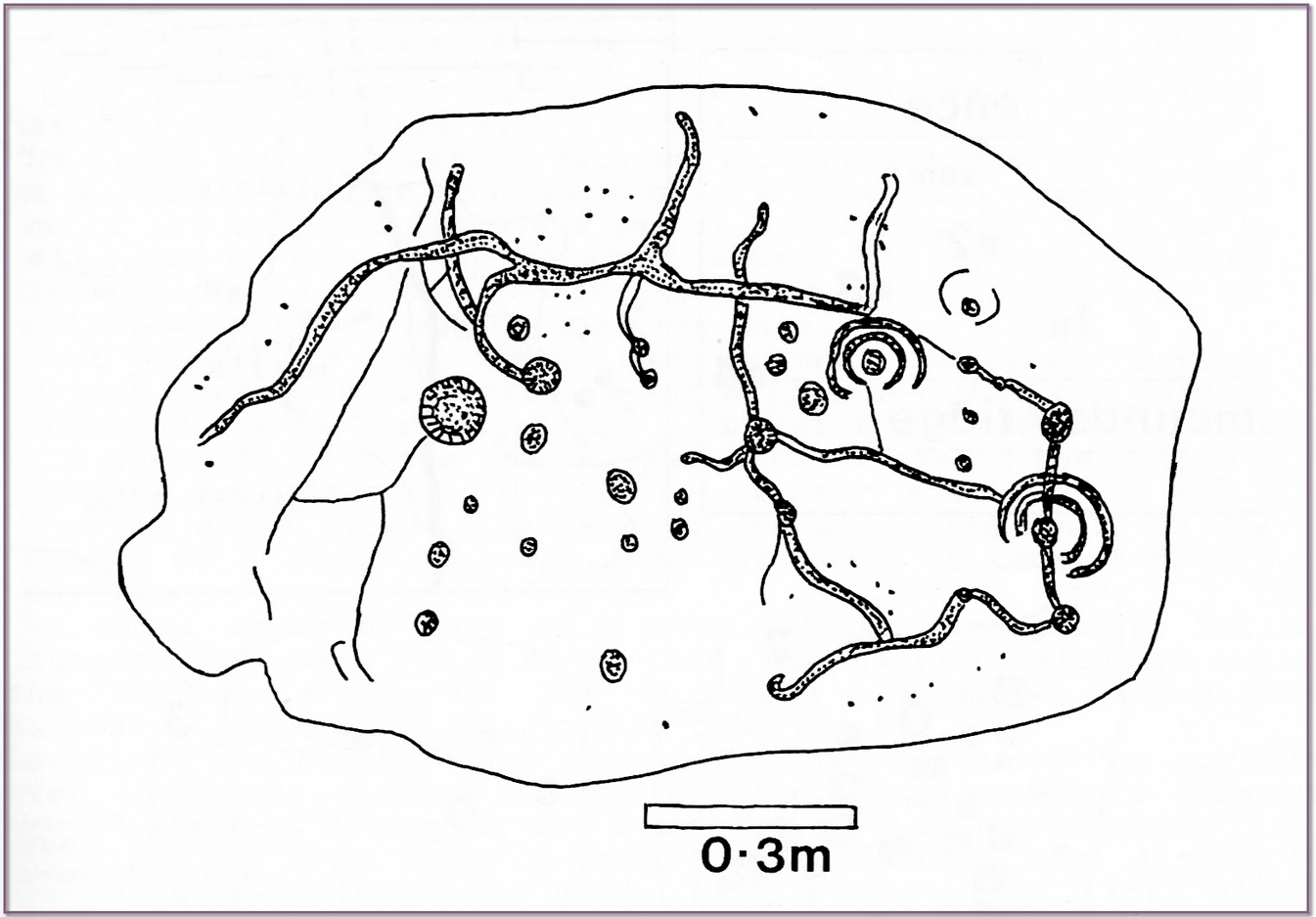
Beckensall’s impression of the design
“This stone is a natural slab of white freestone; it is of a broadish ovoid form, 5 feet 4 inches long, and at the centre 3 feet 6 inches broad, tapering towards each end; and it varies from 8 inches to 13 inches in thickness. The superior surface is rough and irregular, and scored in many places with marks of the ploughshare and harrows, which have passed over it in frequent cultivation. The interior surface, which was presented towards the grave, shows a fairly smooth cleavage, and on it were carved the sculptured markings which I shall describe.
“The slab, which is in my possession, was unfortunately broken in three or four pieces by the hammer of the workman, but I have put it together, and when viewed with a certain light when the shadows are deep, the sculpturings may be well made out, and appear to be arranged as follows: near the bottom there is a central cup deeply carved, about 3 inches in diameter; around this there are two concentric rings, somewhat faintly incised, the outermost of which has a diameter of 6 inches. From this central cup proceed two grooves 6 inches long, which bisect the concentric circles, and traverse in a straight line to join a similar cup on each side of the central one. From this line of cups three gutters meander upwards over the surface of the slab; the main channel takes a direction upwards on the right side of the stone, and receives a number of branches like the tributaries of a river from each side, and terminates on the free margin of the upper part of the stone. On the lowest quarter of the stone to the right there is a large hollow cup 3 inches in diameter, around which also there are two well-executed concentric rings, the largest with a diameter of 6 inches. These rings are cut by a radial groove which joins a gutter in the centre of the stone, and in the opposite direction, at a point in their circumference, they fall into and are subtended by the larger side channel. These are the only two cuttings on the stone which present this annular arrangement; on the other hand, the simple cup markings are numerous, in fact, twenty-four may be counted. One of these cups is greatly larger than any of the rest. It is situated in the centre of the upper half of the slab, and on first view forms the most strikingly characteristic feature of the tablet. This cup is 6 inches in diameter, and is carved out to the depth of 3 inches. The chisel marks are distinct and fresh, as if done yesterday; and there is a smoothness and regularity of execution about it, which evinces that more pains have been taken with it than with some of the other incisions. The other cup-markings vary from 1 inch to 3 inches in measurement. A number of them (about twelve of them may be counted) are associated with the furrowed lines, either forming the beginning of a gutter, or joining or being included in the line of the channel itself. These form the series of the larger cup-markings, and are an inch or more in depth. On the other hand, others of these cups are isolated, and scattered singly, and apparently without regular order over the surface, and unconnected with the branch-like lines; these for the most part are mere shallow depressions, and with less defined margins. Again, there is another class of markings on the stone; they are very numerous, and are dispersed apparently irregularly over all the surface; these are little pits or pick marks, small irregular holes picked into the stone, evidently done with some pointed tool.”
Taylor thought that these “small irregular holes” had been made with a flat-edged chisel whacked with a hammer, and the cup-marks “by a flint or harder stone.” In examples I’ve found in Perthshire where the tools have been left at the site, both a harder stone was found at one (for some reason actually laid within the cup-mark and left there before it had been finished), whilst a flint was laid in the cup-mark of another carving (although that example seemed to be more a deliberate deposit rather than being the tool that made the carving).
Anyhow, considering the poor condition of the carving when Taylor described it—”broken in three or four pieces”—there’s little likelihood of it having survived. But, on the off-chance that someone’s mum or granny has it hiding in the rockery at the back of the garden somewhere, give us a shout….
References:
Beckensall, Stan, Cumbrian Prehistoric Rock Art, Abbey Press: Hexham 1992.
Beckensall, Stan, Prehistoric Rock Art in Cumbria, Tempus: Stroud 2002.
Taylor, Michael W., “On a Sculptured Stone with Cup and Ring-Markings, found at Redhills, near Penrith,” in Proceedings Society of Antiquaries Scotland, volume 16, 1882.
Taylor, Michael W., “On a Cup-marked Stone found at Redhills, near Penrith,” in Transactions Cumberland & Westmorland Antiquarian & Archaeological Society, volume 6, 1883.
Acknowledgements: Huge thanks for use of the Ordnance Survey map in this site profile, reproduced with the kind permission of the National Library of Scotland.
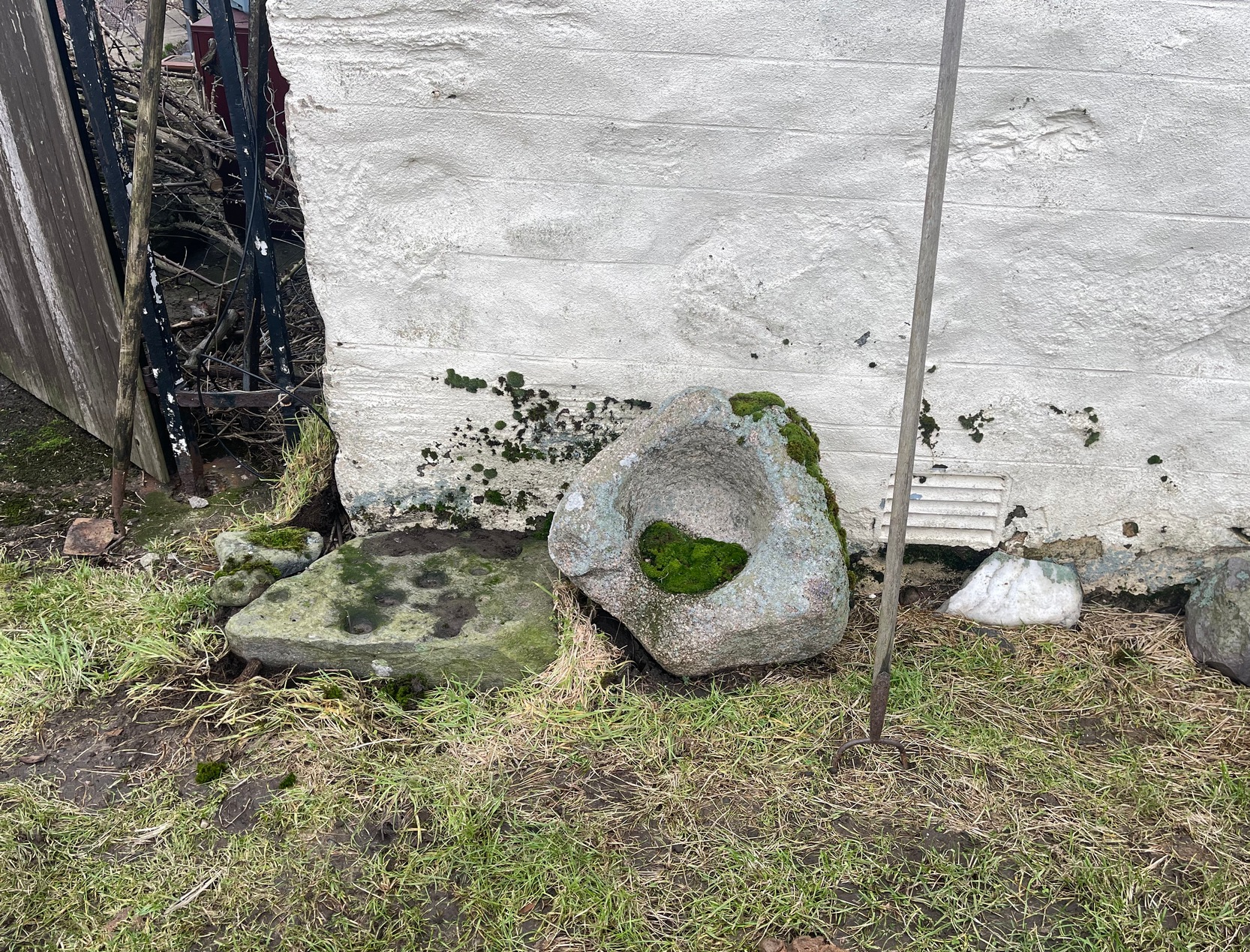
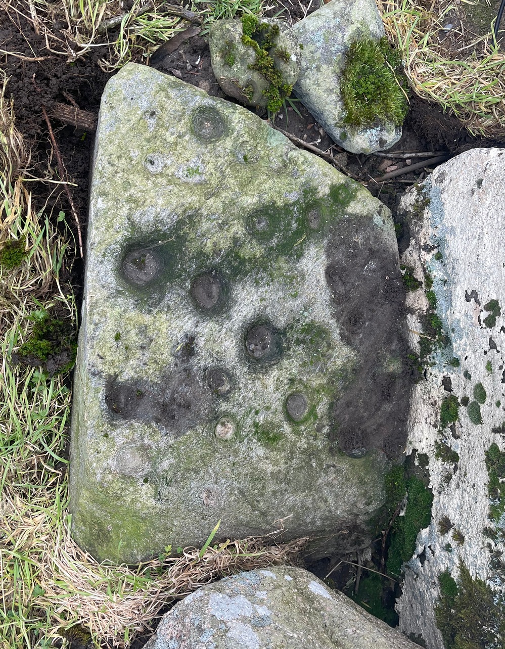
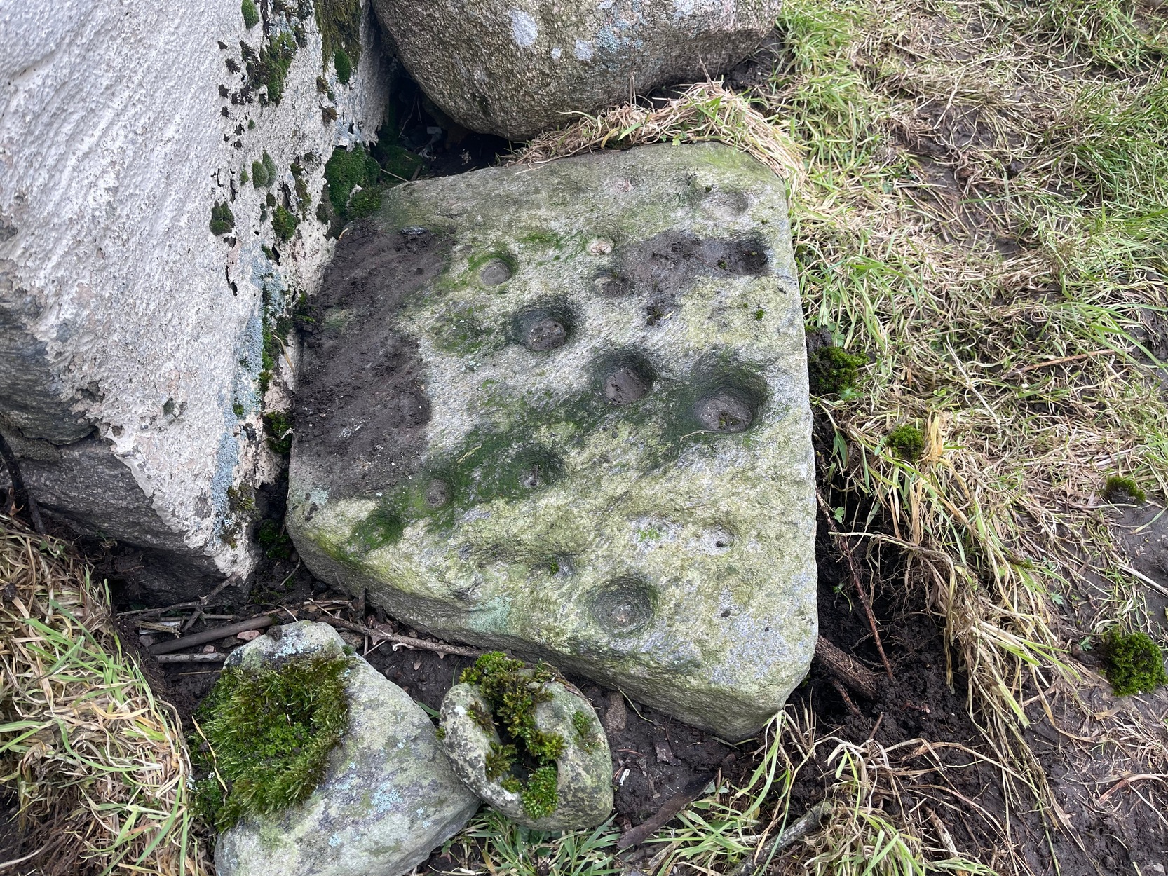
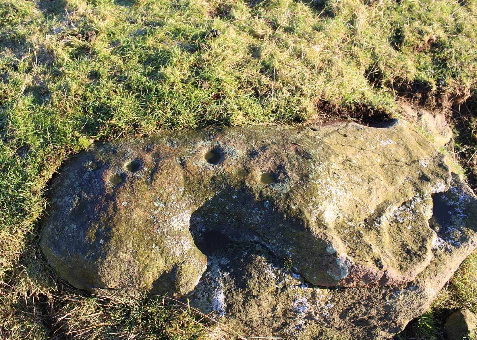
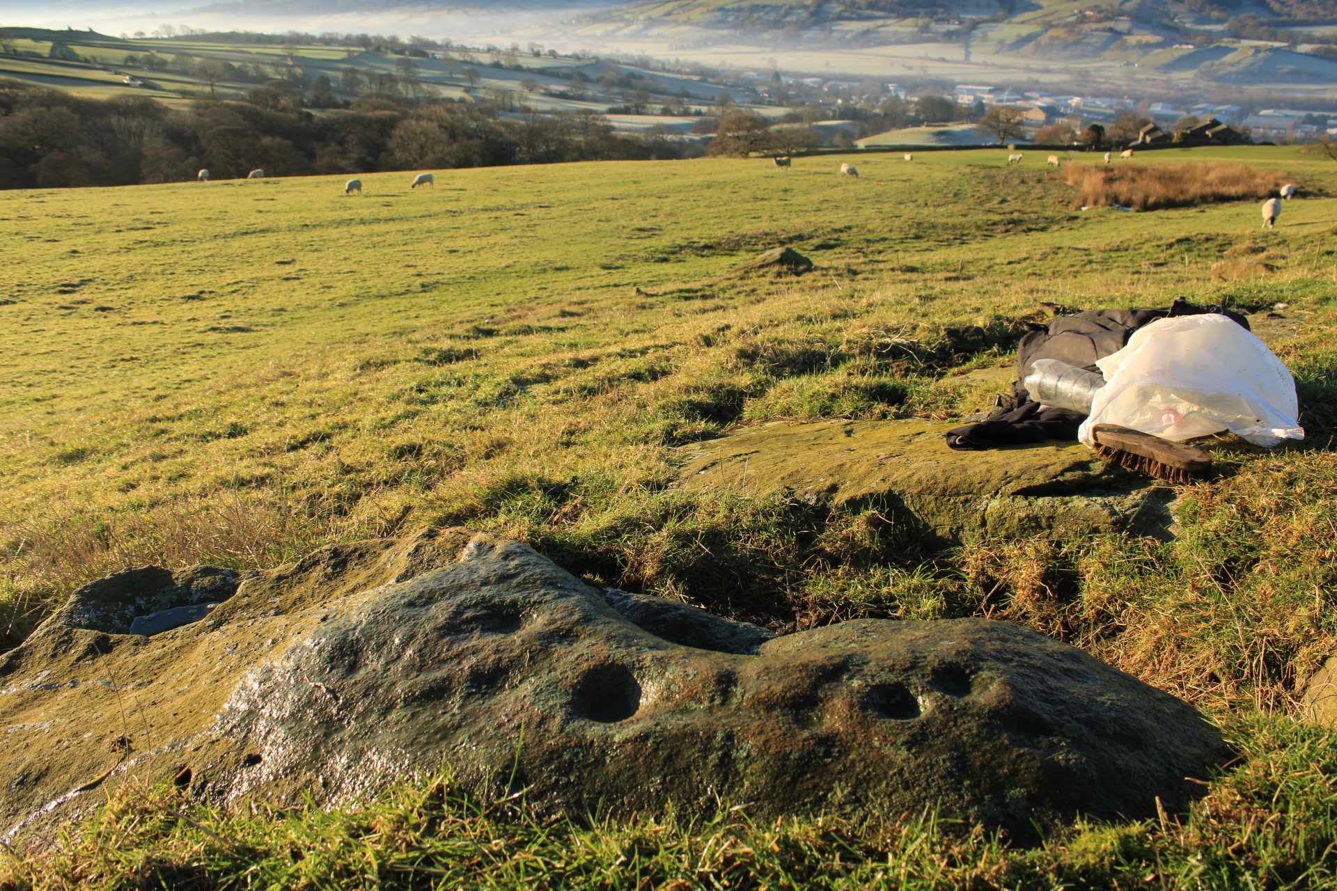
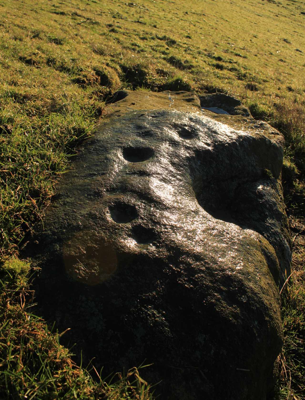
From Blair Atholl village along the B8079 road, take the minor road signposted to the Bridge of Tilt and go all the way to the top, taking the same directions as if you’re visiting the large prehistoric cairn of Monzie. As you walk towards Monzie farmhouse, you need to look at the large end-facing wall and on the ground at the bottom-left corner you’ll see this old cup-marked stone, next to an old bullaun. It’s probably polite to knock and ask the farmer—who we found to be very helpful indeed. (huge thanks fella!)
Archaeology & History
This is an intriguing carving, inasmuch as its present habitat isn’t it original home. When we visited the old stone recently, the farmer was very helpful and told us what he knew of it, which was, he said, “not much.” In pointing out where it had originally come from, he pointed south, “past the fields – somewhere over there. My dad knew about it,” he told, and thought that he may have been the one who found it. Anyhow, it was his dad who brought it to the place where it now sits: right up against the edge of the house on its southeast corner.
“It looks like it might have come from a tomb,” I said, but he didn’t know about that. The giant cairn in the fields past his farmhouse certainly wasn’t where it had come from. Quite the opposite direction… And so it transpired when I looked at the very menial archaeological notes that have been written about it.
When archaeologist Margaret Stewart noted the carving in the 1960s, she told how the stone had reportedly been found in 1953 by the ruined lime-kiln (NN 9052 6672), just above the western shore of Loch Moraig. But what she didn’t know was that the lime-kiln was built at the edge of the prehistoric tomb that was known to local people as Carndeshal, or Cairn Deshal. The word deshal means sunwise, or the direction taken by the sun, clockwise, as in the word deosil. It is usually associated with a ceremonial procession. The cup-marked stone probably came from this cairn when it had been demolished and was thankfully saved by the farmer.
Altogether there are 24 or 25 mainly well-defined cup-marks on this thin slab, covering most of the surface. In a couple of places on the stone, two of the cups are conjoined. There are apparently no cup-marks on the other side of the stone.
Acknowledgements: To my awesome Naomi – for getting us up here.
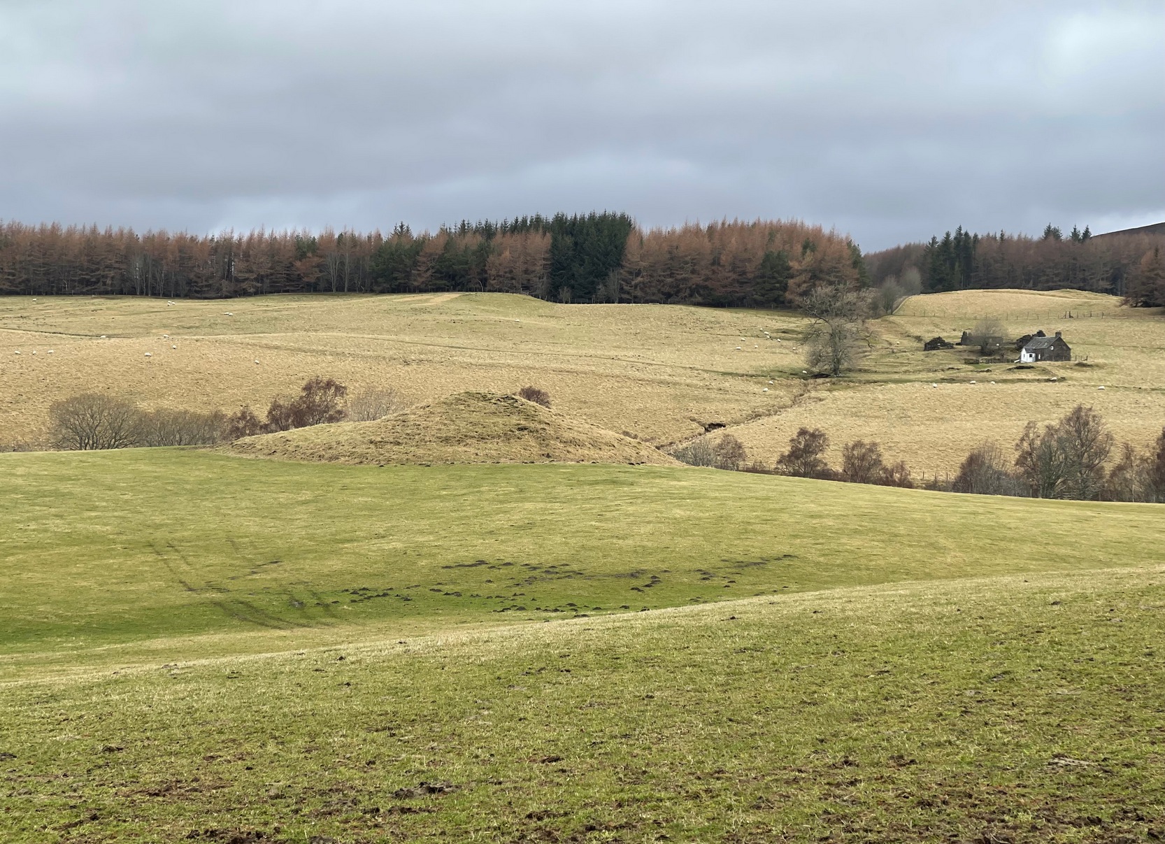
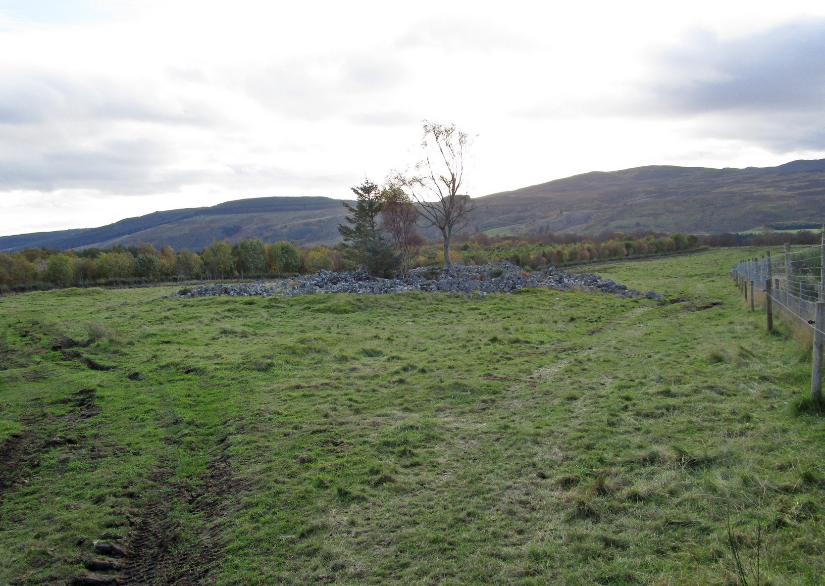
Along the B8079 road in Blair Atholl village, take the minor road signposted to the Bridge of Tilt. After half-a-mile, where the road splits, keep to the right and head further uphill and, where the almost-track-like road splits again another quarter mile up, bear to the right again and just keep going uphill for nearly two miles until your reach the large car-park on the left. Park here and then take the dirt-track to the farm (truly friendly helpful folk) where, in the field to the rear of the buildings, a large unmissable mound rises up!
Archaeology & History
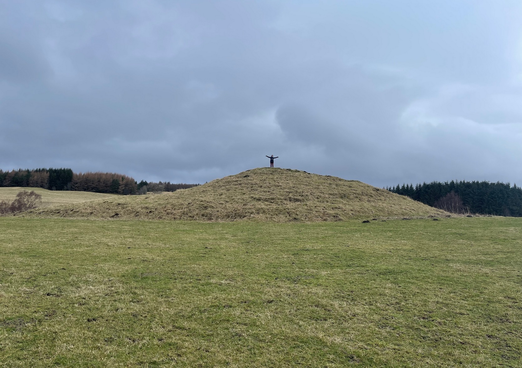
This is a bit of a beauty! Hiding away on the southern edges of the Cairngorms we find this huge archetypal burial mound, 35 yards across and all but covered nowadays in deep layers of soil. But it looks good. When you walk onto its crown, about twelve feet up, you see and feel beneath you the scattered mass of small rocks and stones that comprise the monument as a whole, from top to bottom. On its south-western side, the cairn is lower and elongated: this is due, on the whole, to where field clearance stones were pushed up against the monument many decades ago, making that side of it look bigger than it originally was.
Naomi on top for size!Monzie cairn, looking W
Curiously perhaps, no archaeological attention of any worth has been give to the site apart from the usual estimates of its size and a guesstimate of it being neolithic or Bronze Age in nature (an easy thing to suggest). On top, just beneath the grasses, is what may be the section of a small cist, but this may just be a fortuituous formation. Excavation is required! It’s one of a small number of old cairns and tombs in this locale, but this seems to be the biggest — unless, of course, the lost but legendary Carn Deshal, less than a mile to the south, stood larger…
Acknowledgements: To my awesome Naomi – for getting us up here.
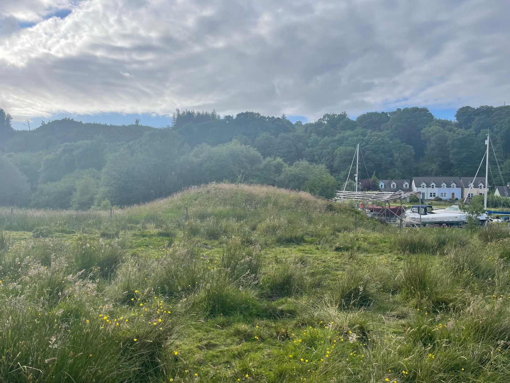
Take the A816 out of Lochgilphead and head north as if you’re going to Kilmartin. Nearly 2 miles along, take the left turn along the B841 Crinan road. A few hundred yards along, go over the canal bridge and about 70 yards along there’s a left turn onto the track into the Knapdale Forest. Go along here (there’s a parking spot) for 200 yards until your reach the grasslands on your left. If you walk into this bit of scrubland, you’ll see the rounded fairy-mound over the fence in the adjacent field, almost overlooking the canal. Y’ can’t really miss it.
Archaeology & History
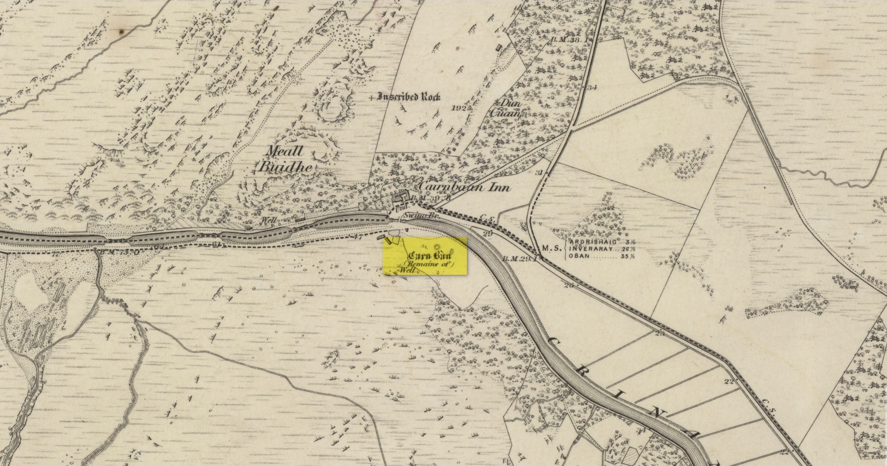
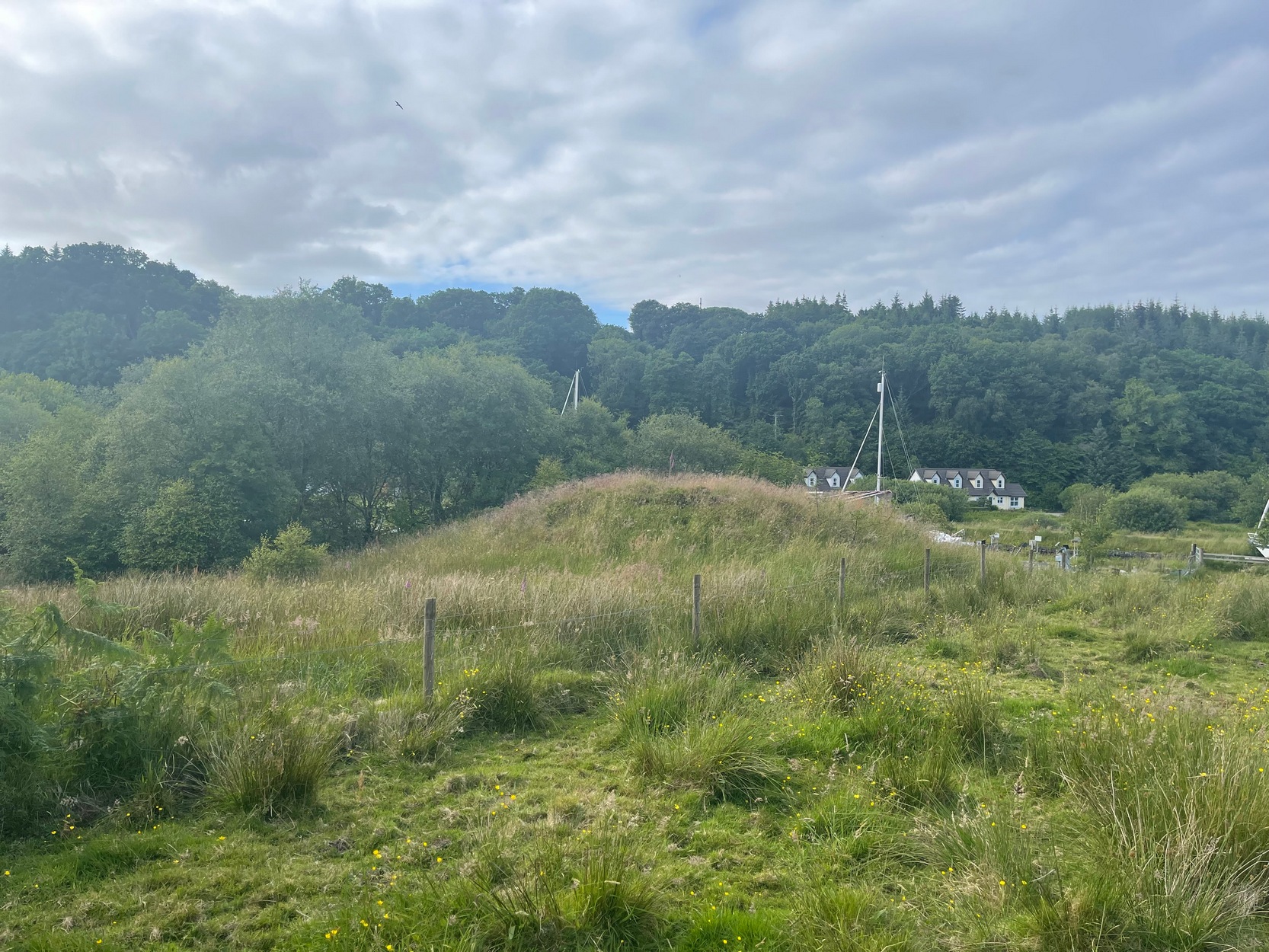
Carn ban, or the White Cairn, from which the hamlet of Cairnbaan gets its name, is a good-sized round cairn, now much overgrown in vegetation, though is still accessible and easy to see. Just above the water-line of the Crinan Canal, the mound is about ten yards across and more than six feet high and is in a good state of preservation. Originally, according to J.H. Craw (1930), the tomb was 12 feet high and 40 feet across!
Carn Ban on 1873 mapCarn Ban, looking NE
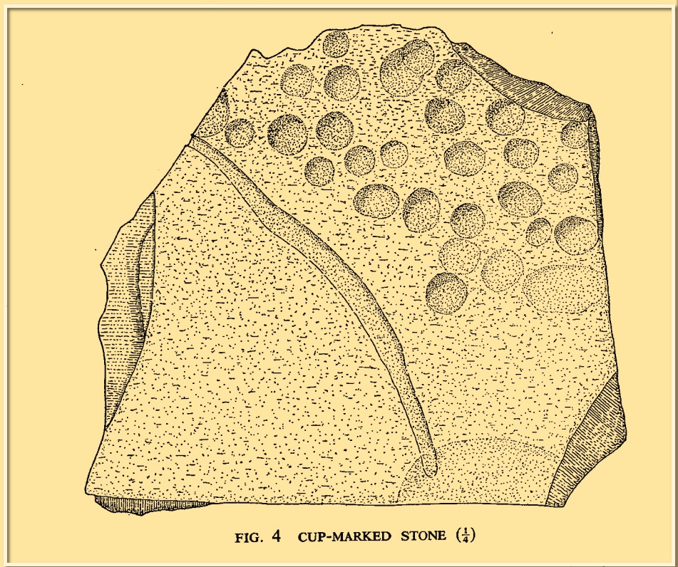
In the 1850s, the site was examined by a Dr Hunter of Lochgilphead, and Mr Richardson Smith of Achnaba, and a cist that had been built straight on top of the bare rock was uncovered near the centre of the cairn, nearly four feet long and aligned northeast to southwest. Inside it a thin slab of stone—“2 feet long, 17 inches broad, and 2½ inches thick”—had been slid up against the western end of the chamber and on it was a curious petroglyph design comprising “several incised diamond-shaped figures, one within the other”—five altogether, and the commencement of a sixth—similar to ones found at Newgrange in Ireland. This carving was removed and given to the Scottish National Museum where it still resides. Inside the cist, Hunter and Smith found a deposit of some “yellow sand with some black charcoal and several burnt bones lying upon its bottom”, and a subsequent search unearthed some flint fragments.
The Carn Ban is a good site—but if you’re wanting something bigger, something more impressive, I suggest heading just a few miles north…
References:
Beckensall, Stan, The Prehistoric Rock Art of Kilmartin, Kilmartin Trust: Kilmartin 2005.
Simpson, James, Archaic Sculpturings of Cups, Circles, etc., Upon Stones and Rocks in Scotland, England and other Countries, Edmonston & Douglas: Edinburgh 1867.
Acknowledgements:Huge thanks for use of the Ordnance Survey map in this site profile, reproduced with the kind permission of the National Library of Scotland.
From Bainbridge, take the A684 road east to Aysgarth. Just out of the town, 200 yards over the bridge, take the right turn down Blean Lane. Nearly ½-mile along, take the minor road on your left and go along here for 1½ miles where, a few hundred yards before the solitary farm of Carpley Green (lucky buggers!), you can park up. (keep plenty of room for a tractor to get in the fields) Walk down the track past the farm and 250 yards along, where the first field ends, a gate leads you into the hills on your left. Go through here and then the next gate 120 yards on, then walk straight along th elong geological ridge ahead of you, veering to the top-side until it meets the walling. You’ll see the giant Stoney Raise cairn on the other side.
Archaeology & History
Stony Raise from above
The remains we find here are nigh-on immense! If giant cairns get you going (like the Great Skirtful of Stones or the denuded Devil’s Apronful near Pendle, etc), this one will blow you away! Along its widest axis, to this day it’s nearly 40 yards across and nearly 7 feet high! But in earlier times it was even bigger—much bigger! The first known description of the site was made by one Charles Fothergill, a Yorkshire-born politician and ornithologist, who wrote a diary of his walking excursions to various places in North Yorkshire at the beginning of the 19th century. (Romney 1984) His account of it was a good one for that period and thankfully he recorded information that would otherwise have been forgotten. After his visit here in September 1805, he told about this,
“wonderful tumulus called Stone raise which is a great curiosity: it is formed entirely of large stones piled up without earth or gravel, differing in that respect from any I have seen. Notwithstanding that upwards of a thousand, nay ’tis said several thousand, loads of stones have been led away from it to build walls with, it yet remains a stupendous monument of this species of antiquity: we measured the base of it as well as we could by our strides and made it 369 feet in circumference and of such an height as to be seen for a considerable distance. It has been most completely rifled…and it now presents a number of small craters formed by the investigations of the money searchers. It is situated upon a hill about half a mile south of Addlebrough. In addition to the particulars I formerly mentioned, I may say the men who first opened it about 50 years ago worked incessantly for 33 days. It stands on Thornton moor, and tho’ the Thornton men would not assist in the labour, they intended to share in the profit if there was any; but the adventurers who had all the work resolved they should not and they carried a large sword with them every day to defend the treasure in case they found any; the wise man who read ’till the stones shook and rattled was a schoolmaster at Bainbridge: the teeth they found were deposited in a hollow place in the bottom of the tumuli formed long and narrow like a coffin by a walling of stones. Tho’ the tumulus has apparantly been compleatly rifled, I do not believe the whole base has been sufficiently searched, but if it was to commemorate one great individual, which appears to have been the case, perhaps nothing more may be found.”
Fothergill’s description of “upwards of a thousand” cartloads of stone being removed from Stony Raise has been doubted by some archaeologists, but this claim should not be dismissed so lightly without evidence. There are immense tombs from northern Scotland to the unholy South that have remained untouched by the hand of industrialists that easily enter the category of such giants and this may have had equal stature.
A few years after Fothergill’s visit, Thomas Whitaker (1823) briefly described the site in his magnum opus, but added very little, simply telling that on the hills behind Addlebrough,
“there is still on that elevated spot a cairn, called Stone Raise, about 120 yards in circumference at the base, to which the usual tradition of its containing a treasure of gold having been attached, two persons were several years ago induced to make the experiment; but having penetrated to the centre, found, to their great disappointment, what an antiquary would have prepared them to expect, namely, a kist vaen of flag stones, with the remains of a human skeleton, the teeth of which were still pretty perfect.”
To this day the site remains unexcavated, so we don’t know too much about the place. It’s likely to have been constructed in neolithic times and its ancestral nature quite obviously venerated. It may have been re-used during the Bronze Age, but without excavations we may never know. A decent dig into this site is long overdue!
Folklore
This gigantic tomb is, not surprisingly, said to be haunted. Strange sounds and visions have been encountered here in bygone times. But the most well-known tale is that it was the site of a great treasure—perhaps hinted at by Fothergill. There are variations on the theme, but this is overall story:
Structured stonework
The tomb was said to be where a local giant had fallen and with him was buried a great chest of gold which he had dropped before he died. Some say that the ‘giant’ was a Brigantian chief – others a great warrior. The great treasure chest beneath the cairn is said to be looked over by a fairy who once lived by the giant’s tomb. It was this tale which gave the site its local name, the ‘Golden Chest on Greenber’. Several attempts have been made to find the treasure, but all have failed.
However, when the roving antiquarian Edmund Bogg came to write of the place in 1908, the giant had by all accounts been found within! He told us that,
The giant’s cist cover?
“this Kist-vaen was opened, many years back, and the skeleton of a chieftain of great stature was unearthed; the treasure chest of that or some other primal savage was not, and has not yet been discovered – for, take heed ye matter-of-fact money hunters, it is said the lucky one must first see the wraith of the ancient warrior to whom it belonged, who will then shew under which part of the immense Raise it is hidden! May this help any reader who is imaginative enough to find it – having seen the wraith he must keep silence – he has then but to stretch out his hand, and draw it forth.”
There are variations on this tale that have subsequently been penned by a number of Yorkshire folklorists, but this is the general lore. There was also a short rhyme told of Stoney Raise, that speaks of its apparent use through history by various races:
Druid, Roman, Scandinavia,
Stone Raise in Addlebro’.
References:
Bogg, Edmund, Wensleydale and the Lower Vale of the Yore, E. Bogg: Leeds 1906.
Bogg, Edmund, Richmondshire, James Miles: Leeds 1908.
Elgee, F. & H.W., The Archaeology of Yorkshire, Methuen: London 1933.
Gutch, Mrs E., Examples of Printed Folklore Concerning the North Riding of Yorkshire, David Nutt: London 1899.
Lofthouse, Jessica, Countrygoer in the Dales, Hale: London 1964.
Parkinson, Thomas, Yorkshire Legends and Traditions – volume 2, Elliot Stock: London 1889.
Pontefract, Ella, Wensleysdale, J.M. Dent: London 1936.
Romney, Paul (ed.), The Diary of Charles Fothergill, 1805, Yorkshire Archaeological Society: Leeds 1984.
Whitaker, Thomas Dunham, An History of Richmondshire – volume 1, Longman Hurst: London 1823.
White, Robert, A Landscape through Time, Great Northern: Ilkley 2002.
Cup-Marked Stone (lost): OS Grid Reference – NU 2299 2989
Archaeology & History
Tait’s 1971 sketch of the carving
When the Beadnell Caravan Park was being constructed in 1970, in cutting into the Earth the workmen destroyed a couple of prehistoric tombs—but not before one of them (the northernmost one of the two) was thankfully excavated. It was looked at by John Tait (1971), who described the covering cairn as measuring “nineteen feet in diameter and four feet high”. Beneath it, within a cist that had been modified at two very different periods in time, were a large number of human remains that had been deposited over equally extended periods, suggesting it was a place of considerable importance to either one family lineage or the tribal lineage (unless it was just a dumping spot for any old Tom, Dick and Harry!). Outside of the cist itself, but within the rocky mass of the cairn, this cup-marked stone was found (illustrated). It had already been moved by the workmen before Tait came to excavate it, so he was unable to ascertain its precise position in the tomb. Carved into a piece of sandstone were a number of odd-sized cup-marks, smaller than usual. Tait wrote:
“It measures 38cm by 36cm and bears 29 small cup-marks and one slightly sinuous duct leading into what may be part of an earlier and larger cup. It also seems probable that additional cups were added in antiquity, since some are distinctly more shallow than others and, in one instance, two cups impinge upon one another. The stone had been broken in antiquity and may have come from a larger inscribed slab, as is perhaps the case with some other “portable” stones of burials or cairns and other monuments of the second this nature.”
It is thought that the carving was laid back in the ground whence it was found.
References:
Beckensall, Stan, Prehistoric Rock Motifs of Northumberland – volume 1, Abbey Press: Hexham 1991.
Beckensall, Stan, Prehistoric Rock Art in Northumberland, Tempus: Stroud 2001.
Cist (destroyed): OS Grid Reference – NS 872 825 (approximation)
Antiquarian Notes
Writing in the “Transactions of the Stirling Natural History & Archaeological Society” in 1882, Mr Thomson told:
“About the middle of last month I was informed by Mr Bruce that the Council of the Field Club had asked the rector and myself to go and examine a cist alleged to have been discovered in a field near Stenhousemuir. I arranged with the rector to go the following Saturday. As he was suffering from cold, and it was stormy, he was unable to go. I thought I would risk cold and storm, and at the station met Mr Taylor of Morrison & Taylor, who was just returning to Larbert. Learning my errand he kindly promised me every assistance. During tea Miss Taylor procured for me the account of the opening of the cist which had appeared in the Falkirk Herald. It ran as follows:
“‘Discovery of Human Remains – On Tuesday last, the workmen employed by the Carron Company in excavating the Sand Hills, about a quarter of a mile to the south of the village of Stenhousemuir, made a discovery which has caused some excitement in the district. At the depth of four feet from the surface the workmen came in contact with a stone coffin or grave, 3 feet 9 inches long by 2 feet broad, very substantially built, and containing the remains of a human body. When the discovery was made, parts of the skull were in good preservation, but soon after being exposed to the air they crumbled away. The remains have been carefully collected, and are now in possession of the workmen at the hut at the Sand Quarry. On Wednesday a great many people visited the place, prompted by a natural curiosity to see these relies thus suddenly brought to light, the history of which, it is to be feared, must ever remain a mystery. ’”
“After tea, Mr Taylor and I went to the place where the cist was railed off. It is in the middle of a field acquired by the Carron Company to take sand for their castings from, and the excavation that revealed the cist had been made with a view of getting a new bed of sand. About 200 yards west of the gate of Carron Park House, and close by a railway for waggons, where the workmen had been digging pits, partly with a view to find, as I understood, the lie of the sand, and partly also to arrange the course of a waggon railway for the new sand pit, they came upon traces of a disturbance in the sand. On digging down they came upon some large stones. On lifting them they found some bones, among the rest the top of the skull. The latter was injured somewhat by the spade, and it seems soon to have crumbled away.
“When I went along with Mr Taylor to the spot, which, as we have said, had been railed off by the kindness of Mr Cowan, the manager, we found that the cist had been somewhat dismantled, the upper large stones were lying about the side of the cist, and along with them several smaller ones. We noted that the depth below the surface had been exaggerated in the Falkirk Herald, from the reporter having failed to notice that the earth had been heaped up on the spot when the present waggon railroad was made. We measured the cavity carefully: the length was 3 feet 8 inches, the greatest breadth 16½ inches, and the least 14 inches, the greatest depth to the bottom of the stones still standing was 15 inches. There were three large stones, each about 2 feet by 16 inches, which had been the roof of the cist. A young man who had watched our movements with some curiosity, went and brought an old man who had been present when the cist was opened — he told us strange tales of how these three large stones had all been one but were “jist fair rotten.” The fact that the stones showed no signs of ever having been one, and that their thicknesses being different — one being 5 inches, another 7½ inches, and a third 2½ inches — did not unduly disconcert him when questioned by Mr Taylor in cross-examination, but brought out from him the somewhat irrelevant information that he was seventy-nine and had been under “sax managers in Carron, and he should ken a’ aboot it.” He further declared that the smaller stones had been one stone also. This was even more difficult to believe, and when he proceeded to tell of a layer of fine powdered lime being laid between the stones we suspected his years had brought dotage, not increase of knowledge. I learned that the bones had been removed from the hut, and were in the keeping of the manager, so Mr Taylor kindly took me to see him in his house some two miles or so from the place where the cist was found. He told us that he had arranged for their safe custody, but had never seen them, and asked me to come some other day, not a Saturday.
“I went again on Friday week, and saw another of the workmen, and a gentleman from Carron works. This other workman had not his friend’s great age, and admitted that the stones were not one originally, and that the small ones formed part of the sides. If those small stones were built up on the existing walls of the cist, their height would be brought up to about 2 feet in all.
“I noted carefully that the joints were not filled up with clay, and that neglecting the variation of the compass, the cist lay due north and south. The gentleman who had been sent by Mr Cowan, when asked about the bones, took out of his pocket what seemed a box for holding twelve gross of pens, and opened it; it was filled with a mass of small fragments of bone quite friable and utterly indistinguishable…”
Further Reading:
Royal Commission on the Ancient & Historical Monuments Scotland, Stirling – 2 volumes, HMSO: Edinburgh 1963.
Thomson, J., “The Cist at Stenhousemuir”, in Transactions Stirling Natural History & Archaeological Society, no.4 1882.
When the Grey Cairn above Balnabroich, Kirkmichael, was explored in the second-half of the 19th century by John Stuart (1865) and a number of local labourers, they found the floor of the tomb had been paved with a number of large boulders. Near its centre, along with finding remains of charred wood, they moved some of the rocks and,
“On turning over the stones a circular disc of stone with a hole in the centre was found, and also a small boulder with a cup on its flat face.”
Grey Cairn at sunfall
He made no further remarks about the carving and no intimation that it was removed, so we must presume it is still there, at the botton of the cairn. Any visitors to the site might want to have a look at the massive scatter of surface stones that make up the cairn to see if any further cup-marks exist on them. It’s not uncommon to find them on such giant tombs.
Folklore
A very curious folktale was known of the cairn in the 19th century, whose theme is recognized at numerous other prehistoric sites, but the mythic creature involved here is very much different from the ones we’re used to. Mr Stuart told that,
“The popular belief is that a mermaid is buried beneath it. This mermaid used to throw stones at people who were coming from church at Kirkmichael, and she could only be seen through a hole in the knot of the pine tree. At last she was chased to the hill at Balnabroch on her flight to the waters of Loch Marech, on the other side of the hill, and there killed, when the Grey Cairn was raised over her.”
References:
Royal Commission on the Ancient & Historical Monuments of Scotland, North-East Perth: An Archaeological Landscape, HMSO: Edinburgh 1990.
Stuart, John, “Account of Excavations in Groups of Cairns, Stone Circles and Hut Circles on Balnabroch, Parish of Kirkmichael, Perthshire,” in Proceedings Society Antiquaries, Scotland, volume 6, 1865.
Acknowledgements:Huge thanks for use of the Ordnance Survey map in this site profile, reproduced with the kind permission of the National Library of Scotland.
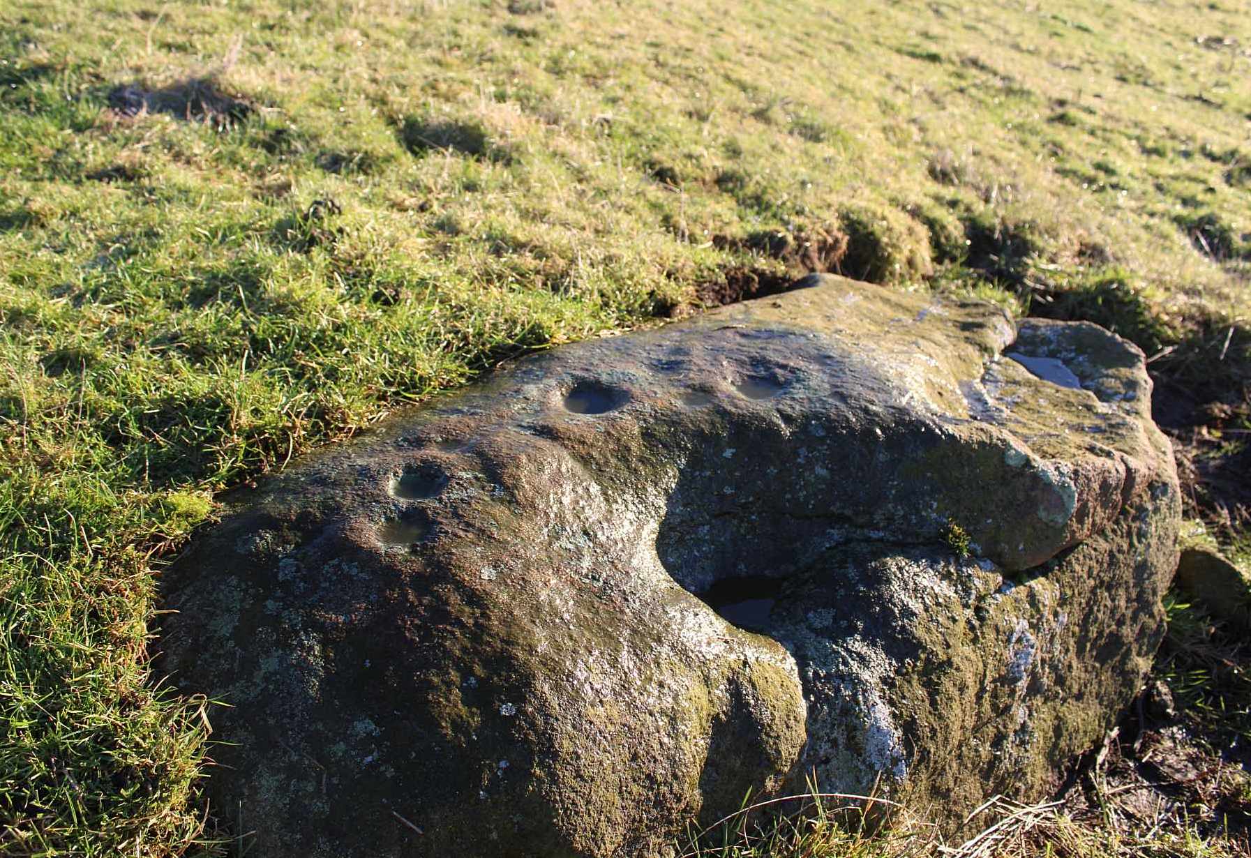
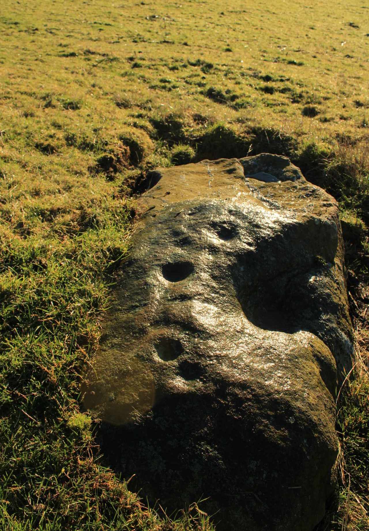
From near Skipton town centre, at the Cross Keys Inn along Otley Road, go up Short Bank Road all the way to the very top and then into the trees onto the Dales High Way footpath. Walk up for literally ¼-mile (0.4km) and where the path bends and heads ENE, notice here a footpath that takes you over the wall. Once on the other side, the path splits with one heading SE and the other roughly alongside the walling to the SW, which is where you need to go. About 200 yard on, go through the gate into the field and then another 375 yards on you’re into another field (copse of trees in front of you). Just as you’ve gone into this field, walk immediately left, uphill, by the walling for about 100 yards, over the marshy dip, then head into the field where, about 75 yards in, you’ll see some rocks scattered about…
Archaeology & History
Cleland Stone, looking S
In an area that’s had some considerable quarrying done to it, we’re lucky to find that this carving still exists. It was rediscovered by Thomas Cleland (hence its name!) in the summer of 2024. It consists of four distinct cups, with a possible fifth (and maybe more?) on its smooth elongated surface. The cups, as we can see, are quite deep and unmistakable. An incomplete ring seems to be around at least one of the cups; and there seems to be a carved straight line running between another two of them. A simple but distinct design and in a lovely setting gazing cross the Airedale valley from here.
There are very few other carvings in this neck o’ the woods (the Great Laithe Wood carving aint too far away), but the fact that this has been found would suggest that others are probably hiding away in the undergrowth. Check out the Iron Age Horse Close Hill enclosure while you’re up here too.
Acknowledgements: A huge thanks to Thomas Cleland, not only for finding the carving, but also for allowing use of his photos in this site profile.
Cup-and-Ring Stone: OS Grid Reference – NT 200 522
Also Known as:
La Mancha
Archaeology & History
Simpson’s 1867 drawing
This is what I’ve come to term dyslexic cup-and-rings, due simply to the fact that it’s a cup-and-ring stone carving, but the cup in the centre hasn’t been carved out or pecked away. They’re rare – but for some odd reason, a small cluster of them occurs in this part of lowland Scotland. The Drumelzier carving 13 miles SSW is one; the Carnwath carving 14 miles west is another; 14 miles to the south, the multiple-ringed carving in the Woodend cairn had no defined pivotal cup; and in Childe & Taylor’s (1938) short piece on the Hawthornden petroglyphs near Roslyn (less than 10 miles northeast), they noted—like Simpson & Thawley (1972) years later—the peculiarity of “the complete absence of cups”, akin to Lamancha’s carved rings. (although we should be cautious about the archiac nature of the Hawthornden carvings)
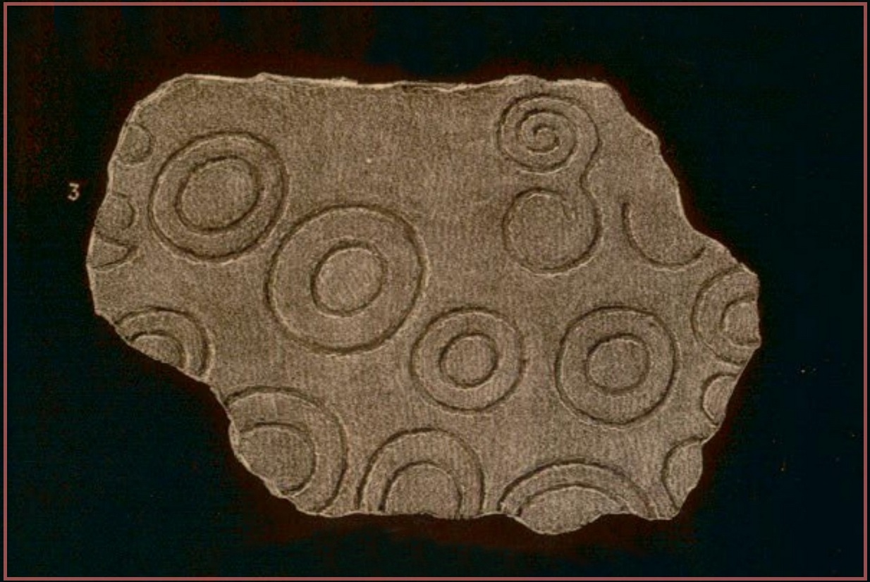
The carving here was first mentioned by one of the great petroglyphic pioneers James Simpson (1866; 1867):
“A broken slab, about two feet square, covered with very rude double rings and a spiral circle, was found by Mr Mackintosh, at La Mancha, in Peeblesshire, in digging in a bank of gravel. There were some other large stones near it; none of them marked. Possibly this stone, therefore, is sepulchral in its character.”
Lamancha carving (G. & A. Ritchie, 1972 )
Eoin MacWhite (1946) was somewhat sceptical of Simpson’s “sepulchral” association, simply due to there being no account of a burial here. But in Simpson & Thawley’s (1972) survey of passage grave art, they thought the Lamancha carving was from “a possible cist slab.” We might never know for sure one way or the other.
The carving ended up living in Edinburgh’s National Museum where it should, hopefully, still be on display. As a result of this, it received the attention of the Royal Commission doods who gave a good description of the design in their Peeblesshire Inventory (1967). They state that it
“is irregular in shape and has maximum dimensions of 2ft 6in by 1ft 10in; it averages 4in in thickness. The markings, which have all been formed by the pecking technique, occur mainly on one face, the most common symbol being single or double rings. There are four complete double-ring symbols, in which the outer rings measure from 5in to 7in in diameter, and the inner rings from 2in to 4in. Round the margin of the face there are the broken arcs of five more double-ring symbols and of five single rings and one small V -shaped figure. As well as the ring markings there is a double-spiral, each lobe of which measures about 4in in diameter. In one lobe the spiral has two and a half turns and in the other only one turn. In addition, in a space which is otherwise free of markings, there is an area, about 4in square, heavily pitted with punch-marks measuring one-eighth of an inch across and one-sixteenth of an inch in depth. A remarkable feature of the stone is that three incomplete single ring symbols have been made on one edge. They have been formed by the same technique and measure 3in across; as in all the other symbols, the grooves themselves measure about half an inch in width and about one-eighth of an inch in depth.”
McWhite, Eoin, 1946 “A New View on Irish Bronze Age Rock-Scriblings”, in Journal Royal Society Antiquaries, Ireland, vol. 76, 1946.
Morris, Ronald W.B., “The Cup-and-Ring Marks and Similar Sculptures of South-West Scotland,” in Transactions of the Ancient Monuments Society, volume 14, 1967.
Morris, Ronald W.B., “The Cup-and-Ring and Similar Early Sculptures of Scotland; Part 2 – The Rest of Scotland except Kintyre,” in Transactions of the Ancient Monuments Society, volume 16, 1969.
Morris, Ronald W.B., The Prehistoric Rock Art of Southern Scotland, BAR: Oxford 1981.
Ritchie, Graham & Anna, Edinburgh and South-East Scotland, Heinnemann: London 1972.
Royal Commission on the Ancient & Historical Monuments, Scotland, Peeblesshire – volume 1, Aberdeen University Press 1967.
Simpson, D.D.A. & Thawley, J.E., “Single Grave Art in Britain,” in Scottish Archaeological Forum, no.4, 1972.
Simpson, J.Y., “On Ancient Sculpturings of Cups and Concentric Rings,” in Proceedings of the Society of Antiquaries, Scotland, volume 6, 1866.
Simpson, James, Archaic Sculpturings of Cups, Circles, etc., Upon Stones and Rocks in Scotland, England and other Countries, Edmonston & Douglas: Edinburgh 1867.