Cruckles Well, Manningham, Bradford, West Yorkshire

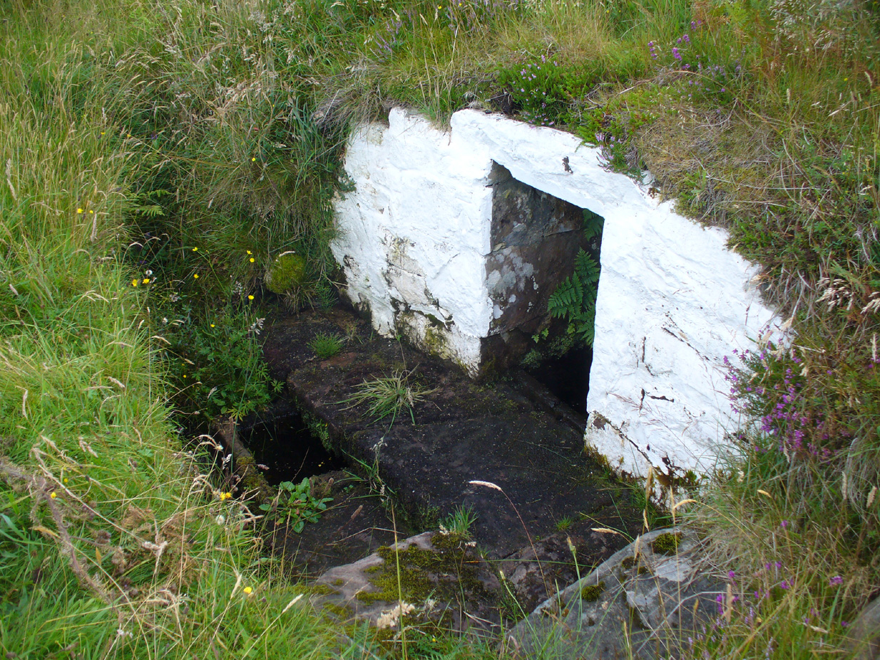
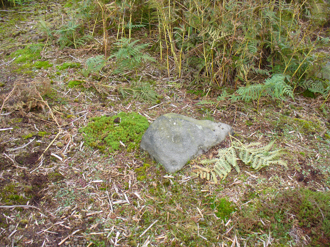
Sacred Well (lost):  OS Grid Reference – SE 160 339

Archaeology & History

Which one is the Cruckleswell?

In an essay by great regional historian Harry Speight (1912) on the ancient tracks of Bradford and district, he mentions this “Cruckleswell” which was first described in 1602.  Mentioned again in 1612 land deeds and several times thereafter, the site has long gone (been built over), but may have been a place where local people ascribed there being water spirits, or naiads.

Although the local historian W.E. Preston (1932) described the place as being in fields between Manningham Stoop (an old boundary stone, now lost) and Hallfield Cross (perhaps an old stone cross site, also lost), a more detailed article appeared a few years later by Wilfrid Robertshaw (1935), telling of its approximate location.  He wrote:

“The interesting field-name of Cruckleswell occurs in 1664.  Cruckleswell was situated between Manningham Stoope and Hallfield Cross.  The latter name is here applied to some closes of land near the Bradford-Manningham boundary and not to a monument; but from this qualifying statement must not be inferred the opinion that a stone or wooden cross of the name never existed.  From Manningham Stoope, whose location I have not traced, a lane led to Fair Gapp, which was just within the town of Bradford; but in 1686 there was a close called the Stoope, which adjoined Manningham Lower Lane on the left-hand side from Bradford to Manningham.  The occupiers of Cruckleswells were ordered by the jurors of the Bradford Manor Court to take in the water which ran by their premises.  The occurrence of a water-course thereabouts, together with the name, Cruckleswell, suggests that here, as in the Panewell Feilde, was a holy well of a kind.  Perhaps the derivation of the name may be found in the Yorkshire dialect word ‘crukle,’ meaning to make crooked, or to bend or twist.  In a sense, therefore, Cruckleswell was another pin well, into which bent of ‘cruckled’ pins were cast.  Cruckleswells, or Crookewells, as the three closes of land were called in a deed of 1658, were then granted by Tempest Brighouse, of Bilbie in the county of Nottingham, to James Mitchell of Bradford, yeoman.  But…I have found a deed of sale by Christopher Pighells of Bradford, yeoman, to John Nicholls of Horton, clerk, of the close of land called Cruckleswell… Nicholls purchased Cruckleswell in 1612, the year before Saxton produced his plan, on which the small field is shown adjoining others belonging to Pighells.  Thus the plan fixes the location of Cruckleswell; it adjoined the east side of the highway leading from Bradford to Frizinghall and was just within the Manningham township.”

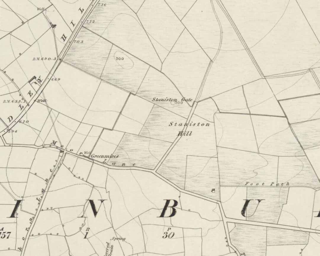
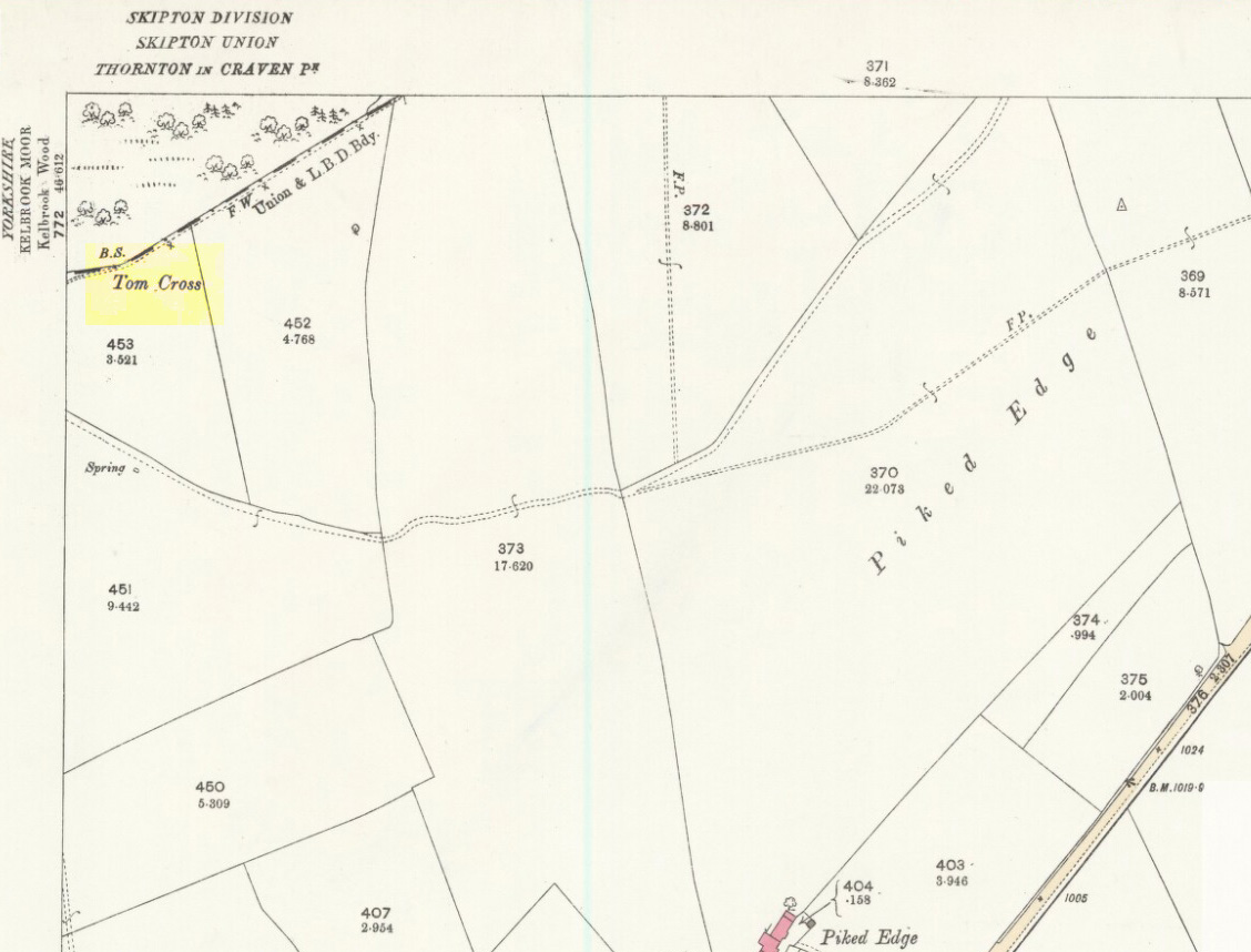
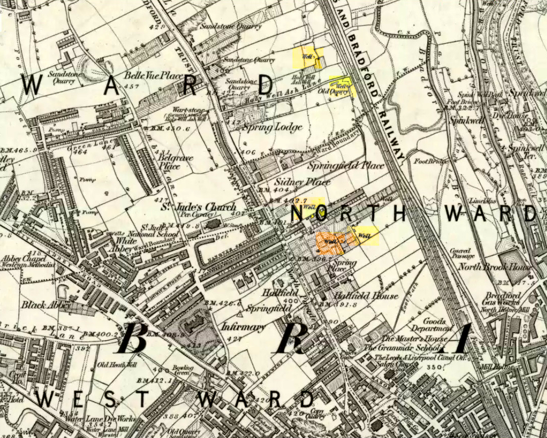
This would put it close to the Holy Well Ash well and its long-lost standing stone.  The 1852 OS-map of this area shows an unnamed well between the Holy Well Ash and the boundary line, as highlighted above; but another unnamed well is to the north of the holy well.  If we cross over the boundary line south and out of Manningham, three other wells existed less than 200 yards away.  Anyone of these may have been the Cruckleswell.

Mr Robertson’s idea on the word ‘cruckle’ is echoed in A.H. Smith’s (1961) place-name analysis of the site, where he relates how the word is “possibly connected with the obsolete crookle, ‘to crook, bed.'”  This is shown to be the case in Thomas Wright’s (1898) gigantic tome. And as “cruckling” pins was a common animistic practice in earlier centuries, this derivation of it—as being a well where offerings were given to the spirit of the waters—is not unlikely.

References:

  1. Preston, W.E., ‘Some Local Holy Wells,’ in Bradford Antiquary, June 1932.
  2. Robertshaw, Wilfrid (ed.), West Yorkshire Deeds (2 volumes), Bradford Historical & Antiquarian Society 1936.
  3. Shepherd, Val, Historic Wells of Bradford, Heart of Albion: Wymeswold 1995.
  4. Smith, A.H., The Place-Names of the West Riding of Yorkshire – volume 3, Cambridge University Press 1961.
  5. Speight, Harry, ‘Ancient Streets and Lanes of Bradford as Portrayed in the Manor Court Rolls,’ in Bradford Antiquary, New Series 3, 1912.
  6. Wright, Thomas, English Dialect Dictionary – volume 1, Henry Frowde: Oxford 1898.

© Paul Bennett, The Northern Antiquarian 


Queen’s Cairn, Farr, Strathnaver, Sutherland

Chambered Cairn:  OS Grid Reference – NC 7247 5687

Also Known as:

  1. Canmore ID 6212
  2. Skelpick

Getting Here

The great Queen's Cairn
The great Queen’s Cairn

From Bettyhill village, take the road east towards Tongue and Durness.  A half-mile out of the village, at the bottom of the hill, just before you cross the small metal bridge across the River Naver, a very minor road, left, takes you to Skelpick. Go down here and follow the directions to reach the giant long cairn of Skelpick Long.  Once there, walk east up the moorland hill (there are no footpaths) for about 150 yards.  Once on top of the rise, the moorland levels out a little and there, before you, amidst the small overgrown undulations of many old cairns, a giant one rises up to greet you about 100 yards away.  Y’ can’t really miss it!

Archaeology & History

Neolithic in nature, this giant circular cairn, standing on the ridge above the hugely impressive chambered long cairn of Long Skelpick, isn’t quite as grandiose as its neighbour below, but it’s still an impressive feature in this beautiful moorland landscape.  Comprised of tens of thousands of small stones raised to a height of 10 feet above the moorland peat, several ‘pits’ have been dug into the top of this undoubted tomb of regal nature; but whether it was originally the burial-place of a single person, to which were later added members of the same family, is simply unknown.

queens-cairn35
Moss-covered capstone
Depression atop of the cairn
Depression atop of cairn

On the top of the cairn, at least one of the so-called ‘pits’ that drop into the centre is covered by a large heavy tombstone with a small upright monolith at its side.  Although the late great Miss Henshall (2005) thought no ‘chamber’ was here, it is quite possible that a chamber might be found beneath this large moss-covered flat rock (see photo).  When we visited here, it looked as if there was a hollow beneath it, but only an excavation would tell us for sure.

Mass of cairns on 1878 map
Mass of sites on 1878 map

Highlighted on the earliest Ordnance Survey map, it was shown to be just one cairn amidst the mass of other smaller surrounding tombs—most of which were probably built for people from the same tribal group.  None of these small cairns have been excavated, but they were probably built after the construction of the major Queen’s Cairn.

The Royal Commission lads visited the site in 1909, but said very little of the place (probably over-awed by Long Skelpick, Coillie na Borgie and other nearby giants!), merely that this large circular cairn has

“a diameter of about 54′.  It is about 8′ high, and though the stones have been pulled about here and there on the top, it does not appear to have been excavated.”

Queen's Cairn, looking north
Queen’s Cairn, looking N

And so it remains to this day—although the cairn is slightly larger than the dimensions given by the Commission boys.  Beneath the encroaching heather, the cairn is closer to 67 feet (10.23m) across, with a circumference of 210 feet (64.25m).

Line of ancient walling nearby
Line of ancient wall nearby

The monument sits on a plateau immediately above the giant Long Skelpick cairn—although neither can be seen from each other.  But if you walk only a short distance from the Queen’s Cairn towards the long cairn below, a very notable and extensive line of ancient walling runs along the edge of the geological ridge separating the two tombs, as if deliberately keeping them apart.  Other lines of ancient walling run closer to the cairn, seeming to indicate that a settlement of some form was also apparent on this ridge, in close connection with the group of smaller burial cairns.

It’s a gorgeous arena with many prehistoric sites and puzzles to behold, and plenty of unrecorded ones nestling quietly in the heather.  It’s bloody superb to be honest!

References:

  1. Gourlay, Robert, Sutherland: An Archaeological Guide, Birlinn: Edinburgh 1996.
  2. Henshall, Audrey S. & Ritchie, J.N.G., The Chambered Cairns of Sutherland, Edinburgh University Press 2005.
  3. Royal Commission Ancient & Historical Monuments, Scotland, Inventory of Monuments and Constructions in the County of Sutherland, HMSO: Edinburgh 1911.
  4. Stuart, John, “Report to the Committe of the Society of Antiquaries of Scotland, Appointed to Arrange for the Application of a Fund left by the Late Mr A. Henry Rhind, for Excavating Early Remains,” in Proceedings of the Society of Antiquaries, Scotland, volume 7, 1868.

Acknowledgements:  Big thanks to the awesome Aisha Domleo & her frobbling Lara for our meandering day out to this olde place… Gorgeous! x

© Paul Bennett, The Northern Antiquarian 

Staniston Hill, Stainburn, North Yorkshire

Standing Stone (lost):  OS Grid Reference – SE 2522 5010

Archaeology & History

Staniston Hill on 1851 map

This long-lost standing stone gave its name to the small hill between the geological giants of Little Almscliffe and Almscliffe Crags, ‘Staniston Hill.’  Described as early as the 13th century in the Cartulary of Fountains Abbey as ‘Standandestan’, its precise whereabouts is unknown—but it’s damn close to the grid-reference cited here.  As the early OS-map shows, a small rounded hill occurs a short distance northwest of the small copse of trees now growing.  The monolith may have been felled by some grumpy christian, or it could be standing in some nearby walling.  Local antiquarians, dowsers or archaeologists may or may not find a search for it worthwhile…

Its position between the two Almscliffe Crags makes it very close to marking the midway point of a natural solstice marker: the Winter sunrise from Little Almscliffe and summer sunset from the greater Almscliffe.

References:

  1. Bennett, Paul, The Old Stones of Elmet, Capall Bann: Milverton 2001.
  2. Smith, A.H., The Place-Names of the West Riding of Yorkshire – volume 5, Cambridge University Press 1961.

© Paul Bennett, The Northern Antiquarian


Lighthouse Well, Dunnet Head, Caithness

Healing Well:  OS Grid Reference – ND 20422 75807

Getting Here

Lighthouse Well, Dunnet Head
Lighthouse Well, Dunnet

Take the B855 road northwards out of Dunnet village, through Brough and, nearly four miles on, you’ll see the waters of the Long Loch right by the roadside.  Roughly 300 yards along the side of the loch, keep your eyes peeled to left-hand side of the road, where you’ll see a white stone surround just below the roadside just a couple of yards away.  Right by its its side is a small stone with a plaque highlighting its position.  You can’t really miss it.

Archaeology & History

Stone & plaque by its side

Marked on the earliest OS-map of the region in 1875 (simply as “Well”), this is the most northerly example of a healing well in mainland Scotland, being a good mile further north than John o’ Groats!  Consisting of a standard stone surround, the well has two stone troughs: one inside the surround, and another outside, where the water runs, before being directed back to Earth.

Secondary stone trough
Second stone trough

Although the waters here have long since quenched the thirst of crazy travellers, the well was the main water supply for the men who lived and manned the famous Dunnet Head lighthouse in earlier years, who would carry the water from here more than half-a-mile up to their remote abode, overlooking the great cliffs and out towards megalithic Orkney.  Its healing properties have, sadly, long since been forgotten.  When we visited the site, the waters did not look to be in a healthy state to drink.

© Paul Bennett, The Northern Antiquarian


Tom Cross, Colne, Lancashire

Cross:  OS Grid Reference – SD 92102 43175

Also Known as:

  1. Copy House Cross

Getting Here

Tom Cross on 1892 map

Follow the same directions as if you’re visiting the Dissenter’s Well.  The cross stands right next to it!

Archaeology & History

This is one of two old stone crosses with the same name within a mile of each other (the other could be found in the walling along Warley Wise Lane).  Included in Taylor’s (1906) stunning magnum opus on the wells and crosses of Lancashire, the site was mentioned in a boundary dispute in the year 1592.  He told how a local man called Mr Carr said,

“John Parkinson, ‘of the age of ffour score and thirtiene year or thereabouts’ stated that Tom Cross and the Graystone were by credible report the boundaries, as well of Lancashire and Yorkshire, as of the manors of Colne and Cowling.”

Years later when Clifford Byrne (1974) surveyed the crosses of East Lancashire, he gave us more details about the site, saying:

Photo by Phil Waterworth
Tom Cross, looking N

“Tom Cross is built into the wall hard by Copy House Farm… At the foot of the Copy House Cross is a well, carved out of a solid block of stone.  The water apparently trickles into the well from a spring at the back of the wall , and the overflow spills into the field.  The top section of the cross is missing, probably it was vandalized at the time of the Reformation or some time afterwards.  It appears that the well was used and probably laid down by the Congregational Church dissenters from the late 17th century.  At that time, a law was passed, soon to be repealed, which decreed that every man should attend his Parish Church.  This meant that those who wished freedom to practise religion in their own form had to firstly attend the Parish Church and then hold a meeting privately afterwards.  At that time, and under those circumstances, it was obviously sensible to meet far away from the Parish Church, and apparently Tom Cross was chosen to meet this need.  The children of the Dissenters would be privately baptised in this well at the foot of the monolith into which, a cross was deeply incised.

Tom Cross is mentioned in a lawsuit in the year 1592 and a map exists dated slightly earlier which shows another cross in the area on Greystone Moor near Blacko…”

Tom Cross stone
Tom Cross stone

Byrne suggested that the name ‘Tom Cross’ relates to a boundary cross, but this is not substantiated in local dialect or place-name surveys (who say nothing!).  Instead, Joseph Wright (1905) gives us the possibility of Tom being simply, “a kind of rock”; although a variety of other associations relate it children’s games, customs and goblins. The word may derive from the Gaelic ‘tom’, relating to a mound, or clump, or knoll in the landscape (Watson 1926).  I’d go for one of these misself.  Makes sense.

References:

  1. Byrne, Clifford H., “A Survey of the Ancient Wayside Crosses in North East Lancashire,” unpublished manuscript, 1974.
  2. Taylor, Henry, The Ancient Crosses and Holy Wells of Lancashire, Sherratt & Hughes: Manchester 1906.
  3. Watson, W.J., The Celtic Placenames of Scotland, Edinburgh 1926.
  4. Wright, Joseph (ed.), English Dialect Dictionary – volume 6, Henry Frowde: Oxford 1905.

Acknowledegments:  Big thanks to Chris Swales for guiding me to the site; and to the old Teddy Man, Danny Tiernan.

© Paul Bennett, The Northern Antiquarian 


Easter Nether Urquhart Circle, Gateside, Fife

Stone Circle (destroyed):  OS Grid Reference – NO 18873 08865

Also known as:

  1. Canmore ID 27809

Getting Here

1856 map showing Easter Nether Urquhart remains

Turn off the A91 road at Gateside and go down Station Road, crossing the old railway line at the bottom.  From here, cross the fields to your left and the site of the circle will be found in the field to the north east of Easter Nether Urquhart Farm.

Archaeology & History

Marked on the 1856 6″ Ordnance Survey map as a “standing stone,” earlier references record this as being the survivor of a stone circle.  Not listed in Aubrey Burl’s (2000) magnum opus, this circle was on the edge of the site of a major battle between the Romans and the native defenders, and large amounts of human remains have been found in the vicinity.  Referring to an adjacent cairn, Lieutenant-Colonel Miller wrote in 1829:

“A very fine Druid’s Temple stood on the south side of it, consisting of seven very large stones. All these were blasted with powder and removed, except half the one of them, which still marks the spot.”

Of the same cairn, the Reverend Andrew Small wrote in 1823:

“This cairn stood a little north of an ancient Druids’ temple, only one stone now remaining, out of ten of which it formerly consisted.”

The Ordnance Survey Name Book for 1853-55 imparts the following:

“This standing Stone is about 13 chains on the South side of the River Eden opposite Edensbank but whether it is the remains of a druid’s temple or set up to mark something relative to the battle contested between the Romans and Caledonians according to Messrs. Miller & Small, it is difficult to determine. It stands about 4 feet 10 inches high and its sides are about 2 feet broad…many of the inhabitants consider it to have been a druid’s temple…”

A close-up of the site
Position of the circle, evident in crop-growth

J.S. Baird of Nether Urquhart informed an Ordnance Survey officer in 1956 that the remaining stone was broken up and removed around 1952, and measured 5 feet high with a girth of 9 feet at the base. Near the top of the stone, on the south-side were two slight cracks weathered to suggest a simple incised cross.

On the day of my November field-visit the winter barley was sprouting and it was interesting to see how much better it was growing at the place where the remaining stone had stood.

A standing stone at Wester Nether Urquhart, rediscovered by Maggie Overett in July 2020, can be seen a half-mile southwest.

References:

  1. Burl, Aubrey, The Stone Circles of Britain, Ireland and Brittany, Yale University Press 2000.
  2. Miller, Lieutenant-Colonel, “An Inquiry respecting the site of the battle of Mons Grampius (Read 27th April 1829 and 25th January 1830),” in Proceedings of the Society of Antiquaries of Scotland, Volume IV, 1857.
  3. Small, Reverend Andrew, Interesting Roman Antiquities Recently Discovered in Fife Ascertaining the site of the Great Battle fought betwixt Agricola and Galgacus, John Anderson & Co: Edinburgh 1823.

© Paul T. Hornby 2016 – The Northern Antiquarian 


Dunruchan Hill, Muthill, Perthshire

Standing Stone:  OS Grid Reference – NN 8022 1645 

Getting Here

Lisa standing with the old stone
Lisa with the old stone

Take the directions to the hugely impressive Dunruchan A standing stone.  Walk directly south, over the gate and follow the fence straight down the fields, crossing the burn at the very bottom. Walk over the boggy grassland and start veering uphill, southeast.  You’ll notice the land goes up in geological ‘steps’ and, a few hundred yards up, a small standing stone pokes up on the near skyline ahead of you.  Head straight for it!

Archaeology & History

This small standing stone was first noted after a quick visit to the major Dunruchan megalithic complex in the summer of 2016.  Photographer James Elkington was taking images of the landscape and the standing stones when he noticed a stone on the horizon a half-mile away.  As we were in a rush, he took a couple of photos from different angles on the way back to the car—both of which looked promising.  And so, several months later, we revisited the site again.  Lisa, Paul and Mr Fukner and I meandered up the geological steps of the hillside until we reached the site in question.

Looking northwest
Looking northwest
Looking northeast
Looking northeast

Standing just over four-feet tall, this solitary stone overlooks the megalithic Dunruchan complex a half-mile or so to the north and northwest.  Like the Dunruchan C monolith, this smaller upright is conglomerate stone.  Paul Hornby noted what may be a single cup-marked stone roughly 100 yards east along the same ridge. (Please note that the grid-ref may be slightly out by perhaps 50 yards or so at the most. If anyone visits and can rectify my ineptitude on this matter, please let me  know.)

© Paul Bennett, The Northern Antiquarian 


Grey Stone, Newsholme Dean, Oakworth, West Yorkshire

Cup-Marked Stone:  OS Grid Reference – SE 00621 40841

Also Known as:

  1. Carving no.2 (Boughey & Vickerman)

Getting Here

Grey Stone, Newsholme Dean

Take the same directions as if you’re visiting the Cob Stone Field carving; but instead of going into the field on your right, walk down the track about 100 yards towards the large barn below.  As you walk down keep your eyes peeled to the field on your left and, right up against the wall of the barn, you’ll see a large boulder resting quietly. That’s what yer after!

Archaeology & History

This large faded cup-marked rock whose western side has been split off in recent years, has a scatter of “up to 21 small shallow worn cups” on its upper surface.  They can be difficult to see in some light, but they’re definitely there (as Ray Spencer’s photos clearly show), fading slowly into Nature’s winds and storms.  A couple of ‘lines’ running down the edge of the stone are  due to modern farm-workings.

Close-up of the cups
Sketch of the design

Several other rocks in this and adjacent fields have what may be faded remains of other cup-markings, but without guidance from a geologist or a stone-mason, we can’t know for sure whether they’re authentic or not.  It’s likely that there are other authentic carvings hiding in this area—they just need sniffing out!

References:

  1. Boughey, Keith & Vickerman, E.A., Prehistoric Rock Art of the West Riding, West Yorkshire Archaeology Service 2003.

Acknowledgements:  Huge thanks to Ray Spencer for us of his photos in this site profile. Thanks Ray.

© Paul Bennett, The Northern Antiquarian 


Picketts Beck East, Askwith Moor, North Yorkshire

Cup-and-Ring Stone:  OS Grid Reference – SE 1708 5054 —  NEW FIND

Getting Here

Cup-and-ring stone in situ

From the Askwith Moor Road parking spot, head across the road and take the directions to the Woman Stone carving about 510 yards (467m) across the moors to the west.  From here, look straight down the slope and head towards the largest boulder at the bottom, 20-30 yards away.  About 10-20 yards to the right of this, zigzag about in the vegetation until you find the small stone amidst the bracken.  You’ll find it!

Archaeology & History

This small stone, whose natural contours and cracks have been utilised in the design of the petroglyph, may once have been part of a prehistoric tomb, perhaps rolled or thrown downhill from the nearby Askwith Moor Cairnfield.  I say this due to the size and portability of the stone, i.e., it’s small and barely earthfast, giving an increased likelihood that its present position was not its original one.  But we might never know…

Rough sketch of the design
Close-up of the carving

It’s almost archetypal in design, being a primary cup-and-ring, with what appears to be a faint inner ring etched marginally within the larger notable incomplete circle, just an inch beyond the inner central cup.  From this same cup runs a carved line, out to the near edge of the small stone.  Single cup-marks occur on the edges of the rock, as can be seen in the photos: three, possibly four of them.  One of the cups, where the stone narrows to a rounded point, may also have had a partial ring around it.  When we found this stone a few weeks ago, the day was grey and overcast and the light was poor, so our photos do not highlight the carving too well.

(Note: the OS grid-reference for this stone is an approximation: pretty damn close, but not close enough. If someone ventures here and can get the exact grid-ref, we’d be most grateful.)

© Paul Bennett, The Northern Antiquarian 


Wester Cairnfield (02), Askwith Moor, North Yorkshire

Cup-Marked Stone:  OS Grid Reference – SE 1698 5070

Getting Here

Faint cupmarks clearly visible

From the Askwith Moor Road parking spot, head west to the Askwith Moor cairnfield. Keep walking west, going downhill past the main cluster of rocks.  If you begin zigzagging amidst the heather hereby, you’ll eventually come across this relatively small stone which, even when the heather is deep, thankfully rises to the surface.  The Wester Cairnfield 1 carving is close by.

Archaeology & History

Although I presumed that Graeme Chappell and I found this petroglyph when we surveyed the area in the 1990s, I cannot find an early account of it in my files, so must presume that when James Elkington, James Turner and I came across it a few weeks ago, it was the first view of the stone in many a century… It’s another simple carving, only of interest to the mad rock art hunters out there.

...and from another angle
…and from another angle

When we first found it, it seemed to me (with the sunlight effects on the stone) that two cup-marks had been etched here; but as Mr Elkington pointed out, from the angle he was looking at the stone, there were another two.  He was right.  But it’s nothing special to look at, sadly, and is probably only of interest to the real hardcore petroglyph nutters amongst you. (please note that the grid-ref for this carving needs revising and may be 50 yards either side of the one given)

© Paul Bennett, The Northern Antiquarian