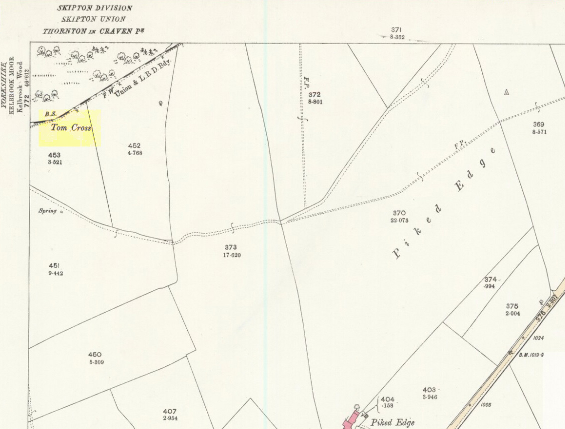
Follow the same directions as if you’re visiting the Dissenter’s Well. The cross stands right next to it!
Archaeology & History
This is one of two old stone crosses with the same name within a mile of each other (the other could be found in the walling along Warley Wise Lane). Included in Taylor’s (1906) stunning magnum opus on the wells and crosses of Lancashire, the site was mentioned in a boundary dispute in the year 1592. He told how a local man called Mr Carr said,
“John Parkinson, ‘of the age of ffour score and thirtiene year or thereabouts’ stated that Tom Cross and the Graystone were by credible report the boundaries, as well of Lancashire and Yorkshire, as of the manors of Colne and Cowling.”
Years later when Clifford Byrne (1974) surveyed the crosses of East Lancashire, he gave us more details about the site, saying:
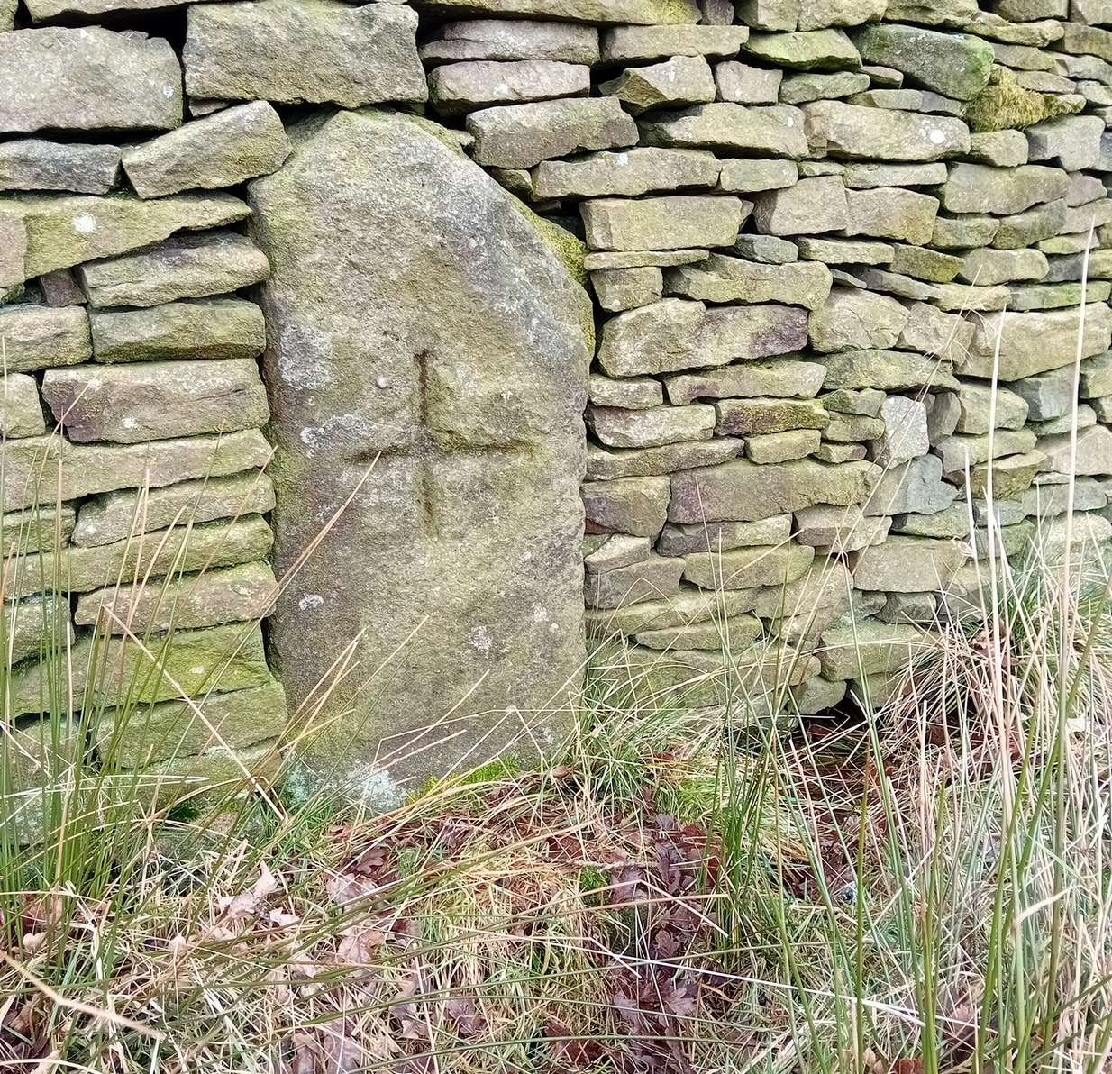
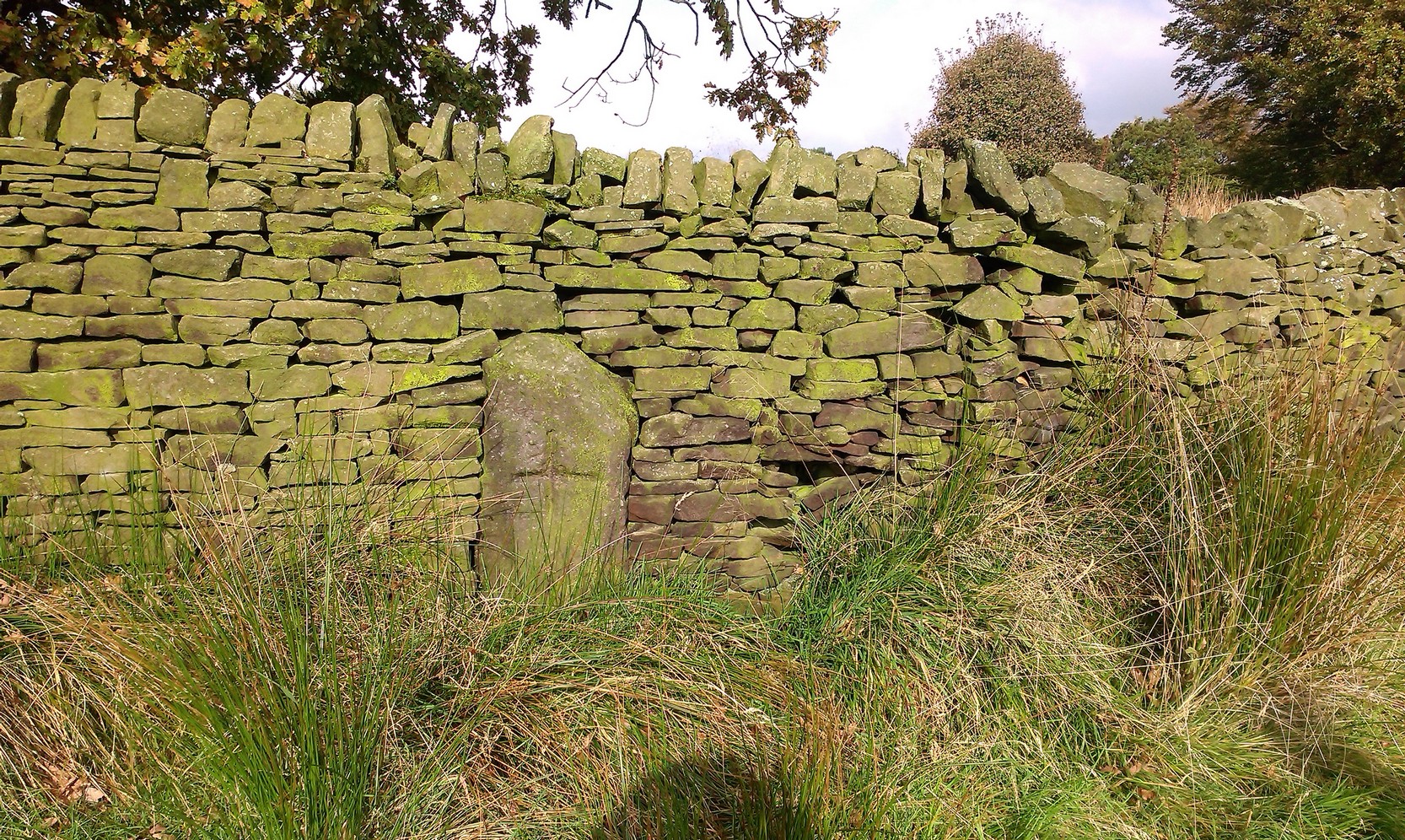
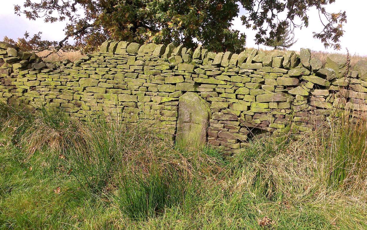
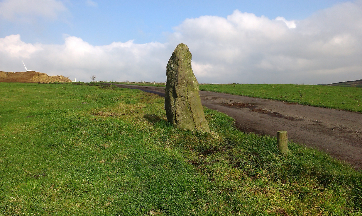
Photo by Phil WaterworthTom Cross, looking N
“Tom Cross is built into the wall hard by Copy House Farm… At the foot of the Copy House Cross is a well, carved out of a solid block of stone. The water apparently trickles into the well from a spring at the back of the wall , and the overflow spills into the field. The top section of the cross is missing, probably it was vandalized at the time of the Reformation or some time afterwards. It appears that the well was used and probably laid down by the Congregational Church dissenters from the late 17th century. At that time, a law was passed, soon to be repealed, which decreed that every man should attend his Parish Church. This meant that those who wished freedom to practise religion in their own form had to firstly attend the Parish Church and then hold a meeting privately afterwards. At that time, and under those circumstances, it was obviously sensible to meet far away from the Parish Church, and apparently Tom Cross was chosen to meet this need. The children of the Dissenters would be privately baptised in this well at the foot of the monolith into which, a cross was deeply incised.
Tom Cross is mentioned in a lawsuit in the year 1592 and a map exists dated slightly earlier which shows another cross in the area on Greystone Moor near Blacko…”
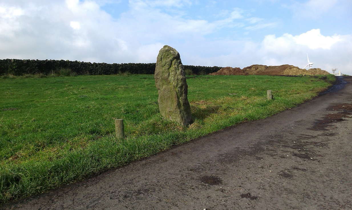
Tom Cross stone
Byrne suggested that the name ‘Tom Cross’ relates to a boundary cross, but this is not substantiated in local dialect or place-name surveys (who say nothing!). Instead, Joseph Wright (1905) gives us the possibility of Tom being simply, “a kind of rock”; although a variety of other associations relate it children’s games, customs and goblins. The word may derive from the Gaelic ‘tom’, relating to a mound, or clump, or knoll in the landscape (Watson 1926). I’d go for one of these misself. Makes sense.
References:
Byrne, Clifford H., “A Survey of the Ancient Wayside Crosses in North East Lancashire,” unpublished manuscript, 1974.
Taylor, Henry, The Ancient Crosses and Holy Wells of Lancashire, Sherratt & Hughes: Manchester 1906.
Watson, W.J., The Celtic Placenames of Scotland, Edinburgh 1926.
Wright, Joseph (ed.), English Dialect Dictionary – volume 6, Henry Frowde: Oxford 1905.
Acknowledegments: Big thanks to Chris Swales for guiding me to the site; and to the old Teddy Man, DannyTiernan.
From Colne or Laneshaw Bridge, head up the Skipton Old Road which heads up towards Bleara Moor (with its prehistoric cairns). Way before that though, about 100 yards before you reach the Black Lane Ends pub, turn left up the track to Jerusalem Farm. Go past it, through the gates and keep on the track until, another coupla hundred further uphill, you’ll see it on the skyline ahead of you…
Archaeology & History
There appears to be no previous reference to this standing stone, found high upon the lonely ridge beside the old track that runs between Laneshaw Bridge and Kelbrooke and Earby. Well eroded on all sides, it isn’t shown on the early or recent maps and has evaded the archaeological registers of the area (but this is Lancashire, where archaeology has been damn lazy on the county’s prehistoric relics until very recently). It may have been laid down for an age, only recently resurrected—we simply do not know. Standing nearly five-feet tall, on its top western face is what looks like a very faded cup-marking, but this may be a fortuitous Rorscharch. There are no marks or holes in the stone to indicate it has ever been used as a gatepost.
Looking far into the eastLooking northwest
I was guided here by the northern antiquarian and stonemason Chris Swales a few weeks ago and was quite taken aback by its position in the landscape—which is outstanding! Apart from being blocked to the west by the rise of the Great Edge, the views to the north through east and south and superb. On the far eastern skyline rises the legendary Hitching Stone, between which is the seemingly cairn-less Knarrs Hill.
Further north along the track we reach the old Dissenter’s Well and its moving companion, the Tom Cross (which has marked different parts of the Lancashire and Yorkshire boundary). Other than this, we know nothing more. An intriguing spot and well worth visiting!
Along the high moorland road between Laneshaw Bridge up towards Oakworth, on the Lancashire side of the moors a half-mile before reaching the Watersheddles reservoir, past the derelict pub until you reach the isolated Coombe Cross farmhouse on the tops. Across the road from here is a boggy footpath leading onto the moors. Walk on here for 100 yards, where the path bends left and another footpath veers up higher onto the moors. Walk up here for 20 yards and you’ll see the small monolith 10 yards away in the grassy heaths on your left.
Archaeology & History
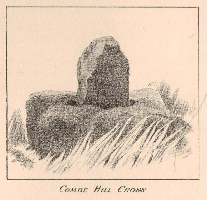
Taylor’s 1906 drawing
Found on the old route between the counties of Yorkshire and Lancashire, this little-known wayside cross has seen better days. Found in relative isolation from other monuments by the ancient trackway (Herder’s Cross is a mile WNW, and the curious Water Sheddles Cross a mile east), its history is quiet and it was ignored in the general surveys of such monuments by Rimmer (1875), Tyack (1900) and Vallance. (1920) Thankfully the giant survey of Henry Taylor (1906) did not forget it—although he seemed to know little of its story, merely telling us,
“The base-stone and part of the upright shaft of this cross stand about one hundred yards in a south-easterly direction from (Far Combe Hill Cross)… Two hundred yards south of the Combe Hill Cross occur the words, ‘Cross Bent.'”
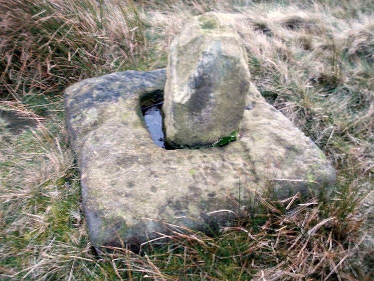
Coombe Hill Cross (photo by Ray Spencer)
The near-square stone base—about 3 feet by 3 feet—is commonly ascribed as medieval in origin and it’s thought that the remaining upright cross-stump—over 2 feet high—is probably not the original one. When fellow antiquarian Ray Spencer visited the site recently, he reported there to be “a faint inscription on the base saying COMBE HILL CROSS.”
The most detailed account of this monument was to be found in Clifford Byrne’s (1974) unpublished paper on the antiquities of the region, where he wrote:
“The pedestal of this cross with a piece of stone sitting in it which may or may not be part of the original monolith is situated on a wayside hillock… On passing the Herders Inn above Emmot, scrutiny of the left hand side of the road at the top of the next rise ahead opposite a white farmhouse will show what looks like a stumpy finger pointing to the sky. Close inspection will show that at the site sits the pedestal of a cross, apparently settled on two steps. Note that the pedestal and the supporting stones beneath have a remarkable resemblance to Carlton Cross which stands on Cross Green between Tom Cross Ainslack and Carleton village near Skipton. It may be that both monoliths were erected by the same hands. Whether the supporting blocks beneath the pedestal were for purposes of kneeling, or merely to stop the edifice sinking into the moor is…open to dispute. An ancient track passes the cross site where it splits into two: one going east towards Keighley and the other going south towards Haworth by Watersheddles Cross. A continuation of the track westwards travels along the foot of Boulsworth Hill past Iron Age burials,* along a fine set of pack horse setts, past standing stones, old lime kilns, and eventually leaving behind some remains of the Wycoller Vaccary stones near Antly Gate Farm. It tops the brow of a hill and drops down through Thursden by the Cold Well itself a a little green gate in the reservoir wall. Marquis of Colne suggested that the Combe Hill Cross dates from the time of King Stephen in the 12th century, but does not say on what he based his surmise…. If the origin of the stone is dated correctly, it has stood near Colne for over 800 years.”
References:
Byrne, Clifford, A Survey of the Ancient Wayside Crosses in North-East Lancashire, unpublished 1974.
Taylor, Henry, The Ancient Crosses and Holy Wells of Lancashire, Sherratt & Hughes: Manchester 1906.
* These Iron Age burials may be Bronze Age as we have found remains of several hut circles dating from that period in this area. PB.
Acknowledgements: Huge thanks to Ray Spencer for use of his photos and additional data for this site profile.
Follow the directions to reach the Herder’s Cross, not far away. Standing on the Herder’s Cross stone, look across the fields to the north (away from the farmhouse on the hill below) and you’ll see a nice-looking stream a coupla hundred yards ahead of you. Crossing this stream you see the large boulder, which you can see clearly if you’re stood on the Herder’s Cross. That’s where you’re heading!
Archaeology & History
A curious entry inasmuch as I’ve found no other references to the place. It’s an obvious cross-base, albeit very worn, cut onto the top of this large boulder, as you can see in the photo. What may be a singular cup-marking (if you’re a New-ager, or work for English Heritage that is!) is on the western side of the rock — but without additional markings on the rock, this has gotta be questionable.
Dodgy cup-marking on top!Shallow cross-base
The cut ‘square’ measures eight-inches both sides, but it seems that the cutting on the north-eastern sides of the base was never finished. The depth of the cross-base is also very shallow, only an inch deep. There seems to be a distinct possibility that this particular stone was initially chosen as a wayside cross marker, then for some reason perhaps moved to the position of the Herder’s Cross in the fields 420 yards (383m) to the south of here.
Clifford Byrne (1974) suggested that the pathway hereby was an ancient routeway that led towards the Emmot Holy Well, three-quarters of a half-mile down the hillside from here. Any further info or thoughts on this side would be most welcome.
References:
Byrne, Clifford, A Survey of the Wayside Crosses in North East Lancashire, unpublished manuscript, 1974.
From Laneshaw Bridge, near Colne, take the long country road that goes up above Wycoller to Stanbury and Haworth over the Yorkshire-Lancashire border. A couple of miles uphill, there’s a parking spot with views across the moors. Stop here. Cross the road and walk up for about 100 yards, going thru the rickety gate on the left, and up the field (past the small disused quarry) until you see the large rock looming ahead of you, perched on its own. That’s it!
Archaeology & History
Herders Cross stone
This is a really curious spot to me. A large singular boulder sat on the edge of an uninhabited moorland with no real history of heathenism, nor religious practices; yet someone at sometime in the not-too-distant past saw something here that made them cut a large square hollow into the top of this stone, in which they stuck an old cross. We came across this site a few weeks ago quite by accident, but realised that the deep hollow in the rock was an old cross base; so when I got home I checked Taylor’s (1906) magnum opus, expecting to find some info therein. But even Taylor seemed to know nothing of this place.
A week or two later, Paul Hornby pointed me in the direction of an unpublished essay by a local chap called Clifford Byrne (1974) who’d studied some of the early christian remains in the region and who wrote the following of what he named “Herders Cross”:
“This cross, or more properly its socket, is probably one of the least known in the area. It was shown to the writer by Mr Stanley Cookson of Trawden, who discovered the socket in passing, so to speak. On the road to Haworth from Laneshawbridge, opposite the site of Foster’s Leap rocks, on the east side of the road, is a really huge boulder on the moor top. In the south side is the cross socket, whilst on the north side of the rock can be made out a right-angled mark which implies that either the socket was being placed on that side in the first instance, or that two sockets were once envisaged…
“Old maps show the rock in situ with a “shaft” protruding from the top. Some yards west a shallow pony track bypasses the site, whilst some four or five hundred yards east a very well worn and ancient road, long unused, passes in the direction of Emmot Holy Well. The cross may thus have been a Wayside Cross showing the way to this Holy spring which is remembered as being propitious in the cure of rheumatism.”
Cross-base socket
This may be so; but I suspect earlier, heathen remains upon the moors here to explain the curious position of both this and another cross-base some 400 yards away. Some dubious cup-marks can be seen by the side of the stone hollow; and other dubious ones have been found on the moors above here. There is folklore of a lost stone circle on the hills above here, and a scattering of little-known faerie lore, indicating hidden sites and lost myths. These ingredients are more likely the reasons that Herders Cross was erected here, overlooking the countryside south and west, with the holy hill of Pendle rising in the centre of the distant landscape…
References:
Byrne, Clifford, A Survey of the Wayside Crosses in North East Lancashire, unpublished 1974.
Taylor, Henry, The Ancient Crosses and Holy Wells of Lancashire, Sherratt & Hughes: Manchester 1906.