This Stone is situated on Old Lane, Cowling, North Yorkshire. To get here coming from Crosshills, you come straight through the village and past the shops. About 250 yards after the shops you will come to a sharp left hand bend, and once you have gone round this corner you will see a sign pointing to Oakworth (Old Lane). You need to turn left here (up by the cemetery) and continue for about half a mile up that lane until you come to a sharp left-hand bend. Once you have gone round that left-hand bend you will see a driveway on the right, the stone is situated opposite, in the gateway. Hope you can find it and enjoy it like I do every time I pass it.
Archaeology & History
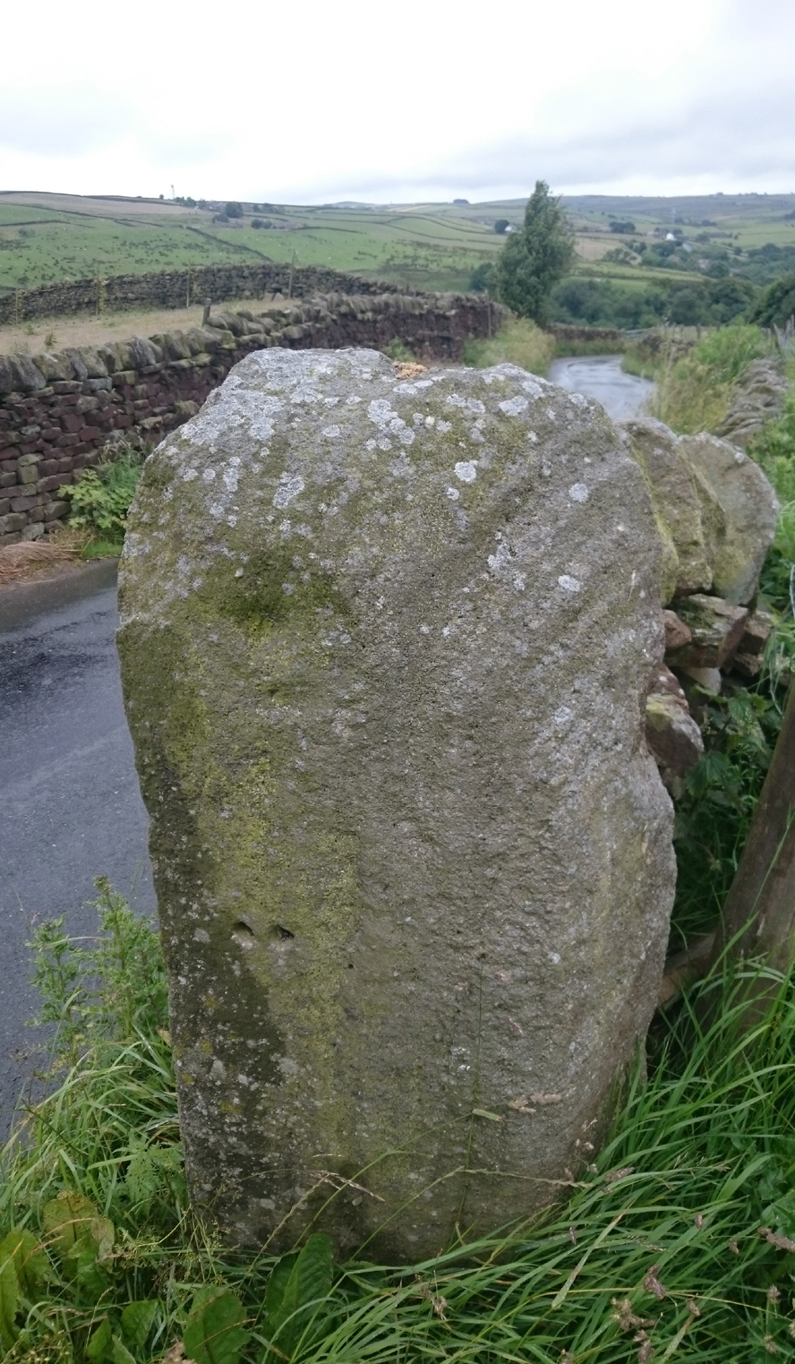
…and from another angle
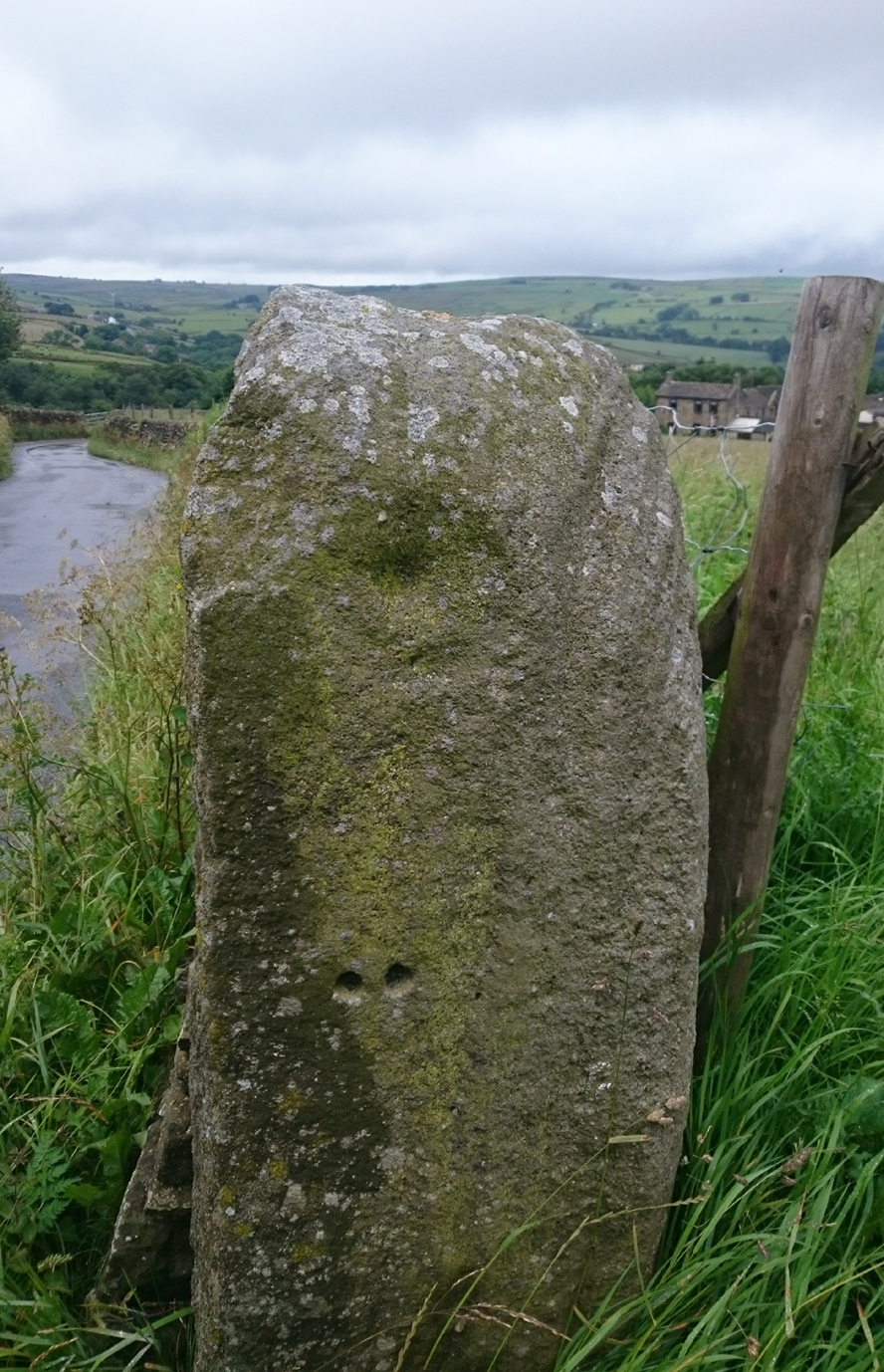
I’ve driven past this stone many times, almost every day and never previously noticed any markings. Then, one particular day, the weather was a bit miserable but the lighting was just right to illuminate this little gem. Was this lump of rock a standing stone, or have modern day folk took advantage and moved it here to be used as a gatepost? I don’t think we ever will know.
(Editor’s Note – When Chris first informed us of this carving, I wondered whether or not it had anything to do with a cup-and-ring found on a gatepost in the 1950s or ’60s by Stuart Feather or Sidney Jackson, but this was not the case. This petroglyph therefore, is yet another one that our users have discovered and it has to be classified as a new find. Keep up the good work sir! PB)
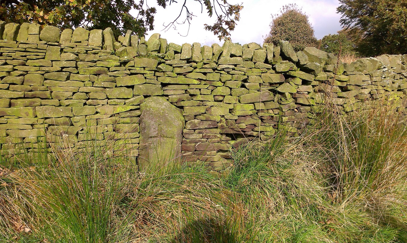
Follow the same directions as if you’re visiting the Dissenter’s Well. The cross stands right next to it!
Archaeology & History
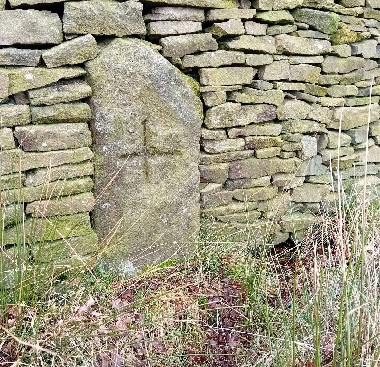
This is one of two old stone crosses with the same name within a mile of each other (the other could be found in the walling along Warley Wise Lane). Included in Taylor’s (1906) stunning magnum opus on the wells and crosses of Lancashire, the site was mentioned in a boundary dispute in the year 1592. He told how a local man called Mr Carr said,
“John Parkinson, ‘of the age of ffour score and thirtiene year or thereabouts’ stated that Tom Cross and the Graystone were by credible report the boundaries, as well of Lancashire and Yorkshire, as of the manors of Colne and Cowling.”
Years later when Clifford Byrne (1974) surveyed the crosses of East Lancashire, he gave us more details about the site, saying:
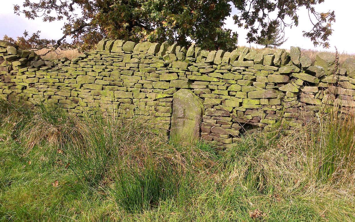
Photo by Phil WaterworthTom Cross, looking N
“Tom Cross is built into the wall hard by Copy House Farm… At the foot of the Copy House Cross is a well, carved out of a solid block of stone. The water apparently trickles into the well from a spring at the back of the wall , and the overflow spills into the field. The top section of the cross is missing, probably it was vandalized at the time of the Reformation or some time afterwards. It appears that the well was used and probably laid down by the Congregational Church dissenters from the late 17th century. At that time, a law was passed, soon to be repealed, which decreed that every man should attend his Parish Church. This meant that those who wished freedom to practise religion in their own form had to firstly attend the Parish Church and then hold a meeting privately afterwards. At that time, and under those circumstances, it was obviously sensible to meet far away from the Parish Church, and apparently Tom Cross was chosen to meet this need. The children of the Dissenters would be privately baptised in this well at the foot of the monolith into which, a cross was deeply incised.
Tom Cross is mentioned in a lawsuit in the year 1592 and a map exists dated slightly earlier which shows another cross in the area on Greystone Moor near Blacko…”
Tom Cross stone
Byrne suggested that the name ‘Tom Cross’ relates to a boundary cross, but this is not substantiated in local dialect or place-name surveys (who say nothing!). Instead, Joseph Wright (1905) gives us the possibility of Tom being simply, “a kind of rock”; although a variety of other associations relate it children’s games, customs and goblins. The word may derive from the Gaelic ‘tom’, relating to a mound, or clump, or knoll in the landscape (Watson 1926). I’d go for one of these misself. Makes sense.
References:
Byrne, Clifford H., “A Survey of the Ancient Wayside Crosses in North East Lancashire,” unpublished manuscript, 1974.
Taylor, Henry, The Ancient Crosses and Holy Wells of Lancashire, Sherratt & Hughes: Manchester 1906.
Watson, W.J., The Celtic Placenames of Scotland, Edinburgh 1926.
Wright, Joseph (ed.), English Dialect Dictionary – volume 6, Henry Frowde: Oxford 1905.
Acknowledegments: Big thanks to Chris Swales for guiding me to the site; and to the old Teddy Man, DannyTiernan.
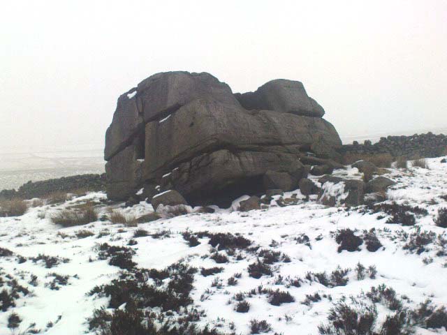
The easiest way to get here if you’re coming for the first time is via the A6068 Glusburn to Cowling road. On the south side of Cowling, take the small road Old Lane, uphill on the east side of the road (very easily missed – keep your eyes peeled!) and keep going up until the road just about levels out, where there’s a muddy parking spot on your left (the giant Wainman’s pinnacle is down the path from here). Cross over the road and head up towards the giant Hitching Stone. When you reach the first fence, cross over it and follow it into the boggy heathlands to your right (west-ish). Head into the tribbly grass and keep walking for 3-400 yards till you see the large rock growing out of the Earth.
Archaeology & History
Cup-markings near ground-levelLooking from above
Not far from the legendary Hitching Stone is this curiously-shaped boulder sitting peacefully and alone in its landscape. It is in fact a large cup-marked boulder, previously unrecorded until being described in The Old Stones of Elmet. On top of the stone it seems that there are no definite man-made cup-markings, but there are a number of seemingly natural ones (although some could have been etched thousands of years ago and have just eroded well); instead the real cup-markings are found curiously etched at the base of this large rock, just above ground-level.
Hitching Stone on horizon
As can be seen in the photos, on its lower south-facing edge there are around 20 well-defined cups that clearly stand out. No other cup-marked stones appear to be nearby (surely there’s a few more kicking about in the area…?).
An earlier assertion I made (2001) about the nearby Hitching Stone aligning with the winter solstice sunrise from here was recently put to bed following the morning observations of myself and Dave Hazell on December 21st, 2010, when — as can be seen in the photo here — the midwinter sun emerges from the land a few degrees of arc further southeast than expected. However, I aint checked what the alignment here would have been when the cup-markings were first etched here, around 5000 years ago perhaps… Would any of you archaeo-astronomers out there know about this?
The easiest way to get here is via Cowling – though you can approach the place via moorland roads from Sutton-in-Craven, Oakworth and Keighley, but Cowling’s the closest place (so we’ll take it from there). Turn east off the A6068 up Old Lane at the Ickornshaw side of town and go up the steep and winding road until you hit the moors. Just as the road levels out with walling on either side of the road, there’s some rough ground to your left. You can park here. You’ll blatantly see our Hitching Stone on the moorland a few hundred yards above you on the other side of the road. Walk up the usually boggy footpath straight to it!
Archaeology & History
For me, this is a superb place! Each time I come here the place becomes even more and more attractive — it’s like it’s calling me with greater strength with each visit. But that aside…
Supposedly the largest single boulder in Yorkshire, it possesses several legends, aligns with the sacred Pendle Hill in Lancashire, is an omphalos (centre of the universe spot) and has other good points too! My first visit here was near the end of the Great Drought of 1995. All of the streams and springs had dried up on the moors but, on the very top of this huge rock, measuring at least 8 feet by 4 feet across (and 3 feet deep) was a large pool of water, not unlike a bath, in which a couple of you could easily bathe (and do more besides, if the fancy takes you!). It was surreal! Water-boatmen and other insects were living in this curious pool on top of the rock. Yet all other water supplies for miles around had long since dried-up. It didn’t really seem to make sense.
Crystalline tunnel in the Hitching Stone
On the west-facing side of the boulder, about 8 feet up, is a curious deep recess known as the Druid’s or Priest’s Chair, into which initiates were sat (facing Pendle Hill, down which it seems the equinox sun “rolls”) and is believed, said Harry Speight, “to have some connection with Druidical worship, to which tradition assigns a place on these moors.” If you climb up and inside the Priest’s Chair section you’ll notice a curious “tunnel” that runs down through the boulder, about 12 feet long, emerging near the northern base of the rock and out onto the moor itself. This curious tunnel through the rock is due to the softer rock of a fossilised tree (Lepidodendron) crumbling away — and not, as Will Keighley (1858) believed, “the mould or matrix of a great fish.” When we visited the stone the other day in the snow, we noticed how the inner surface of this tunnel was shimmering throughout its length as if coated in a beautiful crystalline lattice (you can sort-of make this out in the image here, where the numerous bright spots on the photo are where the rock was lit up). Twas gorgeous!
The Hitching Stone, looking north
The boulder lies at the meeting of five boundaries, and was the starting point for horse-racing event until the end of the 19th century. A short distance away “are two smaller stones, the one on the east called ‘Kidstone’, the other ‘Navaxstone’, which stands at the terminus of the race-course.” (Keighley 1858) Lammas fairs were also held here, though were stopped in 1870.
The cup-marked Winter Hill Stone a few hundred yards to the northeast, which I previously thought aligned with this site around winter solstice, but which happens to be a few degrees of arc off-line, would have indicated a very early mythic relationship, but this thought may now have to be put to bed. I’ve not checked whether the winter solstice alignment shown in the photo below (with the Hitching Stone being shown on the near-horizon as the sun rose on winter solstice, 2010, from Winter Hill Stone) would have been closer in neolithic times or not. Summat to check out sometime in the future maybe…
This aside, there is little doubt that this was an important sacred site to our ancestors.
Folklore
Winter Solstice sunrise, 2010 (from Winter Hill Stone)
Legend has it that the Hitching Stone used to sit on Ilkley Moor. But it was outside the rocky house of a great witch who, fed up by the constant intrusion the boulder made to her life, tried all sorts of ways to move it, but without success. So one day, using magick, she stuck her wand (or broomstick) into the very rock itself and threw it several miles from one side of the valley to the other until it landed where it still sits, on Keighley Moor.
A variation on the same tale tells that she pushed it up the hill from the Aire valley bottom. The “hole” running through the stone is supposed to be where our old witch shoved her broomstick!