Follow the same directions as if you’re visiting the Dissenter’s Well. The cross stands right next to it!
Archaeology & History
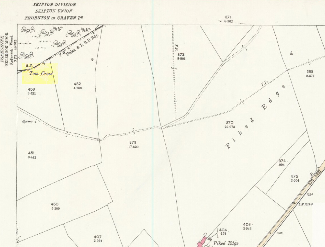
This is one of two old stone crosses with the same name within a mile of each other (the other could be found in the walling along Warley Wise Lane). Included in Taylor’s (1906) stunning magnum opus on the wells and crosses of Lancashire, the site was mentioned in a boundary dispute in the year 1592. He told how a local man called Mr Carr said,
“John Parkinson, ‘of the age of ffour score and thirtiene year or thereabouts’ stated that Tom Cross and the Graystone were by credible report the boundaries, as well of Lancashire and Yorkshire, as of the manors of Colne and Cowling.”
Years later when Clifford Byrne (1974) surveyed the crosses of East Lancashire, he gave us more details about the site, saying:
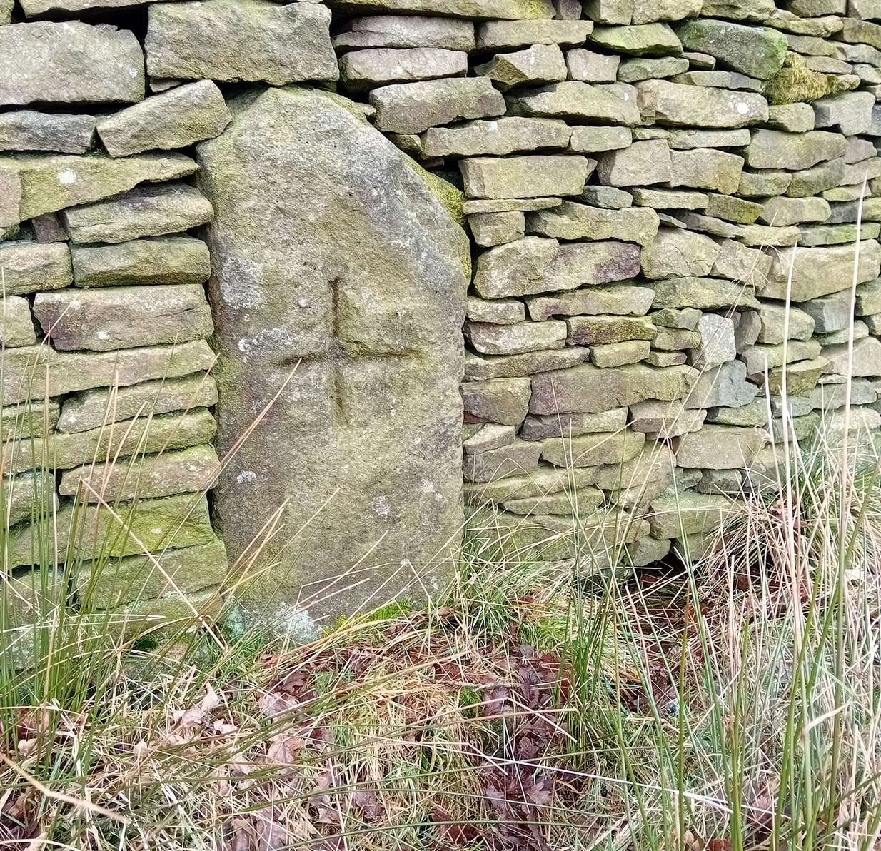
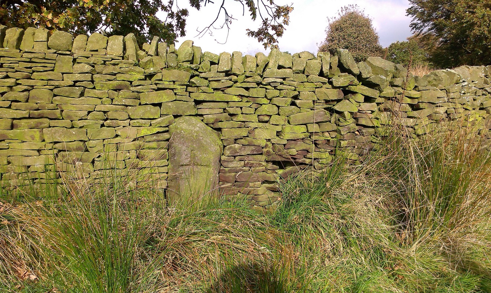
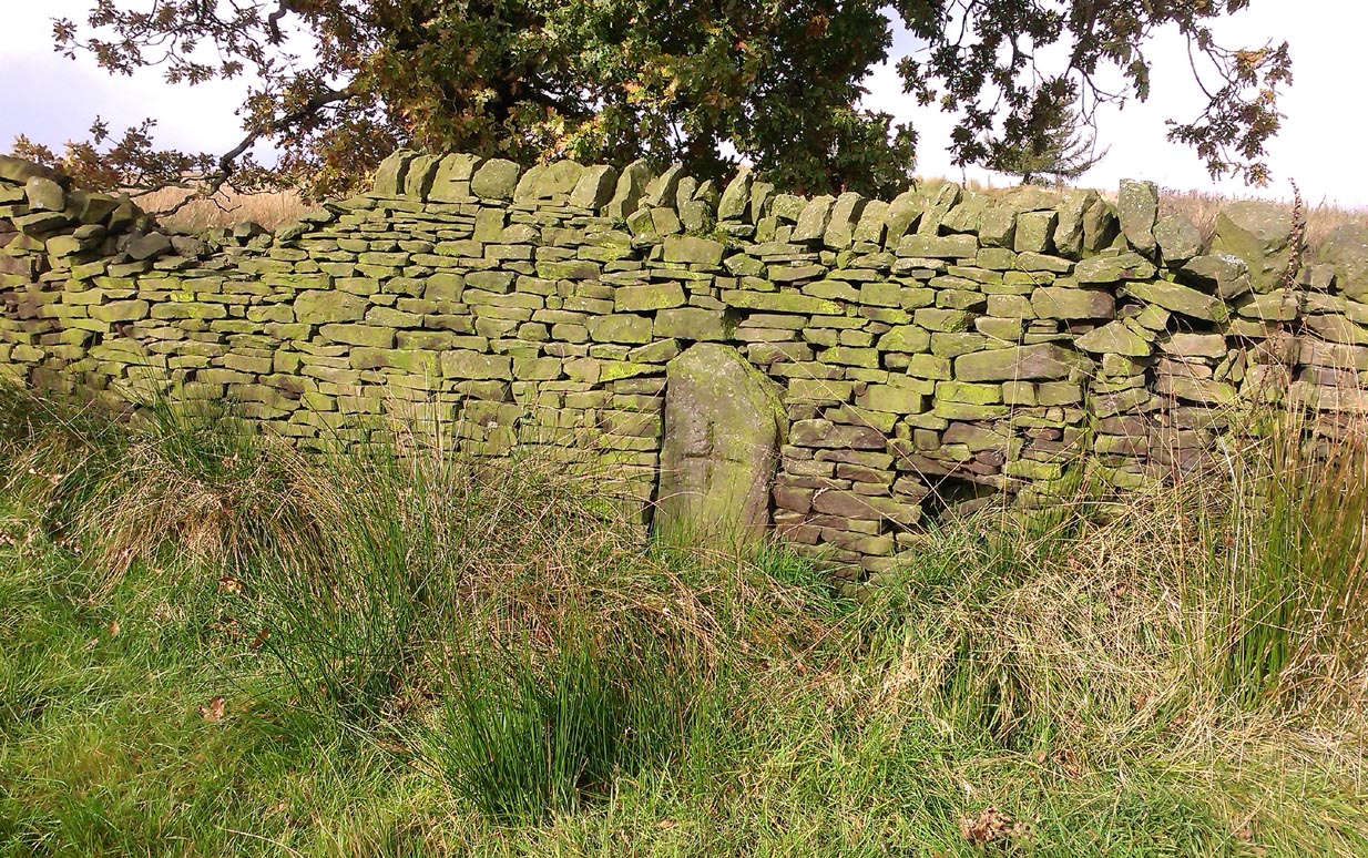
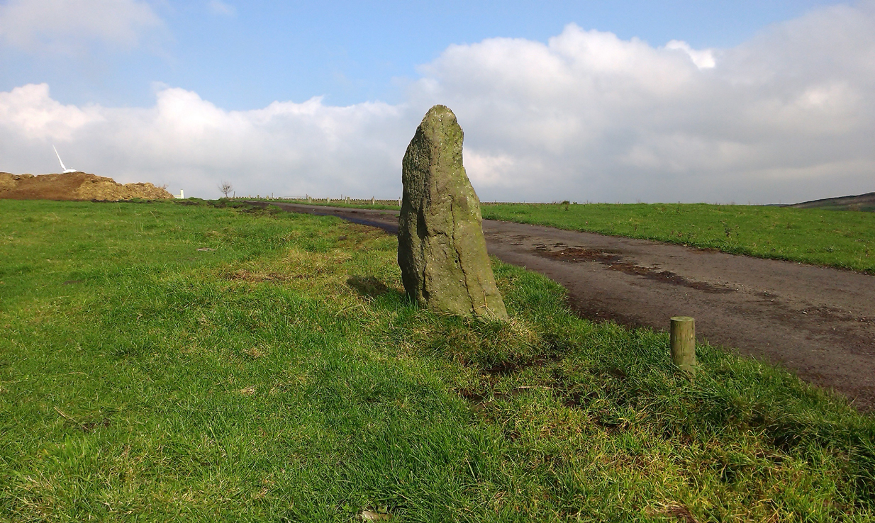
Photo by Phil WaterworthTom Cross, looking N
“Tom Cross is built into the wall hard by Copy House Farm… At the foot of the Copy House Cross is a well, carved out of a solid block of stone. The water apparently trickles into the well from a spring at the back of the wall , and the overflow spills into the field. The top section of the cross is missing, probably it was vandalized at the time of the Reformation or some time afterwards. It appears that the well was used and probably laid down by the Congregational Church dissenters from the late 17th century. At that time, a law was passed, soon to be repealed, which decreed that every man should attend his Parish Church. This meant that those who wished freedom to practise religion in their own form had to firstly attend the Parish Church and then hold a meeting privately afterwards. At that time, and under those circumstances, it was obviously sensible to meet far away from the Parish Church, and apparently Tom Cross was chosen to meet this need. The children of the Dissenters would be privately baptised in this well at the foot of the monolith into which, a cross was deeply incised.
Tom Cross is mentioned in a lawsuit in the year 1592 and a map exists dated slightly earlier which shows another cross in the area on Greystone Moor near Blacko…”
Tom Cross stone
Byrne suggested that the name ‘Tom Cross’ relates to a boundary cross, but this is not substantiated in local dialect or place-name surveys (who say nothing!). Instead, Joseph Wright (1905) gives us the possibility of Tom being simply, “a kind of rock”; although a variety of other associations relate it children’s games, customs and goblins. The word may derive from the Gaelic ‘tom’, relating to a mound, or clump, or knoll in the landscape (Watson 1926). I’d go for one of these misself. Makes sense.
References:
Byrne, Clifford H., “A Survey of the Ancient Wayside Crosses in North East Lancashire,” unpublished manuscript, 1974.
Taylor, Henry, The Ancient Crosses and Holy Wells of Lancashire, Sherratt & Hughes: Manchester 1906.
Watson, W.J., The Celtic Placenames of Scotland, Edinburgh 1926.
Wright, Joseph (ed.), English Dialect Dictionary – volume 6, Henry Frowde: Oxford 1905.
Acknowledegments: Big thanks to Chris Swales for guiding me to the site; and to the old Teddy Man, DannyTiernan.
From Colne or Laneshaw Bridge, head up the Skipton Old Road which heads up towards Bleara Moor (with its prehistoric cairns). Way before that though, about 100 yards before you reach the Black Lane Ends pub, turn left up the track to Jerusalem Farm. Go past it, through the gates and keep on the track until, another coupla hundred further uphill, you’ll see it on the skyline ahead of you…
Archaeology & History
There appears to be no previous reference to this standing stone, found high upon the lonely ridge beside the old track that runs between Laneshaw Bridge and Kelbrooke and Earby. Well eroded on all sides, it isn’t shown on the early or recent maps and has evaded the archaeological registers of the area (but this is Lancashire, where archaeology has been damn lazy on the county’s prehistoric relics until very recently). It may have been laid down for an age, only recently resurrected—we simply do not know. Standing nearly five-feet tall, on its top western face is what looks like a very faded cup-marking, but this may be a fortuitous Rorscharch. There are no marks or holes in the stone to indicate it has ever been used as a gatepost.
Looking far into the eastLooking northwest
I was guided here by the northern antiquarian and stonemason Chris Swales a few weeks ago and was quite taken aback by its position in the landscape—which is outstanding! Apart from being blocked to the west by the rise of the Great Edge, the views to the north through east and south and superb. On the far eastern skyline rises the legendary Hitching Stone, between which is the seemingly cairn-less Knarrs Hill.
Further north along the track we reach the old Dissenter’s Well and its moving companion, the Tom Cross (which has marked different parts of the Lancashire and Yorkshire boundary). Other than this, we know nothing more. An intriguing spot and well worth visiting!
From Kelbrook village head south past Old Stone Trough then continue as far as the lane goes. Then head eastwards for about 1 mile on footpaths to a building called Laycocks. From here continue east along footpaths for another 1 mile or so until you reach Copy House (now called Hawres Farm). Go to the back of the farm where you will see in the wall a cross-incised boundary stone. At the side there is a square-shaped holy well. (You may need to ask permission at the farm).
Archaeology & History
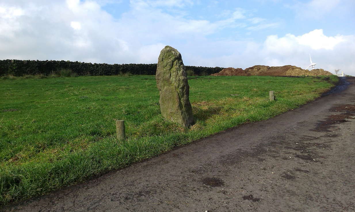
Dissenters Well & Cross (image courtesy ‘QDanT’)
The so-called Dissenters’ Well is a rectangular feature in the ground next to the wall. It is said locally to date from the 17th-18th century, but is most probably an ancient moorland spring. The well was in use from the 17th century by Quakers, Baptists, Methodists and possibly Roman Catholics, at a time when there was much animosity towards non-Conformists. Legislation was passed stopping all illegal gatherings to be held within a 5 mile radius of any church – thus leading to religious gatherings in bleak, remote places on the moorland above towns and villages. In 1812 an Act of Parliament against non-Conformists was repealed and dissenters were given equality regarding where they could worship. The water in the well no doubt had some medicinal qualities or, was a source of spiritual up-lift at the time.
By the well there is 3 foot high pointed boundary stone or waymarker known as ‘Tom’s Cross’ and it has a thin incised cross carved onto it. The stone is partly embedded in the wall. It probably marks the old boundary between Lancashire and Yorkshire. I don’t know who Tom was though he may have been the person who set up the stone. The age of the stone is not known.
To get here, take the same direction as to reach the Bleara Lowe tumulus, stopping a short distance away when you reach the large heap just by the walling where the moorland levels out. Y’ can’t really miss it!
Archaeology & History
Bleara Moor tumulus
Found on the top of the slope above the Bleara Moor Cairnfield, this is quite a large burial mound that seems to have been forgotten on the small moorland heights above Earby and Lothersdale. No archaeological excavation has been done here and there seem to be no accounts of any finds in local antiquarian records. When we visited the place it was very overgrown and covered in heather, but it stood out in the open landscape. Slightly larger than its more famous companion to the east, this tomb stands three- to four-feet high on average, with a diameter of around 25 yards on its longest northeast/southwest axis. Consistent in structure with the larger cairns on Burley Moor like the Little Skirtful, this tomb was probably built in the Bronze Age. It also seems that a lot of stone has been robbed from this cairn for use in the local walling. The site was given a minimal description on the Pastscape website, where it was described as:
“Round cairn 230m W of Bleara Howe (sic). Scheduled RSM No 23718. A partly mutilated slightly oval mound of peat and heather-covered stones up to 1.2m high with max dimensions of 23m NNE-SSW x 21m WNW-ESE.”
The views from here are considerable and this probably had some relevance when it was first built, but I’m not aware if an assessment of this aspect of the site has been made. More information about the Bleara Moor tumulus (and its companions!) would be hugely appreciated!
From Earby, go eastwards up the steep moorland Coolham Lane. A coupla hundred yards up past the little reservoirs on your right there’s a tall, large wooden stile to climb over, up the old heaps of quarried stone and onto the flat moorland plain of Bleara Moor. You’re here! If the heather’s grown back however, you’ve no chance of seeing ’em!
Archaeology & History
One of at least a dozen small cairns on NW of Bleara Moor
When we came up here the other day (ostensibly to check out the great Bleara Lowe tombs on top of the moor), a grey wet day scattered its more darkened light across the moor, which thankfully had been burnt back a few months previous. If this hadn’t happened, we’d have never seen what we found: a scattering of at least a dozen small single cairns, typical of those found on the upper and lower slopes of Green Crag Slack on Ilkley Moor. They’re on the lower northwest-facing plain of Bleara Moor and all are roughly the same size: about 3 yards by 3 yards across and only a foot or two in height, much overgrown in peat and vegetation. Although we found a good number of these small cairns where the heather had been burnt away, there also seemed to be others in the long heather itself, but this was, of course, hard to say with any certainty. A few more exploratory ventures in and around the moor would be good after the next heather-burning sessions!