Man Stone, Askwith Moor, North Yorkshire

Cup-and-Ring Stone:  OS Grid Reference – SE 16722 50595

Also Known as:

  1. Carving no.516 (Boughey & Vickerman)

Getting Here

Man Stone (by Inmaculada Ibanez-Sanchez)

Truly takes a bit of finding this one!  I s’ppose the easiest way to locate it is by approaching it from the south, from Askwith village, up Hall Lane.  Keep walking up the footpath to Top Moorside Farm; then past it, sticking to the same path.  A hundred yard or so past here we get onto the moor itself.  As you hit the moor, you’ll see that the land rises slowly ahead of you: this is Hollin Tree Hill and you need to walk up here (don’t do this in the summer as it’ll be covered in bracken and you’ll not find a damn thing!).  Just before the land starts to levels-out at the top of this small rise, you’ll come across some hut circles.  You’re here!

Man Stone
image courtesy of Graeme Chappell

You can also come to this carving via the Askwith Moor parking-bit, then walk along the well-trod footpath, past the triangulation pillar of Shooting House Hill for a coupla hundred yards, then walk straight south into the moor.  But to those of you who aint got the nose for it, there’s no footpaths here and some folk might easily lose their way.  However, if you reach the rise of Hollin Tree Hill a few hundred yards down the moor, watch out for those same hut circles mentioned elsewhere atop of the rising land.  You’re damn close!

Archaeology & History

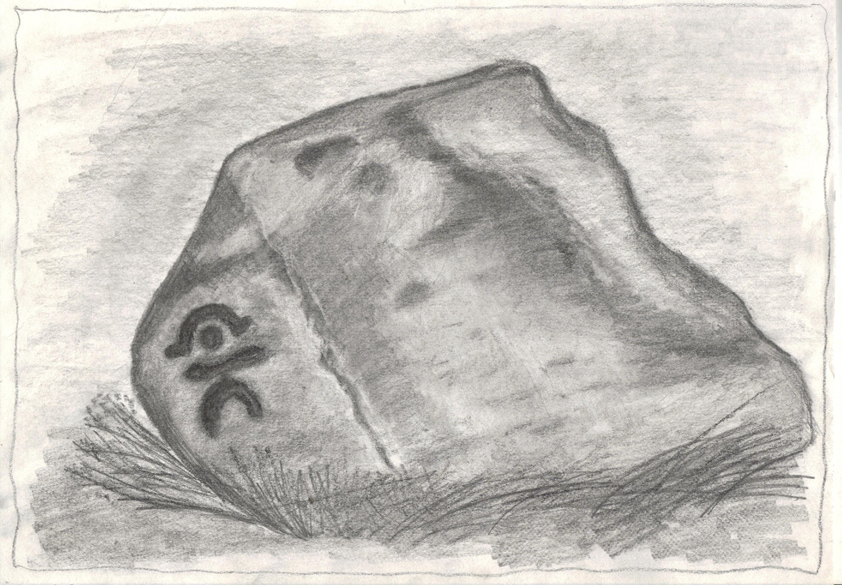
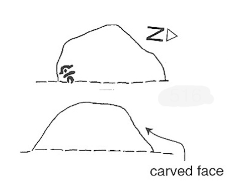
One of my very favourite cup-and-ring carvings this one!  It was discovered about 1991 when Graeme Chappell and I were on one of our many archaeology wanderings, seeking out prehistoric remains on the moors north of Ilkley.  First described and illustrated in Bob Trubshaw’s (1996) archaeomythics journal, it was later included in The Old Stones of Elmet (2001: 149-152).  But when we first found it, this carving – on the vertical face of a small stone, beside an unexcavated hut circle – sent me a bit crazy, as the ‘human’ image in the carving struck me immediately. Needless to say, Graeme was all calm about it while I jumped around like an excited tit!  As far as we’re aware, this is the earliest representation of a human figure in the British Isles.  There are several other contenders in cup-and-ring design, but this seems the most probable of the lot.  Graeme Chappell took a rubbing of the stone several years after we’d found it and the outline clearly shows the image of a human figure.  The carving was later catalogued by rock art students Boughey & Vickerman (2003) in their  Yorkshire survey as ‘stone 516.’  A female compatriot, the Woman Stone, can be found a few hundred yards east of here, at the bottom of the slope by the near horizon.

The fact that the carving occurs on the southern vertical face of a prehistoric hut circle may have had some significance about the structure itself.  Petroglyphs on hut circles are rare—and this one occurs right at the entrance to the structure, the door into the circle.  It may represent an image of the person who lived in this hut circle, or perhaps symbolized the nature of the character living there.  The carving shows that the person was wearing a head-dress, akin to a horned-man figure – but much much earlier than anything previously recognised in British iconography.  The figure may well be a shaman who, perhaps, lived at this circle.  The carving was probably painted in lichens and other dyes

The Man Stone carving
Boughey & Vickerman sketch

Be careful not to wander around looking for this when there’s fog on the hills.  You’re unlikely to find it!  On an excursion up here several years back with Prof. Thomas Dowson and students from the Southampton University Rock Art course, we wandered about all over the place in the dense fog but were unable to find the damn thing!  Twas a bittova freaky day, as half the students started crying (they thought I’d got them truly lost in the middle of nowhere as I didn’t have a map, a compass, walking boots, etc – which is how I usually do my wanderings, but they weren’t to know that!) and we must have walked within 10 yards of the carving, but it remained hidden from our prying eyes.  But if you like your rock art, check this one out!

References:

  1. Bennett, Paul, The Old Stones of Elmet, Capall Bann: Milverton 2001.
  2. Boughey, Keith & Vickerman, E.A., Prehistoric Rock Art of the West Riding, WYAS 2003.
  3. Trubshaw, Bob, “Unique British Anthropomorphic Rock Carving”, in At the Edge, no.4, December 1996.

© Paul Bennett, The Northern Antiquarian


Druid’s Well, Bingley, West Yorkshire

Sacred Well:  OS Grid Reference – SE 09394 39894

Getting Here

If you’re a bittova unhealthy dood, give this site a miss, as it takes a bitta getting to!  Otherwise, get to the rocks at the very bottom of the Druid’s Altar and walk to the right (east) until you hit the walling a few hundred yards along.  Near the bottom of the slope, where the land levels out, there are several lovely moss-strewn boulders in their music of graceful hues.  One of them, you’ll see, has water emerging from it base.  You’re here!

Archaeology & History

The Druid's Well, Bingley
The Druid’s Well

I first visited this old site with the holy wells writer Edna Whelan sometime in the early 1980s, when we went in search of the sacred spring of water known as the ‘Altar Well,’ shown on early maps to be just a short distance beneath the small cliffs called the Druid’s Altar.  We didn’t find it!  Another visit with Graeme Chappell and Edna (again) sometime later also proved fruitless – but something else was found which we didn’t know about on our first sojourn: the Druid’s Well, or more accurately the Druid’s Spring. (no stone trough y’ see)  Not far from the spot that the Altar Well could once be seen, this beautiful spring of sweet water emerges beneath the rich lichen-encrusted boulder, painted with dappled mosses and an overhang of vivid ferns.  Tis a fine oracular site, if ever there was one!

The waters run slowly from beneath the great old rock, upon which grows a fine specimen of a birch tree – a truly old thing!  And if there was ever any truth about this regions association with the druids, one of their most important sacraments grows profusely here when the season is right: no, not mistletoe (though it can be found sparingly upon the old oaks), but a wealth of the sacred Amanita muscaria, to whose spirit visionary journeys were bestowed.

Close-up of the waters beneath the boulder

The name of the woodlands in which our Druid’s Spring emerges — the Hollin Wood — might also have had some associative relationship with this well, or the Altar above (modern maps call it the Hollin Plantation, as much of the old woods have been felled and copsed by modern man).  Place-name texts ascribe this to be the ‘woodland of holly trees’, but during our wander through the woods a few weeks ago (when we got the photos of the Druid’s Well) holly trees were not common.  It may be that the Hollin Wood originally derived from ‘holy wood’, as this old well and the Druid’s Altar above would have surely made the site sacred to the druids.  Just a thought.  We will probably never know (if someone finds out for sure, one way or t’other, lemme know and I’ll amend where necessary!).

References:

  1. Greenbank, Sydney, The Druid’s Altar, Bingley, R.G. Preston: Bingley 1929.
  2. Speight, Harry, Chronicles and Stories of Old Bingley, Elliott Stock: London 1898.
  3. Whelan, Edna & Taylor, Ian, Yorkshire’s Holy Wells and Sacred Springs, Northern Lights: Dunnington 1989.

© Paul Bennett, The Northern Antiquarian


Great Skirtful of Stones, Burley Moor, West Yorkshire

Cairn: OS Grid Reference — SE 14053 44541

Also Known as:

  1. Great Apronful of Stones

Getting Here

Various routes to this giant tomb, which happens to be a way off the roads (thankfully!). Probably the easiest way is from the Menston-side: up Moor Lane, turn left at the end, go 200 yards and take the track onto the moor. Just keep walking. If you hit the rock-outcrop nearly a mile on, you’ve gone past your target. Turn back for about 400 yards and walk (south) into the heather. You’re damn close!

Archaeology & History

The Great Skirtful of Stones cairn looking east to Otley Chevin
Great Skirtful of Stones cairn looking east to Otley Chevin

Due north of the Skirtful Spring water source, this is one of Ilkley Moor’s major prehistoric sites: ‘major’ for a number of reasons – not least of which is the size of the thing!  Although getting somewhat overgrown these days as more of the heathlands encroach the mass of rocks that constitute the central ‘tomb’, it is still a formidable heap. Another reason this site is of importance is its position in the landscape: it can be seen as the peak or ‘nipple’ on the landscape from considerable distances north, south and east of here, rising up on the horizon and catching the eye from many miles away. This was obviously quite a deliberate function of the site when it was first constructed – thought to be in the Bronze or Iron Age period (sadly we have no decent excavation here to tell us just when it was made). Another reason for its importance is its position relative to a once huge prehistoric graveyard immediately east. And right next to it we also find a curious circular monument that has never been properly excavated, whose function is unknown. It is also the seeming focal point of at least one, though possibly three prehistoric trackways: one of which goes right past it, though swerves on its southern edge quite deliberately so as to not touch the monument. This trackway appears to have been a ceremonial ‘road of the dead,’ along which our ancestors were carried, resting for some reason at the nearby Roms Law, or Grubstones Circle, a few hundred yards to the west.

Wrongly ascribed as a “round barrow” by archaeologist Tim Darvill (1988), the Great Skirtful cairn was named in boundary changes made in 1733, where one Richard Barret of Hawksworth told that the site was “never heard go by any other name than Skirtfull of Stones.”

In 1901 there was an article in the local ‘Shipley Express‘ newspaper — and repeated in Mr Laurence’s (1991) fine History of Menston and Hawksworth — which gave the following details:

“Mr Turner led the way across Burley Moor to the Great Skirtful of Stones, a huge cairn of small boulders, nearly a hundred tons on a heap, although for centuries loads have been taken away to mend the trackways across the moor… The centre of the cairn is now hollow, as it was explored many years ago, and from the middle human bones were taken and submitted to Canon Greenwell and other archaeologists” – though I have found little in Greenwell’s works that adequately describe the finds here. Near the centre of the giant cairn is a large stone, of more recent centuries, which once stood upright and upon which is etched the words, “This is Rumbles Law.” The Shipley Express article goes on: “Mr Turner explained that ‘law’ was always used in the British sense for a hill, and Rumbles Hill, or cairn, was a conspicuous boundary mark for many centuries. He had found in the Burley Manor Rolls, two centuries back, that on Rogation Day, when the boundaries were beaten by the inhabitants, they met on this hill, and describing their boundaries, they concluded the nominy by joining in the words, “This is Rumbles Law.””

Great Skirtful on 1851 map

Several other giant cairns like this used to be visible on the moors, but over the years poor archaeological management has led to their gradual decline (and in editing this site profile in 2016, have to report that poor archaeological and moorland management is eating into and gradually diminishing this monument to this day).  We still have the Great Skirtful’s little brother, the Little Skirtful of Stones, a half-mile north of here.  The very depleted remains of the once-huge Nixon’s Station giant cairn can still be seen (just!) at the very top of Ilkley Moor 1½ miles (2.65km) west.*  And we have the pairing of the giant round cairn and long cairn a few miles west on Bradley Moor, near Skipton.  The tradition of such giant tombs on these hills was obviously an important one to our ancestors.

Folklore

We find a curious entry in the diaries of the Leeds historian Ralph Thoresby, in the year 1702, which seems to describe the Great Skirtful of Stones, adding a rather odd bit of folklore. (if it isn’t the Great Skirtful, we’re at a loss to account for the place described.) Mr Thoresby told how he and Sir Walter Hawksworth went for a walk on Hawksworth’s land and said how,

“he showed us a monumental heap of stones, in memory of three Scotch boys slain there by lightning, in his grandfather’s, Sir Richard Hawksworth’s time, as an old man attested to Sir Walter, who being then twelve years of age helped to lead the stones.”

As far as I’m aware, this old story of the three Scottish boys is described nowhere else.

Like many giant cairns, the Great Skirtful has a familiar creation myth to account for its appearance. In one version we hear that it was made when the local giant, Rombald (who lived on this moor) and his un-named wife were quarrelling and she dropped a few stones she was carrying in her apron. A variation swaps Rombald’s wife with the devil, who also, carelessly, let the mass of stones drop from his own apron to create the ancient cairn we still see today.

According to Jessica Lofthouse’s North Country Folklore (1976), a Norse giant by the name of Rawmr, “fell fighting against the Britons of Elmet and is buried, they say, on Hawksworth Moor” – i.e., the southeastern section of Rombald’s Moor, very probably at the Great Skirtful of Stones.  I’ve yet to explore the history and etymology of the name Rawmr…

References:

  1. Bennett, Paul, The Old Stones of Elmet, Capall Bann: Chieveley 2001.
  2. Cowling, Eric T., Rombald’s Way, William Walker: Otley 1946.
  3. Darvill, Timothy, Ancient Britain, AA: Basingstoke 1988.
  4. Laurence, Alastair, A History of Menston and Hawksworth, Smith Settle: Otley 1991.

* Whoever is/was supposed to be responsible for the care of the Nixon’s Station giant cairn monument should be taken to task as it’s been virtually obliterated since when I first came here 30 years ago.  Which useless local archaeologist and/or council official is responsible for its destruction?  Who allowed it to happen?  Why are Ilkley Moor’s prehistoric monument’s being so badly looked after by those who are paid to ensure their maintenance?  Are their heads up their arses, in the sand, or—don’t tell me—the prawn sandwiches are to blame!?

© Paul Bennett, The Northern Antiquarian

Clach Brath, Baile Mor, Iona

Bullaun Stone:  OS Grid Reference – NM 286 244

Also known as:

  1. Clacha Brath
  2. Clachan-nan-Druidhean
  3. Day of Judgement Stone
  4. Druid’s Stone
  5. World’s End Stone

Folklore

On this curious, broken, basin-shaped rock — thought by some to have at one time played a part in an old cross whose remains are in the Abbey Museum — are two deep cup-shaped hollows, in which were once “three noble globes of white marble” that were used for oracular purposes and were said to have originated in druidical rites.  In Miss McNeill’s (1954) survey of the island, she tells that:

“near the edge of the path leading to St. Oran’s Chapel, there lies a broad, flat stone, with a slit and a cavity on its surface. Here there used to lie some small round stones which pilgrims were wont to turn sunwise within the cavity; for it was commonly believed that the ‘brath’, or end of the world, would not arrive until this stone should be worn through.”

The small stones that were once in the Brath were ordered by the Church to be thrown into the sea; but local folk replaced them with three other small stones, maintaining the traditional rites of this stone until they eventually stopped sometime in the 19th century.  But in Major-General James Forlong’s (1906) study, he tells of a somewhat earlier mythic origin to this old stone, saying:

“In Iona the Druids are said to have made the flat altar stone called Clachan-nan-Druidhean, or Druid’s Stone, the stone of fate or of the last day, with round stones fitted into cup hollows on the surface, which the pious pilgrim turns round.  The world will end when the stone is worn through.  The Culdee monks preserved this monument.”

And what little is left is still preserved to this day.  The curious “end of the world” motif was something that was grafted onto an earlier mythos: what Mircea Eliade called the “myth of the eternal return”, wherein Nature’s annual cycle —from birth, life to death and subsequent renewal, endlessly, through the seasons—was the original status, later transmuted by the incoming judaeo-christian cult of linear time and milleniumism relating to a literal “end of the world” when their profane myth of Jesus returning to Earth occurs.  We might also add that the stones which once rested into the hollows of the Clach Brath would likely have possessed divinatory and healing qualities, as comparatiove studies suggest.

References:

  1. Eliade, Mircea, The Myth of the Eternal Return,
  2. Forlong, J.G.S., Faiths of Man – volume 1, Bernard Quarithc: London 1906.
  3. Holder, Geoff, The Guide to Mysterious Iona and Staffa, Tempus: Stroud 2001.
  4. McNeill, F. Marion, Iona: A History of the Island, Blackie & Son: Glasgow 1954 (4th edition).

© Paul Bennett, The Northern Antiquarian


Clach a’ Phoanais, Strontian, Inverness-shire

Standing Stone:  OS Grid Reference – NM 81581 61360

Also Known as:

  1. Branks Stone

Getting Here

As you enter the village from the east, onto the A861 road, the Strontian Hotel is on the right-hand side of the road and you can’t fail to notice. Stop!

Archaeology & History

Clach a’ Phaonais on 1872 map

Shown on the first edition OS-map of the region in 1875, this old worn standing stone, more than six-feet tall, can be seen at the edge of the drive.  There’s an iron ring is attached to it, which I thought might have made it an old Bull Stone in bygone days, but no such lore is remembered.  Also known as the Branks Stone, it’s Gaelic name probably means the ‘stone of penance,’ and folk were chained to it in eaelier days for bad behaviour.  It was widespread across the Highlands to tie criminals to stones and wooden poles, naked, for 24 hours and let the midges get to them.  Crime was down to a minimum up here!

Folklore

As the locals at Strontian Hotel told me (thanks Finlay), “several stories have emerged locally. It marks a clan chief’s grave, a sighting stone for the equinox but the most plausible one is based on the fact that there is an iron ring on the side of the stone facing the loch and it was used to tie up barges taking lead from the local lead mine.  It supplied the raw material for shot during the Napoleonic and Crimean wars.”

Aknowledgements:  Big thanks to Anne and the Megalithic Portal for additional help on this one.

© Paul Bennett, The Northern Antiquarian


Buckton Castle, Mossley, Lancashire

Hillfort:  OS Grid Reference – SD 9892 0161

Archaeology & History

Buckton Castle on 1882 map

This giant site—deemed as Iron Age by some and medieval by others—is on the verge of complete destruction as the adjacent quarrying company cuts closer and further into the sides and top of the monument. Local people and archaeologists need to do something about this, or it will be lost forever as the Industrialists once again destroy more of our ancient heritage in order that they can feed their god of Money.

Folklore

Legend has always told that great treasure existed beneath the grounds of this Brigantian hillfort, found on the moor-edges to the east of Manchester. Long ago, one man came along to see if he could find the treasure, said to consist of a huge chest of gold. The man brought two horses and the ground within the fort was gradually cleared away until, to the man’s surprise, the legendary chest was revealed!

Attaching chains to it and the horses, the man shouted:

“Gee, whoa, whoo! Bonny, Buck and Bell,
I’ll have this chest o’ gowd, i’ spite o’ all t’ devils in hell!”

But barely had the words left his mouth and the chest began to move, when the devil himself appeared in the shape of a huge hen that breathed fire! This scared the horses so much that they bolted and snapped the chains, taking their master with them but leaving the treasure-chest still in the ground. To this day the chest still remains, hidden in the Earth.

References:

  1. Winterbottom, Vera, The Devil in Lancashire, Cloister: Stockport 1962.

© Paul Bennett, The Northern Antiquarian


Brotton Howe, Brotton, Cleveland, North Yorkshire

Cairn (destroyed):  OS Grid Reference – NZ 6950 1886

Archaeology & History

Frank Elgee’s 1930 plan

Another old site that has sadly succumbed to that bollox called ‘progress’! It’s in the North Yorkshire region some halfwits have taken to calling Cleveland — but which a lotta local folk still correctly call Yorkshire.  But that aside…

In an article by local students William Hornsby and Richard Stanton written in 1917, we find that this was just one of at least seven hillocks presumed to be barrows here — but all the others had gone even in their day.  When Crawford (1980) came to survey the site in the late 1970s, he told that,

“this large barrow is now only visible as a low swell in an arable field… (but) the profile of the barrow is retained in the hedgeline that bisects it from north to south, but the whole of its eastern half has been obliteratd by the Brotton-Kilton road.”

Elgee’s 1930 photo of one of the carvings
E.T. Cowling’s drawing of one of the carvings

When Hornsby and Stanton checked the place out it measured 54 feet in diameter and had an extensive covering of small stones, like a large cairn, with a single grave at the centre, aligned north-south; and a tree-trunk coffin on the southwestern side.  Of the stones which filled the central grave, eight of them were found to have cup-markings on them; whilst 16 stones covering the tree-trunk grave also possessed cup-markings. Roughly equidistant between the two burials was another stone found to be resting face-down on the original ground-level, and covered with 20 cups and 5 cup-and-rings!  Awesome stuff!

G.M. Crawford’s (1980) description of the site was as follows:

“Howe Hill was excavated by Hornsby and Stanton in 1914; they discovered that the mound was made up with a clay floor, overlain by ‘a cairn 30 feet long and 3 feet high’ of diorite cobbles, capped by a layer of earth. Cut into the clay floor were two graves: the first was oriented north-south and measured 2m long by 0.9m wide at the old land surface and was 0.7m deep. The grave was filled with ‘medium sized stones’ with a ‘thin dark layer,’ thought to be an inhumation burial, on the floor; 8 of the stones bore cup-marks. The second grave, oriented northeast-southwest, was 2.5m long by 0.9m wide at the old ground surface, reducing to 1.8m long by 0.5m wide at its bottom, 1.3m below. This grave, which was filled with stones, also contained a tree-trunk coffin or oak, measuring 1.5m long… At the head (northeast) were found the unburnt skull fragments of a man laid on its right side. Unaccompanied cremations had been placed at both ends of the coffin. 16 cup-marked stones were among the infill of the grave.”

This was obviously a site of considerable importance and it’s a huge pity (if not a disgrace) that today no trace of the site remains.

References:

  1. Cowling, Eric T., Rombald’s Way, William Walker: Otley 1946.
  2. Crawford, G.M., Bronze Age Burial Mounds in Cleveland, Cleveland County Council 1990.
  3. Elgee, Frank, Early Man in North-east Yorkshire, John Bellows: Gloucester 1930.
  4. Hornsby, William & Stanton, Richard, “British Barrows near Brotton,” in Yorkshire Archaeology Journal, 24, 1917.
  5. Smith, A.H., The Place-Names of the North Riding of Yorkshire, Cambridge University Press 1928.

© Paul Bennett, The Northern Antiquarian


Beinn na Cailleach, Islay, Argyll

Sacred Mountain:  OS Grid Reference – NR 450 596

Also Known as:

  1. Beinn na Caillich

Folklore

Another great mountain of the ‘Old Woman’: primal creation deity of these hills. Whether she holds sway over the land here for many months, as she does on Mull and Skye, I cannot find.  One creation legend here tells that one of the furrows down the side of the mountain – called Sgrìoh na Caillich – was said to be made by her as she slid down it in a sitting position. The small loch on the way up to her summit – Lochan na Caillich – was one of her washing places; and the Beinn na Caillich Beag, immediately east, speaks of other legends, now seemingly lost to us.  It’s highly likely that some of the megalithic remains nearby had some mythic relationship with this old hill, though I aint found any studies along these lines…yet!

© Paul Bennett, The Northern Antiquarian


Hood Hill Stone, Kilburn, North Yorkshire

Legendary Rock:  OS Grid Reference – SE 503 812

Getting Here

From Kilburn village, take the north road up past the church for about 300 yards, bearing up the track on your left and walk up into the wooded hill a mile ahead of you.  It’s in there!

Folklore

In this region there’s a teeming cluster of druid, fairy, devil and spook-lore, along with numerous prehistoric remains. Not sure this site has such an archaic pedigree, though the creation myth told of this rock (marked on the 1st edition OS-map as an antiquity) seems to imply as such. Our old devil disguised himself as a druid many moons ago in an attempt to gain favour with the old priests, but was discovered in his plans and so, in anger, flew out across the hills carrying a great stone with him which he dropped from the skies and it landed where the Hood Hill Stone still remains. Also in anger he jumped down and stood on the great rock, and in doing so left his footprint impressed upon the stone. (There’s the possibility this is an unrecognised cup-marking – having not been here I can’t say misself).  Edmund Bogg (1906) also tells us that,

“The monk’s hood-like configuration of the crest is said to have originated its name. The busy tongue of tradition, however, says that the name commemorated Robin Hood who, with his merry men, affected the hill-fastnesses hereabouts; but the hill was named ‘Hode’ long, long before the famous Robin came this way at all.”

The same writer also told how,

“legend, too, has it that the happy valley just north of Hood Hill…was a secluded and sacred retreat of the druids, and at the introduction of christianity into these parts, a great assembly gathered to consider which of the two religions should in future be adopted.”

Yet another legend – and an old one, says Bogg – is “that when the dinner-bell rang at Osgodby Hall the stone rolled down for its repast, and regularly returned to the crest after the meal.”

It’s blatantly obvious that something of antiquity this way hides.  The “enclosure” shown on the modern OS-maps here could do with being looked at little closer.

References:

  1. Bogg, Edmund, Richmondshire and the Vale of Mowbray (volume 1), James Miles: Leeds 1906.

© Paul Bennett, The Northern Antiquarian


Ardlamey, Gigha, Argyll

Cairn:  OS Grid Reference – NR 63091 48258

Also Known as:

  1. Canmore ID 38524

Archaeology & History

A decent-sized cairn, around 50 feet across (even though much of the stone has been nicked) and about 3 feet high, with a singular large cist near its centre. When the Scottish Royal Commission lads checked the place out in 1967, at least four of the kerb stones were still in situ (on its north, west and southwest sides) – the tallest being its northern stone, more than 6 feet high. The northern stone also had a peculiar deposit of white quartz and pebbles laid at the base, placed there quite deliberately – unlike the others which rested on a level of sand and gravel.

The Scottish Royal Commission (1971) also reported the former existence of two cists not far from here, “uncovered by the plough during the 19th century on the farm of Ardlamey”: one at NR 637 484, and the other at NR 635 484.

References:

  1. Royal Commission on the Ancient & Historical Monuments of Scotland, Argyll – Volume 1: Kintyre, Glasgow 1971.

© Paul Bennett, The Northern Antiquarian