Cross (destroyed): OS Grid Reference – SJ 2534 7208
Archaeology & History
Actual location of the cross
This long-gone site, described in the Domesday Record of 1086 as Atiscros Hund, (or “hundred”, which is the word given to an administrative division of land which, at that time, was on the western edge of Cheshire bordering Wales), gained its title from an old English personal name, Æti. The fact that it stood on an ancient boundary and was included in Domesday, means it would have been a stone cross. Its location was shown on the 1871 Ordnance Survey map (and several subsequent ones), based on traditional accounts about its position. The site is still preserved in local street-names.
Referring to the monument itself, Thomas Pennant (1796) said that it still existed in his day, telling that,
“A cross stood there, the pedestal of which I remember to have seen standing. There is a tradition that, in very old times, there stood a large town at this place; and, it is said, the foundations of buildings have been frequently turned up by the plough.”
References:
Dodgson, J.M., The Place-Names of Cheshire – volume 4, Cambridge University Press 1972.
Pennant, Thomas, The History of the Parishes of Whiteford and Holywell, B. & J. White: London 1796.
Taylor, Henry, Historic Notices, with Topographical and other Gleanings Descriptive of the Borough and County-Town of Flint, Elliot Stock: London 1883.
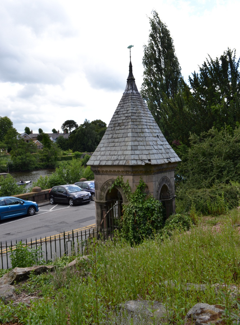
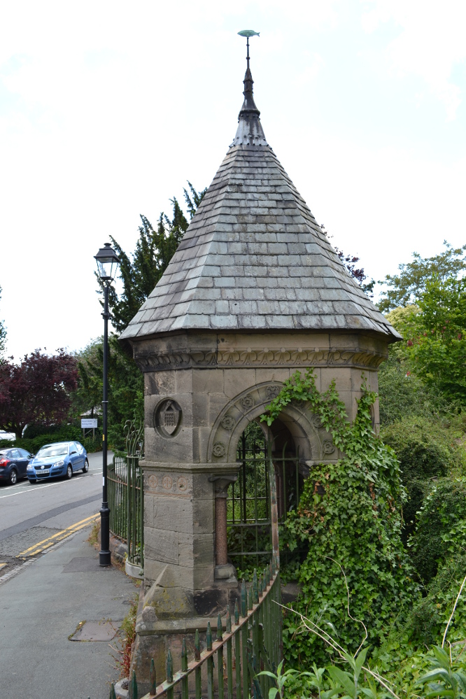
The well is found on the south-east corner edge of Grovesnor Park, which is the south-east of the city beside the River Dee.
Archaeology & History
Billy Hobbys Well, Chester
An early reference to this site is in the place-name of Billy Obbies Field, marked in 1745, with an accompanying spring marked at 1791. This would appear to suggest that the spring gained its name from the field and not vice versa, with the name possibly representing a local person. Yet the name may hide a much earlier origin. The name ‘Hobby’ derives from hobb, a name for a devil or demon – and where the name hobgoblin derives from. It may be possible that the area was a marshy waste and to warn people away a legend of a demon was introduced. More interesting is the idea that as the name ‘Hobb’ is synonymous with Puck, and Puck possibly having a Roman origin, that the site could be a much earlier Pagan site. This might explain the fertility ritual found here (see Folklore, below) if it has a greater age. It may be significant that when the park was developed, a long line of Roman earthenware water pipes were found. Did they draw water from the spring?
Internal Structure
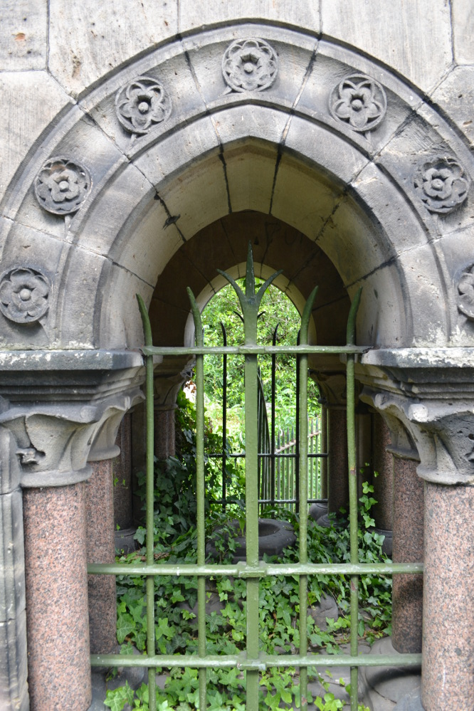
Whatever the origin, when the garden was developed in the 1860s by the 2nd Earl of Westminster, Richard Grosvenor, a rather grand and impressive red and buff sandstone ashlar well house was erected. This was designed by John Douglas, a local Chester architect, who was not forthcoming in making this well grand with canted corners, pointed arches flanked by a granite columns with wrought iron bars. At each corner is a small carved circle containing carved sheafs and portcullis and the voussoirs contain carved roses. A tiled spired roof sits upon the structure with an apex surmounted by a copper fish weathervane. All in all, rather ostentatious for a well – especially as access to the well chamber has not been made very easy by the enclosure. Whether the improvements were done to develop some sort of spa well is unclear, but it is known that the when Canniff Haight (1904) visited for his United Empire, the spring was still flowing and noted, for he records:
“Billy Hobby’s Well,” a spring of excellent water, where we have a drink.”
Folklore
This was a local wishing well. A local anonymous rhyme records:
“I lov’d the tales that idle maids do tell,
Of wonders wrought at Billy Hobby’s Well,
Where love-sick girls with leg immured would stand,
The right leg ’twas – the other on dry land,
With face so simple – stocking in the hand –
Wishing for husbands half a winter’s day.
With ninety times the zeal they used to pray”
This old rhyme despite some pedigree suggested I have been able to date only to 1823. It appears to record a ritual undertaken at the well, a similar ‘one part of the body in, one out’ was done at Walsingham by lovelorn maidens, but it does look to be Victorian in origin there (or at least post Reformation). The only problem with the practice being undertaken then is that the present structure dates from that period.
From the forthcoming work on Holy wells and healing springs of Cheshire
References:
Dodgson, J.M., The Place-Names of Cheshire – Part 5, English Place-Name Society: Cambridge 1981.
There appear to be no records of any prehistoric circle of any form in the area less than a mile northwest of Whaley Bridge, where the intriguing place-names of Ringstones Clough and Ringstone farm can still be found, nearly 750 years after first being mentioned in local history records. Described by place-name authority J.M. Dodgson (1970) to be simply a “ring of stones” or “stone ring,” little is said of the place in Aubrey Burl’s standard texts. Thankfully we are helped out by R.A. Barnett, who found a reference to the place in John Barnatt’s (1990) local survey, where he gave us a bit of local lore:
“A local man working at the farm said there was a stone circle under the concrete floor of the buildings and that he had seen a photograph showing men sitting on the stones…….. It is not known how much credence to place on this account, it may well be apocryphal.”
Nobody as yet has located this alleged photo. It would be great if anyone could find it!
The site was first mentioned as early as 1285 AD in records of the Palatinate of Chester, as both ‘Ryngstones’ and ‘Ryngstanes’; then later in the Minister’s Accounts of 1550 as the name we know today. But another document found in the Public Records Office dated 1357 AD describes simply le Rynge, or “the ring” itself perhaps. It is described consistently as the standard place-name in numerous other documents from thereon. Was this a cairn circle? A stone circle? A circular enclosure? And where exactly was it? What monument gave this area of land its name?
Good looking contenders for the position of the circle include both Brownough Hill and Black Hill; and what is the story behind the Dipping Stone, above the original source of Ringstone Clough?
References:
Barnatt, John, The Henges, Stone Circles and Ringcairns of the Peak District, Sheffield Archaeological Monographs 1990.
Dodgson, J.M., The Place-Names of Cheshire – volume 1, Cambridge University Press 1970.
On Thurstaston Common a 298 foot high hill has a large red sandstone outcrop, on the landward side, known as Thor’s Stone. One large rectangular block of stone that is 50 feet in length, 30 feet wide by 25 foot high has been eroded over thousands of years. Described by J.A. Picton in 1877 as “the Great Stone of Thor,” the village itself seemed to have gained its name from this prominent mass of rocks. It was described first of all in the Domesday book, as Turstanetone, and both village and rocks have been written as variants on the original ever since. The place-names writers Mills & Room (1998) ascribe the name to being a “farmstead or village of a man called Thorstein”; but it’s just as likely to derive from “a farmstead of/at Thor’s Stone.” (Harrison 1898) As early landscape features were traditionally equated with animistic and mythic lore, the Viking god Thor is more probable than some unlikely chap called Thorstein.
Local folklore tells that the rock is named after the Norse god Thor – he who causes thunder and lightning. Viking settlers from Thingwell apparently settled here in the 10th century AD and, according to legend, these settlers used the stone as a pagan altar with blood sacrifices taking place here. A creation myth of the site tells that Thor tossed the large stone here in anger; and yet another says that the stone was raised here to commemorate the battle of Brunanburh in 937 AD. In modern more times, Morris dancers meet here and enact their rites on Mayday mornings.
The outcrop has been eroded away over thousands of years by the weather, post glacial erosion and even quarrying, leaving strange shapes, features and projections in the soft sandstone. There is much recent graffiti to be seen all over the rock, especially on the summit and sides including one set of graffiti carved by Professor Taylor in 1879. There used to be a “fairy well” near the stone but this disappeared long ago. Children took flowers to the well to decorate it, while adults visited it to receive a cure for various ailments of the body. At nearby Thurstaston Hall, Christina Hole (1937) reported there lived the ghost of a troubled woman.
References:
Harrison, Henry, The Place-Names of Liverpool, Elliot Stock: London 1898.
Hole, Christina, Traditions and Customs of Cheshire, Williams & Norgate: 1937.
Mills, A.D. & Room, Adrian, A Dictionary of English Place-Names, Oxford University Press 1998.
Many churches strive to find evidence in the greater antiquity of their foundations than the industrial age; and even those whose origins are medieval hope to find much older roots. Such is the case with this Norman church of St. Peter, where just such an antiquity was found in the middle of the 19th century, embedded in the old walling where it had been encased many centuries before. Thought to have been carved around the 8th century, the design on the stone typifies much ‘Celtic’ art, as it tends to be called, such as are found all over northern England. As we can see here, the main feature is a series of curved and interlocking lines covering most of the rock face (sadly, no swastika occurs on this stone, but it’s common on many others of this period). The old vicar of the church — Harold Rogers — takes up the story:
“About the year 1841, when part of the chancel work was taken down, some fragments of curiously ornamented sandstone were discovered embedded in the masonry. They were carefully removed, put together, and placed in the churchyard where, protected from injury by a glass case, they may now be seen. The carved ornamentation on this ancient relic was probably executed about the 8th century, and it is conjectured that the stone formed part of a cross placed there by some early Saxon converts…to commemorate the spot where the gospel was first preached in this locality.”
A brass inscription attached to the encased carved stone informs the visitor the same information. The proximity of this early carved stone to the River Bollin and, very probably, an ancient ford crossing, implies the waters here were held as sacred in ancient days and hence the supplanting of the ornate carved cross at this position in the landscape.
References:
Rogers, Harold W., Prestbury and its Ancient Church, Arthur Clownes: Macclesfield n.d. (c.1960)
In Roeder & Graves’ (1906) analysis of the neolithic remains surrounding this geological arena, they told there to have been “at least nine wells at different parts of the Edge” — this and the Wizard Well being the ones of greater local renown. Flints and the remains of neolithic man were found all round here. Obviously the water from this well here would have been of primal use.
Folklore
In 1843, Robert Bakewell told how the waters from this famed well, “are said to be a cure for barrenness.” As well as this he reported how a large boulder fell from the Holy Well Rocks above it around 1740, and “a woman and a cow are said to have been buried under it.” But a lengthier description came from Roeder & Graves’ archaeological essay, where they told how both the Wizard Well and this site, “were in ancient times connected with well worship.” They continued:
“Their healing powers were considered to be unfailing: the barren, the blind, the lame, and bodily-afflicted constantly made their way thither; maidens whispered their vows and prayers over them, their lovers and their future lives being their theme. Crooked silver coins were dropped into the well, but these have been cleared out long ago. At present time the devotees are satisfied, in their economical habit, to offer mere pins and hairpins; the custom is not yet dead, for some of the immersed pins are still quite corroded and bright. Some of the sex deposit the pins in their straight and original form, others bend them only at right angle, and as many again seem to consider the charm alone to act effectively when carefully and conscientiously doubled-up. Maidens of a more superficial cast just the slightest twist to the object. To judge from the state of corrosion and the old-fashioned, thick globular heads, some of these pins must have been in the well for at least sixty years… There are occasionally to be seen also a few white pebbles in the two wells.”
References:
Bakewell, Robert, Alderley Edge and its Neighbourhood, J. Swinnerton: Macclesfield 1843.
Roeder, C. & Graves, F.S., ‘Recent Archaeological Discoveries at Alderley Edge,’ in Trans. Lancs & Cheshire Antiq. Soc., 1906.

")

