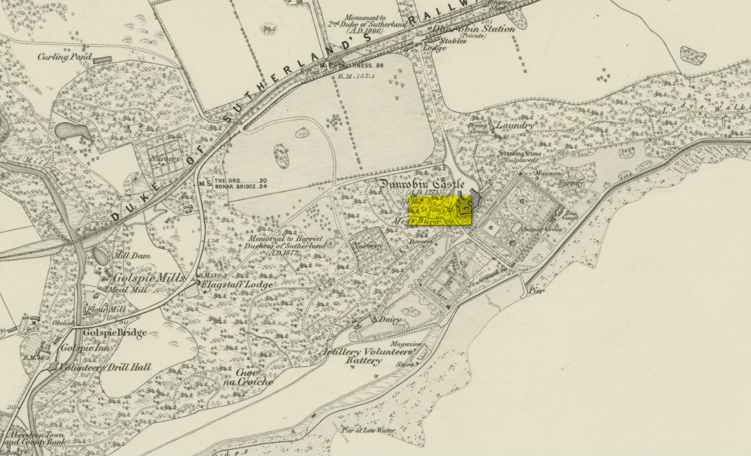
Very little has been written of this site due to the fact that little seems to known about it. A few of the usual ‘official’ on-line catalogues mention it but information on the site is truly scant. It is shown on the earliest Ordnance Survey map of the region and the same cartographers describe it in the Ordnance Name Book (1873), saying briefly how St John’s Well,
“Applied to a very deep pump well situated in the court of the ancient portion of “Dunrobin Castle”. No information respecting the dedication or origin of this name can be obtained in the District.”
But an earlier reference than this is cited in Fraser’s (1892) work, telling us that,
“In the midst of the court within the castle there is one of the deepest draw-wells in Scotland, all lined with ashlar-work, which was built and finished before the house was begun. The well was known as that of St. John. In the year 1512 sasine (i.e. delivery of feudal property) of the earldom and castle was taken at the well. At other times sasine was taken at the castle, at its gates, or near the well.”
Subsequent to this, we read in Cumming’s (1897) definitive folklore work of the region how,
“(it) looks as if there had been a chapel of St. John on Drumrabyn. In that case it may have been one dependent upon Kileain (=Kirk of John) on Loch Brora, which was only ½ a mile further than Kilmalin.”
Having not visited the castle, I’m unsure whether or not the well can still be seen. Does anyone know…?
Fraser, William, The Sutherland Book – volume 1, Edinburgh 1892.
Acknowledgements: Big thanks for use of the 1st edition OS-map in this site profile, Reproduced with the kind permission of the National Library of Scotland.
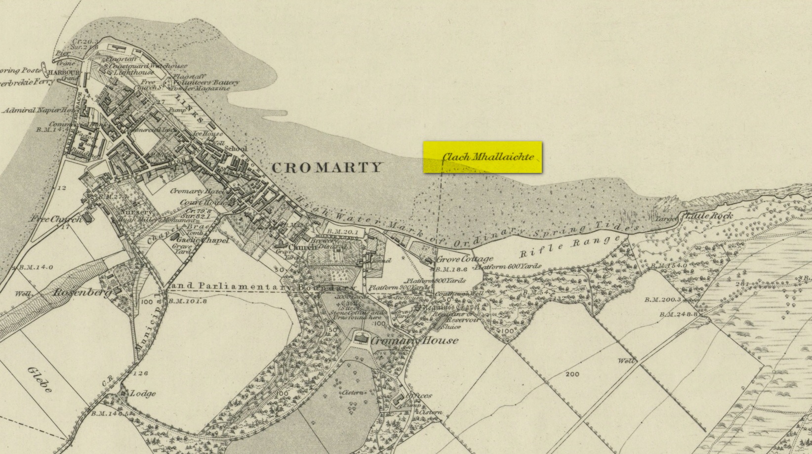
This large boulder found off the Cromarty coast, was highlighted on the 1880 OS-map of the region. It is one of the ancient boundary stones of the township.
Folklore
We know from the vast array on the folklore of stones that many were imbued with magickal abilities, some of which were witnesses to vows and others to make curses from. This large boulder off the coast of Cromarty was, according to Donald MacKenzie (1935), a place where the latter used to be done. He told us:
“At Cromarty there is a big boulder known as the Clach na Mallachd (‘Stone of Cursing’). Curses were delivered when an individual stood or knelt bare-kneed upon it.”
In an earlier account by the Ordnance Survey lads in one of their Name Books, they gave the following tale that had been narrated to them:
“A large stone Situate at the Low Water, and forming one of the boundary Stones of the burgh, the reason of its having this name is, that a young lad while Sitting on it was overwhelmed by the advancing tide and drowned, his mother when told of it, cursed the stone, hence the name Clach Mallach (Accursed Stone)”
References:
MacKenzie, Donald A., Scottish Folk-lore and Folk Life, Blackie: Glasgow 1935.
An old church dedicated to St Bennet once existed on the hill above where this spring of water emerges, but little is now left of the building. Thankfully the holy well hasn’t quite followed in the footsteps of the church. Miss Riley (1935) told us that it can be found “near the high-water mark…situated at the foot of a beautiful little glen which runs inland from the coast” – and from all accounts it is still there.
Shown on the 1880 OS-map of the region, the dedication to St Bennet is obscure. Mr Pullan (1927) suggested it derived from the 6th century St Benedict of Nursia, but this is improbable. The Royal Commission lads thought it more likely derived from “a Celtic foundation.”
Folklore
The earliest description I’ve found regarding the traditions surrounding this well are by Hugh Miller (1835). He wrote:
“It is not yet twenty years since a thorn-bush, which formed a little canopy over the spring of St. Bennet, used to be covered anew every season with little pieces of rag, left on it as offerings to the saint, by sick people who came to drink of the water.”
But the tradition didn’t die out, as evidenced by a short article by Miss M.D. Riley (1935) in Antiquity journal where she gave us further valuable information about its folk history, saying:
“In order to insure the fulfilment of the wish it is essential that the wisher should drink the water and leave something of his personal attire. When the writer visited the spot there was a heterogeneous collection of ‘rags’ hanging on the branches.
“Mr Francis Scott tells me that the site is locally supposed to be the place of judgement. It is close to the ruins of St Bennet’s Chapel and the ground is said to be cursed as it was stoeln by the Church. Even at the present day the owner has to provide each year at Christmas-tide 8 cwt of oatmeal free for the poor of the parish. This has been operative since 1630 and though the owner has tested the matter in the highest court of law in Scotland, his appeal was not allowed.”
The tradition of giving offerings to the spirit of this well was still recorded in 1966.
References:
Hiley, M.D., “Rag-Wells,” in Antiquity, volume 9:4, December 1935.
Legendary Rock (destroyed): OS Grid Reference – NH 792 651
Archaeology & History
In the ruins St Bennet’s Chapel, along with his accompanying holy well (NH 7923 6502), could once be seen a curiously shaped rock which, according to tradition has been destroyed. In Mr Innes’ (1855) major history work he mentioned this Fairies Cradle in passing. Not far from here and close to the coast, is a curiously-shaped boulder with several natural cupmarks (at NH 9150 6497).
Folklore
In Hugh Miller’s (1878) definitive local history work, Scenes and Legends, we have our main description of this once important site. It existed,
“near the chapel itself, which was perched like an eyry on a steep solitary ridge that overlooks the Moray Firth, there was a stone trough, famous, about eighty years before, for virtues derived also from the saint, like those of the well. For if a child was carried away by the fairies, and some mischievous unthriving imp left in its place, the parents had only to lay the changeling in this trough, and, by some invisible process, their child would be immediately restored to them. It was termed the fairies’ cradle; and was destroyed shortly before the rebellion of 1745, by Mr. Gordon, the minister of the parish, and two of his elders.”
The story of children here being carried away by littlepeople and then restored by an impish offering, is a play on the site being a healing stone. There are numerous other “curing stones” found elsewhere in Scotland, but with their own respective traditions—like the Measles Stone at Fearnan, the Whooping Cough Stone near Killin, and many others.
If anyone knows anything more about this lost “curing stone”, please let us know.
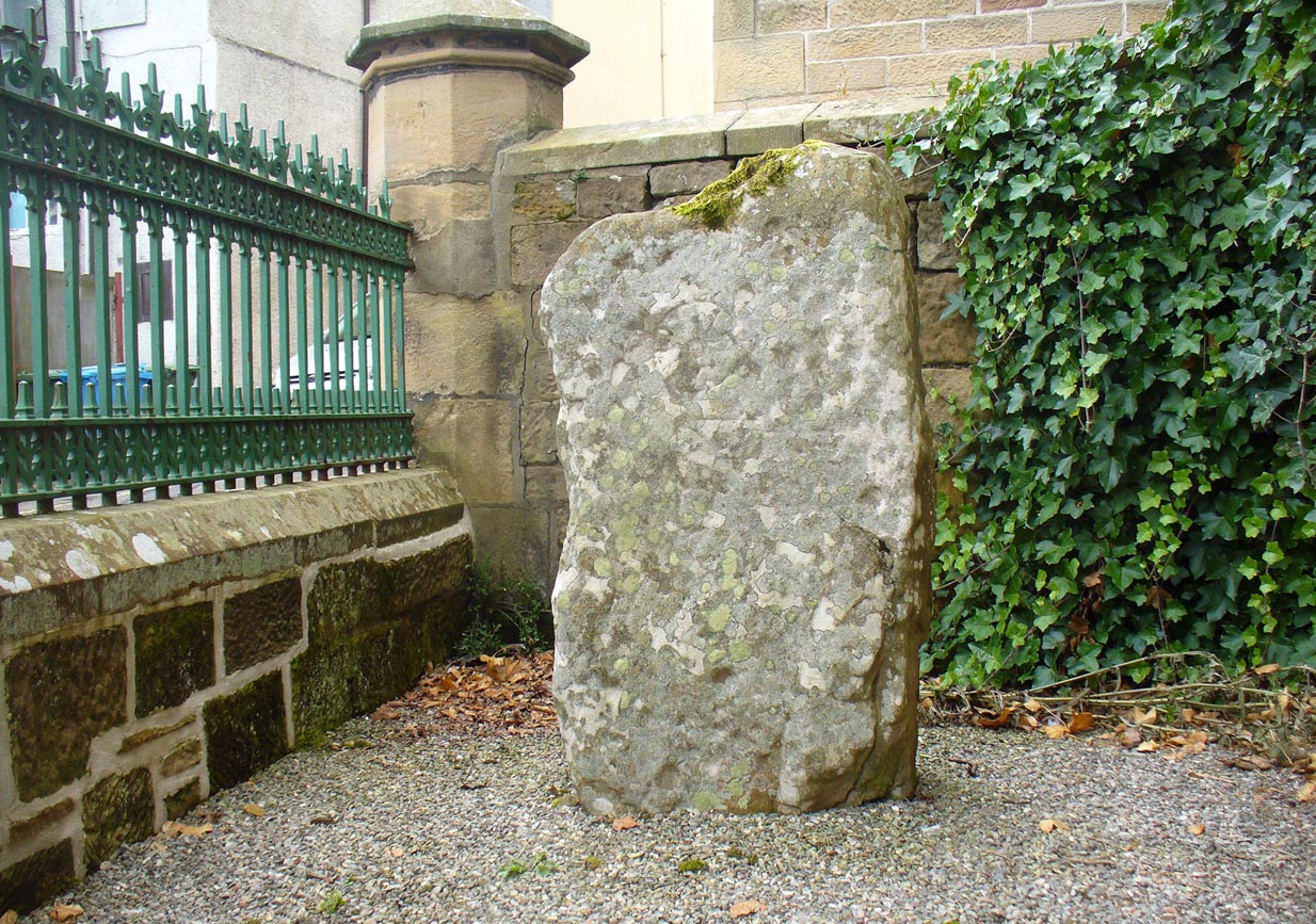
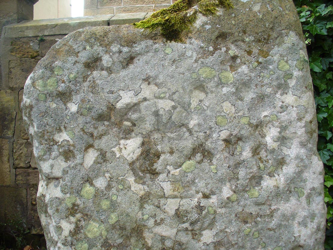
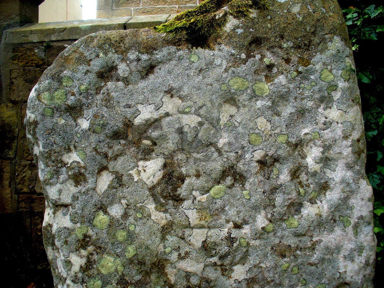
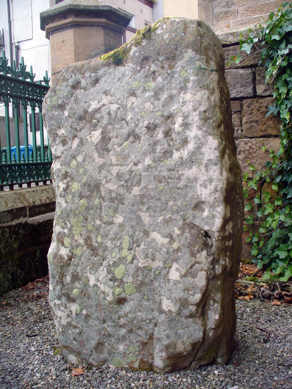
The stone is no longer in its original position (a few miles away), but can now be found if you visit the Tain & District Museum, just off Tower Street, in towards St Duthus’ Church. The stone is upright around the side of the adjacent buildings. It’s probably easier to access if you walk down Castle Brae, keeping your eyes peeled to your left. Otherwise, just ask the helpful people at the Museum and they’ll point you to the spot.
Archaeology & History
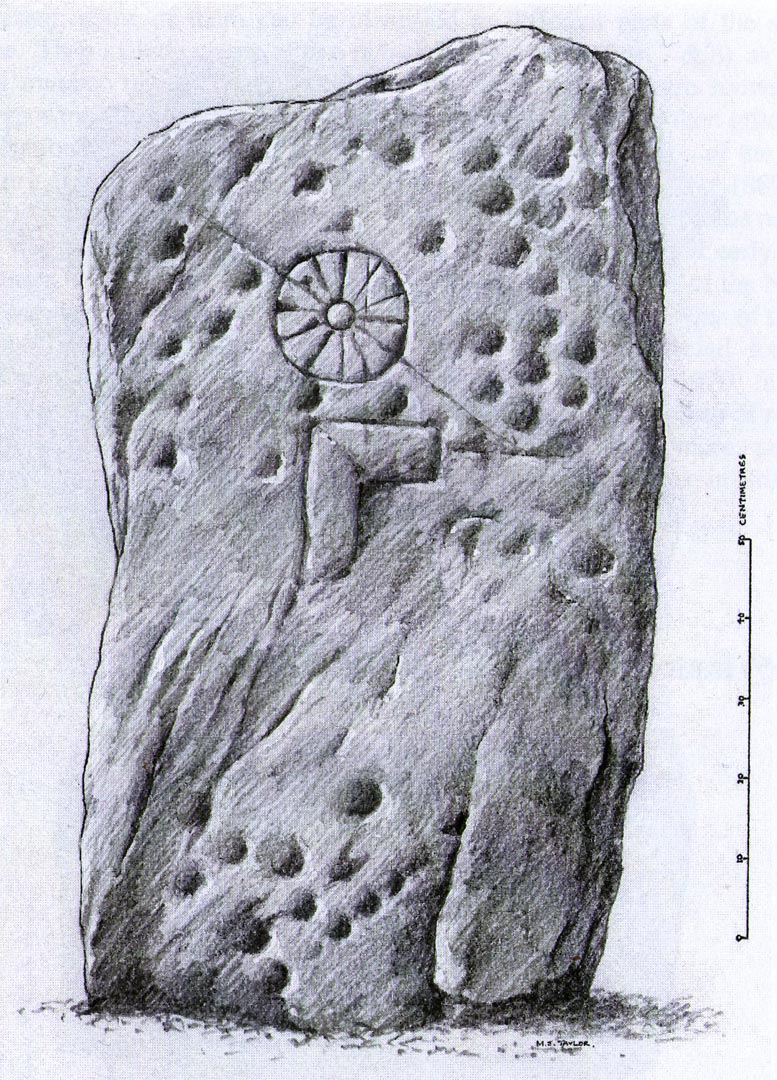
An intriguing stone with what may be a long and fascinating history behind it… It was only rediscovered in the 1960s, when the farmer at Ardjachie (2½ miles northwest of Tain town centre) came across it in one of his fields. It’s not large or notable in any way, other than it possessing a couple of really peculiar symbols etched amongst a mass of otherwise standard neolithic and Bronze Age cup-marks. These other symbols are (as seen in Mark Taylor’s drawing, right) a very distinct ‘spoked wheel’ and what looks like a right-angled ‘tool’ or set-square of some sort. These symbols have brought with them notions from academics who are claim it has Pictish provenance. However, we must be very cautious of this idea….
The first written account of the stone was by Ellis Macnamara (1971) who gave a detailed description of the carving:
Ardjachie Carving (after Mark Taylor 2004)
“Boulder found on Ardjachie Farm, now in Tain Museum. The boulder, of probably local old red sandstone, is uncut and very irregular in shape but has two principal faces; the maximum length is 1.7m; maximum width is 0.65m and on the maximum thickness is some 0.35m. The carvings are all on one face, which is much weathered; the opposing face is conspicuously less smooth so that it is possible that this stone was never set upright. The weathered face is covered with at least 30 ill-defined cup markings scattered over nearly the whole surface, though grouped towards one end; the average diameter of these cup markings is about 3 to 4cm, depth about 1.5cm. There are several indistinct lines among the cup markings and there is among the thickest cluster of cup markings a symbol like a ‘wheel’, with the outer ‘rim’ drawn as a fairly perfect circle, with a diameter at the outer edge of some 17cm. The ‘wheel’ has twelve ‘spokes’ and a single inner circle, or ‘hub’, with a diameter at the outer edges of about 4 or 5cm.”
Subsequent to Macnamara’s description, it’s been suggested that there are cup markings on both sides of the stone; but the ones on the other side are a little less certain. The stone itself almost typifies the cup-marked cist covers we find scattered all over the country—yet no burial or other structure was noted upon its discovery in the fields. It’s an oddity on various levels…
Close-up of spoked-wheelClose-up of spoked-wheel
The spoked-wheel symbol and, moreso, the right-angled element, have led some to speculate that the symbol was carved in Pictish times; but there are problems with this on two levels at least. The cup-marks we know are neolithic or Bronze Age in origin, and their design always inclines to abstract non-linear forms, screwing egocentric analysis. But the ‘spoked wheel’ is more linear in nature. But as acclaimed petroglyph researchers from George Coffey (1912) to Martin Brennan (1983) show, this spoked wheel occurs in neolithic Ireland; and the identical symbol occurs in prehistoric carvings at Petit Mont in France (Twohig 1981), at Cairnbaan in Argyll (Royal Commission 2008) and there’s even a partial spoked-ring on the Badger Stone on Ilkley Moor! We have no need to jump into Pictish times to account for its origin and unless we have direct archaeological evidence to prove this, the academic Pictish association must be treated with a pinch of salt. It is nevertheless scarce amongst neolithic and Bronze Age carvings in Britain. Maarten van Hoek (1990) suggested it to be a variant on the ‘rosette’ design, also neolithic in origin. On the whole the symbol is interpreted as being the sun—which it may well be.
If you look carefully at the images above you can see, to the right of the ‘wheel’, a cup-marking surrounded by a ring of six-cups. It is possible that this may be an older variant of the spiked-wheel solar symbol. All speculation of course. The other peculiar element here is the curious right-angled design, below the ‘sun’. This symbol in particular is quite different from the early cup-marks and may have been carved at a much later date. In which case, this raises the potential for a continuity of tradition here… which mightjust bring in the Picts!
A bittova closer look
But the general problem with a Pictish assignment is that of the Picts themselves. If we ascribe the current anglocentric belief that the Picts only existed between the 3rd and 9th centuries (because we only have written records of them during that period), we are assuming the rather naive philosophy that anything before written history did not exist: a sort of blind-man’s Schrodinger’s Cat ideology, only really accepted by pseudo-historians. But if the Picts didhave something to do with this carving, we may indeed be talking about a continuity of tradition from the ancient past into the written period. Such an idea would be no problem in developed tribal cultures with an animistic cosmology—and that’s assuming that this stone was deemed as ‘special’ in some form or another to the local people. But all these are uncertainty principles in themselves and we may never know for sure…
There are no adjacent monuments to where Ardjachie’s stone came from, and apart from a scatter of flints found a hundred yards or so closer to the beach, other archaeological remains are down to a minimal. Its isolation is peculiar. There are however, a number of springs of water a few hundred yards away, just across the main A9 road, two of which have left their old names with us as the Cambuscurrie Well and the Fuaran nan Slainte, or fountain/spring of Healing (the modern Glenmorangie whisky gets it waters hereby!). Although we must be careful not to assign every example of prehistoric rock art with the same material, the mythic association between petroglyphs and water cannot be understated, and although such an association at Ardjachie is conjectural, it cannot go unnoticed.
References:
Brennan, Martin, The Stars and the Stones: Ancient Art and Astronomy in Ireland, Thames & Hudson: London 1983.
Coffey, George, New Grange and other Incised Tumuli in Ireland, Hodges Figgis: Dublin 1912.
McHardy, Stuart, A New History of the Picts, Luath: Edinburgh 2012.
Mack, Alastair, Symbols and Pictures: The Pictish Legacy in Stone, Pinkfoot Press: Brechin 2007.
Macnamara, Ellen, “Tain, Ardjachie Farm: Cup Markings and Incised Symbol”, inDiscovery & Excavation Scotland, 1971.
From Shieldaig, take the A896 road east to Torridon and Kinlochewe (a bloody superb part of Scotland – perhaps the best!) for a couple of miles, round the stunning bay of Ob Mheallaidh, till you reach the tiny hamlet of Balgie. From here, walk upstream following the small River Balgie until you hit Loch Damh. At the edge of the rugged and boggy flatland shortly before the loch itself, amble about in the rushes on your right (west). You’ll find it!
Archaeology & History
This is a small but chunky standing stone was rediscovered by Dr J. Havelock Fidler in the 1980s. Less than four-feet tall, it stands alone at the edge of the boggy landscape, with superb views all around (the hill in the background photo is An Ruadh-mheallan). There are other human remains scattered amidst the rocky landscape close by, including the remains of old buildings not far away, but this prehistoric monolith seems to be an isolated example. However, the landscape here is so vast that it’s highly likely that other standing stones remain hidden in these ancient mythic hills…
References:
Fidler, J. Havelock, Earth Energies, Aquarian: Wellingborough 1988.
Pretty easy to get to. Go south through the village for a half-mile until you reach the hall by the fire station, sat back on the left-hadn side of the road a few hundred yards past Loch a’ Mhuillinn. Stop here and walk up the slope behind the hall for a hundred yards or so. Walk about!
Archaeology & History
The OS-coordinate here is a loose one. It centres on the notable hillock of Torr Mor, around which are a number of hut circles (at NG 7097 4293; NG 7139 4303; NG 7087 4309; NG 7088 4310 and NG 7090 4320) which are each in a relatively good condition and are thought to date from at least the Iron Age. When I visited them, the bracken had encroached on all but one of them (the last in the list above), which was about 30 feet across.
North of here are several curious-looking heaps of stones which need closer examination when the vegetation has died away. At first glance they would seem to be cairns, i.e. tombs. No such prehistoric graveyard has been found anywhere on the peninsula as yet – but considering the existence of the settlements in the area at Sand, you’d think there’d be one somewhere!
The Cambridge biologist J. Havelock Fidler described finding three standing stones in the gorgeous little remote hamlet of Toscaig in his book Ley Lines (1983), which neither the Applecross Local History Society, myself, nor anyone else has been able to locate (the OS grid reference cited above is simply an approximation of their locality). In an updated version of his work, Mr Fidler seems to indicate they can be found a short distance south-east of the village, at the end of an alignment which is supposed to start at Fearnmore (NG 724 605), at the northern edge of the peninsula. If they exist, could anyone perhaps enlighten us as to their whereabouts…?
References:
Fidler, J. Havelock, Ley Lines – Their Nature and Property, Aquarian: Wellingborough 1983.
We were up here again in July 2009, but I’ve still not been across onto the island itself — just stared from the lochside, dying to swim across and spend a night or three alone on the island amidst this legendary landscape. Basically, get to Talladale on the A832 (halfway between Gairloch and Kinlochewe), then walk up to the loch-side to your right (east) for a mile till you reach the small wooded outcrop. Look north, betwixt the two isles and its the one in the middle with the Crag of the Bull and Maire’s Cairn rising up the mountain face behind. But you can reach it via a boat trip from one of the local harbours. Staying there overnight however, would seem more troublesome. It seems that a winter visit seems best!
Folklore
This ‘holy well’ has a prodigious occult history which, sez my nose, is still maintained by one or two old Highland folk up here. This small island (one of many in this long loch) was the Isle of the Druids in old days: legend telling it to be the teaching ground of these shady priests. Even the Iona druids came here. The main relics on on the island are the old holy well, accompanied by an old legendary tree into which all local people flocked and wedged coins at least once in their life. This devotional rite eventually took its toll, with so many of the coins covering the old tree with metallic scales to a height of nine feet, eventually killing it.
The well itself was said to cure insanity — no doubt the remedial quality given to the waters after neophyte druids had spent many days of ritual solitude here, eventually sipping its life-giving fluid to revive them from their ordeal.
It eventually became sanctified by the Church: legend saying it was St. Maelrubha (the same dood who turned the healthy Applecross heathens into church-goers) who was the guilty party. Indeed, the name Maree itself, was proclaimed as deriving from this old saint, though local lore tells it to derive from the pagan ‘ane god Mourie.’
Elizabeth Sutherland (1985) reported that remains of the sacred tree were still visible. It is also said that no-one makes ritual commemmoration here anymore. Hmmmm… don’t always believe what you read.
In the 18th century, when Thomas Pennant visited this sacred well, he described that,
“in the midst is a circular dike of stones… I expect the dike to have originally been druidical, and that the ancient superstition of paganism had been taken up by the saint (Maelrubha) as the readiest method of making a conquest over the minds of the inhabitants.”
References:
Dixon, John, Gairloch in North-west Ross-Shire, Co-op: Edinburgh 1886.
MacKenzie, Kenneth C., Loch Maree: The Jewel in the Crown, privately printed 2002.
MacKinlay, James M., Folklore of Scottish Lochs and Springs, William Hodge: Glasgow 1893.
Pennant, Thomas, A Tour in Scotland and Voyage to the Hebrides, MDCCLXXII, John Monk: Chester 1774.
Polson, Alexander, Gairloch, George Souter: Dingwall 1920.
Sutherland, Elizabeth, Ravens and Black Rain, Constable: London 1985.
Watson, W.J., Place-Names of Ross and Cromarty, Northern Counties Printing: Inverness 1904.
* This beautiful painting is one of many done by local artist, Bryan Islip. It is taken from his 2010 Calendar, Scotland’s Wester Ross, and is available direct from him. If you’d like to know more, or want copies of his calendar or other artworks, email him at: pico555@btopenworld.com – or check his website at www.picturesandpoems.co.uk