Two Eggs, Morton Moor, West Yorkshire

Legendary Rocks:  OS Grid Reference – SE 1058 4490

Getting Here

Two Eggs on 1851 map

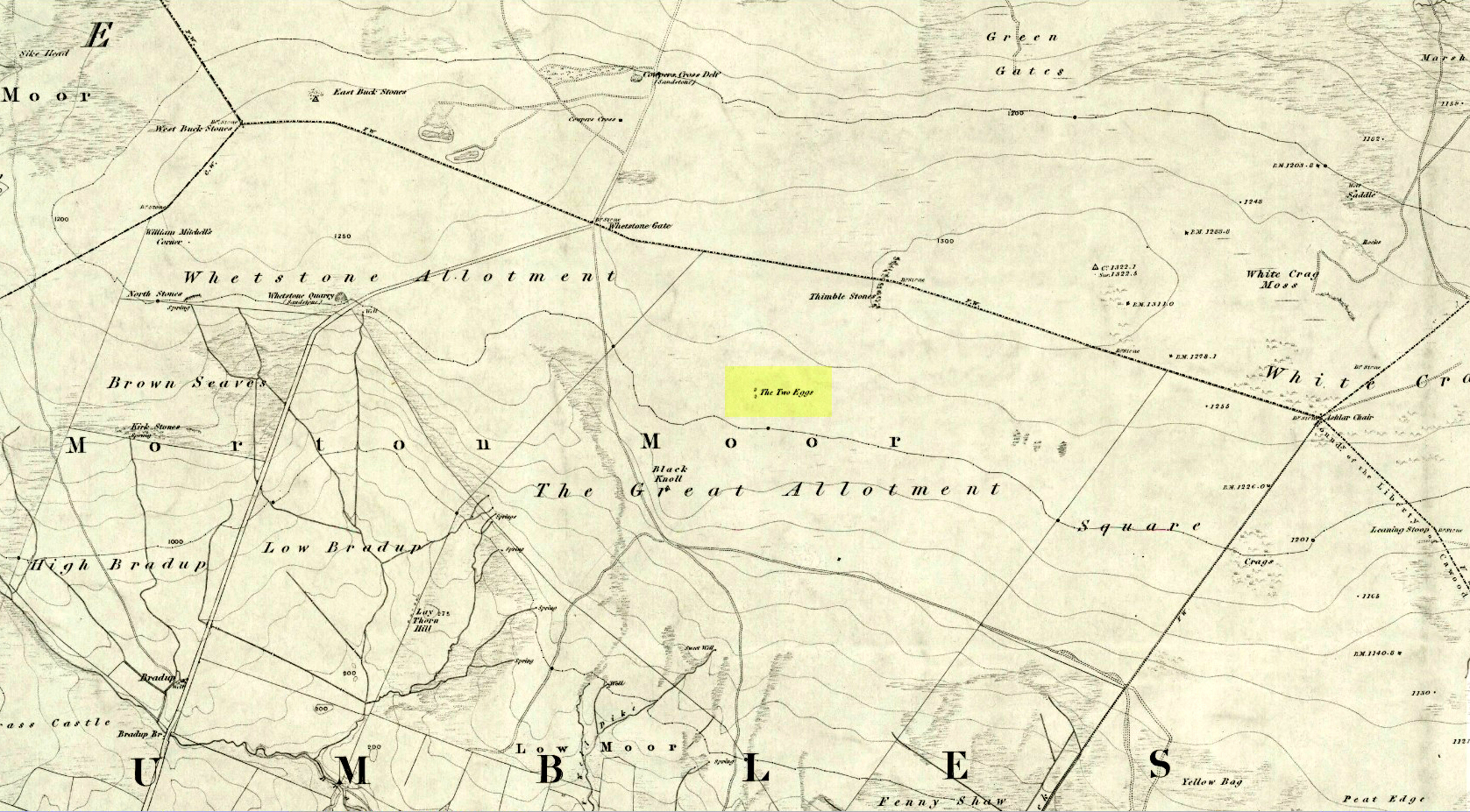
By whichever route you wanna take, get y’self to the prominent cup-and-ring marked rocks known as the Thimble Stones near the very top of these moors. From here, walk roughly 400 yards southwest onto the bare open moors (there are no footpaths here) and you’ll see these two isolated prominent boulders living quietly on their own.  You can’t really miss ’em!  You’re there.

Archaeology & History

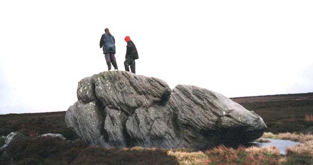
Of the two giant boulders here, both are included in the petroglyph surveys of Hedges (1986) and Boughey & Vickerman’s (2003) as possessing “all natural” cup-marks on their top and vertical surfaces.  Those on top of the rocks certainly seem to be Nature’s handiwork, whilst many of the seeming ‘cups’ on the vertical face of one (not the one pictured here) are due to gunshots.  I’m not quite sure when they were done, but they certainly didn’t exist during the many visits I made here in the in the 1970s and ’80s.

They stones included in most of the standard antiquarian surveys of the 19th century, with the earliest being Forrest & Grainge (1869) who described them as,

“two detached masses of rock, standing alone upon the moor.  The first is 14ft in length by 8ft in height, tapering to the ground; a set of cups and channels occupy the highest point.  The other, distant 13 yards, is of an irregular square form, 45 yards in circumference and 7ft high.  This stone appears to be tilted on its edge, presenting its cleavage upwards, and has hollows containing water, but is so much wasted above that if it has ever borne the cups and channels, they are now obliterated.”

On top of an Egg, c.1986

Collyer & Turner (1885) described “a number of cups” on the edge of the northern rock; and Romilly Allen (1896) likewise.  Even that historical literary giant, Harry Speight (1900), added his own tuppence here, telling folks how both Eggs “are channelled and bear cups.”

It’s very possible that these isolated stones did have some sort of significance to our prehistoric ancestors.  There are innumerable examples worldwide of rocks like this possessing ritual and mythic lore—and many in the British Isles too.  And the cupmarks on the stones may have been enhanced by those same prehistoric ancestors.  But we’ll never know for sure…

Folklore

The creation myth behind the Two Eggs is one echoed in traditions across the world.  Folklore tells that the Eggs were said to have been laid here by a great dragon who lived within a hill some distance to the south.  All other aspects of the tale have sadly long since been forgotten…

References:

  1. Allen, J. Romilly, “Cup and Ring Sculptures on Ilkley Moor,” in The Reliquary, volume 2, 1896.
  2. Bennett, Paul, The Old Stones of Elmet, Capall Bann: Milverton 2001.
  3. Boughey, Keith & Vickerman, E.A., Prehistoric Rock Art of the West Riding, WYAS: Wakefield 2003.
  4. Collyer, Robert & Turner, J.H., Ilkley: Ancient and Modern, William Walker: Otley 1885.
  5. Forrest, Charles & Grainge, William, A Ramble on Rombald’s Moor, Northern Antiquarian: Bradford 2012 (1st published 1867-69).
  6. Hedges, John (ed.), The Carved Rocks on Rombalds Moor, WYMCC: Wakefield 1986.
  7. Speight, Harry, Upper Wharfedale, Elliott Stock: London 1900.

© Paul BennettThe Northern Antiquarian


St. Michael’s Well, Edinburgh, Midlothian

Holy Well (destroyed):  OS Grid Reference – NT 2618 7353

Also Known as:

  1. Canmore ID 75958
  2. Silver Well

Archaeology & History

Reproduction 1540 sketch showing the Well

This ‘holy well of the dragon-slayer’ could once be found close to where old Cowgate meets St Mary’s Street.  Highlighted on an old map of the city around 1540, and on Mr Bryce’s sketch of the old inner city at the end of the 19th century, we do not know when the Well acquired its name, but it may have been by an early group of jews, to whom the saint was important.   Hereby in 1779 was listed a small piece of land called the ‘Silverwell Close’ which both Watson (1923) and Harris (1996) thought was a corruption of the St Michael’s Well, somehow.  Watson (1923) explained that St Michael’s

“connection with fountains, or a ‘silver well’, is probably due to the legends of the miraculous spring of Monte Galgano in Apulia and Mont-Saint-Michele in Normandy.”

In Ruth & Frank Morris’ (1981) survey of Scottish holy wells, they report how, in the 16th century, this forgotten site was “a favourite resort” of local people.  They told how,

“in 1543 an act of penance was ordered to be performed at the fountain of St. Michael.”

St Michael was a powerful mythic figure to the Muslims, Christians and Jews.  In the old calendar in Scotland his festival date was September 29th and known as ‘Michaelmas’ (although other dates have been ascribed by the varying sects in other countries).  In truth, this site should be highlighted for tourists, pilgrims, historians and religious followers alike due to the importance this mythic figure once held in the various pantheons.

References:

  1. Bennett, Paul, Ancient and Holy Wells of Edinburgh, TNA 2017.
  2. Harris, Stuart, The Place-Names of Edinburgh: Their Origins and History, Gordon Wright: Edinburgh 1996.
  3. Morris, Ruth & Frank, Scottish Healing Wells, Alethea: Sandy 1982.
  4. Watson, Charles B.B., “Notes on the Names of the Closes and Wynds of Old Edinburgh,”in Book of the Old Edinburgh Club, volume 12, 1923.

© Paul Bennett, The Northern Antiquarian 


St. George’s Well, Edinburgh, Midlothian

Holy Well:  OS Grid Reference – NT 24401 74070

Also Known as:

  1. Canmore ID 133173

Getting Here

St George's Well on 1851 map
St George’s Well on 1851 map

In Edinburgh, get to the west-end of Princes Street (nearest the castle), and where there’s the curious mess of 6 roads nearly skewing into each other, head down Queensferry Street for 450 yards until, just before you go over the bridge, walk down Bells Brae on your left, then turn right down Miller Row where you’ll see the sign to St. Bernard’s Well.  St. George’s Well is the small, dilapidated spray-painted building right at the water’s edge 200 yards before St. Bernard’s site.

Archaeology & History

Compared to its companion holy well 200 yards downstream, poor old St. George’s Well is a paltry by comparison, in both historical and literary senses.  The site was said to have been “set up in competition with St Bernard’s Well but never achieving its purpose”, wrote Ruth & Frank Morris (1982)—which is more than a little sad.  Not on the fact that it failed, but on the fact that some halfwits were using local people’s water supply to make money out of and, when failing, locked up the medicinal spring and deny access to people to this day!

In Mr Grant’s Old & New Edinburgh (1882), the following short narrative was given of the site:

“A plain little circular building was erected in 1810 over (this) spring that existed a little to the westwards of St. Bernard’s, by Mr MacDonald of Stockbridge, who named it St. George Well.  The water is said to be the same as the former, but if so, no use has been made of it for many years…”

St George's Well, looking N
St George’s Well, looking N
St George's Well, looking SW
St George’s Well, looking SW

The association to St. George was in fact to commemorate the jubilee of King George III that year.  If you visit the place, the run-down little building with its grafitti-door has a small stone engraving etched above it with the date ‘1810’ carved.

As the waters here were found to possess mainly iron, then smaller quantities of sulphur, magnesia and salts, it was designated as a chalybeate well.  Its curative properties would be very similar to that of St. Bernard’s Well, which were very good at,

“assisting digestion in the stomach and first passages … cleansing the glandular system, and carrying their noxious contents by their respective emunctories out of the habit, without pain or fatigue; on the contrary, the patient feels himself lightsome and cheerful, and by degrees an increase to his general health, strength and spirits.  The waters of St. Bernard’s Well operates for the most part as a strong diuretic.  If drunk in a large quantity it becomes gently laxative, and powerfully promotes insensible perspiration.  It likewise has a wonderfully exhilarating influence on the faculties of the mind.”

References:

  1. Bennett, Paul, Ancient and Holy Wells of Edinburgh, TNA: Alva 2017.
  2. Grant, James, Cassell’s Old and New Edinburgh – volume 3, Cassell, Petter Galpin: London 1882.
  3. Harris, Stuart, The Place-Names of Edinburgh, Gordon Wright: Edinburgh 1996.
  4. Hill, Cumberland, Historic Memorials and Reminiscences of Stockbridge, the Dean and Water of Leith, Robert Somerville: Edinburgh 1887.
  5. MacKinlay, James M., Folklore of Scottish Lochs and Springs, William Hodge: Glasgow 1893.
  6. Morris, Ruth & Frank, Scottish Healing Wells, Alethea: Sandy 1982.
  7. Royal Commission on the Ancient & Historical Monuments, Scotland, Inventory of the Ancient & Historical Monuments of the City of Edinburgh, HMSO: Edinburgh 1951.

© Paul Bennett, The Northern Antiquarian 


Dragon Stone, Steeton, West Yorkshire

Cup-and-Ring Stone:  OS Grid Reference – SE 03590 43677

Also Known as:

  1. Hollins Bank Farm Carving

Getting Here

Dragon Stone carving

Go northwest along the country lane running between High Utley (on the outskirts of Keighley) and Steeton known as Hollins Lane, which then becomes Hollins Bank Lane.  You’ll see the fine castle building as you go along, known simply as The Tower arising from the top of the tree-line.  As you get to the driveway leading down to the Tower, a less impressive farm building is on the other side of the road, known as Hollins Bank Farm.  On the right-hand side of this house is an old overgrown road.  Walk along here to the end, going into the field immediately left where a small group of stones can be seen halfway up the field by the tree.  You’re here!

Archaeology & History

First discovered one sunny afternoon on April 7, 2010, in the company of Buddhist scholar Steve Hart, this is a really curious carving, inasmuch as it seems to have been deliberately carved around what may be curious naturally eroded cup-forms.  You’ll have to visit it to see what I mean.  They’re a bit odd.  Almost too perfect as cups to be the ancient eroded ones we’re used to looking at.  But this aside….

…and again
Dragon Stone, looking NW

It’s a lovely flat stone, with curvaceous lines running across the middle and edges and into cup-markings.  Although some of the cups give an impression of being natural, others have the authentic-looking ring to them, with at least one of them possessing a near-complete ring encircling it (as you can faintly see in the close-up photo here).  There are at least 19 cup-markings on this stone, and four main ‘lines’ running roughly in north-south directions, with the cups interspersed between them.  At the top (north) end of the rock, separated by a crack, the lines stop and we just have some cup-markings.  The crack in the stone may have been functional here.

Although graphically different, the carving has a similar feel in design (for me at least) to that of the Wondjina Stone at Rivock Edge, on the other side of the Aire Valley a couple of miles east of here — though this newly found carving is in a better state of preservation.  The small scatter of rocks around it seem to have been unearthed or moved recently by the land-owner (who aint keen on you looking on his land, so be careful) and the good state of preservation may be that they were only unearthed sometime this century.  We must also keep in consideration that the lines that run across the surface of this stone are water-lines and may be more the result of Nature’s hand than humans.  It’s obvious that some human intervention has occurred here, but it may be difficult to ascertain the precise degree of affectation between the two agencies.

Close-up of cups & lines

According to the archaeological record-books there are no carvings here, but another simple cup-marked stone accompanies this more extravagant serpentine design just a few yards away; a simple cup-marked stone may be seen at the top of the hill; and the faint Currer Woods carving can be found 0.68 miles (1.09km) due west of here, on the other side of the small valley.  Other outcrop stones scatter the fields and slopes here, some of which still need checking to see whether or not further carvings exist.

…And for those who may bemoan my seemingly romantic title of the carving: remember! — close by in Steeton township, between the years 1562 and 1797, there was an old field-name known well to local folk, of “one parcel of arable land in town field called Drakesyke, 3 acres”, i.e., the dragon’s stream or dyke. (Gelling 1988; Smith 1956)

References:

  1. Clough, John, History of Steeton, S. Billows: Keighley 1886.
  2. Gelling, Margaret, Signposts to the Past, Phillimore: Chichester 1988.
  3. Smith, A.H., English Place-Names Elements – 2 volumes, Cambridge University Press 1956.

© Paul Bennett, The Northern Antiquarian


St. Michael’s Well, Well, North Yorkshire

Holy Well:  OS Grid Reference – SE 2633 8176

Also Known as:

  1. Mickel Well
  2. Mickey Well

Getting Here

Found near the bottom of Holly Hill, as Graeme Chappell tells us, this old site “is located by the side of a narrow lane on the west side of the village of Well (aptly named). The OS map places the well on the north side of the lane, but this is only the outflow from a pipe that carries the water under the road.  The spring actually rises at the foot of a small rock outcrop, on the opposite side of the road.”

Archaeology & History

St. Michael's Well, Well (Bogg 1895)
St. Michael’s Well, Well (Bogg 1895)

Although the village of Well is mentioned in Domesday in 1086 and the origin of the place-name derives from “certain springs in the township now known as The Springs, St. Michael’s Well and Whitwell,” very little appears to have been written about this place.  Edmund Bogg (c.1895) wrote that an old iron cup — still there in the 19th century — was attached next to this spring for weary travellers or locals to partake of the fine fresh water.  Nearby there was once an old Roman bath-house and, at the local church, one writer thinks that the appearance of “a fish-bodied female figure…carved into one of the external window lintels” is representative of the goddess of these waters.  Not so sure misself — but I’m willing to be shown otherwise.

Folklore

Around 1895, that old traveller Edmund Bogg once again wrote how the villagers at Well village called this site the Mickey or Mickel Well,* explaining: “the Saxons dwelling at this spot reverently dedicated this spring of water to St. Michael.” A dragon-slayer no less!

Although not realising the Michael/dragon connection, the same writer later goes on to write:

“There is a dim tradition still existing in this village of an enormous dragon having once had its lair in the vicinity of Well, and was a source of terror to the inhabitants, until a champion was found in an ancestor of the Latimers, who went boldly forth like a true knight of olden times, and after a long and terrible fight he slew the monster, hence a dragon on the coat of arms of this family. The scene of the conflict is still pointed out, and is midway between Tanfield and Well.”

This fable occurred very close to the gigantic Thornborough Henges!  It would be sensible to look more closely at the mythic nature of this complex with this legend in mind.  A few miles away in the village of Kirklington, the cult of St. Michael could also be found.

References:

  1. Bogg, Edmund, From Eden Vale to the Plains of York, James Miles: Leeds n.d. (c.1895)
  2. Smith, A.H., The Place-Names of the North Riding of Yorkshire, Cambridge University Press 1928.

* In old english the word ‘micel‘ (which usually accounts for this word) means big or great. On the same issue, the ‘Holly Hill’ in the case here at Well actually derives from the holly tree and NOT a ‘holy’ well. However, check the folklore of this tree in Britain and you find a whole host of heathen stuff.

© Paul Bennett, The Northern Antiquarian


Worm Well, Fatfield, Durham

Sacred Well: OS Grid Reference – NZ 3115 5401

Getting Here

This seems a bittova cheat really – and on two counts: i) I aint been here yet; and ii) we’re not sure that there’s any remains left to be seen.  But these notes might produce a result, so direction pointers are worthwhile I reckon!  Various ways to come, but you need to end up on the weird-sounding Bonemill Lane – whether you get there via Worm Hill Terrace or Biddick Lane aint important.  Once on the right road, you wanna stand by the supposedly haunted Biddick Inn, and walk down the road a short distance until you reach a path on your right which heads up towards the ruined Worm Hill.  Halfway along here – or thereaboots – the old Worm Well could once be seen.

Archaeology & History

This was initially very difficult to pin down with any certainty, though after a few hours investigation, Keighley archives researcher Michala Potts found it highlighted on a field-map of the region from 1750, as the illustration here clearly shows.

Map highlighting the Worm Well, 1750
Map highlighting Worm Well, 1750

During its “missing years”, several accounts describe the well as being between Worm Hill and the River Wear, which is what’s clearly shown here.  So the possible confusion there may have been (which I initially had aswell) between the riverside spring opposite the pub and the now missing Quarry Well on the far western side of Worm Hill, can at least been dispelled.   The position of the site was described by the holy wells writer, Alan Cleaver [1985], who told that “the well still exists, having been restored in 1974, at the foot of Worm Hill at Penshaw on the north bank of the river.”  Local history records tell that a plaque commemorating the site was put here the same year; and this note is again confirmed in Paul Screeton’s [1978] excellent survey of the dragon legends hereabouts.  Records from the mid-18th century tell that the Worm Well possessed “a cover and an iron dish or ladle” (Binnall & Dodds 1943) to protect the waters.

Folklore

We find from old records that in the middle of the 18th century, “it was a wishing well and a place of festivity on Midsummer Eve.”  The common veneration of crooked pins were offered at this legendary site.

…And then, of course, we have the great Legend of the Lambton Worm, whose spirit form gives this site so much importance.  This well-known folk-tale tells that the great serpent emerged from this very water source.  In this renowned creation myth of the landscape, and the sites upon it, we have the dragon, the cailleach, the waters, and more…

In a recent narrative of the Lambton Worm story, author Karen Liebreich (2012) sent us an excerpt from her new book, UneXplained: Spine-tingling tales from Real Places in Great Britain and Ireland, which outlines more of the tale.  Karen writes:

“Simon, the heir to Lambton Castle, was a wild boy who never paid attention to his lessons or his elders. He liked only to play with the local boys from the village and their games were rough and annoyed other people. They went joy-riding with carts and donkeys, they stole apples from the trees, they frightened younger children. They liked to go hunting for rabbits and fishing for eels in the local river. The lord of the manor, Simon’s father, thought his son should behave better since one day he would be in charge. Simon could not be bothered.

“One Sunday, when he should have been in church, Simon played truant with Stephen, his friend, and two other boys from the village, and went fishing in the river Wear.  After hours of dull waiting, chatting and eating their picnic, Simon caught a strange-looking animal. It did not look like the regular eels and small fish they usually caught. It was no longer than his finger, dark green and with two little fins on its back. Its skin was rough and scaly, and it had four short legs, with sharp clawed feet. Its face was repellent, with a long pointed snout, twelve little teeth sharp as pins, and red glowing eyes.

“Stephen peered over Simon’s shoulder at the animal. “Yuk, throw it back,” headvised. But Simon had caught nothing else, and he was intrigued by the little beast. He put it in his pouch. As the boys walked home, kicking stones and chatting, they noticed a foul smell. It came from Simon’s pouch. They were just passing the well by the castle, so Simon tossed the squirming worm in, and promptly forgot all about it….”

Read the rest of the story in on Kindle at – http://amzn.to/SsjKK6

…to be continued…

References:

  1. UneXplained - LiebreichBinnall, P.B.G. & Dodds, M.H., ‘Holy Wells in Northumberland and Durham,’ in Proc. Soc. Antiq. Newcastle-upon-Tyne, 4th series, volume 10:2, January 1943.
  2. Cleaver, Alan, ‘Holy Wells – Wormholes in Reality,’ in Source magazine, no.3, November 1985.
  3. Liebreich, Karen, UneXplained: Spine-tingling tales from Real Places in Great Britain and Ireland, Kindle 2012.
  4. Screeton, Paul, The Lambton Worm and other Northumbrian Dragon Legends, Zodiac House: London 1978.

© Paul Bennett, The Northern Antiquarian


Serpent’s Well, Chipping Norton, Oxfordshire

Sacred Well:  OS Grid Reference – SP 31 27?

Archaeology & History

This legendary-sounding spring of water was described in field-name listings from the 1770 Enclosure Acts, but nothing seems to have been written about it since.  To me at least, there seems little doubt that this site would have been a sacred or legendary water-site. Curiously it is in William Henderson’s collection of northern folk-tales where we find a mention of further dragon lore from the township, albeit briefly, where he wrote:

“Near Chipping Norton, in Oxfordshire, A.D. 1349, was a serpent with two heads, faces like women, and great wings after the manner of a bat.”

In Nigel Pennick’s (1997) overview of dragon legends he copied Henderson’s earlier note, but neither of them gave specific indications relating the legend with our Serpent’s Well.  So, to those of you who live in and around Chipping Norton (where I spent two very good years living with Sir Wilson at the Rollright Stones) – what has become of it?  Where exactly is it?  And does anyone know anything more behind this tale and any further history behind the ‘Serpent’s Well’?

References:

  1. Gelling, Margaret, The Place-Names of Oxfordshire, Cambridge University Press 1953-54.
  2. Henderson, William, Notes on the Folk-lore of the Northern Counties of England and the Borders, Folklore Society: London 1879.
  3. Pennick, Nigel, Dragons of the West, Capall Bann: Chieveley 1997.

© Paul Bennett, The Northern Antiquarian


Dragon Well, Wharncliffe, South Yorkshire

Holy Well:  OS Grid Reference – SK 3054 9609

Also Known as:

  1. Dragon’s Well

Folklore

Dragons Well on 1855 map

Highlighted on the first OS-map of the area in 1855—along with it’s home and an associated site of the Cailleach, or Old Wife’s Cellar close by—the famous Wharncliffe Dragon used to drink from here, moreso than the other Dragon’s Well at Bolsterstone more than a mile to the west.  The dragon – with its “seven heads and twice seven eyes” – lived a short distant away on the rocks above, at the Dragon’s Den.  The description of this great beast and its antics at the well were summed-up in Rob Wilson’s book on the Holy Wells of South Yorkshire (1991). He told that:

“The Wharncliffe area has been taken as the setting for the theme of a centuries-old ballad of 19 stanzas , its full title being, ‘An Excellent Ballad of a Dreadful Combat fought between Moore of Moore-Hall and the Dragon of Wantley.’ The 6th and 13th stanzas contain references to Dragon’s Well and are printed below in full:

“Some say this dragon was a witch;
Some say he was a devil;
For from his nose a smoke arose,
And with it burning snivel;
Which he cast off when he did cough,
Into a well that stands by;
Which made it look just like a brook
Running with burning brandy.

It is not strength that always wins,
For wit doth strength excel;
Which made our cuning champion
Creep down into a well:
Where he did think this dragon would drink,
And so he did in truth;
And as he stopp’d low, he rose and cry’d Boh!
And he hit him on the mouth!””

References:

  1. Jewitt, Llewellyn, ‘The Dragon of Wantley and the Family of Moore,’ in The Reliquary, April 1878.
  2. Wilson, Rob, Holy Wells and Spas of South Yorkshire, Northern Arts: Sheffield 1991.

© Paul Bennett, The Northern Antiquarian


Dragon’s Well, Bolsterstone, South Yorkshire

Holy Well:  OS Grid Reference – SK 2827 9697

Also Known as:

  1. Allman Well

Archaeology & History

Allman or Dragon Well, 1855 map
Allman or Dragon Well on the 1855 map

Also known as the Allman’s Well, an inscription with an 1818 datestone was to be found here. But according to folklorists Dave Clarke & Phil Reeder, the site can no longer be found as its waters were “diverted for use at a nearby farm.” However, something that does need checking is their description of a cup-and-ring stone on one of the boulders close by – reckoned to be one of those dropped by the dragon which gives the well its name.

Folklore

Something strange was once going on in this locality if place-names and legends have owt to go by. The local Wharncliffe Dragon, as it was known, used to fly from its home at the Dragon’s Den (a mile-and-a-half east of here) and drink the waters from this well. On one of its flights from Wharncliffe Crags, it carried with it three huge boulders which it dropped in transit and which were said by the folklorists David Clarke and Phil Reeder “to stand in a line on the slope below the well at Townend Common.”

The water from here was said to be good for curing both asthma and bronchitis and was also said never to have dried up, even in the greatest of droughts.

References:

  1. Wilson, Rob, Holy Wells and Spas of South Yorkshire, Northern Arts: Sheffield 1991.

© Paul Bennett, The Northern Antiquarian