Alresford Hill, Alresford, Essex

Tumulus (destroyed):  OS Grid Reference – TM 0628 2022

Archaeology & History

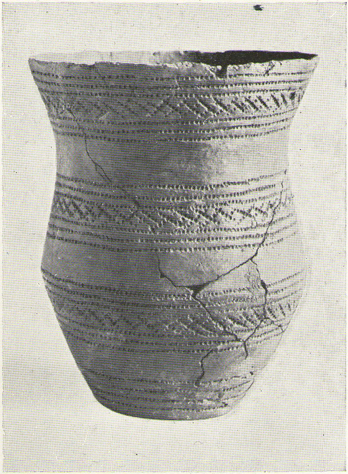
Alresford Hill urn

In a region well known for the finding of early British remains (Belloc 1905), another prehistoric burial mound was destroyed in the Essex landscape simply due to ignorance and neglect.  Thankfully once more we have local antiquarians and an astute schoolgirl for discovering and preserving a record of this site, otherwise we’d have no record of the place at all!  Described in M.R. Hull’s (1946) article on some of the Bronze Age relics of the area, he told how a well-preserved urn in the edge of the tumulus,

“was found in June 1942 by a schoolgirl, Miss Anne Pilkington, on the top of the hill overlooking Alresford Creek and the Colne Estuary, about 70 yards northwest of Bench Mark 74.8 and 560 yards slightly west of south from Alresford church, west of the road to the creek and south of the lane running west along the north side of the field.  This is the northern limit of a huge gravel-pit. She noticed the vessel standing upright in the side of the pit and recovered it. Nothing else was noticed…

“Afterwards the diary of our late Fellow, Mr P.G. Laver came into my hands and I find under the date 8th July, 1922, that he noticed, when motoring past the site, ‘a definite tumulus, but much ploughed down, now barely 18ins above the field level.  It is close to the road through the field, the centre being roughly 20 yards S of the road and about 200 yards from the road to the ford.’ The sketch-plan leaves no doubt on the identity of the site.”

Annoyingly though, Mr Hull didn’t think it worthwhile to reproduce this alleged sketch-map.  He did however give us a good description of the urn and its position in the ground, saying,

“The vessel is stated to have been about 5ft below the surface when found, but I am not certain whether the top-soil had been removed or not.  The clay is fine, burnt light red, but black within, and the whole body is covered with horizontal lines impressed in exactly the same way as (those on the Flag Inn urn), but much less clearly.  The base is slightly hollowed beneath and is not far from having a foot-ring.”

Folklore

Mr Hull (1946) also made an interesting comment on the views of local people about the site where Anne had found this urn, reminding me of what Highland and hill folk would have put down to faerie-lore, though no such memory was noted. He told:

“On enquiry I learnt that no one had observed a mound at the spot, but that it had been observed that exactly there the corn, when the field was cultivated, grew taller and greener in a large round patch”!

References:

  1. Belloc, Hilaire, The Old Road, Archibald Constable: London 1905.
  2. Hull, M.R., “Five Bronze Age Beakers from North-East Essex,” in Antiquaries Journal, volume 26, Jan-April 1946.

© Paul Bennett, The Northern Antiquarian

Flag Inn, St. Osyth, Essex

Tumulus (destroyed):  OS Grid Reference – TM 117 178

Archaeology & History

Bronze Age beaker from the Flag Inn tumulus

Roughly halfway between Thorrington and St. Osyth, a few hundred yards east of the Flag Creek on the grassy wasteland south of the historic Flag Inn, could once be found a fine tumulus, of whose past we sadly know so little.  Nothing now remains of the old burial mound apart from a carved urn that once lived therein and was recovered from the site before its final demise.  According to M.R. Hull (1946) the well-preserved Bronze Age beaker found here—which he said “stood out as different” from others in this area—

“was found in 1930 on the 50ft contour-line about 200 yards south-southeast of the Flag Inn, in a gravel pit, in St. Osyth parish. The position is a mile and a quarter north-northwest of St. Osyth church.  On this occasion it was not possible to examine the site, which could only be established with moderate accuracy some time after the discovery…

“The clay is fine, of light red colour, ornamented with three bands of trellis pattern, each bounded by three horizontal lines, and a band of four such lines at the base, all executed with an instrument making a short line of square impressions, probably the end of a comb used in weaving.”

References:

  1. Hull, M.R., “Five Bronze Age Beakers from North-East Essex,” in Antiquaries Journal, volume 26, Jan-April 1946.

© Paul Bennett, The Northern Antiquarian


St. Osyth’s Well, St. Osyth, Essex

Holy Well:  OS Grid Reference – TM 116 166

Archaeology & History

This spring of water is in the edge of Nun’s Wood on the north side of the Dolphin Pond pool and is covered by a small stone building, from which issues a small stream into the lake.  Remains of an old nunnery in the woods are said to be the oldest such monastic remains in England.

Folklore

This holy well, the woods in which it’s found, and the old straight road leading to the chapel,* are all said to be haunted by the headless ghost of old St. Osyth, beheaded — in one legend — by the Danes who came here in the 7th century.  At the spot where she’s said to have received her final fatal blow, the waters from this now bricked-up old well gushed forth from the Earth. (Prior to this, folklore tells how St. Osyth was ‘killed’ several times, and each time came back to life – just as in shamanic lore, from which such early christian tales were glossed onto.)

Of it medicinal virtues, Robert Charles Hope (1893) told us that St. Osyth’s Well had been blessed by many a sufferer who found there a medicine for his ills, and at that time, “continues to this day as a sovereign remedy for many diseases.”

References:

  1. Hope, R.C., Legendary Lore of the Holy Wells of England, Elliott Stock: London 1893.

* I’m presuming that the old road to the chapel here is the long straight grove of trees which ran from St. Osyth’s Chapel and up towards the well. Anyone know for sure?

© Paul Bennett, The Northern Antiquarian