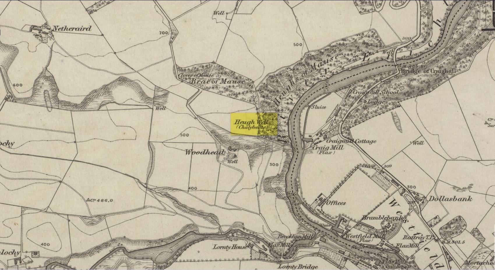
This little-known iron-bearing spring can still be found in the woodland known today as the Heugh of Mawse, a mile north of Blairgowrie. It was included in the Object Name Book of 1863, where they referred to an earlier account in the New Statistical Account, which told that,
“On the south end of it is a chalybeate spring much resorted to by the people of the locality. “There are one or two chalybeate springs in the parish; but they have never been chemically analyzed. There is one very fine spring called the “Heugh Well” It springs from the face of the “Heughs of Mause” (a mortar cliff of singular appearance; which descends abruptly into the bed of the river with an almost perpendicular declivity of about 200 feet) and judging from its colour, contains a considerable quantity of ferruginous matter. The use of its water has been found to be very beneficial in cutaneous eruptions, & affections of the Stomach.””
Heugh Well on 1867 map
Subsequently highlighted on the 1867 OS-map, a singular footpath led to the site and no further. It was mentioned by the regional historians J.G. McPherson (1885) and John MacDonald (1899), albeit briefly, where they respectively told that its waters were “formerly much resorted to by persons in the neighbourhood.” It possessed considerable medicinal properties which, according to tradition, were “found very beneficial for skin diseases and derangement of the stomach”! Doubtless such attributes will still be effective.
Sacred Wells (destroyed): OS Grid Reference – TF 32603 87555
Also Known as:
Little Wells
Archaeology & History
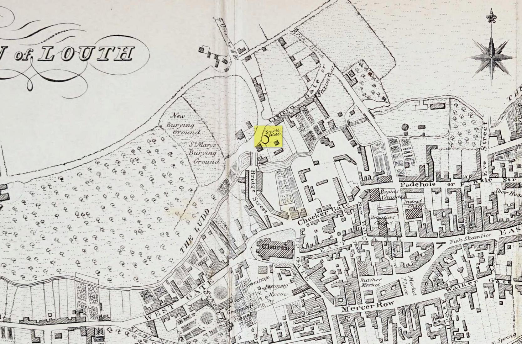
Small Well on 1834 map
Of the three wells in old Louth around which local ceremonies occurred, the Small Wells were apparently the least impressive. Its ritualised compatriots south of the River Lud in St. Helen’s Well and the Ash Well (the Aswell in modern Louth place-names) were reportedly the much better water supplies in bygone times. The site was highlighted on a map of the town in Robert Bayley’s (1834) history of the area, showing it as a small pool just below the Cistern Gate road; but when the Ordnance Survey lads came here later in the 19th century it had already gone.
It’s category here as a “sacred” well is due to it being annually decorated with garlands of flowers, commonly known today as well-dressing. Such wells tend to be places of pre-christian rites, attended by local people at dawn usually at Beltane or at Midsummer (St John’s Eve); but I’ve been unable to find out which was the sacred day when the waters here were honoured. All that we have left to tell us of the rites is from old township notes that said how,
““The small wells,” a cluster of little springs on the north of the town, shared in the honours of green boughs and popular huzzahs” the traditions held at the wells of St. Helen and Aswell a half-mile to the south.
A brief 16th century account told of a local man being paid for the adornment of the Small Wells: one “Henery Forman received for dressing small wells for a yeare – xiid” – or 12 pennies in old money. Not bad at all in them days!
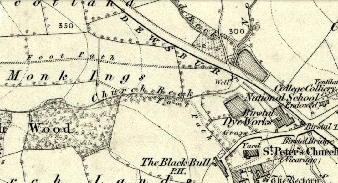
Seemingly built over in recent years, the Pickel Well was one of the main water supplies to the people of Gomersal and Birstall in earlier times. Getting its name, probably, from the northern dialect word pikel or pickel, meaning “very heavy rain” (Joseph Wright [1903] associates it with the expression “raining cats and dogs”), this may be a description of the heavy flow of water which helped feed the large man-made ponds either side of the road.
The Monk Ings Field in which it was found, derives its name from the monks from Nostell Priory who lived here, centuries ago. They would, no doubt, have drunk the water from this well.
Folklore
A very curious legend relates to this place. H.A. Cadman (1930) told,
“that whenever a birth was expected in Great Gomersal, a pad-foot came out at night from the Monk Ing fields and shouted out, ‘Thee first or me first!’ This was said to be a warning to people not to go out.”
Padfoots were phantom black dogs, stories of which occur all over northern England and beyond. They were ostensibly interpreted as omens of doom and bringers of Death. This example at Gomersal is peculiar in that it is equated with birth, as well as giving warnings for local people to stay indoors, as is more usual.
Incidences of black dogs at wells are not uncommon. In West Yorkshire alone we find them haunting the waters at Low Moor, Idle, Thorp Arch, Eccleshill, Heaton and others. Their nature is quite complex, but ostensibly derives from animistic cyclical notions of death and rebirth—hence their emergence sometimes from wells; and in this instance, presaging a local birth.
References:
Cadman, H. Ashwell, Gomersal, Past and Present, Hunters Armley: Leeds 1930.
Eliade, Mircea, Zalmoxis – The Vanishing God, University of Chicago Press 1972.
Wright, Joseph (ed.), English Dialect Dictionary – volume 4, Henry Frowde: London 1903.
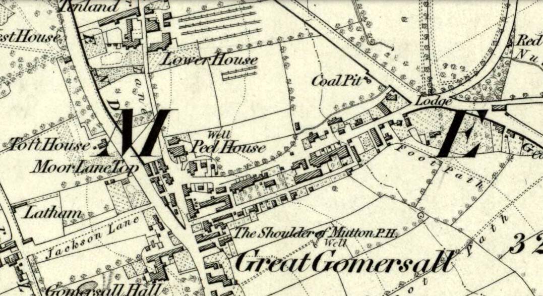
Not far from the old maypole, the Moor Lane Well was the innocuous-sounding site where legend told that a phantom horse was once seen running up and down the lane—said by old locals to be a “very ancient highway”. It was also a place where we find an intriguing tale of local disrepute, that brought humiliation to the culprit from the entire village.
There used to be a custom called ‘Riding the Stang’ which persisted in Yorkshire until the end of the 19th century. Thought to be of Scandinavian origin, it involved the culprit being hoisted onto a platform, held up by poles, then carried around the village where the person lived in a most ignominious procession. It was invariably described as being a public punishment and humiliation for faults made by one’s wife. Anyway, in the early 1840s, said H.A. Cadman (1930),
“there were two families who lived at Brecks Farm. I will not of course divulge their true names, so will describe one of them as the Jones family and the other as the Smith family. Jones’ wife accused Smith’s wife of having polluted the drinking water and the Smith family left the farm and removed to the top of Moor Lane. The Jones family wishing to make the most of the affair resolved that Mrs Smith’s effigy should ride the stang. A long pole was obtained and the effigy was affixed to the centre. Two men then took hold, one at each end, and walked up Moor Lane, folowed by a huge concourse of people. The procession stopped opposite Mrs Smith’s house and repeated the nominee. My informant, a dear old lady, would not tell me the whole of the verse, but it commenced thus:
“It’s neither your fault nor my fault that I ride this stang.”
“After all the verses had been repeated, the stang was taken round Gomersal, when ultimately the effigy was burned with the usual solemnities.
“The other instance of riding the stang occurred also in thge early ‘forties and I believe this was the last occasion of the stang being ridden. On this occasion a man…was in the habit of beating his wife harder than his neighbours thoughts proper with the result that he had to be punished. Now Jim was a most religious man, but the same rites had to be observed as in the other instance,
“It was for Jim Vasey that religious man
He paid her, he paid her indeed and
If Jim doesn’t alter his manners
We will take his skin “…….” to the tanners.
And if the tanner doesn’t tan it well,
We’ll send it to…”
“One must regret that the old custom of riding the stang has died out, as it must have had its good points.”
Local people could, of course, simply bring it back again! The Moor Lane Well was one of the main water supplies for the old villagers in bygone times, but seems to have disappeared under the modern houses. There is, however, a small narrow band of trees where the old waters once ran, amidst which it might still be found—if luck is on our side…
References:
Cadman, H. Ashwell, Gomersal, Past and Present, Hunters Armley: Leeds 1930.
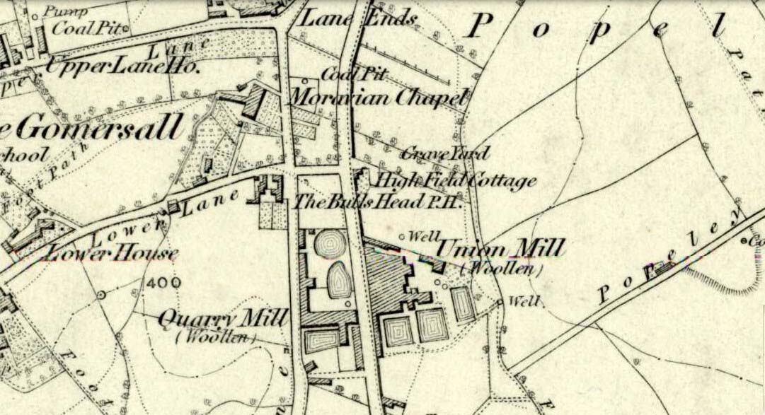
Originally called the ‘Manor Lea Well’ because it could be found on the far west of the land belonging to the Manor House, the name later became corrupted to ‘Mannerly’ by local folk. It was one of the four prime water supplies for this part of the old village, but it had other important social and festive rites attached that undoubtedly went back centuries. H.A. Cadman (1930) told that:
“On Palm Sundays it was the custom for boys to take bottles containing Spanish juice, treacle, and any other sweet thing they could, for the purpose of having them filled with the water from the well. The boys then exchanged bottles with each other and each sampled the others. It was said that no better water existed for this purpose.”
This particular ritual was integral to virtually every Spa Well from Wakefield through to the source of the River Calder.
A Mr G.W. Parker said that the well was to be found at the “extreme Western side” of Manor Lea and was “still in existence” when Cadman wrote about it in 1930, “behind Company Mill” not far from the Moravian Burial Ground. Do any local historians know if the well is still there, or has it since been destroyed?
References:
Cadman, H. Ashwell, Gomersal, Past and Present, Hunters Armley: Leeds 1930.
Healing Well (lost): OS Grid Reference – SE 209 260?
Archaeology & History
This bizarre-sounding well owed its name—if we are to accept H.A. Cadman’s (1930) version of history—to the local land-owner,
“Joseph Mortimer and it was so-called because Mortimer’s christian name was Doidy Poidy.”
But this seems unlikely. The term ‘doidy’ is a local dialect word, seemingly found only in West Yorkshire, meaning ‘an overdressed person, especially female,’ (Haigh 1928), with doidy-poidy being rhyming slang for the same thing. The english dialect magus, Joseph Wright (1900), proclaimed the same derivative, “a badly dressed woman, a dowdy.” So it may have been that this title was endowed upon Mortimer’s wife.
Cadman told that the Doidy Poidy Well was one of the “chief wells” of Gomersal, implying that its waters were good and strong. Its existence on what was known as “the old feasting grounds” may have played a part in the “public rejoicings which last for days… The feast was on the Monday on or before Lady Day.” (March 25th, around spring equinox) However, Cadman assures us that the celebrations were started “when the Gomersal Cloth Hall was opened,” telling us that “this feast or fair is not therefore an ecclesiastical one.”
The exact whereabouts of the Doidy Poidy Well remains a mystery (the map-link, above, shows an approximation from the middle of Gomersal).
References:
Cadman, H. Ashwell, Gomersal, Past and Present, Hunters Armley: Leeds 1930.
Haigh, W.E., A New Glossary on the Dialect of the Huddersfield District, Oxford University Press 1928.
Wright, Joseph (ed.), English Dialect Dictionary – volume 2, Henry Frowde: London 1900.
From the west end of Prince Street in Edinburgh central, take the (A90) Queensferry Road. Go along here for 2.2 miles (3.5km) where the A90 meets the A902. Keep going west along Hillhouse Road for literally 1km (0.62 miles) where you reach a crossroads with the B9085 and there are trees on the right (north) side of the road. Go into these trees and, before you come out into the fields on the other side, about 150 yards in, walk to your right and zigzag about in the undergrowth. A small muddy pond is what you’re looking for!
Archaeology & History
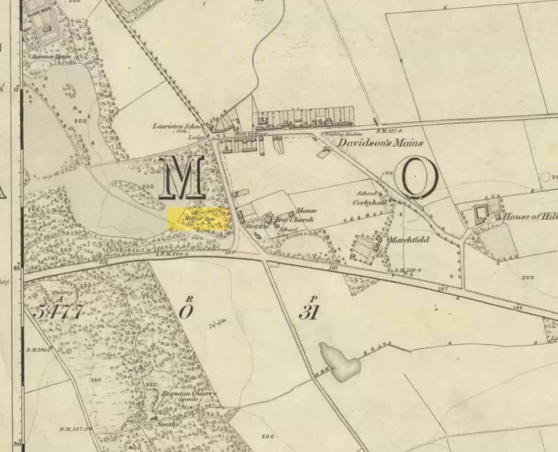
Out towards old Lauriston Castle on the northwestern outskirts of the city, these all-but forgotten healing waters became renowned for a short period of time in the latter-half of the 18th century. They were described in John Law’s Parish of Cramond (1794) where, with some brevity, he told that,
“On the lands of Marchfield is a spring of mineral water called the well of Spaw, reckoned beneficial in scorbutic cases, and highly purgative if drunk copiously.”
It was highlighted in the trees on the earliest OS-map (above) and its ruined remains can still be found. Stone-lined, the watery remains of this old healing well (undoubtedly a place used by local people before the toffs named it as a ‘spa’) are thankfully still running. Two other spa wells could be found not far away: one at Lauriston castle, and the other at Barnton.
From Ilkley go up to Middleton and from there go up Harding Lane and, where the road bends left a track goes straight north onto the moors. Go up this until you’re onto the moor proper. Keep going until you’re following the line of walling, where a small stream is trickling right by your right-hand side. Follow this to its source a coupla hundred yards up. Stop!
Archaeology & History
Middleton Moor CR483: single cup-and-line
First mentioned by Stuart Feather in 1965, this simple cup-marking has a long line squirming away to the edge of the rock on which it’s carved. The cup-marking is some 3 inches across and about ½-inch deep, with the long line about 24 inches long. There’s really nowt much to look at here unless you’re a real cup-and-ring freak — though note that the carving occurs on a broken piece of stone just where a spring of water emerges from the ground. Some archaeo’s have a notion that sometimes our cup-and-ring stones have some sorta relationship with water — though they’re not into sticking their necks out and saying anymore than that! And of course, some carvings obviously relate to water. This one here is a strong contender, with the long wiggly line perhaps representative of the stream running from its source, which itself is the cup-mark.
However, we might just aswell surmise that the carving here was executed by some bored teenager, just testing out his first antler pick, or flintstone, telling his mates, “I woz ‘ere!”
References:
Boughey, Keith & Vickerman, E.A., Prehistoric Rock Art of the West Riding, WYAS 2003.
ather, Stuart, ‘Cup and Ring Boulders,’ in the Cartwright Hall Archaeology group Bulletin, 10:7, July 1965.
The local historian, H.B. McCall (1910) described this ‘Saint Lambert’s fountain’, as it was first called, in his fine work on local churches, telling of its early description in the 12th century, saying:
“This is a very early mention of St. Lambert, the patron saint of the church and parish (of Burneston). The fountain or well was probably situated in what is now the new portion of the churchyard, and the rivulet is now enclosed as a drain. The name of the wapentake of Halikeld is said to be derived from St. Lambert’s Well at Burneston.”
I can find little else about these old healing waters. Anyone got anymore info?
References:
McCall, H.B., Richmondshire Churches, Elliott Stock: London 1910.
Go through Haworth and head for the well-known Penistone Hill country park. On the far western side of the hill up near the top of Moorside Lane, there’s a car-park. Right across the road from this there are two footpaths: one heads you into the moor, whilst the other (going the same direction) follows the edge of walling onto the moors. Take this path. Walk on and downhill, past the end of the reservoir, then the path continues uphill. You’ll hit a nice cheery tree beside the path a few hundred yards up. Stop here, look into the boggy region with bits of walling on the moor in front of you. That’s where you’re heading!
Archaeology & History
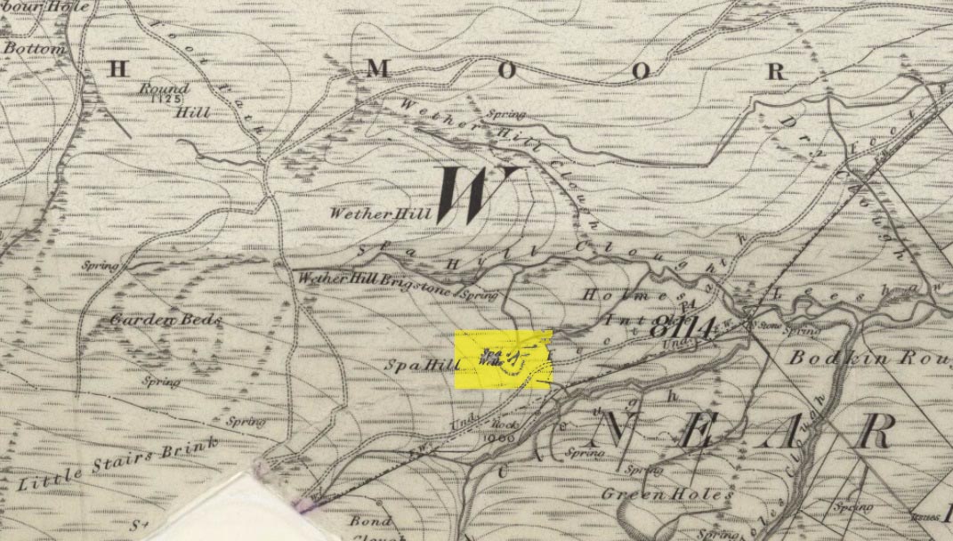
The first, weaker of the Spa Wells
This was a really curious spot to me, as I found absolutely nothing about the damn place! But thanks to the assistance of local historian and writer Steven Wood (2009), that’s changed. Shown on the 1852 OS-map, at least two springs of clear water trickle slowly from the wet slope above you into the boggy reeds. Close by there are overgrown remains of old buildings, covered with the time of moorland vegetation, seemingly telling that the waters were collected for bathing rooms. But who the hell even started the notion that they’d be able to get Victorian rich-folk up here at the crack-of-dawn to drink or bathe in the waters is seemingly forgotten. And, as is evident from the lack of local history, the project was a failed one which seemed not to have lasted too long.
Folklore
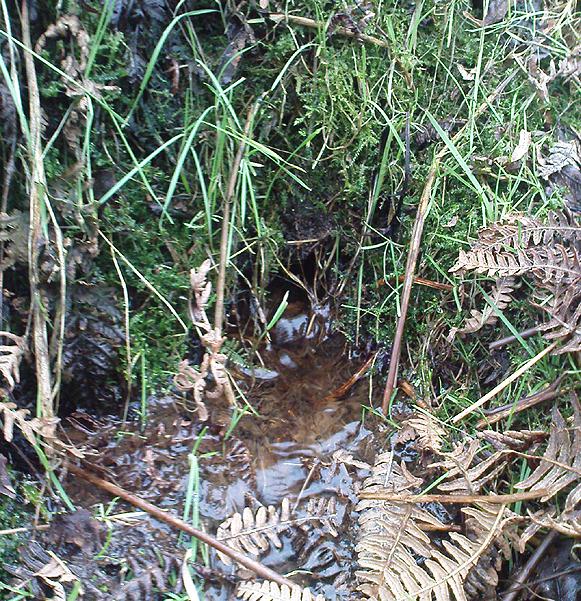
The stronger Spa Well
It was quite obvious that of all the springs around here and despite the strong-flowing streams either side of these spa well, that the local animals drink here more than the other nearby springs of water, as there were literally hundreds of animal tracks all across the boggy ground of the spas.* The waters also seem to have the usual ‘spa’ qualities of stinking, but once we’d cleaned out the overgrown springs — which looked as if they hadn’t been touched for 100 years or more — the waters were clear and tasted good, and were curiously slightly warm!
Although my initial search for information on this site drew a blank, Steve Wood pointed us in the right direction for info on the place. As with many other holy wells and spas in Yorkshire, it turned out that this was another spot much revered around Beltane, indicating strongly there would have been earlier pre-christian rites practiced at this site. Steve pointed me to Martha Heaton’s (2006) local history work, which told:
“For many years the first Sunday in May was a special day. It was known as Spa Sunday, for on this day people gathered up in the hills overlooking what is now Leeshaw Reservoir, here was a well, known as Spa Well, and the stream which now feeds the reservoir is known as Spa Beck. People came from Haworth, Oxenhope, Stanbury, and other villages sitting round the well, they sang songs, some bringing their musical instruments to accompany the singing. Children brought bottles with hard spanish in the bottom filling the bottle with water from the well, shaking it until all the spanish or liquorice had been dissolved. This mixture was known as ‘Poppa Lol’ and would be kept for weeks after a little sugar had been added, then it was used sparingly as medicine. The custom seems to have died out when Bradford Corporation took over the water and made Leeshaw Compensation Reservoir in 1875, though up to about 1930 two men from Haworth would wend their way to the spot on the moor, the first Sunday in May. The men were John Mitchell and Riley Sunderland, better known, in those days as ‘Johnny o’Paul’s’ and ‘Rile Sun’.
It was a great day for many people, the Keighley News of May 1867 mentioned it, the report of local news reads thus: ‘A large assembly met on Spa Sunday on the moors about two miles from Haworth, and a party of musicians from Denholme performed sacred music’.
This locality was often visited during the summer months by the Bronte family.”
References:
Heaton, Martha, Recollections and History of Oxenhope, privately printed 2006.
Wood, Steven & Palmer, Ian, Oxenhope and Stanbury through Time, Amberley Publishing 2009.
Acknowledgements: – Huge thanks to Steven Wood for his help; and to Hazel Holmes for permission to quote from Martha Heaton’s work.
* A common creation myth behind many healing wells is that animals with breaks or illness drag themselves to drink from otherwise small or insignificant springs and wells, despite of the copious streams or rivers which may be nearer.