Hanging Stones, Ilkley Moor, West Yorkshire

Cup-and-Ring Stones:  OS Grid Reference – SE 12818 46761

Also Known as:

  1. Carving no.126 (Hedges)
  2. Carving no.284 (Boughey & Vickerman)
  3. Fairies Kirk
  4. Hangingstones

Getting Here

Looking up (south) at the site

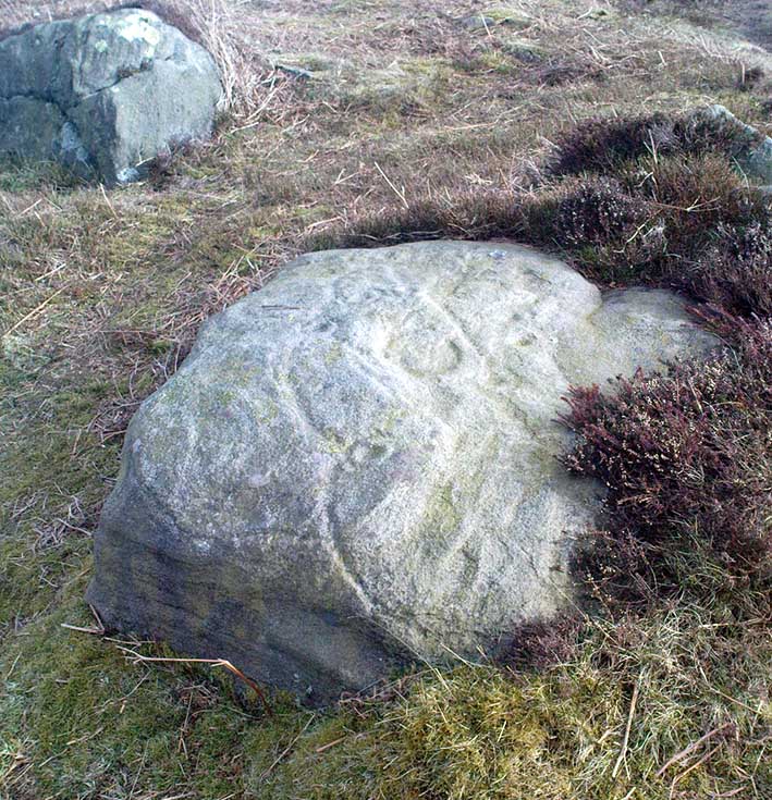
Head up to the Cow & Calf Rocks and walk to the large disused quarry round the back (west).  You’ll notice a scattered copse of old pine trees on the edge where the hill slope drops back down towards Ilkley; and there, two raised hillocks (unquarried bits) rise up where the pine trees grow.  The carvings are on the flat rocks atop of one of the two hillocks.  If you’re walking up from Ilkley, once you’ve crossed the cattle-grid in the road and the moorland slope opens up above you, just walk uphill towards the copse of trees and watch out for the rock outcrop in the picture here.

Archaeology & History

Very well-known to locals, folklorists and archaeologists alike, the remains of these old glyphs have caught the attention of artists, historians and Forteans alike for the images and tales surrounding them.  It was obvious that in times past, that the carved remains that we see today would have extended considerably further, but the quarrying destroyed much of it.  Indeed, we’re lucky to have this small section of carved rock still intact!

J.Thornton Dale's 1878 drawing
J.Thornton Dale’s 1878 drawing
Different carved section (J.Thornton Dale 1878)

The rocks were first described as the Hanging Stones in the local parish records of 1645, and their name probably derives from the old-english word hangra, meaning ‘a wood on a steep hill-side,’ which is very apt here.  The first known description of the site as possessing cup-and-rings appears to have been in a small article in the local Leeds Mercury newspaper in 1871.  Several years later J. Romilly Allen (1879) wrote a lengthier descripton of the site:

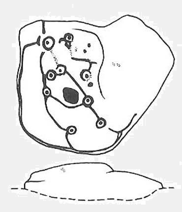
“The crags from which these masses have been detached are known by the name of hanging stones, and at their eastern extremity is a large quarry. Between this quarry and the overhanging edge of the cliff a portion of the horizontal surface of the rock was some years ago bared of turf, thereby disclosing the group of cup and ring sculptures shown on the accompanying drawing. It will be seen that the design consists of twenty-five cups of various sizes, from 1 to 3 inches in diameter. Seven of the cups are surrounded by incomplete rings, many of them being connected by an irregular arrangement of grooves. The pattern and execution are of such a rude nature as almost to suggest the idea of the whole having been left in an unfinished state.  The sides of the grooves are not by any means smooth, and would seem to have been produced by a process of vertical punching, rather than by means of a tool held sideways.”

Allen and other archaeologists from this period saw some considerable relevance in the position of this and the many other cup-and-rings along this geological ridge, telling:

“The views obtained from all points over Wharfedale are exceedingly grand, and this fact should not be lost sight of in studying remains that may have been connected with religious observances, of which Nature worship formed a part.”

J. Romilly Allen’s 1879 drawing of the carvings
Water-assisted double-ring on eastern rock

A common sense point that seemed long-lost to many archaeologists, adrift as they went in their measurements of lithics and samples of data charts for quite a number of years.  In recent years however, this animistic simplicity has awakened again and they’ve brought this attribute back into their vogue.  Let’s hope they don’t lose sight of it again!

There are tons of other archaeological references to this fine set of carvings, but none add anything significant to anyone’s understanding of the nature of the designs.  We must turn to psychoanthropology, comparative religion and folklore if we want to even begin making any realistic ‘sense’ (if that’s the right word!) of this and other cup-and-rings.  Curiously, the nature of this and other carvings is a remit archaeology has yet to correctly engage itself in.

Hanging Stones with “21st century informal unauthorised carvings”

On a very worrying note, we need to draw attention to what amounts to the local Ilkley Parish Council officially sanctioning vandalism on the Hanging Stones, other prehistoric carvings and uncarved rocks across Ilkley Moor.  As we can see on a couple of photos here, recent vandalism has been enacted on this supposedly protected monument.  Certain ‘officials’ occasionally get their headlines in the local Press acting as if they’re concerned about the welfare of the ancient monuments up here, but in all honesty, some of them really don’t give a damn.  The recent vandalism on this stone and others has now been officially recognised as an acceptable “tradition” and a form of — get this! — “twentieth / twenty-first century informal unauthorised carving” and has been deemed acceptable by Ilkley Parish Council as a means to validate more unwanted carving on the moorland “in the name of art”!  Of course, their way of looking at this has been worth quite a lot of money to a small group of already wealthy people. But with Tom Lonsdale and Ilkley Council validating or redesignated ‘vandalism’ as “twenty-first century informal unauthorised carvings”, this legitimizes and encourages others to follow in their shallow-minded ignorant footpath, enabling others with little more than a pretentious ‘care’ for both environment and monuments to add their own form of ‘art’ on cup-and-ring carvings, or other rocks on the moors.

Hanging Stones with more “21st century informal unauthorised carvings”

You can see in some recent vandalism — sorry, traditional “twentieth / twenty-first century informal unauthorised carving”  — at the top-right of the Hanging Stones photo to the side, a very ornate ‘Celtic’-style addition, akin to the quality carved by well-known stone-mason Pip Hall who, coincidentally, has now been granted a lot of money to “officially” carve her own work on another stone further down the valley from here.  With Miss Hall, Mr Lonsdale, poet Simon Armitage and Ilkley Parish Council each playing their individual part in encouraging what is ostensibly vandalism…errr…sorry – I keep getting it wrong – I mean traditional “twentieth / twenty-first century informal unauthorised carving” on the Hanging Stones monument and other cup-and-ring stones on the moor, we can perhaps expect a growth industry in this field…..especially if you’re wanting to make more money for yourself in the name of art or poetry.  And if you apply to Rachel Feldberg of the Ilkley Arts Festival, you may get good money for your work… Seriously! (this is no joke either)

Please contact Ilkley Parish Council and other relevant authorities and express your dismay at their lack of insight and concern for the knock-on effects of their decisions on this matter.  Other plans to infringe even further onto Ilkley Moor are in the business pipeline…

Folklore

Just underneath the carved overhanging rocks (walk off the knoll to the bottom of the rocks, facing the town), is a small recess or sheltered cavity which, told Harry Speight (1900),has

“From time immemorial (been) known as ‘Fairies’ Kirk’, and traditions of it having been tenanted by those tiny sprites, the fairies, still exist among old people in the neighbourhood.”

Tradition goes on to tell that when the Saxons arrived here, they were wont to build a christian church by the Hanging Stones, but the little people strongly resented this and fought hard against the invading forces.  As the Saxons started building the edifice of the new religion, during the night the fairy folk took down the stones and moved them into the valley below.  In the morning when the Saxons found this had happened, they carried the stones back up to begin building again; but each night, the fairy folk emerged and again took the stones to the valley bottom again.  Eventually, after much hardship, the Saxon folk gave up the idea of building on the Fairie’s Kirk, as it was known, and the church that still remains in Ilkley centre was decided as an easier place to build their edifice.

Traditions such as this (of fairies moving stones back to whence they came, or away from ancient archaeological sites) are found throughout Britain and appear to be simple representations of the indigenous peasant hill-folk who strongly objected to their own sacred sites (rocks, trees, wells, etc) being supplanted by the invading religious force.

In more recent years the observation of curious light phenomena over these rocks have been seen, both over here and the Cow & Calf Rocks…

References:

  1. Allen, J.R., ‘The Prehistoric Rock Sculptures of Ilkley,’ in Journal of the British Archaeological Association, vol.35, 1879.
  2. Bennett, Paul, The Old Stones of Elmet, Capall Bann: Milveton 2001.
  3. Bogg, Edmund, Higher Wharfeland, James Miles: Leeds 1904.
  4. Collyer, Robert & Turner, J. Horsfall, Ilkley: Ancient and Modern, William Walker: Otley 1885.
  5. Gelling, Margaret, Place-Names in the Landscape, Phoenix: London 2000.
  6. Hedges, John (ed.), The Carved Rocks of Rombald’s Moor, WYMCC: Wakefield 1986.
  7. Leeds Mercury, ‘Prehistoric Remains at Ilkley’, 20 April, 1871.
  8. Michell, John, The Earth Spirit: Its Ways, Shrines and Mysteries, Thames & Hudson: London 1975.
  9. Size Nicholas, The Haunted Moor, William Walker: Otley 1934.
  10. Smith, A.H., English Place-Name Elements – volume 1, Cambridge University Press 1956.
  11. Speight, Harry, Upper Wharfedale, Elliott Stock: London 1900.

© Paul Bennett, The Northern Antiquarian


Worm Well, Fatfield, Durham

Sacred Well: OS Grid Reference – NZ 3115 5401

Getting Here

This seems a bittova cheat really – and on two counts: i) I aint been here yet; and ii) we’re not sure that there’s any remains left to be seen.  But these notes might produce a result, so direction pointers are worthwhile I reckon!  Various ways to come, but you need to end up on the weird-sounding Bonemill Lane – whether you get there via Worm Hill Terrace or Biddick Lane aint important.  Once on the right road, you wanna stand by the supposedly haunted Biddick Inn, and walk down the road a short distance until you reach a path on your right which heads up towards the ruined Worm Hill.  Halfway along here – or thereaboots – the old Worm Well could once be seen.

Archaeology & History

This was initially very difficult to pin down with any certainty, though after a few hours investigation, Keighley archives researcher Michala Potts found it highlighted on a field-map of the region from 1750, as the illustration here clearly shows.

Map highlighting the Worm Well, 1750
Map highlighting Worm Well, 1750

During its “missing years”, several accounts describe the well as being between Worm Hill and the River Wear, which is what’s clearly shown here.  So the possible confusion there may have been (which I initially had aswell) between the riverside spring opposite the pub and the now missing Quarry Well on the far western side of Worm Hill, can at least been dispelled.   The position of the site was described by the holy wells writer, Alan Cleaver [1985], who told that “the well still exists, having been restored in 1974, at the foot of Worm Hill at Penshaw on the north bank of the river.”  Local history records tell that a plaque commemorating the site was put here the same year; and this note is again confirmed in Paul Screeton’s [1978] excellent survey of the dragon legends hereabouts.  Records from the mid-18th century tell that the Worm Well possessed “a cover and an iron dish or ladle” (Binnall & Dodds 1943) to protect the waters.

Folklore

We find from old records that in the middle of the 18th century, “it was a wishing well and a place of festivity on Midsummer Eve.”  The common veneration of crooked pins were offered at this legendary site.

…And then, of course, we have the great Legend of the Lambton Worm, whose spirit form gives this site so much importance.  This well-known folk-tale tells that the great serpent emerged from this very water source.  In this renowned creation myth of the landscape, and the sites upon it, we have the dragon, the cailleach, the waters, and more…

In a recent narrative of the Lambton Worm story, author Karen Liebreich (2012) sent us an excerpt from her new book, UneXplained: Spine-tingling tales from Real Places in Great Britain and Ireland, which outlines more of the tale.  Karen writes:

“Simon, the heir to Lambton Castle, was a wild boy who never paid attention to his lessons or his elders. He liked only to play with the local boys from the village and their games were rough and annoyed other people. They went joy-riding with carts and donkeys, they stole apples from the trees, they frightened younger children. They liked to go hunting for rabbits and fishing for eels in the local river. The lord of the manor, Simon’s father, thought his son should behave better since one day he would be in charge. Simon could not be bothered.

“One Sunday, when he should have been in church, Simon played truant with Stephen, his friend, and two other boys from the village, and went fishing in the river Wear.  After hours of dull waiting, chatting and eating their picnic, Simon caught a strange-looking animal. It did not look like the regular eels and small fish they usually caught. It was no longer than his finger, dark green and with two little fins on its back. Its skin was rough and scaly, and it had four short legs, with sharp clawed feet. Its face was repellent, with a long pointed snout, twelve little teeth sharp as pins, and red glowing eyes.

“Stephen peered over Simon’s shoulder at the animal. “Yuk, throw it back,” headvised. But Simon had caught nothing else, and he was intrigued by the little beast. He put it in his pouch. As the boys walked home, kicking stones and chatting, they noticed a foul smell. It came from Simon’s pouch. They were just passing the well by the castle, so Simon tossed the squirming worm in, and promptly forgot all about it….”

Read the rest of the story in on Kindle at – http://amzn.to/SsjKK6

…to be continued…

References:

  1. UneXplained - LiebreichBinnall, P.B.G. & Dodds, M.H., ‘Holy Wells in Northumberland and Durham,’ in Proc. Soc. Antiq. Newcastle-upon-Tyne, 4th series, volume 10:2, January 1943.
  2. Cleaver, Alan, ‘Holy Wells – Wormholes in Reality,’ in Source magazine, no.3, November 1985.
  3. Liebreich, Karen, UneXplained: Spine-tingling tales from Real Places in Great Britain and Ireland, Kindle 2012.
  4. Screeton, Paul, The Lambton Worm and other Northumbrian Dragon Legends, Zodiac House: London 1978.

© Paul Bennett, The Northern Antiquarian


Creag na Cailleach, Killin, Perthshire

Sacred Mountain:  OS Grid Reference – NN 5640 3715

Also known as:

  1. Creag na Caillich

Getting Here

Another silly-sounding directional pointer!  Get to the now tourist-infested town of Killin (best in Winter, when the town is quiet and you get to know the locals a lot better) and travel through it as if you’re going to follow Loch Tay up its western side.  As you’re going out of the village towards the Bridge of Lochay Hotel (an excellent place), you’ll see an amphitheatre of mountains in the background.  The tallest of the hills on the left is where you’re heading.  Go straight up the hillside and follow your nose!

Creag na Cailleach, Perthshire
Creag na Cailleach, Killin

The hill guards the entrance to the legendary Glen Lochay (Valley of the Black Goddess).  There are many ways to climb her, but my first venture here took me up the waterfalls and steepish burn of Allt na Ceardaich.  Once on the level, I found myself surrounded by that amphitheatre I mentioned, from where – on my first visit – I took up the sheer face of this great mountain. (to be honest it’s nowt special if you’re into mountaineering) From the tops you’ve got a damn good view all round.  But respect this old hill, as danger awakens to idiots who would think themselves champions.

Folklore

Here, where axes were quarried by ancient man from beneath Her rocky slopes, this ‘Hill of the Old Woman’, or ‘Hag’, was one of the abodes of the primal Mother Goddess in olden times, so says her name.  Her ‘dark’ aspect seemed manifest one time when I climbed her with a rather stupid man in tow.  Following one of the streams back into the valley below, he thought it wise to copy my gazelle-nature as I sprang without thought, quickly, from rock to rock, bouncing at speed down the fast-flowing stream  (which takes a lotta weird practice and very strong ankles!), in spite of the advice to do otherwise – and in doing so he broke his leg in three places and, to make it worse, had to spend the night there in complete agony!

Don’t tell me there’s no ‘dark’ goddess to some of these great places!

Axe production has been found to have occurred as early as 2500 BC.  There have been numerous flint finds hereabouts aswell – but considering this is a mountain, you’d expect to find something on or about Her slopes!

I’ve just been back up here as the first good snow fell upon the hills and the white cover brought the elements out of her form in a way I’d not seen before.  Tis a wonderful place the Creag na Cailleach; and, it seems, a site that played a now forgotten part in the ancient name of the glen, Lochay, which was the living abode of the Black Goddess in more archaic days.  Twouldst be good to hear some of the authentic old stories from old locals that were once known of this ancient deity in the glens.  If anyone knows of such tales, let us know before they are lost forever…

References:

  1. Ritchie, P.R., ‘The Stone Implement Trade in Third Millenium Scotland,’ in Coles & Simpson’s, Studies in Ancient Europe, Leicester University Press 1968.

Acknowledgements:  Huge thanks to Lindsay Campbell for her hospitality, food and roof hereby.

© Paul Bennett, The Northern Antiquarian


Map Stone, Ilkley Moor, West Yorkshire

Cup-and-Ring Stone:  OS Grid Reference – SE 12961 46396

Also known as:

  1. Carving No.137 (Hedges)
  2. Carving No.295 (Boughey & Vickerman)
  3. Planet Stone
  4. The Planets Rock

Getting Here

Map Stone, looking east

Best visited in winter and spring – thereafter the vegetation can hide it a little – but even then, it’s not too hard to find.  Start from the Cow & Calf Hotel and walk across the road onto the moor, and head over as if you’re gonna walk above the Cow & Calf Rocks, onto the moorland proper.  When you’ve gone a few hundred yards, walk up the slope (there are several footpaths – you can take your choice).  Once on the ridge on top of the moor proper, you’ll see the Haystack Rock: it’s on the same ridge, right near where the moor drops down the slope about 250 yards west of here, just about next to the footpath that runs along the edge.  Look around!

Archaeology & History

Unlike some folk who’ve seen this old stone, I find this carving superb.  Its one of my favourites up here!  Its alternative name – the Planet Stone – perhaps lends you to expect something more, but this is down to the astronomer who thought this was some type of heavenly image (which is most unlikely).  I prefer to call it the ‘Map Stone’ because the correlates this carving has with indigenous aboriginal cup-and-rings is impressive and — to Aborigines anyway — would have all the hallmarks of a map.  But not a ‘map’ in the traditional sense of modern humans.  The incidence of cups and rings linked by curvaceous lines, typifies routes between water-holes or settlement spots made by ancestral beings — which is just what we find at this carving here.  These ancestral beings need to be seen in a quite mythic sense: they may be creation deities (giants, gods, etc), animal spirits, the routes of shaman spirits, or other expressions of homo-religiosus.

Map Stone (note the carved line along the very edge of the rock)
…and again from another angle

In the Map Stone here, we see that the very edge of the rock (fig.2 & 3) is ‘encircled’, perhaps (and I say perhaps) symbolic of the edge of the world.  The lines and rings upon the top of the rock may symbolize journeys to and from important places.  Another impression I get of this carving, with the “map” idea, is that the large pecked diamond-shaped ‘cup’ near the middle of the carving is a large body of water around which the archaic routeways passed.  The next time anyone visits this stone, have a look at it with this idea in mind.  Its simple, straightforward and makes sense (mind you – that doesn’t mean to say it’s right!).

The first account I’ve found of this comes from the pen of J. Romilly Allen (1882), where this stone “measuring 5ft 3in by 5ft, and 1ft 9in high” was described thus:

“On its upper surface, which is nearly horizontal, are carved thirteen cups, varying in diameter from 2 to 2½ in, eleven of which are surrounded by rings.  There is also an elaborate arrangement of connecting grooves.”

Although we can only work our nine cup-and-rings here today, Mr Allen seemed suitably impressed with this old carving. Stan Beckensall (1999) seemed to have a good feel of this design too, describing it thus:

“Two thirds of the surface of this earthfast sandstone have been used in a design that partly encloses the marked part of the rock with long curvilinear grooves along its edge, and the inner grooves link single rings around cups.  The effect is one of inter-connection and fluidity.”

The Map, or Planets Stone (after Hedges 1986)
Hedges 1986 sketch

The Map Stone was also looked at to examine the potential for Alexander Thom’s proposal of a megalithic inch: a unit of measure speculated to have been used in neolithic and Bronze Age times for the carving of cup-and-ring stones.  Using nine other carvings on these moor as samples, Alan Davies (1983, 1988) explored this hypothesis and gave the idea his approval.  However the selectivity of his data, not only in the carvings chosen, throws considerable doubt on the idea.  Unfortunately the idea doesn’t hold water.  The ‘geometry’ in the size of cup-and-rings relates more to the biometrics of the human hand and not early scientific geometry, sadly….

References:

  1. Allen, J.R., ‘Prehistoric Rock Sculptures of Ilkley,’ in Journal British Arch. Assoc., 35, 1879.
  2. Allen, J.R., ‘Notice of Sculptured Rocks near Ilkley, with some Remarks on Rocking Stones,’ in Journal British Arch. Assoc., 38, 1882.
  3. Allen, J.R., ‘Cup and Ring Sculptures on Ilkley Moor,’ in Reliquary Illus. Archaeology, 2, 1896.
  4. Beckensall, Stan, British Prehistoric Rock Art, Tempus: Stroud 1999.
  5. Boughey, K.J.S. & Vickerman, E.A., Prehistoric Rock Art of the West Riding, WYAS: Exeter 2003.
  6. Collyer, Robert & Turner, J.H., Ilkley: Ancient and Modern, William Walker: Otley 1885.
  7. Cowling, E.T., Rombald’s Way, William Walker: Otley 1946.
  8. Davis, Alan, ‘The Metrology of Cup & Ring Carvings near Ilkley in Yorkshire,’ Science Journal 25, 1983.
  9. Davies, Alan, ‘The Metrology of Cup and Ring Carvings,’ in Ruggles, C., Records in Stone, Cambridge 1988.
  10. Hedges, John, The Carved Rocks on Rombald’s Moor, WYMCC: Wakefield 1986.
Alan Davies' image of the carving - with carved 'lake' near centre
Alan Davies’ image of the carving – with carved ‘lake’ near centre

© Paul Bennett, The Northern Antiquarian


The Great Stone, Downham, Lancashire

Legendary Rock:  OS Grid Reference – SD 78212 44402

Also Known as:

  1. Downham Cross (Byrne 1974)

Getting Here

The best way to locate this is probably by starting from the pub opposite the old church of St. Leonard and heading west along the village road, past three large gate-entrances, until reaching the conspicuous milestone by the road junction.  On the other side of the road, just before the gate entrance to Downham Hall, edged into the base of the wall, we find this ‘ere The Great Stone.

Archaeology & History

The Great Stone, Downham

What a truly beautiful little village we find in Downham, nestled quietly and with age at the northern edge of Pendle hill.  It’s tucked away, off any main road so maintaining its sense of age and almost reclusive nature.  There is hidden history a-plenty scattering the landscape here, but tales of our Great Stone — thought by some as an old monolith; remains of a Roman milestone by others; whilst some just denote it as nowt but a small stone — is what brought me here.  It’s name betrayed my expectation (I always hope for too much it seems…), but the small pock-marked stone has been embedded in its present position for at least 150 years, as the growth of soil and tree behind it shows.  Archaeo-historians say little of it (reputations y’ know!) until something substantial is found; but thankfully we came upon the lovely couple who are Lord and Lady Clitheroe of Downham Hall, who told us more…

Folklore

“There are a couple of humourous legends told of the Great Stone,” Lord Downham began… But to a (sometimes) courteous megalithomaniac like myself, the tales rang the all-too-familiar bell.

Close-up of the Great Stone

The original position of the stone, though not known for certain, was some short distance away either across the road, or further along in a nearby field.  When it was moved – Lord Downham said around 1830 – the remains of a body were found beneath it; but another source told in fact that it marked “the final resting place of two legionaries who died on the nearby Roman road during trouble with the Brigantes.” (An old Roman road is nearby)  But apparently this old stone also moves. When the church bell strikes midnight the stone is said to turn itself around upside-down. Where have we heard that before!?

The site is described in Clifford Byrne’s (1974) unpublished manuscript on the crosses of Lancashire, where he cites it as being the remains of a cross pedestal, but adds that “if ever a cross stood by the village green, no memory of seems now to exist.”  But Mr Byrne also described the all-too-familiar heathen folk tales, saying:

“A local man told the writer that the object is called Downham Stone and that it turns over every night at midnight.  We read elsewhere that the boulder is called “the great stone of Downham” and that it turns at the stroke of midnight by the church clock.”

References:

  1. Byrne, Clifford H., “A Survey of the Ancient Wayside Crosses in North East Lancashire,” unpublished manuscript, 1974.
  2. Lofthouse, Jessica, Three Rivers, Robert Hale: London 1946.
  3. Lofthouse, North Country Folklore, Robert Hale: London 1976.
  4. Winterbottom, Vera, The Devil in Lancashire, Cloister: Stockport 1963.

© Paul Bennett, The Northern Antiquarian


Sowerby Lad, Mytholmroyd, West Yorkshire

Standing Stone (destroyed): OS Grid Reference – SE 024 244

Archaeology & History

Standing stone on 1894 map

Also known as the Field House Standing Stone, this monolith seems to have gone.  It was first described in local Minister’s Accounts of 1403, and then again in the Wakefield court-rolls of 1515.  By the time John Watson (1775) wrote about the place there had been several other references describing this old “standyngstone”. It was still upright in 1852, but Ordnance Survey showed it as “Site of – ” at the beginning of the 20th century, and the stone had been moved a short distance away, further down from its original position to a spot at the side of the old trackway — but all trace of it has since vanished.

Folklore

This is thought to have been the standing stone which Robin Hood threw here, from the appropriately called Robin Hood’s Penny Stone at Wainstalls. The tale tells how he dug it out of the ground with a spade and threw it three-and-half miles across the valley until it landed here. Ooh, what a strong boy!

References:

  1. Bennett, Paul, The Old Stones of Elmet, Capall Bann: Milverton 2001.
  2. Smith, A.H., The Place-Names of the West Riding of Yorkshire, volume 3, Cambridge University Press 1961.
  3. Watson, John, The History and Antiquities of the Parish of Halifax, T. Lowndes: London 1775.

© Paul Bennett, The Northern Antiquarian


Robin Hood’s Penny Stone, Wainstalls, West Yorkshire

Stone Circle (destroyed):  OS Grid Reference – SE 046 288

Archaeology & History

The Pennystone on 1852 map

All remains of this site, first mentioned as a stone circle in 1836, have gone. The place could be found by the appropriately named Stone Farm at the top end of Wainstalls and was first mentioned by John Watson (1775), who strangely said nothing about any circle here.  However, this changed when John Crabtree (1836) arrived and described a ring of stones surrounding a large boulder in the centre (illustrated here). The boulder itself was actually called the Robin Hood Penny Stone.

Folklore

Watson's 1775 drawing
Watson’s 1775 drawing

This was one of the many legendary sites from where our legendary outlaw practiced shooting his arrows.  He was also said to have picked up and thrown a large standing stone from this spot, until it landed three-and-a-half miles away on the hillside on the other side of the Calder Valley. (this was known as the Field House, or Sowerby Lad Standing Stone)

References:

  1. Bennett, Paul, The Old Stones of Elmet, Capall Bann 2001.
  2. Crabtree, John, Concise History of the Parish and Vicarage of Halifax, Hartley & Walker: Halifax 1836.
  3. Dobson, R.B. & Taylor, J., Rymes of Robyn Hood, Alan Sutton: Gloucester 1989.
  4. Faull, M.L. & Moorhouse, S.A., West Yorkshire: An Archaeological Guide (4 volumes), WYMCC: Wakefield 1981.
  5. Varley, Raymond, “A Stone-Axe Hammer, Robin Hood’s Penny Stone and Stone Circle at Wainstalls, Warley, near Halifax,” in Yorks. Arch. Journal 69, 1997.
  6. Watson, John, The History and Antiquities of the Parish of Halifax, T. Lowndes: London 1775.

© Paul Bennett, The Northern Antiquarian


Kelpie’s Stane, Corgarff, Aberdeenshire

Legendary Rock:  OS Grid Reference – NJ 264 087

Also known as:

  1. Kelpie Stone

Folklore

The old Scottish folklorist, A.A. MacGregor, described this legendary rock, “by the Bridge of Luib, on the River Don,” in his classic Peat Fire Flame. (1937)  One of the numerous ‘holed stones,’ it was one of countless rocks in our isles imbued with animistic spirit essence, akin to similar rocks found in all of the other cultures in the world.  MacGregor told how,

“It happened that a man summoned to the death-bed of a relative came to this crossing-place just after torrential floods had carried away the bridge. When he was on the point of abandoning all hope of reaching the opposite bank, a tall man appeared from nowhere and volunteered to carry him across. The distracted homecomer accepted the assistance proffered. But, when he and his carrier reached mid-river, the latter reverted to the form of the river kelpie and endeavoured to drag him down to the river’s bed. The victim managed to escape. As he scrambled to the bank, the infuriated kelpie hurled after him the huge boulder that to this day goes by the name of the Kelpie’s Stane.”

But the stone was also known to possess healing and magickal properties, as evidenced from MacPherson’s (1929) chronicle, which told:

“Somewhere near Dinnet was the Kelpie Stone. Childless women passed through its 18 inch (46cm) hole to concieve. A noble lady performed the task to no avail; only when she repeated it in the same direction as the river flow did the charm work.”

Close by are several other intriguing place-names which may at some time have had some archaeo-mythic relevance to this legendary rock. On the hill above is the old Carn Lian; the water course nearby is the Allt na Ciste; but most intriguingly we find the Bog of the Old Woman, or the Moine Cailleach a half-mile to the east.

References:

  1. MacGregor, Alisdair Alpin, The Peat-Fire Flame, Ettrick Press: Edinburgh 1937.
  2. McPherson, Joseph M., Primitive Beliefs in the North-East of Scotland, Longmans, Green & Co: London 1929.

© Paul Bennett, The Northern Antiquarian


Cuckoo Stones, Haworth Moor, West Yorkshire

Standing Stones:  OS grid reference – SD 99034 35709

Getting Here

The Cuckoo Stones – looking N

Best approached from Haworth and then walking along the Bronte Way footpath onto the moors (ask at the local Tourist Info if you aint sure).  A few hundred yards along, cross the ‘Bronte Bridge’ and keep following the footpath up until you get past the trees and get onto the moors.  Once on the heathland, a few hundred yards along keep your eyes to the right and at least one of the two stones here will appear!

Archaeology & History

The <i>original</i> Cuckoo Stone
The original Cuckoo Stone

This is a fascinating little site that has been mentioned in a few old local history guides, including John Lock’s Guide to Haworth (c.1965).  First described in 1852 and only briefly noted in passing by Horsfall Turner (1879), the place was previously thought to have comprised just one standing stone, but in recent years explorations by Mark Davey and I found there to be two standing stones close to each other. They are not marked on any maps and are unknown even to many local people. However, the place once had a bit of a reputation (see folklore) and seemed to be well known in the region when the cult of the Church was at its height!

Both of the stones are between three and four feet tall, but the westernmost of the two was probably much taller in bygone days – that’s because the top of the stone was vandalised in centuries past, presumably by some christians if the folktale is anything to go by! On the north-facing side of the western stone is the faint carved outline of an old cross, first described by local historians in the 1960s.  It’s faint, but you can work it out if your eyes work properly!  The newly-recovered (July 2005) easternmost stone is in two sections, with the very top of it having been hacked off in centuries gone by, as seen in the photos.

The second Cuckoo Stone, resurrected!

When we unearthed the previously unknown Cuckoo Stone (which was laid in the earth and covered with heather and peat), a small deposit of quartz crystals was found in the original socket beneath it when we came to stand the stone back in position.  Question is: who put the quartz there?  The original builders, or the nutters who knocked it down?  And then we might ask: what was the reason behind placing a large handful of quartz beneath the standing stone?

In the heather beyond, about thirty yards to the north, we also find what looks like the remains of an old prehistoric tomb. If we make sense of the Cuckoo Stone’s folklore, we can safely assert that these monoliths were the spirit-home of the old dood/s buried in the tomb behind…

Tis a lovely little place…

There’s also something from that strange electromagnetic-anomaly region attached to this site, well-known to students exploring the physics of megalithic sites.  When my lovely friend Mark – “grope me baby! grope me!” – Davey and I rediscovered the second Cuckoo Stone, Mark brought with him a device that measures fluctuations in electromagnetic radiation. The readings taken were fine just about everywhere (background, with minor fluctuations), apart from two very curious straight lines which ran either side of the burial mound down towards the two Cuckoo Stones, with radiation readings being between 10 and more than 60 times above background! The highest readings came from those closest to the burial mound, with levels dropping as we approached the standing stones. Such magnetic anomalies have been found at a number of megalithic sites in the UK, as described in Paul Devereux’s Place of Power (1989) and other books.  But the fact that the anomaly lines here seemed to run in lines would be something that those ley enthusiasts would no doubt be intrigued by!

Folklore

The creation myth of this site tells that once, long ago, a great giant lived upon these old moors. He wasn’t a good giant though, from all acounts: robbing and persecuting those who would venture onto the hills hereabouts. The local people wouldn’t dare venture onto the moors and they long sought for a hero who’d be able to sort him out! This eventually happened and in a great fight, our unnamed hero caught and killed the old giant. But just as the giant was about to die, he used his ancient magick powers and, “with a magical groan, he did transform before them and became the Cuckoo Stone.”

But that wasn’t the end of the matter because, as our unnamed hero realised, knowing that the head was the seat of the soul, even in his petrified stoney state the giant may one day recover his life, and so he chopped off the top of the Cuckoo Stone and rolled it into the valley below, dismembering the ‘head’ from the giant, seemingly forever…

It is said that the winnings of this old giant, stolen from his countless victims, are hidden somewhere high upon these hills, awaiting the shovel of some fortunate treasure hunter!

The motif of this tale is universal and archaic, echoing traditional or aboriginal lore from elsewhere in the world.  The tale is a simple one: originally the ‘giant’ was a local hero, chief or medicine man who lived on these hills and the Cuckoo Stones his petrified body, and with the incoming christian cult, the giant became demonised.  It seems that the ingredient of the giant’s death may infer a burial of sorts and, a hundred yards behind the Cuckoo Stones (both of whom have had their ‘heads’ hacked off), is a mound of earth which, when seen after all the heather’s been burnt away, has all the hallmarks of a prehistoric tomb (it is seen in the top photo above, as the mound in the background behind the standing stones).

References:

  1. Bennett, Paul, The Old Stones of Elmet, Capall Bann: Milverton 2003.
  2. Burl, Aubrey, From Carnac to Callanish, Yale University Press 1993.
  3. Devereux, Paul, Places of Power, Blandford: London 1989.
  4. Dodd, Gerald, Ghosts and Legends of Bronte-Land, Bobtail Press: Haworth 1986.
  5. Eliade, Mircea, Patterns in Comparative Religion, Sheed & Ward: London 1958.
  6. Eliade, Mircea, A History of Religious Ideas – Volume 1: From the Stone Age to the Eleusianian Mysteries, Chicago University Press 1978.
  7. Evans, E.E., Prehistoric and Early Christian Ireland, Batsford: London 1966.
  8. Lock, John, Guide to Haworth, Haworth n.d. (c.1965).
  9. Turner, J. Horsfall, Haworth Past and Present, J.S. Jowett: Brighouse 1879.

© Paul Bennett, The Northern Antiquarian


Tobar na Gaoithe Tuath, Iona, Argyll

Holy Well:  OS Grid Reference – NM 275 252

Also Known as:

  1. Well of the North Wind

Folklore

A sacred well site that appears to have gone missing sometime in the 20th century — as has its compatriot, the Well of the South Wind.  F.M. McNeill (1954) wrote that,

“this is one of the magic wells of antiquity. It lies north of Cnoc nam Bradhan, not far from the Hermit’s Cell. Here, in olden times, sailors and others brought offerings to charm up a wind from the north.”

No doubt this heathen water source is known to a few old locals.  The magickal act of invoking the wind both here and at its compatriot seems to hint at ancient pre-christian rites that have thankfully been recorded before they were finally vanquished. (the grid-reference cited above is an approximation)

References:

  1. McNeill, F.M., Iona: A History of the Island, Blackie & Sons: Glasgow 1954.

© Paul Bennett, The Northern Antiquarian