This stone stands on the south-side of the B4450 just north of the crossroads, halfway between Churchill and Chipping Norton. Generally troublesome to see at first as it tends to get hidden in the hedgerow, so you may need to furrow into the but shrubbery to get to it, but it’s not too difficult to locate with a bit of patience.
Archaeology & History
This small standing stone seems to have been described for the first time in O.G.S. Crawford’s (1925) fine survey of the regions prehistoric remains following a letter he received from a local man, Mr A.D. Passmore, who first drew it to the attention of archaeologists. Crawford told:
“This stone is a little over a mile southwest of Chipping Norton station. It stands in the hedge on the northwest side of the road and is about four feet high… Nothing more is known about it, but it seems not unlikely that it may be of considerable antiquity.”
A few years later Leslie Grinsell (1936) mentioned it in his equally fine survey of prehistoric English tombs and associated remains, describing here, “a large stone which may be the remains of a megalithic monument.” Tom Wilson then illustrated it in our crappy little Old Stones of Rollright (1999) work (which really needs updating and expanding). It’s a cute little stone and may have once served as a companion to a prehistoric tomb as there are many others nearby. It is also quite close to one of the local boundary lines and, p’raps, might once have served as a marker hereabouts. We might never know…
References:
Bennett, Paul & Wilson, Tom, The Old Stones of Rollright and District, Cockley: London 1999.
Crawford, O.G.S., The Long Barrows of the Cotswolds, John Bellows: Gloucester 1925.
Grinsell, Leslie V., The Ancient Burial Mounds of England, Methuen: London 1936.
This takes a bitta getting to and won’t really be worthwhile unless you’re a rock-art nut! I s’ppose if you’re looking at the other decent cup-and-ring stones on the summit of Addlebrough, it might be worth looking at. In which case, walk a coupla hundred yards southeast towards where the walling meets and climb over. The walk a little further in the same direction and once you’ve gone less than 100 yards, look around. You can’t really miss it if you potter about.
Archaeology & History
Single cup-marked stone (photo by Richard Stroud)
This possible single cup-marked stone appears to have been discovered before me ‘n Richard Stroud got to the spot, by none other than Stan Beckensall himself — or at least it’s in Stan’s Prehistoric Rock Art of County Durham, Swaledale and Wensleydale book, where he describes it as it only can be done: “a single possible cup-marked stone…SSE of the summit cairn”, which is where you find this. (Another single cup-marked stone found nearby by Barbara Brown aint the same one as this.)
References:
Beckensall, S. & Laurie, T., Prehistoric Rock Art of County Durham, Swaledale and Wensleydale, County Durham Books 1998.
This supposedly 10-12th century carving — found in the early 1940s and handed to the Scottish National Museum in Edinburgh by Mr A. Sanderson — took my interest by virtue of the distinct swastika design carved on the face of the stone.* The fact that it’s etched onto what’s thought to be the remains of an old christian cross shouldn’t be too surprising: we find it on numerous other old stone crosses, church bells and other religious remains.
This example was only carved on one side of the stone, which measures some 18-inches high and just 9 inches across. The top of the stone has a design typical of many early crosses from between the 9th to 14th century; whilst the curvaceous line on the lower-right also typifies imagery found on many crosses from this period — some of which appear to be based on cup-and-ring imagery. However, no such cup-and-rings seem to have been in evidence where this cross-remain was found. Very little else is known about its history.
Although it aint quite as old as Ilkley’s Swastika Stone, this is still a fascinating carved stone indeed!
References:
Royal Commission on the Ancient & Historical Monuments of Scotland, Peeblesshire – volume 1, HMSO: Edinburgh 1967.
Stevenson, Robert B.K., ‘The Inchyra Stone and some other Unpublished Early Christian Monuments’, in PSAS 92, 1961.
* To those who don’t know, the swastika symbol has been used by people from around 20,000 BC onwards and has only very recently gained a bad press. It’s a symbol that needs to be reclaimed, through education, and put back into its proper mythic place where it belongs – away from any Nazi dip-shits, whose retarded actions pale into insignificance when it comes to the primal archaic nature of this old form.
Standing Stone (destroyed): OS Grid Reference – SE 299 612
Also Known as:
Temple Yarmer
Archaeology & History
It was the legendary Harry Speight who described this in his monumental historico-topographical exploration of the Nidd valley in the 1890s. Nothing else, it seems, has been said of the place, though something of considerable archaeological importance was once here. Not only does he tell of the previous existence of “a large circular enclosure…the outer ditch having a circumference of nearly 1000 yards” at Yarmer Head, but,
“In the hollow on the east side of this hill was formerly a large natural marsh or lakelet, near which remains the base of an immense menhir or standing monolith, erected doubtless in heathen days to commemorate a great victory, or perhaps a treaty.”
The stone is not shown on the early OS-maps (although they did miss quite a lot of sites), and whatever its reason for being here might never be known as all traces of this giant monolith appears (yet again) to have vanished. There is an ancient boundary line immediately below the hill, on its eastern side, so perhaps the stone was an ancient marker along this. Do any local folk round Nidd know owt more about this once important megalithic site?
References:
Speight, Harry, Nidderdale and the Garden of the Nidd, Elliot Stock: London 1894.
From East Riddlesden, go up the road (over the swing-bridge) that takes you onto the moor-edge (ask a local if you have trouble). Go all the way up till you hit the road which encircles the moor (it’s called the Silsden Road where you hit it). Turn left for several hundred yards till you see the microwave tower just on the hillock to your right on Pinfold Hill (not the larger TV towers just below the forest). Walk up there, then follow the edge of the walling till you hit the old Pinus sylvestris trees of Robin Hood’s Wood where 2 walls meet. Go over the gate and walk to your right for about 200 yards, following the line of the walling. You’re there!
Archaeology & History
Cluster of cups on W edge
A newly-discovered cup-marked stone, located for the first time on Tuesday, June 9, 2009, by Michala Potts, who was out on an amble with some long-haired halfwit whizzing about getting excited about stupid cup-markings on stones, dragging her back and forth and leaving her in the middle of a bog! On one occasion when this ‘ere fruitbat wandered off (again!), leaving her alone in the middle of the hills, she decided to check out some rocks a bit further up the slope where she’d been left alone. And there, along the edge of some walling, right on the edge of the much-denuded Robin Hood’s Wood, a short distance west of Rivock, a curious stone popped out and caught her attention!
Was this a cup-marking she saw before her!? It certainly was! But she didn’t call out to this halfwit who’d left her to her own devices. She let him just wander off to his sad heart’s content, whilst she got into the nitty-gritty of checking the stone out, uncovering the essentials of the carving while he bimbled off like a freak! And what a nice carving it was she found…
Baldwin Stone – looking westFirst sketch of the stone
Although no accurate measurements were made of the stone (it was bigger than 10-inch!), at least 17 cup-markings were counted here: one singular and very well-preserved cup, alone on its southern edge, right by the walling. But the main feature of the design is a cluster of cup-marks (at least 11) on the western side of the rock — one part of this cluster having the appearance of the figure 5 on a dice! Several other well-defined cups occur on the central and more northern end of the rock.
Eventually, her sad stone-wandering fella returned, forlorn, having found no new carvings of his own (poor soul!). And so she took his poor little hand, and took him to see the little prehistoric treasure she’s uncovered — and her sad little man got all smiley and … well, you know what they’re like!
Additionally however, for the archaeo’s amongst you: if you come wandering up here to check this carving out, you’ll notice the remains of many large upright stones in a lot of the old stone walls round here. Many of these are the remains of Iron Age walling.
From Durness take the road east for a couple of miles till you see the signpost which takes you on the left-hand side of the road, down to the coast. You can’t miss it!
Archaeology & History
Findings here allege to take the history of the place into the mesolithic period, but we don’t know this for sure. An excavation here by a Mr Donald Macdonald of Sangobeg in 1904 uncovered the presence of several small bone pins, which seem consistent with Mesolithic finds elsewhere. When archaeo-excavations were done here in 1982, human remains going back to at least Iron Age were found in the simple deposit of many shells. A further analysis by the Glasgow Archaeology Unit in 1996 was prevented of some excavation by (get this!) those screwy Health & Safety regulations. Here’s a definite case for an independent group to undertake work here, as we could ignore such preventative measures (and if we drown it’s our fault!). Smoo Cave’s primary function is pretty obvious: it would have been used for both shelter and ritual.
Folklore
The folklore here tells of magick and occultism and possible remnants of rites of passage lore. For herein, many centuries ago, a powerful land-owner called Lord Reay — reputed as a master in the black arts — battled with the devil in the Smoo Cave.
The devil was keeping watch on Lord Reay following a previous dispute between the two of them, and espied him as he entered the cave. As Alexander Polson told it, the cave
“consists of three caverns, one within the other. Lord Reay had got as far as the second, and his dog, which had gone on in advance, returned howling and hairless. By this, Lord Reay knew that Satan was there before him, and bravely waited the attack, which was soon made, and his lordship fought lustily. Happily at the opportune moment a cock crew. This frightened the devil and his attendant witches, but Lord Reay stood between them and the exit. In their fright they blew holes through the roof of the cave, and this is the origin of the two openings through which the Smoo burns fall.”
Pitch black cave; protective spirit animal; encountering one’s psychological nemesis; unconscious battles with Underworld forces; rebirth of the sun at cock-crowing time; the conquering of the dark forces and renewal of Lord Reay. These are typical hallmarks probably signifying folk-remnants of shamanism and rites of passage, for which this cave may once have been used.
References:
Polson, Alexander, Scottish Witchcraft Lore, W. Alexander: Inverness 1932.
From Threshfield, go up Skirethorns Lane for about 1/2 mile, where the lane takes a sharp right. Continue uphill for nearly 2 miles to a metal gate. Go through the gate, where you’ll see a pair of curious standing stones ahead of you, but instead walk about 250 yards along the line of the old field wall running to the west. You’ll see on the modern OS-map that a ‘cairn’ is shown: this is where you’re heading!
Archaeology & History
First highlighted on the 1852 OS-map of Bordley and district, this is a lovely site in a beautiful setting, surrounded by a veritable mass of other prehistoric remains at all quarters, including the large settlement of Hammond Close immediately south, the little-known settlement at Kealcup to the west, the Lantern Holes settlement up the hill immediately north, some standing stones due east, and much more. Although it was described in Aubrey Burl’s Four Posters (1988) as just such a type of megalithic relic (a “four-poster stone circle”), an earlier description of the site from the mighty pen of Harry Speight (1892) told of a much more complete ring of stones, with trilithon to boot. He wrote:
“This prehistoric relic consists of a round stone and earthen mound, about 150 feet in circumference and 3 feet high, and was formerly surrounded by a circle of upright stones, only three of which are now left standing. On one side was a large flat stone resting upon two others, and known as the Druid’s Altar. On the adjoining land an ancient iron spear-head was found some years ago, and fragments of rudely-fashioned pottery have also from time to time turned up in the same neighbourhood.”
Edmund Bogg’s (1904) description following his own visit a few years later described this “remains of Druidical sacrifice” as consisting of,
“a mound some four feet high, and fifty yards round the outer rim. In the centre are two upright stones about four feet in length; and others nearly buried in the mound. Numerous stones from this circle have been used in building the adjoining walls.”
Bordley Circle, looking SEBordley Hill, looking south to Pendle Hill
A decade later another writer (Lewis 1914) merely copied what Speight and Bogg had recited previously. And whatever the modern books might tell of its status, I think we can safely assert that this was originally a much more substantial monument than the humble four-poster stone circle that meets our eye nowadays. Our megalithic magus, Aubrey Burl (1988), wrote the following on Bordley’s druidical stones:
“On a circular mound 41ft (12.5m) across and 3ft (1m) high, three stones of local limestone form the corners of a rectangle 11ft 6in (3.5m) square, from which the SW stone is missing. At its corner is ‘a stump, possibly the base of a prostrate stone,’ 5ft 10in (1.8m) long, now lying near the centre. The tallest stone, 3ft 7in (1.1m) high is at the south-east. The sides of the square are close to the cardinal points. Between the SW and SE stones is a scatter of round cairnstones… Characteristically, the 4-Poster stands at the edge of a terrace from which the lands falls steeply to the west.”
Plan of the Druid’s Altar (after Burl, 1988)
The Druid’s Altar seems to have originally been a large prehistoric tomb, perhaps even a chambered cairn. Its situation in the landscape where it holds a circle of many outlying hills to attention, almost in the centre of them all, was evidently of some importance. The only geographical ‘opening’ from here is to the south, where a long open valley widens to capture the grandeur of Pendle Hill, many miles away. This would not have been insignificant.
We must also draw attention to what may be a secondary tumulus of similar size and form to the mound that the Druid’s Altar sits upon only some 25 yards to the west of the “circle”. The shape and form of this second mound is similar to that of our Druid’s Circle — though to date, it seems that no archaeologist has paid attention to this secondary feature. It measures some 21 yards (east-west) x 19 yards (north-south) in diameter and has the appearance of a tumulus or buried cairn. The mound may be of a purely geological nature, but this cannot safely be asserted until the attention of the spade has been brought here.
Druid’s Altar, Bordley (drawing by Neil Wingate, 1976)
Folklore
Although we have nothing directly associated with the circle, the surrounding hills here have long been known as the abode of faerie-folk. Threshfield — in whose parish this circle lies — is renowned for it. There have been accounts of curious light phenomena here too. Modern alignment lore tells the site to be related to the peaked tomb above Seaty Hill, equinox west of here.
References:
Bogg, Edmund, Higher Wharfeland, James Miles: Otley 1904.
Burl, Aubrey, Four Posters: Bronze Age Stone Circles of Western Europe, BAR 195: Oxford 1988.
Feather, S.W. & Manby, T.G., ‘Prehistoric Chambered Tombs of the Pennines,’ in Yorkshire Archaeological Journal, Vol 42, 1970.
Lewis, A.L., ‘Standing Stones and Stone Circles in Yorkshire,’ in Man, no.83, 1914.
Raistrick, Arthur, ‘The Bronze Age in West Yorkshire,’ in Yorkshire Archaeological Journal, Vol 29, 1929.
Speight, Harry, The Craven and Northwest Yorkshire Highlands, Elliott Stock: London 1892.
Wingate, Neil, Grassington and Wharfedale, Grassington 1977.
Follow the same directions as to reach the Tree of Life Stone carving. From here walk 7 or 8 yards east. You can’t miss it!
Archaeology & History
Coped Stone carving (after Boughey & Vickerman)
About 20 feet away from the more renowned Tree of Life Stone — and seemingly linked to it by a small stretch of ancient walling that runs between the respective stones — is this rather large boulder close to the walling with at least seven cup-marks on it. A number of vague lines run down and around the edges of some of the cups, but they can be somewhat hard to see if the light conditions aint right (I don’t recommend trying to suss it out on dark grey overcast days — unless you’ve got awesome eyes!). Immediately next to this rock is a large collection of small stones, looking to be the remains of some man-made construction from time past. The nature of this pile of rocks has yet to be ascertained, but it would be reasonable to assume that it was at one point earlier a much larger pile that has been plundered for use to make the drystone walls hereby. Less than 10 yards below this and the Tree of Life Stone carving is a line of ancient walling, at least Iron Age in nature, possibly earlier, running for some distance east-west up and across the moorland.
Cup-marks near top of the stone
The carving was described for the first time, albeit very briefly, by Eric Cowling (1937) in his lengthier description of the Tree of Life Stone, saying how “a small coped stone to the east has several scattered cups” on its surface — meaning this old thing! Boughey & Vickerman’s (2003) survey (2003) describe it as a “medium-sized, upstanding, worn rock. Seven or eight possible cups, mostly at the top of S face, but one at its bottom of E face.”
…And the poor old fella has had nowt else said of it until now! I reckon this carving will only be of interest to the most serious of meditators or hardened rock-art freaks!
References:
Boughey, Keith & Vickerman, E.A., Prehistoric Rock Art of the West Riding, WYAS 2003.
Cowling, Eric T., “Cup and Ring Markings to the North of Otley,” in Yorkshire Archaeological Journal, part 131, 33:3, 1937.
Cowling, Eric T., Rombald’s Way: A Prehistory of Mid-Wharfedale, William Walker: Otley 1946.
A beautiful place found along the roadside towards Seil Island, on the B844 a few miles south of Oban. When you get near the south end of the loch right by the road, have a gander! If the waters are low you can sometimes see the ghostly island appear above the waves…
Archaeology & History
You’re lucky to see anything here – as the crannog has all but submerged. This old artificial island could once be clearly seen less than 400 yards south of Duachy farmhouse, near the southwestern edge of the loch. It measured roughly 10 yards by 8 yards, was built of stones, seemingly “with a boat-slip on the west side and a ‘square place’ on the east as if for a landing stage.” All trace of the causeway linking it to the shore has apparently vanished. But if you do stop here, check out the Duachy Standing Stones on the hillside behind you!
References:
Royal Commission on the Ancient & Historical Monuments of Scotland, Argyll – volume 2: Lorn, HMSO: Edinburgh 1974.#
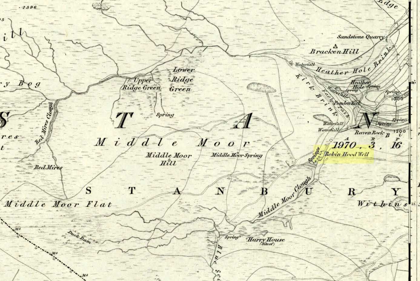
Follow the same directions to get to the nearby Ponden Kirk and, once on top of the rocks, overlooking the valley, walk on the footpath to your right. It bends round and follows the stream up onto the moors. About 100 yards along, walk up the heathery slope to the right and you’ll find several boggy watering holes on the top of the ridge. In looking at the first OS-map of the area in 1853, it seems that the northernmost of six boggy springs is the Robin Hood’s Well – although we don’t know this for certain. It’s one of them though!
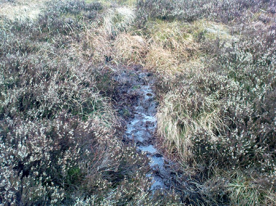
Archaeology & History
Robin Hood’s Spring, above Ponden Kirk
There’s little to see here really: it’s little more than a small boggy spring of water emerging from the edge of the ridge, as the photo shows. Curiously, descriptions of the site (and its neighbouring compatriots, Will Scarlett’s Well and Little John’s Well) are sparse aswell. It was noted by the Ordnance Survey lads in 1848 and subsequently posted on the first OS-map of the area in 1851. Both Horsfall Turner (1879) and Johnnie Gray (1891) mention the site passing, saying nothing of the place. However, several years after Gray’s work, Halliwell Sutcliffe (1899) ventured here and gave us the first real description of the place, telling:
“Half-hidden underground, and fringed with fern and bog-weed, lie the three wells which go by the names of Robin Hood, Little John and Will Scarlett. One may stop to ask how they came by their birth-names, to wonder why a man should have troubled to fashion them in this out-of-the-way spot; but neither speculation nor questioning of the moor folk brings one nearer to an answer.”
Folklore
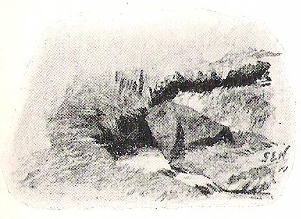
Halliwell Sutcliffe’s scruffy quick sketch, circa 1898
Apart from this site being a spot where the legendary outlaw stopped and drank in ages past, the healing attributes of these waters have long since been forgotten. Considering the proximity of the Ponden Kirk and its legendary association with fertility and marriage rites, I’d guess that such lore wold have centred around Beltane, or Mayday; and Robin Hood is very well known in folklore to have close associations with the same period. So — and I’m guessing here — it’s likely that whatever might have occurred at this well, would have taken place around Beltane aswell.
References:
Gray, Johnnie, Through Airedale from Goole to Malham, Walker & Laycock: Leeds 1891.
Sutcliffe, Halliwell, By Moor and Fell in West Yorkshire, T. Fisher Unwin: London 1899.
Turner, J. Horsfall, Haworth, Past and Present, Hendon Mill: Nelson 1879.
")