From Askwith village go up the Moor Lane and at the crossroads go straight across (Snowden Moor is to your left). Go down and along Snowden Carr Road until the road levels out and, watch carefully, about 500 yards on from the crossroads on your left you’ll see a small crag of rocks in the fields above. Stop and go through the gate walking up the field. At the top is a gate: go thru this and turn right, up the footpath for 100 yards, keeping your eyes peeled! You’re damn close!
Archaeology & History
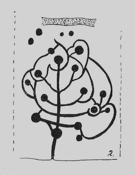
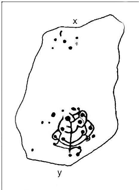
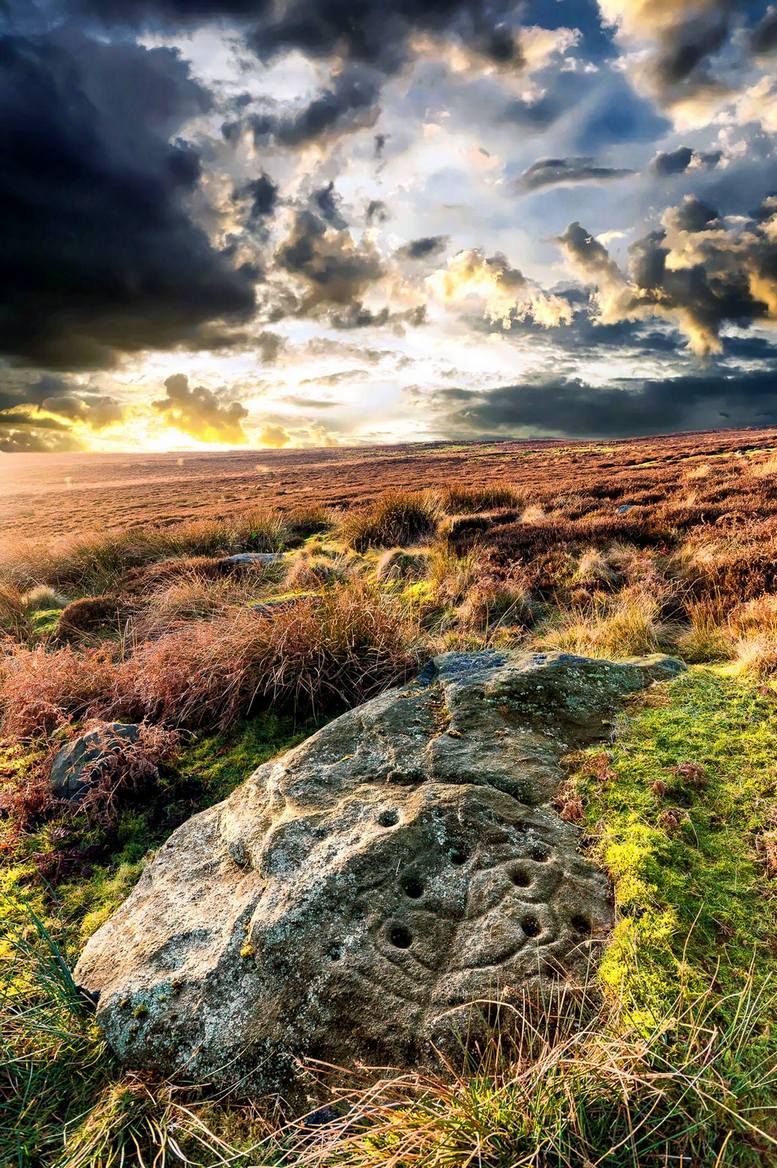
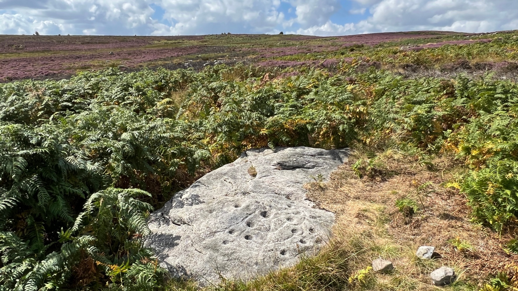
The most well-known and one of the more decorative of all the carvings in and around the Snowden Moor region is the Tree of Life Stone. In the 1930s, Eric Cowling first reported how, “this fine marking is the only one which appears to be known to the people of the district,” due in part to it being a site of local social activities (though nothing is said of this place in William Grainge’s [1895] survey). Cowling (1937) described the carving thus:
close-up of main featuresEric Cowling’s sketch
“This stone lies alongside the bridle path which skirts the southwest corner of the enclosed moorland above the hamlet of Low Snowden. A large flat rock surface at ground level has a number of cups joined together by a series of curved grooves, which in their turn are connected to a central straight groove. Immediately above the design, a broad groove has been cut across a raised central area as though to isolate the markings from several scattered cups which are to be found on the remaining surface.”
The modern surveyors Boughey & Vickerman (2003) tell us that this highly ornate stone comprises of,
“about 25 cups, with a group at the highest…end and a few isolated, but most in complex design with enclosing grooves suggesting a tree in fruit: hence the name ‘Tree of Life Rock.'”
The Tree of Life StoneBoughey & Vickerman’s sketch
The Coped Stone carving is just a few yards away and, on the slopes below here — as well as on the moor stretching above you — there is an excess of prehistoric remains: enclosures, hut circles, lengths of walling, cairns, other cup-and-ring stones — the vast majority of which has yet to be excavated in any formal sense (are any rich doods out there reading this who might wanna get things going…?). It appears that both the Coped Stone and the Tree of Life carving may have been linked by some ancient walling that appears to run between them.
Another possible variant on the Tree of Life Stone has recently been uncovered on the outskirts of Ilkley; but on this newly-discovered example we find the central ‘trunk’ of the ‘tree’ is a natural crack that runs up the middle of the rock. Up the ‘trunk’ are several short branches with cup-marks on either side, not unlike apples on a tree. Altogether there are at least 12 cups and one ring, with several curious lines, some of which seem geophysical in nature. After several visits to the site, it’s obvious that the ‘tree’ design is more obvious and there are additional faint carved sections on the stone which weren’t visible when it was discovered in heavy rain and poor light.
This is one of very few cup-and-ring stones with folklore attached. Cowling (1937; 1946) reported it to be site of early morning Beltane (May 1) gatherings. The title of the stone, the Tree of Life, was one he heard local people call this site, but “no reason is offered”, he said. About 100 yards below this we find a curious erectile, fertility image on the impressive carving 612, which (he says tenuously!) may (and that’s a dodgy “may”!) relate to the Beltane rites at the Tree of Life.
Tree of Life in situ
In more modern folklore, the old earth mysteries writer Guy Ragland Phillips (1976) suggested the Tree of Life Stone to be an important focal point along one helluva highly speculative ley line: running from the Irish Sea, across land and the Tree of Life stone, continuing way east until hitting the North Sea! If this old ley did have any validity (it doesn’t!), the Tree of Life’s carved partners east and west of here — the Coped Stone and carving no.597 — would have also been on the same line.
References:
Boughey, Keith & Vickerman, E.A., Prehistoric Rock Art of the West Riding, WYAS 2003.
Cowling, Eric T., “Cup and Ring Markings to the North of Otley,” in Yorkshire Archaeological Journal, part 131, 33:3, 1937.
Cowling, Eric T., Rombald’s Way: A Prehistory of Mid-Wharfedale, William Walker: Otley 1946.
Phillips, Guy Ragland, Brigantia — A Mysteriography, RKP: London 1976.
Acknowledgements: Many thanks to James Elkington and to Yorkshire Daz for use of their photos.
Not too difficult to locate if you don’t mind wandering to and fro in deep heather. From the Askwith Moor Road parking spot, walk up the road (north) 300 yards until you see the disused quarry on the moor to your right. From here, head onto the moor, straight down past the quarry for about 200 yards, angling slightly to your right. You’ll notice some overgrown ‘lumps’ in the heather — deemed as a cairnfield by archaeologists — go just below these and watch out for some rocks emerging from the heather. This carving (and its neighbours) is on one of ’em!
Archaeology & History
This curiously-shaped large rock has several worn cup-and-rings on its upper surface, with several cup-marks aswell. Two deeply etched lines running down the edge of the rock have also been pecked away as part of the carving, in contrast to the distinguishing natural water-worn line that runs diagonally along and down to the bottom of the stone.
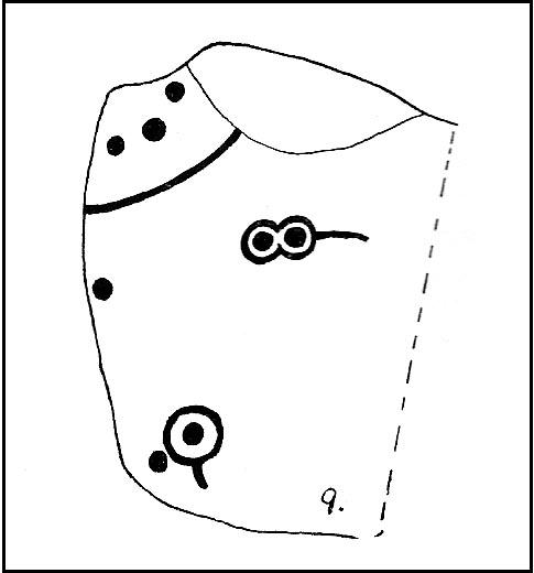
The site was first described by Eric Cowling (1937), who labelled it as Carving no.9 in his survey, saying:
Carving 582, looking SWCarving from above
“At the eastern and lower end of the barrow group on Snowden Carr is a cluster of angular boulders, one of which has several markings cut on the upper surface. There is a cup and ring on the highest, and alongside two rings are joined together and enclose separate cups. One corner of the area is isolated by a groove running from edge to edge, and within this enclosure are three cups.”
Catalogued as ‘stone 582’ in Boughey & Vickerman’s (2003) survey, their description of the carving was one with “fourteen possible cups, several with indications of a ring, some of which intersect; grooves.”
References:
Boughey, Keith & Vickerman, E.A., Prehistoric Rock Art of the West Riding, WYAS 2003.
Cowling, Eric T., “Cup and Ring Markings to the North of Otley,” in Yorkshire Archaeological Journal, part 131, 33:3, 1937.
Cowling, Eric T., Rombald’s Way: A Prehistory of Mid-Wharfedale, William Walker: Otley 1946.
From the Askwith Moor car-park, walk down the road (south) for 2-300 yards until you reach the gate on the right-hand side of the road. Go thru this and turn immediately left, following the fence along, parallel to the road for about 100 yards (if you reach the small disused quarry, you’ve gone 100 yards too far), then walk into the heath, up near the top of the little peak and walk down the other side of the slope for about 80 yards. You’re getting damn close — look around!
Archaeology & History
First found on the afternoon of May 13, 2010, in the company of Dave Hazell — though at the time the light was poor and the sky was grey and overcast, not allowing for any decent images being made. We returned here yesterday under a lovely clear sky for most of the day (and without the polluting roars of planes from the nearby airport, thanks to that great Icelandic volcano [keep it going!], making it even better) and got some decent photos this time.
Sketch of basic designClose-up of some cups
It’s only a small low stone, slightly sloping (similar in size and form to carving no.535 about 100 yards west of here), and is gonna be very difficult to find when the heather is in full growth. But thankfully when we found it last week, the heather had been burnt back. Whilst there are two large and very notable cups here — one on the west-facing vertical edge of the stone, the other on its south-facing slope — several others are more troublesome to see clearly, both through a mixture of age and erosion. The other cups are a little smaller aswell, being very similar in status to the curious small cup-markings on the Lattice Stone carving (no.481). One cluster of these smaller cups are arranged in a curved T-shape formation around the middle to eastern-side of the rock. Below this are what seems to be a long singular cup, but upon feeling this — the Beckensall technique — the hardworking Keighley volunteer Michala Potts found it seemed to consist of three small cups all linked to each other. Attached to this section, a small groove runs up to the aforementioned T-formation cluster. Whilst at the top-end of the stone is what seems to be another larger cup-marking, but I’m not sure whether it’s Nature’s handiwork, or artificial. A few more visits here might enable us to say one way or the other!
There are no other archaeological remains immediately adjacent. Another “possible” cup-marked rock (more than twice the size of this stone) can be found about 30 yards further uphill, next to another large stone. But one of the nice things about this small carving is its position in the landscape: an excellent view opens up of mid-Wharfedale below you, and the uphills of Rombald’s Moor is on the far side of the valley. Make of it what you will…
References:
Boughey, Keith & Vickerman, E.A., Prehistoric Rock Art of the West Riding, WYAS 2003.
From Shipley Glen, walk up to the Dobrudden caravan park on the western side pof Baildon Hill and then in the long grasses immediately north of here, on the Low Plain, this old carving could once be found. I’m told it’s been moved in recent years (but have a mooch round anyway – there’s a number of other old cup-and-rings in the locale).
Archaeology & History
This small carving is not in its original position, having been moved to where it now sits a short distance northeast of the Dobrudden caravan park. It was first described briefly in Mr Baildon’s magnum opus here, seemingly omitted from the Hedges (1986) and reclassified as ‘stone 169’ by Boughey & Vickerman (2003). I’m not 100% certain that the illustration here by Joseph Rycroft and carving no.169 are one and the same – but they seem incredibly alike. If anyone knows for sure, one way or the other, please lemme know and I’ll amend as necessary!
References:
Baildon, W. Paley, Baildon and the Baildons – part 7, Adelphi Press: London 1913.
Boughey, Keith & Vickerman, E.A., Prehistoric Rock Art of the West Riding, WYAS 2003.
Hedges, John (ed.), The Carved Rocks on Rombalds Moor, WYMCC: Wakefield 1986.
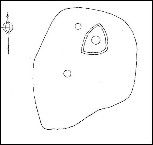
C.F. Forshaw (1908) told us that “this Castlestead…lies on the high ground between Cullingworth and Denholme, about 300 yards east of the point where te Cullingworth Road meets the Halifax-Keighley Road in Manywells Height, and over looks Buck Park Woods and the beck flowing down a deep ravine to enter the head of Hewenden Reservoir. A little to the north lies Moat Hill Farm…and the ancient burial place therewith associated.” Very little remains of the site can be seen.
Archaeology & History
C.F. Forshaw’s 1908 plan of this Castle Stead site
Just over a mile southeast of the site of (virtually) the same name — the Castlestead Ring — this here Castle Stead site had me thinking that both sites were one and the same (poor research on my behalf I’m afraid). At the moment, the archaeological period of when this site was constructed remains unknown. Thought by Forshaw (1908) to be “almost certainly a hitherto unknown Roman entrenchment,” the very slight remains left here could be Iron Age or Romano-British. In his lengthy article on the remains that could be seen here more than 100 years ago, Mr Forshaw told us:
“Several fields hereabouts bear the name Castlestead and one of these contains the entrenchment, which almost coincides within its area… The reason for the selection of this site is clear, for on no side is it commanded by higher ground: whilst one face has a natural fortification of a rock scar impassable at most points and easily accessible at none. Here very little art would make the position impregnable in primitive warfare, and it is noticeable that the most suitable part of the verge has been selected, and almost the whole of the scar has been included. It is, however, only right to state that stone has been quarried here within living memory and this may have altered the ground considerably, and may account for several features mentioned hereafter.
“The accompanying plan (above) will make the outline of the fortification clear, and from it one can readily recognise the usual Roman form. The moat and bank, the quadrangular shape with rounded corners and the entrances on three sides (and possibly on the fourth also) are characteristic. The unusual point is the selection of a natural fortification for one (the south) side.
“The question at once arises: was this a permanent stone fort? Clearly not, for the bank has been cut across at four places (A, D, H & L) and not only was no stone found — beyond such odds and ends as may be seen in any field — but the deeper, undisturbed layers of silt showed no signs of a trench in which foundations might have stood. It is noticeable that there are more stones on the crown of the bank than elsewhere. This I take to be the remains of what was thrown up in the bank. The field has been cultivated many years, so that the bank has been much reduced in height and the moat filled up.
“The original height of the bank is difficult to guess, but the moat was about three feet deeper than at present at the point H, and from the amount of soil removed we may imagine the bank about five feet higher than it is now, and solid at that; this makes a total outside slope of about 10 feet, a very formidable obstacle to surmount in the face of opposition, especially is strengthened by a stockade, such as was possibly present.The remains of the bank are capped with a layer of some six inches of bluish, silty clay. This was evidently placed there deliberately, and is in accordance with Roman work as seen elsewhere (e.g., at Castleshaw, near Oldham). There is also some slight evidence that, as at Castleshaw, the moat was once faced with irregular pieces of flat stone. The moat was some 18 feet across at the top, six feet at the bottom and five feet deep. The east and west sides were probably less strongly entrenched. Certainly the moat was much less, for rock lies only just below the sod, halfway along the western side. When the southern face is examined there are more signs of stonework, however, for where the rock is deficient the gap is filled with the remains of a dry wall which has some peculiar characteristics. In places the lower part of this wall is formed of roughly-shaped oblong blocks of large size (one has a face of 57 x 17 inches), arranged in definite tiers. This is not like an ordinary field fence, and differs even more from the ancient wall marked (probably erroneously) as Denholme Park Wall on the Ordnance map, which it continues: so it is conceivable that it may be Roman work. There is now little or no sign of a bank along the rocks bounding the southern side of the camp, but it is probable that something once existed to give cover to the defenders, and we may well imagine a low dry wall continuous with the fragments just described: and it is rather noticeable that there are more squared stones in the walls of this field than in others in the neighbourhood.
“There are no traces of buildings within the lines so far as the present investigations go, nor signs of prolonged occupation at the site. I have dug at the points indicated (on the map above) and came upon rock or disturbed silt in each case. The circular shallow hollow in the centre seems natural. It is to be remarked that the average depth of surface soil in this field is unusual, more than one foot in fact.”
Mr Forshaw then goes on to ask a series of questions, followed by his own particular answers and theory relating to the nature of these earthworks. Hopefully you won’t mind if I cite his ideas in full, despite him thinking that the remains here are of Roman origin (remains of which I don’t really wanna include on TNA). He continued:
“Was this camp on the course of a Roman road? One can only say that no definite road exists at the entrances now, but there seems some ground for thinking that a surface was prepared…at the western entrance for two reasons:
1. Just to the north the rock is covered with made soil only; but in the entrance itself irregular stones are packed in a level, solid manner, giving a strong impression of artificiality. At the southern verge of the entrance this layer ends abruptly in a line at right angles to the bank, and here it is based not on rock, but on natural silt.
2. A slight hollow runs straight westward from it for some twenty yards through the next field. This may represent a destroyed road.”
Mr Forshaw then makes a few attempts to justify this idea, including notices of footpaths and linear features near the site, aswell as citing earlier historical sources that describe Roman roads — but the ones cited are some considerable distance from this site. In summing up, he notes how no Roman finds were made here — nor indeed any finds from earlier periods — but he opted for the site being a temporary Roman outpost. The more recent opinions of this place are that it was of late Iron Age or Romano-British origin.
References:
Cudworth, William, Round about Bradford, Thomas Brear: Bradford 1876.
Forshaw, C.F., ‘Castlestead, near Cullingworth,’ in Yorkshire Notes and Queries – volume 4, H.C. Derwent: Bradford 1908.
Hindley, Reg, Oxenhope: The Making of a Pennine Community, Amadeus: Cleckheaton 2004.
James, John, The History and Topography of Bradford, Longmans: London 1876.
Keighley, J.J., ‘The Prehistoric Period,’ in Faull & Moorhouse’s, West Yorkshire: An Archaeological Survey to AD 1500 – volume 1, WYMCC: Wakefield 1981.
Varley, Raymond, “The Excavation of Castle Stead at Manywells Height, near Cullingworth, West Yorkshire,” in Transactions of the Hunter Archaeological Society, volume 19, 1997.
Cup-and-Ring Stone: OS Grid Reference – NZ 0774 7048
Archaeology & History
1928 photo of carving
Found inside a prehistoric tomb that was excavated in the late 1920s “by Messrs R.C. and W.P. Hedley at Pike Hill, near Stamfordham,” this fascinating-looking carving was found on a stone that “was overlying the primary burial” cist in the middle of the tumulus, measuring “2 feet 9 inches long by 2 feet wide and 12 inches deep, with an orientation on the longer axis of NE.” As we can see in the old photo that accompanied Mr Hedley’s (1928) short article in Antiquity journal, four single cups are arranged in a rough square and are joined with each other by a single line, running from cup to cup, outlining a clear quadrilateral formation. Two other single cups are outliers on the left and right side of the ‘square.’
A second smaller cist was also found inside the same mound and on the central inner face of this was another, more simplistic carving described as “a very fine cup-mark 1½ inch in diameter and ¾-inch deep.” These carvings are no longer in situ (I think they’re in Newcastle Museum) and apparently this second single cup-marked stone can no longer be located.
References:
Beckensall, Stan, Northumberland’s Prehistoric Rock Carvings, Pendulum: Rothbury 1983.
Beckensall, Stan, Prehistoric Rock Motifs of Northumberland – volume 2: Beanley to the Tyne, Abbey Press: Hexham 1992.
Hedley, R. Cecil, “Ancient British Burials, Northumberland,” in Antiquity Journal, volume 2, December 1928.
This large cup-marked stone was known by local people as the Clach na Sithean, or the stone of the fairies. Its smooth surface and well-cut grooves was said to be due to the fairies sharpening their knives upon it, and the straight cuts or grooves were tests of the keenness of their blades.
In addition to the fairies having hold over this stone, a brownie creature also roamed between here and the burn of Allt Mor. Although a dutiful creature, he commonly used to scare the women when they returned from the ceilidhs by chasing them and screaming a curious noise at them. But as well as this, he would also enter the local houses and farms after nightfall and, when the local folk were asleep, would clean the supper dishes and put them in their rightful places. But if there was no work to be done once he had entered their homes, he would take the dishes out and place them on the floors where they would be found in the morning by perplexed householders. Then they’d know that the brownie had visited. Sometimes he was a great help to the housewives, other times a nuisance. He became known to local people as Puddlefoot, or Cas an Lubain, but so offended was he by the name when he heard it, that he let out an almighty scream and vanished, never to be seen again.
References:
Kennedy, James, Folklore and Reminiscences of Strathtay and Grandtully, Munro Press: Perth 1927.
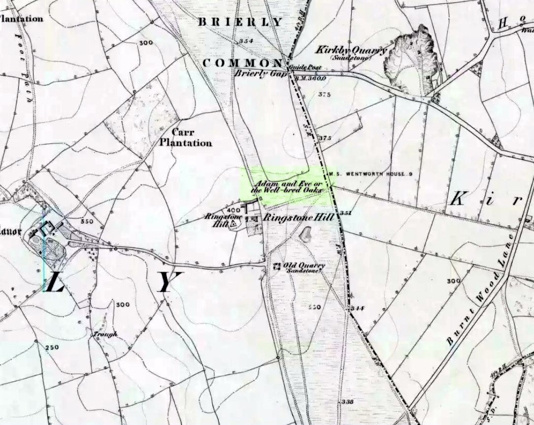
Highlighted on the 1854 Ordnance Survey map close to the township boundary line as Adam & Eve’s Oak, between Brierley and South Kirkby, I can’t find too much about this once great tree. However the Wakefield historian W.S. Banks (1871) told us the following:
“Upon the common at Ringston Hill grows the remarkable ‘old Adam’ oak, much decreased in size in late years. It is an ancient and large tree measuring twenty-seven feet in girth at a yard above the ground. The trunk is hollow and the north side is broken away. Most of the branches are also gone. In 1868 a very large branch was blown off by the wind; but on the southerly side are still some very vigorous limbs.”
The old oak on the 1854 map
Even when Banks wrote this he said how the tree “must be many centuries old.” In the time of King Charles II there used to be an old inn by Adam’s Oak at the foot of Ringston Hill, where the famous highwayman, Nevison (much-loved by many Yorkshire-folk because of his Robin-Hood-like character), used to stay. The inn was owned by one Adam Hawksworth, but was ordered “to have his sign taken down for harbouring Nevison.”
Folklore
W.S. Banks also wrote of this once great tree:
“The people at Brierley tell of Nevison the highwayman lodging in it and hiding stolen treasures in it, things which probably did not happen, though Nevison’s name is connected with Ringston Hill.”
The treasure legend may have more to do with the adjacent stone circle, as we find ‘treasure’ a common motif at such places.
References:
Banks, W.S., Walks in Yorkshire: Wakefield and its Neighbourhood, Longmans, Green Co.: London 1871.
Various ways here. From Keighley, go up the Halifax Road, first left after the Ingrow West train station, uphill, then up the long zizaggy road till you hit the pub at the crossroads. Park up and walk along the road in front of the pub for 1-200 yards and look at the hill above you! Alternatively, from Bingley go up to Harden on the B6429 and literally just where the village ends, there’s a small right-turn (if you’re going past the fields on either side, you’ve just missed the turning!). Go up there till the road reaches the top and stop! Catstones Hill is in the heather over the wall on your left!
Archaeology & History
A somewhat anomalous earthwork site, with lots of archaeohistorical speculation behind it, but no firm conclusion as to its precise nature as yet. Defined variously as an earthwork, an enclosure (for both people and cattle!) and a settlement by respective archaeologists over the years, there is little to be seen of the place on the ground and it doesn’t tend to bring raptures of delight to the common antiquarian. When William Keighley (1858) described this place, Catstones Ring was,
“enclosed on three sides by a considerable bank of earth, and bears evident marks of the plough. The country people believe it to have been an intrenchment or camp.”
Mrs Ella Armitage (1905) thought this site may have been “a prehistoric fort,” but said little more about it. In the same year however, Mr Butler Wood (1905) gave us a much better account of the place, describing Catstones Ring as “the most striking earthwork in the neighbourhood of Bradford.” His broader description told that:
“It encloses the crest and slope of a hill, and measures 266 yards on the east side (which is perfect), and 100 yards on the north side; the latter, however, being traceable at least 100 yards further across cultivated fields. The south side is almost obliterated by quarries, while the western portion has disappeared altogether. The fosse which surrounded this fine fortification is still visible on the eastern side.”
A couple of years later two short notes were made of the site in Forshaw’s Yorkshire Notes and Queries. Peter Craik (1907) of Keighley described the dimensions of the main ring as being “110 x 320 yards (rough guess),” and he also described finding the remains of a cairn in the outer dyke section (marked as ‘X’ on Craik’s diagram, below). On the nature of the site, he wrote:
“Catstones would appear to have been built as a defence against invasion from the south, for in contrast to the early defensible approach from that direction is the fact that to the north lies the undulating expanse of Harden Moor, which for the most part is on a level with the ring, even the highest point in the immediate vicinity being without the main circle, though enclosed in a minor outwork. The large extent of the ring makes it rather difficult to believe that enough men could be collected in the immediate neighbourhood to man the lines satisfactorily; and again as a shelter for cattle, etc, in time of war it does not appear to be well designed, for most of the interior would be commanded within easy range of arrows. Certain old excavations exist within the ring; probably they were made in search of gravel or some such material, but is this conjecture certain? Can they possibly mark the site of dwellings?”
J.J. Brigg (1907) followed up Craik’s short piece with the suggestion that the site was Roman in origin, saying:
“In showing the 6in map to Professor Bosanquet of Liverpool…he said there was no reason why it should not be Roman, merely because there is no masonry. The Roman legions went into laager* every night, and it is quite possible that some very large body of soldiers halting there for the night might have thrown up an earthwork and planted thereon the stakes which they always carried with them for that purpose.”
But I think this is most unlikely. Very little has been found here to give us a better idea of dates and function; and in a limited excavation here in 1962, no artifacts of any kind were located. A little more recently, J.J. Keighley (1981) has suggested the site to be Iron Age in date, describing it as one of the most impressive sites of its kind in the region. The Catstones Ring is “a 6.5 hectare quadrangular ditched enclosure,” he wrote, which he thought had been much destroyed by the adjacent quarrying.
“Aerial photographs taken by the County Archaeology Unit in 1977 however, shows that the southeastern corner of the enclosure and parts of its southern ditch survived the quarrying. Villy (1921) observed an outwork to the north of the main enclosure, which was visible on aerial photographs taken in 1948, and the 1977 aerial photographs…show a possible annexe attached to the outside of the northeastern corner of the main enclosure.”
P. Craik’s 1907 drawing
This extended section of Catstones’ main earthworks were, in fact, first described in the article by Peter Craik (1907), as shown in the hand-drawn plan of the site here. And in all honesty, virtually nowt’s been done since these early antiquarians diggings and essays. The information from the present day Sites and Monuments Record says that the site is a “late prehistoric enclosed settlement” and that quarrying has destroyed much of the west side.
Folklore
Harry Speight (1892) reported the earthworks here to have been a site where a great battle once took place, between the local people and the early Scottish tribes.
References:
Armitage, E., ‘The Non-Sepulchral Earthworks of Yorkshire,’ in Bradford Antiquary, New Series 2, 1905.
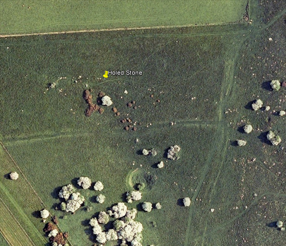
Follow the same directions as if you’re visiting the Polisher Stone at the top-end of Overton Down where it meets Fyfield Down. From here, walk down the slope for a hundred yards or so where you’ll notice, just above the long grassy level, a line of ancient walling running nearly east to west. It’s very close to the yellow marker in the attached aerial image shot to the right. If you walk along this line of walling you’ll find what you’re looking for.
Archaeology & History
Overton’s Holed Stone
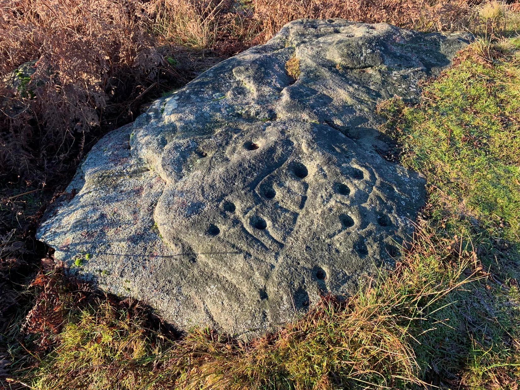
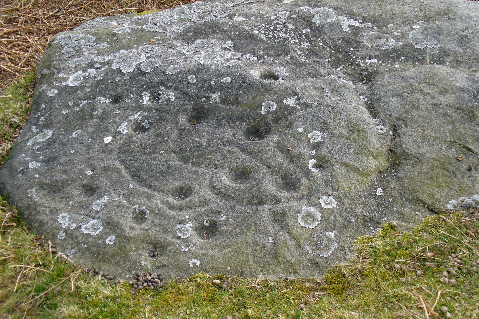
As I’ve only been here once, and briefly — under the guidance of the Avebury expert Pete Glastonbury — my bearings on this site may need revising. There are two distinct sections of walling here: one has been excavated by Peter Fowler and his team; the other hasn’t. (correct me if I’m wrong Pete) And in Fowler’s (2000) fine survey of this area he does not describe this very distinct holed-stone in the line of walling, or adjacent “linear ditch F4”, as it was called. But then, many archaeologists don’t tend to find items such as these of any interest (unless their education stretches to other arenas, which isn’t usually the case). But the stone seems to be in a section of walling that isn’t in their survey; standing out in aerial imagery as a less well-defined, but still obvious line of walling that is closer to the fence, 70-80 yards north, with a decidedly Iron-Age look about it!
But, precision aside! — as you can see in the photos, the holed stone here isn’t very tall — less than 2 feet high; though we don’t know how deep the stone is set into the ground. This spot is on my “must visit again” list for the next time we’re down here!
There’s nowt specific to this stone, nor line of walling, nor settlement (as far as I know), but it seems right to mention the fact that in British and European folklore and peasant traditions, that holed stones just like the one found here have always been imbued with aspects of fertility — for obvious reasons. Others like this have also acquired portentous abilities; whilst others have become places where deeds and bonds were struck, with the stone playing ‘witness’ to promises made.
References:
Fowler, Peter, Landscape Plotted and Pierced: Landscape History and Local Archaeology in Fyfield and Overton, Wiltshire, Society of Antiquaries: London 2000.


")