From Bainbridge, take the A684 road east to Aysgarth. Just out of the town, 200 yards over the bridge, take the right turn down Blean Lane. Nearly ½-mile along, take the minor road on your left and go along here for 1½ miles where, a few hundred yards before the solitary farm of Carpley Green (lucky buggers!), you can park up. (keep plenty of room for a tractor to get in the fields) Walk down the track past the farm and 250 yards along, where the first field ends, a gate leads you into the hills on your left. Go through here and then the next gate 120 yards on, then walk straight along th elong geological ridge ahead of you, veering to the top-side until it meets the walling. You’ll see the giant Stoney Raise cairn on the other side.
Archaeology & History
Stony Raise from above
The remains we find here are nigh-on immense! If giant cairns get you going (like the Great Skirtful of Stones or the denuded Devil’s Apronful near Pendle, etc), this one will blow you away! Along its widest axis, to this day it’s nearly 40 yards across and nearly 7 feet high! But in earlier times it was even bigger—much bigger! The first known description of the site was made by one Charles Fothergill, a Yorkshire-born politician and ornithologist, who wrote a diary of his walking excursions to various places in North Yorkshire at the beginning of the 19th century. (Romney 1984) His account of it was a good one for that period and thankfully he recorded information that would otherwise have been forgotten. After his visit here in September 1805, he told about this,
“wonderful tumulus called Stone raise which is a great curiosity: it is formed entirely of large stones piled up without earth or gravel, differing in that respect from any I have seen. Notwithstanding that upwards of a thousand, nay ’tis said several thousand, loads of stones have been led away from it to build walls with, it yet remains a stupendous monument of this species of antiquity: we measured the base of it as well as we could by our strides and made it 369 feet in circumference and of such an height as to be seen for a considerable distance. It has been most completely rifled…and it now presents a number of small craters formed by the investigations of the money searchers. It is situated upon a hill about half a mile south of Addlebrough. In addition to the particulars I formerly mentioned, I may say the men who first opened it about 50 years ago worked incessantly for 33 days. It stands on Thornton moor, and tho’ the Thornton men would not assist in the labour, they intended to share in the profit if there was any; but the adventurers who had all the work resolved they should not and they carried a large sword with them every day to defend the treasure in case they found any; the wise man who read ’till the stones shook and rattled was a schoolmaster at Bainbridge: the teeth they found were deposited in a hollow place in the bottom of the tumuli formed long and narrow like a coffin by a walling of stones. Tho’ the tumulus has apparantly been compleatly rifled, I do not believe the whole base has been sufficiently searched, but if it was to commemorate one great individual, which appears to have been the case, perhaps nothing more may be found.”
Fothergill’s description of “upwards of a thousand” cartloads of stone being removed from Stony Raise has been doubted by some archaeologists, but this claim should not be dismissed so lightly without evidence. There are immense tombs from northern Scotland to the unholy South that have remained untouched by the hand of industrialists that easily enter the category of such giants and this may have had equal stature.
A few years after Fothergill’s visit, Thomas Whitaker (1823) briefly described the site in his magnum opus, but added very little, simply telling that on the hills behind Addlebrough,
“there is still on that elevated spot a cairn, called Stone Raise, about 120 yards in circumference at the base, to which the usual tradition of its containing a treasure of gold having been attached, two persons were several years ago induced to make the experiment; but having penetrated to the centre, found, to their great disappointment, what an antiquary would have prepared them to expect, namely, a kist vaen of flag stones, with the remains of a human skeleton, the teeth of which were still pretty perfect.”
To this day the site remains unexcavated, so we don’t know too much about the place. It’s likely to have been constructed in neolithic times and its ancestral nature quite obviously venerated. It may have been re-used during the Bronze Age, but without excavations we may never know. A decent dig into this site is long overdue!
Folklore
This gigantic tomb is, not surprisingly, said to be haunted. Strange sounds and visions have been encountered here in bygone times. But the most well-known tale is that it was the site of a great treasure—perhaps hinted at by Fothergill. There are variations on the theme, but this is overall story:
Structured stonework
The tomb was said to be where a local giant had fallen and with him was buried a great chest of gold which he had dropped before he died. Some say that the ‘giant’ was a Brigantian chief – others a great warrior. The great treasure chest beneath the cairn is said to be looked over by a fairy who once lived by the giant’s tomb. It was this tale which gave the site its local name, the ‘Golden Chest on Greenber’. Several attempts have been made to find the treasure, but all have failed.
However, when the roving antiquarian Edmund Bogg came to write of the place in 1908, the giant had by all accounts been found within! He told us that,
The giant’s cist cover?
“this Kist-vaen was opened, many years back, and the skeleton of a chieftain of great stature was unearthed; the treasure chest of that or some other primal savage was not, and has not yet been discovered – for, take heed ye matter-of-fact money hunters, it is said the lucky one must first see the wraith of the ancient warrior to whom it belonged, who will then shew under which part of the immense Raise it is hidden! May this help any reader who is imaginative enough to find it – having seen the wraith he must keep silence – he has then but to stretch out his hand, and draw it forth.”
There are variations on this tale that have subsequently been penned by a number of Yorkshire folklorists, but this is the general lore. There was also a short rhyme told of Stoney Raise, that speaks of its apparent use through history by various races:
Druid, Roman, Scandinavia,
Stone Raise in Addlebro’.
References:
Bogg, Edmund, Wensleydale and the Lower Vale of the Yore, E. Bogg: Leeds 1906.
Bogg, Edmund, Richmondshire, James Miles: Leeds 1908.
Elgee, F. & H.W., The Archaeology of Yorkshire, Methuen: London 1933.
Gutch, Mrs E., Examples of Printed Folklore Concerning the North Riding of Yorkshire, David Nutt: London 1899.
Lofthouse, Jessica, Countrygoer in the Dales, Hale: London 1964.
Parkinson, Thomas, Yorkshire Legends and Traditions – volume 2, Elliot Stock: London 1889.
Pontefract, Ella, Wensleysdale, J.M. Dent: London 1936.
Romney, Paul (ed.), The Diary of Charles Fothergill, 1805, Yorkshire Archaeological Society: Leeds 1984.
Whitaker, Thomas Dunham, An History of Richmondshire – volume 1, Longman Hurst: London 1823.
White, Robert, A Landscape through Time, Great Northern: Ilkley 2002.
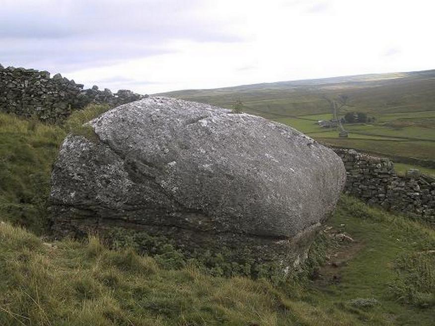
From the small town of Bainbridge, head south down the Carpley Green Road. Less than a mile before the end, look to the west-facing slope of Addlebrough Hill and this huge Devil’s Stone can be seen resting halfway up the slope, just by the wall. Y’ can’t miss it!
Archaeology & History
The Devil’s Stone
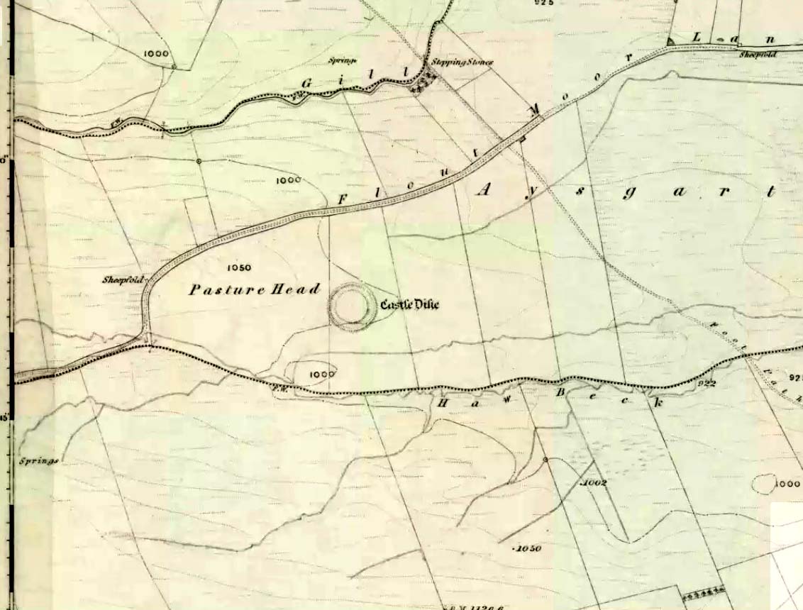
Highlighted on the 1856 Ordnance Survey map, one of the legends of this place suggested there might be cup-and-ring markings on the stone, but the curious markings on top of the rock seem to be natural. It’s a superb stone though, dropped here no doubt by some great glacier as it retreated north, in ages truly olde…
There’s a lot of archaeology around here that’s yet to receive the attention of the archaeology textbooks. But if you’ve ventured to see this, have a gander across to the massive prehistoric tomb known as Stony Raise, less than a mile southeast of here.
Folklore
One legend tells that long ago Addlebrough was the home of a great unnamed giant — but a friendly giant by all acounts. However, one day the devil turned up and wanted possession of the giant’s hill and so a fierce row broke out between them. Perched on the top of the crag — which is the rough ridge to the west of here — the giant who lived there hurled huge boulders down at the devil, but they fell short and landed at the side of Lake Semerwater (itself an important spot in local prehistory). In return, Old Nick himself began throwing boulders back — and one of those which the devil threw landed here, halfway up the western flank of Addlebrough Hill (a couple of the large boulders which the giant threw can be seen on the edge of Semerwater and are known as the Carlow and Mermaid stones). Hence it’s name of the Devil’s Stone!
In Edmund Bogg’s Richmondshire (1908), he told how, “the curious markings on (the Devil’s Stone) are accounted due to the pressure of the devil’s fingers” which were caused when he threw this giant stone from somewhere to here.
Site shown on 1856 map
This is a theme we find at countless other stone sites, i.e. the Devil burning holes into rock — and in some cases these devil’s “fingerprints” have turned out to be prehistoric cup-markings. Such tales relate to the pre-christian Creation Myth of a place and would, before the “devil” was supplanted onto a site, have had wider significance in the landscape as a whole, in a manner known only to local people. Devils usually replaced legendary giants, or the hero-figures who created the land in primordial times in the myths of our ancestors. A greater examination of the nearby sites in association with the folklore of the region would no doubt be quite profitable…
References:
Bogg, Edmund, Richmondshire, James Miles: Leeds 1908.
Romney, Paul (ed.), The Diary of Charles Fothergill, 1805, Yorkshire Archaeological Society: Leeds 1984.
Maypole (destroyed): OS Grid Reference – SE 0458 9121
Redmire’s ancient Oak
Archaeology & History
As with many of Britain’s old maypoles, the one at Redmire has long since disappeared and no local in the 20th century appears to have had any memory of it. However, it was mentioned in Victorian times and described in McGregor’s (1989) fine history work on the village:
“At one time, somewhere on the Green, stood a maypole which was destroyed by lightning. I never heard the memory of it recalled during my early life, but it is mentioned in their books by both Barker and Bogg. The remnants of it appear to have been there in 1850 or 1852, as Barker, writing at that time says, ‘A maypole, rare in Yorkshire, stands on the Green. It was shivered to pieces by the electric fluid, during a thunderstorm, in the summer of 1849. This poor maypoles catastrophe would have been regarded by the old Puritans as a direct and visible manifestation of the wrath of heaven at such a heathenish practice.’ Redmire, as we know, took pleasure in dancing in the 19th century, and continued to do so, especially after the building of the Town Hall…”
When Edmund Bogg came here at the end of th 19th century, he saw “the base of the ancient maypole…near to, a twisted and ancient oak” whose ancient branches were being held upright by large wooden posts. This sacred oak itself was said to “still cast its shade over a small spring of water.” Unfortunately I ‘ve found no more about this lost pagan relic…
References:
Barker, W.G.M.J., The Three Days of Wensleydale, Charles Dolman: London 1854.
Bogg, Edmund, Wensleydale and the Lower Vale of Yore, E. Bogg: Leeds n.d. (c.1900)
McGregor, Isabelle, Redmire – A Patchwork of its History, privately printed: Redmire 1989.
Go west through Aysgarth village along the A684 road and, just as you’re coming out of the town, take the left turn on the Thornton Rust road, past Town Head Farm, and turn left up the track (called Folly Lane). Go past the house where the track veers to your right and follow it straight on (don’t turn up the track on your left a short distance along). Keep walking on here for nearly a mile (about 10 mins), keeping your eyes peeled for the embanked rise in the field on your left, which is where the henge can be found! You’re damn close!
Archaeology & History
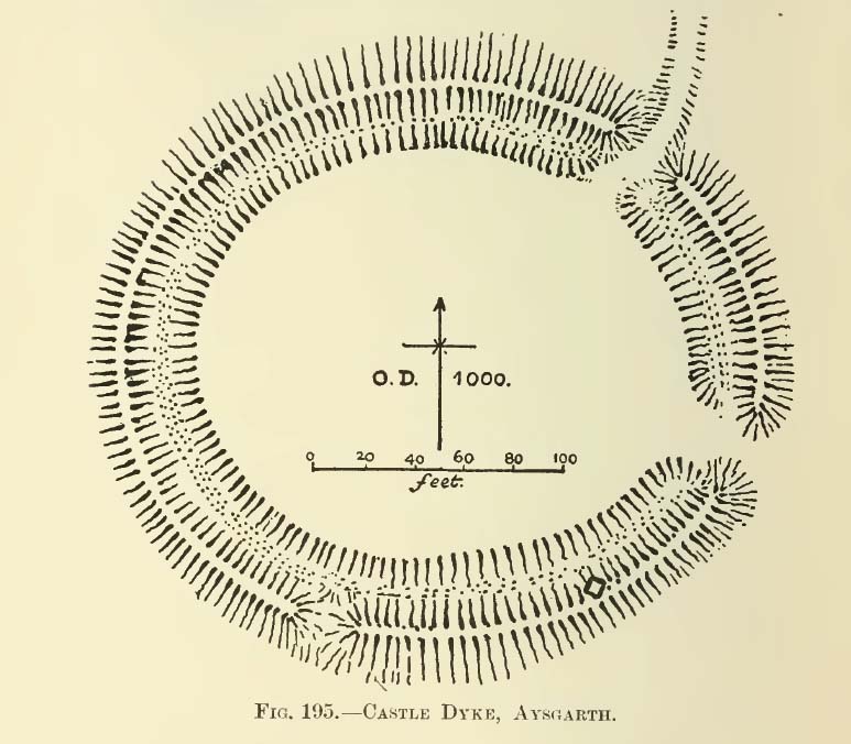
A.H. Allcroft’s 1908 plan
One of the earliest accounts I’ve found describing the Castle Dykes henge is in Mr Barker’s (1854) lovely literary exploration of Wensleydale, where he describes, “on Aysgarth Moor, which is now enclosed, may be seen a circular encampment, probably Danish” in origin. But he tells no more. When Edmund Bogg (c.1906) came here fifty years later, he added little extra, simply telling of, “the earthworks known as ‘Castle Dykes’, probably Angle or Danish, although Roman relics have been found here.” However, the brilliant Mr Speight (1897) gave what seems to be the earliest real description of the site when he described “the Celts” and the earliest settlers of the region, saying how:
“The so-called ‘Castle Dykes’ at Aysgarth betrays a probable connection with the same settlers. It is an irregular circular rampart, measuring about forty yards across its longest diameter, and not unlike the earthwork on Harkaside called ‘Maiden Castle’… A ditch completely encloses the mound, which, it should be noted, is unusually low, being little higher than the outer bank or upcast from the trench. It is totally different from the elaborate burh at Middleham; indeed, from its low and simply form, as well as from its situation in Celtic territory, there seems little doubt that it was the work of these early people.”
Ditch of Castle Dykes henge, looking east (photo credit – Richard Stroud)
Speight also made a suggestion that the place-name of Aysgarth itself may derive from this monument. He may have a point. A.H. Smith (1928) and other place-name authorities tell the name to derive from “an open space” either surrounded by, or — in some way — defined by oak trees. We might never know for sure…
Not long after the works of Speight and Bogg came the first real survey of British prehistoric earthworks by A.H. Allcroft (1908) — and amidst the mass of archaeological curiosities (as many were at the time) was another description of this great ceremonial monument. Allcroft told that here,
“a weak vallum of earth encloses a perfectly regular oval area measuring from crest to crest of the vallum 257 feet (east to west) by 217 feet (north to south). Immediately within the vallum is a broad fosse varying from 25 to 32 feet in width. The vallum at its highest (east) rises not more than seven feet above the floor of the fosse. The “island” measures 196 by 160 feet and is perfectly flat. There is no berm and no outer fosse. The vallum is broken by three gaps, of which that to the southeast is apparently original, as the fosse has never been excavated across it. The other gaps point respectively northeast and south-southwest, the latter being a mere depression like that to be seen at the eastern side of the northern ring at Thornborough. At one point in the vallum, on the southeast, a single large stone rises slightly above the turf which otherwise covers the whole work, and certain depressions observable at other points suggest that other such blocks have been removed —that, in fact, it originally had a peristalith standing upon the vallum. The principal entrance looks towards Pen Hill…”
Around the same time, the early scientific discipline of astroarchaeology was taking root and in Sir Norman Lockyer’s Nature journal, the reverend J. Griffith (1908) explored the potential astronomical orientation of Aysgarth’s Castle Dykes, thinking that the main entrance to the site gave indications of an alignment towards either Alpha Centauri or Capella. Y’ never know…
Although many visitors and local people knew of Castle Dykes, it was pretty late before the site gained status as a henge monument. This happened following a visit here by the pedantic archaeologist R.J.C. Atkinson (1951) in September of 1948. Following his visit, Atkinson described the place, saying:
“It consists of an oval enclosure bounded by a well-preserved ditch and external bank, with an entrance on the East side. Two small gaps in the bank, without corresponding causeways across the ditch, were probably made in recent times to allow the escape downhill of the surface water which collects in the ditch. The dimensions in H. Allcroft’s plan are incorrect. The markedly oval shape is probably in part dictated by the situation, in order that as much as possible of the enclosed area should lie on the level ground topping the ridge. There is no sign of any stone structure in the central area, but the district abounds in stone walls, for which the site may have been robbed in the past.”
Aerial image
In more recent years, archaeologists have speculated that the site was a sacred site or meeting place, aswell as a site where trade occurred, particularly a place where axes were traded; but this latter idea is more due to the projection of a modern religious notion, of ‘The Market’ with little veracity in terms of the site’s function. This increasing imposition of ‘economics’ and ‘trade’ (see Brown 2008:44-6) as vital ingredients to this and other sites has little relevance outside of a simple epiphenomenalistic adjunct to magical and tribal exchanges. But such notions are outside of archaeological frameworks, so we shouldn’t be surprised at so prevalent an error.
But this place is damn impressive — though with the exception of Mr Griffith, one notable ingredient archaeologists seem to have forgotten about was the position of this site in the landscape. The views surrounding the henge are excellent, giving a 360° arena all round. If the monument once had a ring of stones around it, as Allcroft suggested, the views would still have been the same. A modern excavation here might prove worthwhile and, as a result, open up once again, the potential for further astronomical investigations with the many hills and notches along the living horizon. This site, whilst requiring analysis of it as a ‘specimen’, must also be placed in the context of the wider living environment which, to all early traditional cultures, were such important and integral ingredients.
We have also found some previously unrecorded prehistoric remains nearby which, hopefully, we’ll be able to explore a little more in 2011 and report here.
…to be continued…
References:
Allcroft, A. Hadrian, Earthwork of England, MacMillan: London 1908.
Atkinson, R.J.C., “The Henge Monuments of Great Britain,” in Atkinson, Piggott & Sandars’ Excavations at Dorchester, Oxon (Department of Antiquities: Oxford 1951).
Barker, W.G.M.J., The Three Days of Wensleydale, Charles Dolman: London 1854.
Bogg, Edmund, Wensleydale and the Lower Vale of Yore, E. Bogg: Leeds (c.1906).
Brown, Paul & Barbara, Prehistoric Rock Art in the Northern Dales, Tempus: Stroud 2008.
Griffith, Rev. J., “English Earthworks and their Orientation,” in Nature, volume 80, 18 March 1909.
Harding, A.F., Henge Monuments and Related Sites of Great Britain, BAR 175: Oxford 1987.
Smith, A.H., The Place-Names of the North Riding of Yorkshire,Cambridge University Press 1928.
Speight, Harry, Romantic Richmondshire, Elliot Stock: London 1897.
Acknowledgements: Many thanks to Richard Stroud for use of his photo of the henge.
This takes a bitta getting to and won’t really be worthwhile unless you’re a rock-art nut! I s’ppose if you’re looking at the other decent cup-and-ring stones on the summit of Addlebrough, it might be worth looking at. In which case, walk a coupla hundred yards southeast towards where the walling meets and climb over. The walk a little further in the same direction and once you’ve gone less than 100 yards, look around. You can’t really miss it if you potter about.
Archaeology & History
Single cup-marked stone (photo by Richard Stroud)
This possible single cup-marked stone appears to have been discovered before me ‘n Richard Stroud got to the spot, by none other than Stan Beckensall himself — or at least it’s in Stan’s Prehistoric Rock Art of County Durham, Swaledale and Wensleydale book, where he describes it as it only can be done: “a single possible cup-marked stone…SSE of the summit cairn”, which is where you find this. (Another single cup-marked stone found nearby by Barbara Brown aint the same one as this.)
References:
Beckensall, S. & Laurie, T., Prehistoric Rock Art of County Durham, Swaledale and Wensleydale, County Durham Books 1998.
Takes a bitta finding and aint too accessible for those of you who need footpaths! Below the eastern slopes of Addlebrough Hill, by the present source of the Gill Beck right beneath the Dove Stones (the water tastes gorgeous), are the ruinous remains of an old sheepfold. In the field immediately behind (south) of here are a number of small rocks. Look around and you’ll find the stone in question!
Archaeology & History
Unless you’re a real rock-art-freak, I can’t imagine too many of you checking this one out! When Richard Stroud and I visited this spot a few years back (2006), it was a mixture of love and madness that brought us here!
Dove Stones Carving
Amidst the many stones scattered hereabouts, one of them possesses two clear cup-marks on a stone measuring roughly 3ft by 2ft, along the line of a much ruined ancient wall. This might be the one that Beckensall and Laurie (1998) described in their Prehistoric Rock Art of County Durham, Swaledale and Wensleydale, as “a rock with several cups (which) has recently been noticed on Thornton Rust Moor, near the Dovestones” — though it seemed blatantly apparent to us that there were only two cups here, not “several”. However, Brown (2008) appears to list the site, citing it as having “two cups”, just like the one we found, and being “found in prehistoric low field settlement wall,” which fits the picture perfectly — although Brown gives a slight difference in grid-reference to the one Richard Stroud took. It looks a good area to scout around and, I reckon, find previously unrecorded sites.
References:
Beckensall, Stan & Laurie, T., The Prehistoric Rock Art of County Durham, Swaledale and Wensleydale, County Durham Books 1998.
Brown, Paul & Barbara, Prehistoric Rock Art in the Northern Dales, Tempus: Stroud 2008.


“wonderful tumulus called Stone raise which is a great curiosity: it is formed entirely of large stones piled up without earth or gravel, differing in that respect from any I have seen. Notwithstanding that upwards of a thousand, nay ’tis said several thousand, loads of stones have been led away from it to build walls with, it yet remains a stupendous monument of this species of antiquity: we measured the base of it as well as we could by our strides and made it 369 feet in circumference and of such an height as to be seen for a considerable distance. It has been most completely rifled…and it now presents a number of small craters formed by the investigations of the money searchers. It is situated upon a hill about half a mile south of Addlebrough. In addition to the particulars I formerly mentioned, I may say the men who first opened it about 50 years ago worked incessantly for 33 days. It stands on Thornton moor, and tho’ the Thornton men would not assist in the labour, they intended to share in the profit if there was any; but the adventurers who had all the work resolved they should not and they carried a large sword with them every day to defend the treasure in case they found any; the wise man who read ’till the stones shook and rattled was a schoolmaster at Bainbridge: the teeth they found were deposited in a hollow place in the bottom of the tumuli formed long and narrow like a coffin by a walling of stones. Tho’ the tumulus has apparantly been compleatly rifled, I do not believe the whole base has been sufficiently searched, but if it was to commemorate one great individual, which appears to have been the case, perhaps nothing more may be found.”


“there is still on that elevated spot a cairn, called Stone Raise, about 120 yards in circumference at the base, to which the usual tradition of its containing a treasure of gold having been attached, two persons were several years ago induced to make the experiment; but having penetrated to the centre, found, to their great disappointment, what an antiquary would have prepared them to expect, namely, a kist vaen of flag stones, with the remains of a human skeleton, the teeth of which were still pretty perfect.”